

2011 - Cooperative Institute for Research in Environmental Sciences ...
2011 - Cooperative Institute for Research in Environmental Sciences ...
2011 - Cooperative Institute for Research in Environmental Sciences ...

You also want an ePaper? Increase the reach of your titles
YUMPU automatically turns print PDFs into web optimized ePapers that Google loves.
Waleed Abdalati<br />
Study<strong>in</strong>g Ice Sheets from Orbit<br />
FUNDING: NASA<br />
FELLOWS RESEARCH<br />
Satellite observations<br />
of recent dramatic changes<br />
<strong>in</strong> the Earth’s polar ice<br />
cover have trans<strong>for</strong>med<br />
our th<strong>in</strong>k<strong>in</strong>g about polar<br />
ice <strong>in</strong> recent years. A key<br />
space-based capability<br />
<strong>for</strong> understand<strong>in</strong>g this<br />
critical part of the Earth<br />
system is NASA’s Ice<br />
Cloud and Land Elevation<br />
Satellite-2 (ICESat-2).<br />
ICESat-2 is designed to<br />
significantly improve<br />
upon measurements<br />
begun by its predecessor,<br />
ICESat, to map changes<br />
<strong>in</strong> ice sheet elevation<br />
us<strong>in</strong>g space-based laser<br />
altimetry. Through Dec.<br />
31, 2010, I served as lead of the ICESat-2 Science Def<strong>in</strong>ition<br />
Team, which has been carry<strong>in</strong>g out extensive analyses to<br />
def<strong>in</strong>e and optimize the science capabilities of the ICESat-2<br />
mission.<br />
I have also been work<strong>in</strong>g with data from the Gravity<br />
Recovery and Climate Experiment (GRACE), airborne<br />
laser altimetry, ice-penetrat<strong>in</strong>g radar and various other<br />
satellite observations. GRACE measures changes <strong>in</strong> the<br />
Earth’s gravity field, which are used to <strong>in</strong>fer ice-sheet<br />
mass changes and evolution with time. The airborne laser<br />
altimetry provides high-resolution measurements of ice<br />
sheet changes to complement those made by satellites to<br />
better understand outlet glacier changes. Ice-penetrat<strong>in</strong>g<br />
radar observations provide <strong>in</strong><strong>for</strong>mation on the geometry<br />
of the bedrock over which these glaciers flow, enabl<strong>in</strong>g<br />
better understand<strong>in</strong>g of the controls on glacier discharge.<br />
The other satellite observations provide <strong>in</strong>sights <strong>in</strong>to the<br />
ice flow, ice melt and ice de<strong>for</strong>mation processes.<br />
Us<strong>in</strong>g these tools, I seek to understand the behavior of<br />
glaciers and ice sheets and the mechanisms that control<br />
them. My primary focus is on Greenland; however, my<br />
research <strong>in</strong>terests are also on the Canadian ice caps and<br />
the Antarctic Ice Sheet. My ultimate research objectives<br />
are to determ<strong>in</strong>e how and why the Earth’s glaciers and<br />
ice sheets are chang<strong>in</strong>g, and what the implications are <strong>for</strong><br />
sea-level rise.<br />
Beg<strong>in</strong>n<strong>in</strong>g Jan. 2, <strong>2011</strong>, I began an assignment as Chief<br />
Scientist of the National Air and Space Adm<strong>in</strong>istration.<br />
I am currently on a two-year leave of absence from the<br />
University of Colorado Boulder (CU) to fulfill my responsibilities<br />
as NASA Chief Scientist, which <strong>in</strong>clude:<br />
serv<strong>in</strong>g as primary advisor to the NASA adm<strong>in</strong>istrator<br />
on scientific matters related to NASA; <strong>in</strong>terfac<strong>in</strong>g with<br />
Congress, the Executive Office of the President and other<br />
federal agencies to ensure alignment among NASA, White<br />
House and Congressional Science priorities; represent<strong>in</strong>g<br />
NASA’s science programs to the public and the scientific<br />
community; and serv<strong>in</strong>g as a voice <strong>for</strong> science with<strong>in</strong> the<br />
Agency. This cont<strong>in</strong>ues to be a challeng<strong>in</strong>g and fasc<strong>in</strong>at<strong>in</strong>g<br />
experience, and I look <strong>for</strong>ward to return<strong>in</strong>g to the University<br />
and us<strong>in</strong>g what I learn <strong>in</strong> this position to better serve<br />
the University community. In the meantime, I keep a hand<br />
<strong>in</strong> the research, work<strong>in</strong>g with my graduate students and<br />
other colleagues at CU to carry this research <strong>for</strong>ward.<br />
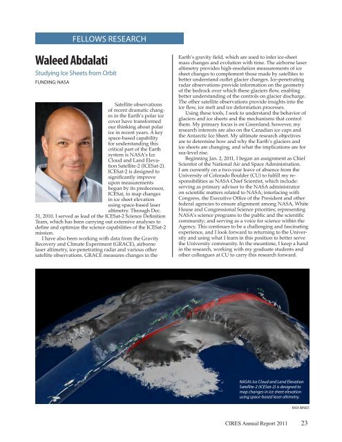
NASA’s Ice Cloud and Land Elevation<br />
Satellite-2 (ICESat-2) is designed to<br />
map changes <strong>in</strong> ice sheet elevation<br />
us<strong>in</strong>g space-based laser altimetry.<br />
NASA IMAGES<br />
CIRES Annual Report <strong>2011</strong> 23


