National Digital Forecast Database design and development - NOAA
National Digital Forecast Database design and development - NOAA
National Digital Forecast Database design and development - NOAA

Create successful ePaper yourself
Turn your PDF publications into a flip-book with our unique Google optimized e-Paper software.
12.3 NATIONAL DIGITAL FORECAST DATABASE DESIGN AND DEVELOPMENT<br />
1. INTRODUCTION<br />
The <strong>National</strong> Weather Service (NWS) has undertaken<br />
the <strong>development</strong> of a <strong>National</strong> <strong>Digital</strong> <strong>Forecast</strong> <strong>Database</strong><br />
(NDFD) that will enable NWS customers <strong>and</strong> partners<br />
access to digital forecasts produced by forecasters<br />
at NWS offices nationwide. The NDFD, when complete,<br />
will contain a seamless mosaic of digital forecasts from<br />
more than 120 field offices (Ruth <strong>and</strong> Glahn 2003). NDFD<br />
mosaics are composed of grids of forecast elements produced<br />
at each Weather <strong>Forecast</strong> Office (WFO) by using<br />
the Interactive <strong>Forecast</strong> Preparation System (IFPS). By<br />
late 2003, IFPS will be implemented at all NWS WFOs<br />
(Ruth 2002).<br />
The availability of high-resolution forecast data on<br />
a national scale allows for the creation of a wide range of<br />
graphic, text, <strong>and</strong> image products by the NWS as well as<br />
its customers <strong>and</strong> partners. Such products include:<br />
• <strong>Forecast</strong> text <strong>and</strong> meteograms for any NDFD<br />
gridpoint.<br />
WFO<br />
(128)<br />
RFC<br />
(13)<br />
NCEP<br />
(6)<br />
REGIONAL<br />
OFFICES<br />
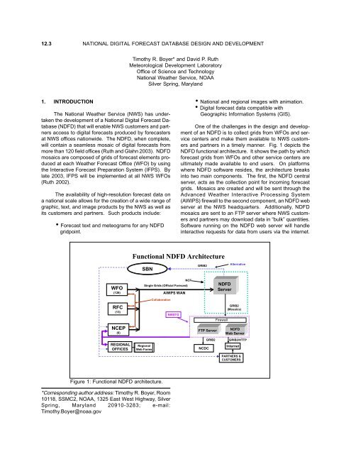
Figure 1: Functional NDFD architecture.<br />
*Corresponding author address: Timothy R. Boyer, Room<br />
10118, SSMC2, <strong>NOAA</strong>, 1325 East West Highway, Silver<br />
Spring, Maryl<strong>and</strong> 20910-3283; e-mail:<br />
Timothy.Boyer@noaa.gov<br />
Timothy R. Boyer* <strong>and</strong> David P. Ruth<br />
Meteorological Development Laboratory<br />
Office of Science <strong>and</strong> Technology<br />
<strong>National</strong> Weather Service, <strong>NOAA</strong><br />
Silver Spring, Maryl<strong>and</strong><br />
Functional NDFD Architecture<br />
SBN<br />
NCF<br />
Single Grids (Official <strong>Forecast</strong>)<br />
Regional<br />
Web Farms<br />
Collaboration<br />
AWIPS WAN<br />
NWSTG<br />
• <strong>National</strong> <strong>and</strong> regional images with animation.<br />
• <strong>Digital</strong> forecast data compatible with<br />
Geographic Information Systems (GIS).<br />
One of the challenges in the <strong>design</strong> <strong>and</strong> <strong>development</strong><br />
of an NDFD is to collect grids from WFOs <strong>and</strong> service<br />
centers <strong>and</strong> make them available to NWS customers<br />
<strong>and</strong> partners in a timely manner. Fig. 1 depicts the<br />
NDFD functional architecture. It shows the path by which<br />
forecast grids from WFOs <strong>and</strong> other service centers are<br />
ultimately made available to end users. On platforms<br />
where NDFD software resides, the architecture breaks<br />
into two main components. The first, the NDFD central<br />
server, acts as the collection point for incoming forecast<br />
grids. Mosaics are created <strong>and</strong> will be sent through the<br />
Advanced Weather Interactive Processing System<br />
(AWIPS) firewall to the second component, an NDFD web<br />
server at the NWS headquarters. Additionally, NDFD<br />
mosaics are sent to an FTP server where NWS customers<br />
<strong>and</strong> partners may download data in “bulk” quantities.<br />
Software running on the NDFD web server will h<strong>and</strong>le<br />
interactive requests for data from users via the internet.<br />
GRIB2<br />
FTP Server<br />
NCDC<br />
NDFD<br />
Server<br />
Alternative<br />
GRIB2<br />
(Mosaics)<br />
<br />
Firewall<br />
<br />
GRIB2<br />
NDFD<br />
Web Server<br />
GRIB2/HTTP<br />
Internet<br />
PARTNERS &<br />
CUSTOMERS
<strong>Forecast</strong> mosaics made available on the web server are<br />
intended for less intensive but more user-specific data<br />
access. NDFD web server software will also reside at<br />
NWS Regional “web farms” that will function as mirror<br />
sites for NDFD data. At some point in the future, NDFD<br />
mosaics may also be transmitted over the AWIPS Satellite<br />
Broadcast Network (SBN).<br />
This paper describes the process by which digital<br />
forecast data produced at WFOs <strong>and</strong> NWS service centers<br />
is transformed into national-scale products <strong>and</strong> made<br />
available to the public. NDFD software is currently being<br />
developed at the Meteorological Development Laboratory<br />
(MDL) at the NWS headquarters. Images from the<br />
initial prototype of the NDFD were first made available in<br />
March 2002 to a h<strong>and</strong>ful of WFOs participating in the<br />
experiment. By summer 2003, grids from all WFOs in<br />
the conterminous United States (CONUS) will be available<br />
experimentally.<br />
2. THE NDFD CENTRAL SERVER<br />
When forecasters are prepared to publish their latest<br />
forecast grids to the NDFD, IFPS software at the WFO<br />
encodes the grids in GRIdded Binary data format (GRIB)<br />
prior to transmission to the NDFD central server via the<br />
AWIPS WAN. Only grids that have been updated since<br />
the last transmission are sent by the WFO. Decoding<br />
software on the NDFD server unpacks the encoded grids<br />
<strong>and</strong> stores the data to a Relational <strong>Database</strong> Management<br />
System (RDBMS). A decoder process kicks off once every<br />
5 minutes on the NDFD server. This allows the NDFD to<br />
be updated on a near-continuous basis with forecasts<br />
from WFOs <strong>and</strong> service centers. Every grid received is<br />
stored into the database as a unique entity. In addition<br />
to the actual data, metadata such as geographical<br />
location, grid valid time <strong>and</strong> forecast issuance time are<br />
stored. Issuance time for a forecast grid is the time at<br />
which a WFO wants that grid to become the official<br />
forecast.<br />
NDFD mosaics are created on a routine basis (currently,<br />
once an hour) from individual WFO grids stored in<br />
the database. For each weather element, at every forecast<br />
projection, the database is searched for new WFO<br />
grids. If a new WFO grid is found, that grid’s issuance<br />
time is compared to the current time. If the issuance<br />
time has been reached, the grid is added to the appropriate<br />
mosaic. The AWIPS 227 grid with 5-km grid mesh<br />
length is the grid upon which NDFD mosaics are based.<br />
Mosaics lie on a sub-domain of this grid, with a size of<br />
1073x689 gridpoints. An identification grid that maps<br />
the domain of every WFO to the NDFD grid is used to<br />
produce mosaics. Each mosaic is stored to the RDBMS<br />
after it has been created or updated.<br />
Another process runs on the NDFD central server<br />
that checks consistency of forecasts between neighboring<br />
WFOs. Overlapping gridpoints along WFO boundaries<br />
are analyzed for each weather element grid <strong>and</strong> forecast<br />
values are compared to predetermined discrepancy<br />
thresholds. Gridpoints where thresholds are exceeded<br />
are flagged <strong>and</strong> used to compute forecast consistency<br />
statistics. Additionally, consistency images are generated<br />
that display discrepancies for overlapping points along<br />
WFO boundaries (Fig. 2).<br />
Figure 2: NDFD Mosaic of MaxT <strong>and</strong> an image of discontinuities along WFO boundaries for the mid-Atlantic sector.
Once all mosaics have been produced for a given<br />
issuance of the NDFD, they are encoded in GRIB format.<br />
The encoded grids are transmitted to an FTP server <strong>and</strong><br />
an NDFD web server at the NWS Telecommunications<br />
Gateway (NWSTG). Additionally, mosaics are sent to<br />
the <strong>National</strong> Centers for Environmental Prediction<br />
(NCEP). Encoded NDFD mosaics are created for the<br />
CONUS, <strong>and</strong> also a set of 16 smaller sectors within the<br />
CONUS.<br />
3. NDFD WEB SERVICES<br />
NDFD software will reside on a web server at the<br />
NWS headquarters. Encoded mosaics will be decoded<br />
on the web server as they are received from the NDFD<br />
central server. Unlike the RDBMS on the central server,<br />
the RDBMS on the web server will be configured to store<br />
NDFD data as individual points in the database. Each<br />
gridpoint will be stored as a unique entity with associated<br />
locational, temporal, <strong>and</strong> weather element-specific<br />
metadata. Two critical requirements for the RDBMS on<br />
the web server are optimized capabilities for h<strong>and</strong>ling<br />
geospatial data types as well as the ability to h<strong>and</strong>le the<br />
tremendous load of simultaneous queries expected as<br />
the public begins to access NDFD data.<br />
NDFD web services are <strong>design</strong>ed to give users flexible<br />
access to forecast data while hiding the underlying<br />
implementation of the database. For purposes of data<br />
integrity <strong>and</strong> server security, users are never allowed direct<br />
access to the relational database itself. Table 1 shows<br />
an example of a typical request to the NDFD database<br />
<strong>and</strong> how web services work to provide the data requested<br />
by the user.<br />
Table 1: NDFD Web Services example.<br />
CCCCCllllliiiiieeeeennnnnttttt PPPPPCCCCC<br />
NNNNNDDDDDFFFFFDDDDD WWWWWeeeeebbbbb<br />
SSSSSeeeeerrrrrvvvvviiiiiccccceeeeesssss<br />
wwwwweeeeebbbbb ssssseeeeerrrrrvvvvveeeeerrrrr<br />
RRRRRDDDDDBBBBBMMMMMSSSSS ssssseeeeerrrrrvvvvveeeeerrrrr<br />
( ( ( ( ( ooooonnnnn<br />
w w w w weeeeebbbbb<br />
ssssseeeeerrrrrvvvvveeeeerrrrr)<br />
) ) ) )<br />
Use<br />
APIto<br />
request<br />
NDFD<br />
data<br />
via<br />
SOAP<br />
Receive<br />
SOAP<br />
request<br />
for<br />
data<br />
Validate<br />
request<br />
Formulate<br />
SQL<br />
query<br />
Connect<br />
to<br />
RDBMS<br />
Send<br />
SQL<br />
queryto<br />
RDBMS<br />
Receive<br />
SQL<br />
query<br />
Execute<br />
query<br />
Returndata<br />
to<br />
Web<br />
service<br />
Compress<br />
data<br />
inGRIB2<br />
format<br />
Wrap<br />
GRIB2<br />
message<br />
in<br />
XML<br />
Send<br />
XML<br />
back<br />
to<br />
client<br />
PC<br />
via<br />
SOAP<br />
APIunwraps<br />
XML<br />
APIdecodes<br />
GRIB<br />
to<br />
raw<br />
data<br />
Client<br />
build<br />
product<br />
withraw<br />
data<br />
Initially, a user makes a request to obtain data by<br />
using an Application Programmer Interface (API) that resides<br />
on the user’s platform. The query is generated by<br />
the API <strong>and</strong> sent to the NDFD web server via a Simple<br />
Object Access Protocol (SOAP) request. The SOAP request<br />
is received at the web server <strong>and</strong> checks are made<br />
to validate the request. This validation ensures, among<br />
other things, that the request makes sense <strong>and</strong> is not<br />
excessively large. Once the request passes validation, a<br />
Structured Query Language (SQL) comm<strong>and</strong> is generated<br />
to fetch the user-requested data from the RDBMS.<br />
Prior to returning the data to the user, the data are<br />
compressed into GRIB format <strong>and</strong> the entire set of data<br />
is wrapped in an eXtensible Markup Language (XML) message.<br />
An API on the user platform unwraps <strong>and</strong> decodes<br />
the data, making it available for user-defined applications.<br />
NDFD web services will allow data to be quickly <strong>and</strong> easily<br />
obtained for user-specified geographic regions, time<br />
ranges, <strong>and</strong> weather elements. They also provide a st<strong>and</strong>ardized<br />
method to query <strong>and</strong> retrieve data from the<br />
NDFD.<br />
4. FUTURE PLANS<br />
Design <strong>and</strong> <strong>development</strong> of NDFD software is an<br />
ongoing effort at MDL. Current tasks include the addition<br />
of non-CONUS areas (e.g., Alaska <strong>and</strong> Hawaii). These<br />
regions must be uniquely h<strong>and</strong>led within the <strong>design</strong><br />
framework of the NDFD due to their size <strong>and</strong> differing<br />
grid definitions. In the future, the NDFD will also include<br />
grids of 3-dimensional aviation forecast elements. A<br />
software improvement that may be implemented is the<br />
addition of a geospatial-type database on the NDFD<br />
central server for increased mosaic generation<br />
performance. Examples of APIs used to access NDFD<br />
data via web services will be provided to NWS customers<br />
<strong>and</strong> partners to promote end-user <strong>development</strong> of<br />
applications that take advantage of this growing wealth<br />
of available data. Through the high-resolution digital<br />
forecast data contained within the NDFD, the NWS will<br />
give its customers <strong>and</strong> partners increasing access to one<br />
of its primary assets, the knowledge <strong>and</strong> experience of<br />
its forecasters.<br />
5. REFERENCES<br />
Ruth, D. P., 2002: Interactive <strong>Forecast</strong> Preparation -<br />
The Future Has Come, Preprints Interactive Symp.<br />
on AWIPS, Orl<strong>and</strong>o, Amer. Meteor. Soc., 20-22.<br />
_____, D. P., <strong>and</strong> H. R. Glahn, 2003: Creating a <strong>National</strong><br />
<strong>Digital</strong> <strong>Forecast</strong> <strong>Database</strong> of Official <strong>National</strong><br />
Weather Service <strong>Forecast</strong>s. Preprints 19th Int. Conf.<br />
on Interactive Information <strong>and</strong> Processing Systems<br />
for Meteorology, Oceanography, <strong>and</strong> Hydrology,<br />
Long Beach, Amer. Meteor. Soc., elsewhere in this<br />
volume.