Evidence for Neoglacial Solifluction at Okstindan, North ... - arctic
Evidence for Neoglacial Solifluction at Okstindan, North ... - arctic
Evidence for Neoglacial Solifluction at Okstindan, North ... - arctic

Create successful ePaper yourself
Turn your PDF publications into a flip-book with our unique Google optimized e-Paper software.
<strong>Evidence</strong> <strong>for</strong> <strong>Neoglacial</strong> <strong>Solifluction</strong><br />
<strong>at</strong> <strong>Okstindan</strong>, <strong>North</strong> Norway1<br />
PETER WORSLEYL and CHARLES HARRIS3<br />
ABSTRACT. A section excav<strong>at</strong>ed through two adjacent turf-banked solifluction<br />
lobes has revealed buried soils bene<strong>at</strong>h each solifluction sheet. Five radiocarbon<br />
d<strong>at</strong>es are reported from the buried soils and these reveal evidence of soil movement<br />
which probably extends over nearly 3,000 years until the present. The initi<strong>at</strong>ion of<br />
the movement appears to be linked to the l<strong>at</strong>e Sub-Boreal clim<strong>at</strong>ic deterior<strong>at</strong>ion<br />
and <strong>Neoglacial</strong> glacier expansion which induced the development of a l<strong>at</strong>e-lying<br />
snow p<strong>at</strong>ch <strong>at</strong> the study site. The first period of movement appears to have been<br />
faster than th<strong>at</strong> during the l<strong>at</strong>er phase. It is suggested th<strong>at</strong> this reduced r<strong>at</strong>e is<br />
associ<strong>at</strong>ed with a decrease in slope angle and to increased distance from the l<strong>at</strong>e-<br />
lying snow bank <strong>at</strong> the head of the slope, r<strong>at</strong>her than to a less severe clim<strong>at</strong>ic<br />
environment.<br />
RÉSUMÉ. Indices de solifluxion néoglaciaire d <strong>Okstindan</strong>, dans le nord de la<br />
Norvège. Une section creusée à travers deux lobes de solifluxion adjacents et bordés<br />
de gazon a révélé la présence de sols enfouis sous chaque nappe de solifluxion. Les<br />
auteurs présentent cinq radiod<strong>at</strong><strong>at</strong>ions de ces sols enfouis, qui donnent la preuve<br />
d'un mouvement du sol qui s'étend probablement sur 3,000 ans jusqu'au Présent.<br />
Le début de ce mouvement semble lié à la détérior<strong>at</strong>ion du clim<strong>at</strong> à la fin du Sub-<br />
boréal et B l'expansion des glaciers au Néoglaciaire, qui ont provoqué le développe-<br />
ment d'une flaque de neige tardive sur le site étudié. La première période de<br />
mouvement semble plus rapide que la seconde. Les auteurs suggèrent que ce ralen-<br />
tissement est lié à une réduction de la pente et à I'éloignement progressif du banc<br />
de neige tardif au sommet de la pente, plutôt qu'à un milieu clim<strong>at</strong>ique moins sévère.<br />
INTRODUCTION<br />
The measurement of current r<strong>at</strong>es of solifluction has been practised <strong>at</strong> various<br />
loc<strong>at</strong>ions throughout the widespread periglacial environments of the world. Con-<br />
sequently it is now possible to undertake compar<strong>at</strong>ive studies of the contemporary<br />
vari<strong>at</strong>ion in the established r<strong>at</strong>es of movement and rel<strong>at</strong>e these to the range of<br />
factors which influence them, especially precise clim<strong>at</strong>ic factors. A fundamental<br />
problem associ<strong>at</strong>ed with d<strong>at</strong>a derived from such investig<strong>at</strong>ions rel<strong>at</strong>es to an<br />
1<strong>Okstindan</strong> Research Project Report no. 3.<br />
*Department of Geography, The University, Reading, RG6 2AF, England.<br />
3Department of Geology, University College, Cardiff, CF1 IXL, Wales.
EVIDENCE FOR NEOGLACIAL SOLIFLUCTION 129<br />
assessment of its long-term validity. Few sites have been monitored <strong>for</strong> more than<br />
25 years and, even if the results of measurements taken over an entire life span<br />
were available, the true geomorphological significance would remain somewh<strong>at</strong><br />
difficult to evalu<strong>at</strong>e. A further problem concerns the dur<strong>at</strong>ion of solifluction con-<br />
ditions during the period since the end of the last major glaci<strong>at</strong>ion. Clearly,<br />
there<strong>for</strong>e, altern<strong>at</strong>ive methods are required if <strong>at</strong>tempts are to be made to make<br />
meaningful generaliz<strong>at</strong>ions concerning the d<strong>at</strong>ing, total amount and possible<br />
significance of this particular kind of periglacial mass movement during the post-<br />
glacial period.<br />
One approach to this problem which has been adopted is to select a site con-<br />
taining a well-marked linear morphological fe<strong>at</strong>ure rel<strong>at</strong>ed to an event of known<br />
age, and then to measure the total amount of modific<strong>at</strong>ion which has occurred<br />
since its <strong>for</strong>m<strong>at</strong>ion. An example of this l<strong>at</strong>ter type of situ<strong>at</strong>ion is af<strong>for</strong>ded by Lin-<br />
dell's (1966) study of the postglacial de<strong>for</strong>m<strong>at</strong>ion of ice-dammed, lake shore-<br />
lines in the Grovelsjo area of west central Sweden. In this instance between<br />
2 and 9 metres of downslope solifluctional displacement of <strong>for</strong>mer wave washing<br />
fe<strong>at</strong>ures cut in till could be demonstr<strong>at</strong>ed as having developed since around 8,000<br />
years BP, as d<strong>at</strong>ed on the varve time scale. However, such sites are uncommon,<br />
and this particular example occurred where the surface slope was in the range<br />
of 25-33 degrees, a value much higher than th<strong>at</strong> which is often encountered<br />
in areas exhibiting extensive solifluction. Thus it can be readily appreci<strong>at</strong>ed th<strong>at</strong><br />
this type of approach must necessarily be restricted to only a few areas.<br />
In the absence of a synchronous morphological fe<strong>at</strong>ure, the altern<strong>at</strong>ive is to<br />
have recourse to str<strong>at</strong>igraphic techniques which, <strong>for</strong>tun<strong>at</strong>ely, happen to be espe-<br />
cially appropri<strong>at</strong>e in areas of extensive solifluction because of the n<strong>at</strong>ure of the<br />
process itself. The l<strong>at</strong>ter invariably involves the overriding and burial of land<br />
surfaces immedi<strong>at</strong>ely in front of the risers of solifluction lobes. Consequently, <strong>at</strong><br />
the base of such land<strong>for</strong>ms there often occur buried phenomena which display<br />
characteristics inherited from the land surface overridden by <strong>for</strong>ward movement<br />
of the lobe front. These usually consist of fossil soils incorpor<strong>at</strong>ing humic horizons,<br />
representing the organic accumul<strong>at</strong>ions on the <strong>for</strong>mer surface. This organic ma-<br />
terial is amenable to radiocarbon d<strong>at</strong>ing and consequently it is possible, theoret-<br />
ically <strong>at</strong> least, to obtain numerical in<strong>for</strong>m<strong>at</strong>ion on the timing, amount and estim<strong>at</strong>es<br />
of the long-term average r<strong>at</strong>es of movement expressed in radiocarbon years. The<br />
occurrence of buried humic rich layers bene<strong>at</strong>h solifluction lobes and terraces<br />
is much noted in the liter<strong>at</strong>ure (<strong>for</strong> example, Williams 1957), although only two<br />
localities are known to the present writers where radiocarbon d<strong>at</strong>ing has been<br />
system<strong>at</strong>ically applied: namely, the Colorado Front Range (Benedict 1966, 1970)<br />
and Mt. Kosciusko, Snowy Mountains, Australia (Costin et al. 1967).<br />
Turf-banked solifluction lobes have been subjected to detailed investig<strong>at</strong>ions<br />
since 1968 as an integral part of the University of Reading's <strong>Okstindan</strong> Research<br />
Programme. Progress reports concerning current frost creep and solifluction pro-<br />
cess studies have already been published by Harris (1972, 1973). These pertain<br />
to the study site to be considered further in this paper, the objective of which<br />
is to report evidence bearing on the basic evalu<strong>at</strong>ion problem which has been<br />
outlined above, and to consider how this fits into the current picture of clim<strong>at</strong>ic
130 EVIDENCE FOR NEOGLACIAL SOLIFLUCTION<br />
history during the postglacial period in Scandinavia. It is considered by the writers<br />
th<strong>at</strong> solifluction has probably oper<strong>at</strong>ed in the <strong>Okstindan</strong> area since <strong>at</strong> least 2,500<br />
years BP -th<strong>at</strong> is, within the time span of Neoglaci<strong>at</strong>ion.<br />
The chronological term <strong>Neoglacial</strong> is here used in the way defined by Flint<br />
(1971); th<strong>at</strong> is, it concerns the birth and/or growth of glaciers following the Hyp-<br />
sithermal interval (clim<strong>at</strong>ic optimum). The other potentially ambiguous term<br />
“postglacial” is here used in an in<strong>for</strong>mal sense and is restricted to the period of<br />
time from the dissip<strong>at</strong>ion of the last inland ice cover in the Scandinavian context.<br />
LOCAL SITE ENVIRONMENT<br />
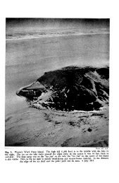
The site to be described is loc<strong>at</strong>ed <strong>at</strong> the eastern exit of an east-west trending<br />
valley unofficially called Austre Okstindbredal, and lies <strong>at</strong> an altitude of 710 m.<br />
Immedi<strong>at</strong>ely to the southwest lies the <strong>Okstindan</strong> ice cap which is situ<strong>at</strong>ed across<br />
l<strong>at</strong>itude 66”N in Nordland County, north Norway. An outlet glacier, Austre<br />
Okstindbreen, descends from the ice cap to block the western end of Austre<br />
Okstindbredal. This glacier has been in essentially continuous retre<strong>at</strong> in recent<br />
years, and is now approxim<strong>at</strong>ely 2.0 km. distant from the study site (see Fig. 1).<br />
\ I<br />
10 20 km<br />
FIG. 1. Loc<strong>at</strong>ion of the<br />
<strong>Okstindan</strong> ice cap and the<br />
study site.
EVIDENCE FOR NEOGLACIAL SOLIFLUCTION 131<br />
Precise clim<strong>at</strong>ological d<strong>at</strong>a <strong>for</strong> the area are not available but, on the basis of extrapol<strong>at</strong>ion<br />
from the nearest Norwegian inland meteorological st<strong>at</strong>ion <strong>at</strong> H<strong>at</strong>tfjelldal<br />
and from incomplete observ<strong>at</strong>ion from the site and the nearby Okstindsjgen Field<br />
St<strong>at</strong>ion, the mean annual temper<strong>at</strong>ure is estim<strong>at</strong>ed as - 3" C.<br />
The solifluction lobes are developed on an east-facing slope with a gradient<br />
ranging between 5 O and 17". Apart from the surficial mass-movement layer of<br />
about 1 metre in thickness, the slope is underlain by till which is banked against<br />
a heavily stri<strong>at</strong>ed and glacially smoothed bedrock knoll protruding into the valley<br />
from the northern side (see Fig. 2). The lobes are <strong>for</strong>med from a remanié silty<br />
sandy till and lie downslope from a snow p<strong>at</strong>ch which persists well into the summer<br />
during most years. In terms of the altitudinal sequence of veget<strong>at</strong>ion belts recognized<br />
in Scandinavia (Sjors 1967) the site lies in the low alpine belt. However the<br />
upper limit of the sub-alpine birchwood belt reaches an elev<strong>at</strong>ion of only 40 m.<br />
below th<strong>at</strong> of the study locality <strong>at</strong> a distance of 400 m. to the east. At the surface<br />
the veget<strong>at</strong>ion consists mainly of Bearberry (Arctostaphylos alpina), Crowberry<br />
(Empetrum nigrurn), Least Willow (Sulix herbacea), Dwarf Birch (Betula nuna),<br />
Billberry (Vaccinium myrtillus), and Carex spp. Below the veget<strong>at</strong>ion m<strong>at</strong> a<br />
thin soil is present, probably best described as a skeletal brown earth. A full soil<br />
profile description together with analytical d<strong>at</strong>a is given in the appendix.<br />
STRATIGRAPHY<br />
To obtain an insight into the general site str<strong>at</strong>igraphy a trench 10 m. long<br />
and 1.5 m. deep was excav<strong>at</strong>ed. This lay along a transect parallel with the slope<br />
in an area where disturbance of the ground during excav<strong>at</strong>ion would not adversely<br />
affect the instrument<strong>at</strong>ion installed <strong>for</strong> the process investig<strong>at</strong>ions - th<strong>at</strong> is, be-<br />
tween sites B and C of Harris (1972). The section in the trench revealed the<br />
str<strong>at</strong>igraphy through two turf-banked lobes.<br />
Where the two lobe fronts (risers) made contact with the adjacent treads,<br />
it was apparent th<strong>at</strong> an organic-rich horizon could be traced along the upslope<br />
projection of the tread surface which lay downslope from each lobe (see Fig. 2).
132 EVIDENCE FOR NEOGLACIAL SOLIFLUCTION<br />
It was clear th<strong>at</strong> the creep and/or flow of the lobes had progressively buried the<br />
tread surfaces lying in the p<strong>at</strong>h of the movement. The organic horizon of the<br />
lower lobe could be traced back from the lobe front <strong>for</strong> a distance of 5.5 m.<br />
and th<strong>at</strong> of the upper lobe <strong>for</strong> a minimum distance of 3.5 m., since it had not<br />
failed <strong>at</strong> the head of the trench section. In the <strong>for</strong>mer case, as it was traced upslope<br />
away from the lobe front, the organic horizon became thinner and less distinct,<br />
but in no instance was it seen to be broken be<strong>for</strong>e it finally became indistinguishable.<br />
The two organic beds are considered to be buried soils. Associ<strong>at</strong>ed with<br />
the frontal parts of both lobes were other subsurface organic beds, but these<br />
were of r<strong>at</strong>her restricted extent. It is suggested th<strong>at</strong> these minor organic horizons<br />
represent <strong>for</strong>mer poorly developed soils which had <strong>for</strong>med on the lobe surfaces<br />
during <strong>for</strong>mer periods of rel<strong>at</strong>ive stability. This proposal is consistent with the<br />
general concept which emerged from the contemporary process study, th<strong>at</strong> an important<br />
element of the present-day movement might be associ<strong>at</strong>ed with the rare<br />
event when a certain combin<strong>at</strong>ion of environmental factors is in phase. Thus<br />
a period of r<strong>at</strong>es of movement well above average may occur from time to time<br />
to produce an untypically large amount of movement in a particular year. This<br />
unusual happening could well take the <strong>for</strong>m of acceler<strong>at</strong>ed movement of nearsurface<br />
m<strong>at</strong>erial in the frontal zone by s<strong>at</strong>ur<strong>at</strong>ed flow, and thereby cause the type<br />
of complex p<strong>at</strong>tern of organic horizons observed in the frontal part of the lobes.<br />
Nine samples from represent<strong>at</strong>ive parts of the section were tested <strong>for</strong> moisture<br />
content, Atterberg limits and loss on ignition, and the results are presented in<br />
Table 1. From this it may be seen th<strong>at</strong> the high organic content of the buried soil is<br />
demonstr<strong>at</strong>ed by the result <strong>for</strong> sample no. 1. The organic m<strong>at</strong>erial is thought to<br />
have an origin in the <strong>for</strong>mer A horizon of the relict soil. <strong>Evidence</strong> to substanti<strong>at</strong>e<br />
this view comes from the observed occurrence of large, rounded cobble- and<br />
boulder-sized m<strong>at</strong>erial concentr<strong>at</strong>ed <strong>at</strong>, or immedi<strong>at</strong>ely below, the buried<br />
organic bed, <strong>for</strong> similar concentr<strong>at</strong>ions are encountered within 0.25 m. of the<br />
present-day surfaces. Other concentr<strong>at</strong>ions of boulders were loc<strong>at</strong>ed <strong>at</strong> the lobe<br />
fronts bene<strong>at</strong>h the veget<strong>at</strong>ion cover, with the long axes imbric<strong>at</strong>ed upslope. Most<br />
of these large clasts were rounded, often stri<strong>at</strong>ed, and were probably derived from<br />
re-cycled m<strong>at</strong>erial from the till. The low values <strong>for</strong> the plastic limit and liquid limit<br />
TABLE 1. Soil properties within the section.<br />
Sample Moisture content Plastic limit Liquid limit Ignition loss<br />
% % % %<br />
24.1<br />
9.5<br />
9.9<br />
19.0<br />
13.1<br />
14.1<br />
9.3<br />
8.4<br />
8.5<br />
55.3<br />
24.3<br />
17.25<br />
27.4<br />
18.5<br />
25.7<br />
21.2<br />
18.6<br />
17.9<br />
56.5<br />
28.5<br />
23.5<br />
31.8<br />
27.0<br />
28 .O<br />
21.5<br />
23.5<br />
29.5<br />
36.1<br />
5.4<br />
3.5<br />
6.3<br />
3.2<br />
5.9<br />
5.0<br />
2.4<br />
3.2
NOIJ3nTdI'IOS TVI3VT603N XOd 33N3aIA3
134 EVIDENCE FOR NEOGLACIAL SOLIFLUCTION<br />
TABLE 2. Radiocarbon ages from the buried soils.<br />
Sample Uncorrected radiocarbon Trondheim sample:<br />
(<strong>for</strong> loc<strong>at</strong>ion Fig. see I) age in BP years<br />
reference no.<br />
1 2480 rt 90<br />
T-1115<br />
2<br />
1420’ 150 T-1116<br />
3 2550 5 80 T-1117<br />
4a 2070 rt 100<br />
T-1118/1<br />
4b<br />
2200 5 150 T-l118/2<br />
As is generally known, one of the basic assumptions made in the calcul<strong>at</strong>ion of<br />
a radiocarbon age is th<strong>at</strong> the level of radiocarbon activity in the biosphere has<br />
remained constant throughout time. Once the technique was applied to samples of<br />
known age, i.e. historically d<strong>at</strong>ed m<strong>at</strong>erial, it became apparent th<strong>at</strong> the discrepancies<br />
which emerged from the results were rel<strong>at</strong>ed to something more fundamental<br />
than simply errors rel<strong>at</strong>ed to the mechanics of prepar<strong>at</strong>ion and counting.<br />
During the last decade careful radiocarbon age determin<strong>at</strong>ions made on samples<br />
derived from precisely-d<strong>at</strong>ed sequences, mainly dendrochronologically d<strong>at</strong>ed wood<br />
specimens, have permitted the production of a graph showing the actual radiocarbon<br />
activity level in the sample with respect to true time. Suess (1970, pl<strong>at</strong>e 1)<br />
published a ‘calibr<strong>at</strong>ion curve’ <strong>for</strong> conventional radiocarbon ages <strong>for</strong> the last<br />
3950 years BP derived from 273 measurements of “bristlecone-pine, wood from<br />
Europe and from the American Sequoia gigantea”. This curve shows th<strong>at</strong> sometimes<br />
the usual st<strong>at</strong>istical uncertainty associ<strong>at</strong>ed with individual radiocarbon d<strong>at</strong>es<br />
is actually increased when the d<strong>at</strong>e is converted into a ‘true’ calendar d<strong>at</strong>e. For<br />
instance, <strong>at</strong> certain periods in calendar time identical radiocarbon d<strong>at</strong>es may result<br />
from age determin<strong>at</strong>ions made on m<strong>at</strong>erials with a known range of true ages.<br />
The discussion <strong>at</strong> the symposium which fe<strong>at</strong>ured the present<strong>at</strong>ion of the Suess<br />
curve showed th<strong>at</strong> it was not accepted unanimously by those radiophysicists<br />
present. There is no doubt th<strong>at</strong> radiocarbon ages diverge from true calendar ages<br />
by a significant amount after about 2,000 years BP in such a way th<strong>at</strong> they are<br />
consistently underestim<strong>at</strong>ed. At the time of writing the deb<strong>at</strong>e continues as to the<br />
precise course of the calibr<strong>at</strong>ion curve, and this is well illustr<strong>at</strong>ed by the discussions<br />
held <strong>at</strong> the l<strong>at</strong>est radiocarbon d<strong>at</strong>ing conference held in New Zealand l<strong>at</strong>e in 1972.<br />
The basic trend of the curve is agreed, but the details of the smaller oscill<strong>at</strong>ions<br />
are not. Until such time as a majority of workers can agree on a means of converting<br />
radiocarbon ages into calendar time, the Qu<strong>at</strong>ernary geologist is faced with the<br />
dilemma of which means of correction to choose. On this occasion the Suess (1970)<br />
curve will be adopted since it is available in a readily-usable <strong>for</strong>m, although it<br />
must be recognized th<strong>at</strong> close inspection reveals the somewh<strong>at</strong> subjective n<strong>at</strong>ure<br />
of its deriv<strong>at</strong>ion from the various age determin<strong>at</strong>ions plotted. The altern<strong>at</strong>ive<br />
approach is to simply “sit on the fence” and <strong>at</strong>tempt no interpret<strong>at</strong>ion until some<br />
future d<strong>at</strong>e. Since this particular case illustr<strong>at</strong>es a problem which will no doubt be<br />
encountered by other workers in the near future it seems profitable to <strong>at</strong>tempt a<br />
conversion into calendar ages so th<strong>at</strong> the problems involved may be clarified.<br />
Thus in Table 3, the radiocarbon ages reported by the Trondheim Labor<strong>at</strong>ory are
EVIDENCE FOR NEOGLACIAL SOLIFLUCTION 135<br />
TABLE 3. Calendar age calcul<strong>at</strong>ed from the Suess (1970) curve.<br />
Sample Radiocarbon age in years BP Converted calendar in age years BP<br />
1 2480 5 90 2640’ 170, (2810 - 2470)<br />
2 14202 150 1380 i 120, (1500 - 1260)<br />
3 2550 5 80 2645 C 175, (2820 - 2470)<br />
4a 2070 5 100 2110 2 210, (2320 - 1900)<br />
4b 2200C 150 2165 C 255, (2420 - 1910)<br />
converted with the aid of the Suess (1970) curve. The present writers cannot<br />
overstress how fully aware they are of the potential dangers associ<strong>at</strong>ed with this<br />
exercise, and would emphasize the tent<strong>at</strong>ive n<strong>at</strong>ure of the conclusions derived<br />
from it. Such are the uncertainties involved th<strong>at</strong> the calendar d<strong>at</strong>es obtained will<br />
be quoted as the lcr range. It can be seen th<strong>at</strong> the f lu uncertainty factor has<br />
actually increased in four of the results and only decreased in one (sample no. 2).<br />
APPLICATION OF RADIOCARBON RESULTS<br />
Two issues arise rel<strong>at</strong>ed to the applic<strong>at</strong>ion of the radiocarbon d<strong>at</strong>es to the buried<br />
soils. This general topic has been previously discussed by Benedict (1966) and<br />
only a brief outline need be given here.<br />
(1) A modern soil, especially the A horizon, will consist essentially of a mixture<br />
of the modern veget<strong>at</strong>ion and the decaying remains of past veget<strong>at</strong>ion, and consequently<br />
such an horizon will have an age, in terms of its radiocarbon content,<br />
which will be determined by the average period of residence of the organic m<strong>at</strong>erial<br />
<strong>at</strong> a given level. In time, oxid<strong>at</strong>ion and/or leaching will promote the breakdown<br />
of the organic m<strong>at</strong>ter which will then gradually move down the profile to lower<br />
horizons. As this process progresses the radiocarbon content will decrease with<br />
depth and the age will also, there<strong>for</strong>e, increase with depth. However, concurrently<br />
with this process, new m<strong>at</strong>erial will continually be contributed from the veget<strong>at</strong>ion<br />
m<strong>at</strong> above. This concept of a dynamic equilibrium in the soil profile was hst<br />
coherently expressed by Niki<strong>for</strong>off (1942), and it follows th<strong>at</strong> in a fully-developed<br />
soil the radiocarbon age will, theoretically, remain constant provided th<strong>at</strong> the<br />
general environment does not change.<br />
(2) The second issue requiring consider<strong>at</strong>ion concerns the sp<strong>at</strong>ial characteristics<br />
of a buried soil with respect to time. Can it be assumed th<strong>at</strong> the whole buried soil<br />
had an “average period of residence age” similar to th<strong>at</strong> of a modern soil? Th<strong>at</strong> is,<br />
was the soil fully developed <strong>at</strong> the time of burial, since if it were not, then possibly<br />
its “age” may have been less than th<strong>at</strong> held by the modern soil. It is assumed in this<br />
case th<strong>at</strong> the soil, once buried, becomes truly inert with respect to modern soil<br />
<strong>for</strong>ming processes, and in particular no organic m<strong>at</strong>erial of any age is subsequently<br />
added to it. In view of the thickness of the overlying sheet of solifluction m<strong>at</strong>erial<br />
in the case under discussion, this seems to the writers to be a reasonable assumption<br />
to make.<br />
With respect to the <strong>Okstindan</strong> situ<strong>at</strong>ion it is un<strong>for</strong>tun<strong>at</strong>e th<strong>at</strong> the modern soil<br />
was not radiocarbon d<strong>at</strong>ed, but hancial resources did not permit more than four
136 EVIDENCE FOR NEOGLACIAL SOLIFLUCTION<br />
TABLE 4. Jotunheimen soil radiocarbon d<strong>at</strong>es (Idstrem 1965).<br />
Locality Height (m.) Depth (cm.) D<strong>at</strong>e Reference No.<br />
Grisubreen 1900 surface modem T-405<br />
Smidalen 1200 3-5 250 St-1364<br />
Veodalen 1350 3-5 385 2 70 St-1366<br />
d<strong>at</strong>ings from this locality to be commissioned. In the absence of such infom<strong>at</strong>ion,<br />
evidence <strong>for</strong> modern soil age from the <strong>arctic</strong>-alpine zone of Scandinavia is required.<br />
As part of a comprehensive study of ice-cored moraine ridges, gstrem (1965)<br />
investig<strong>at</strong>ed the radiocarbon age of modern soils adjacent to some glaciers in the<br />
Jotunheimen of south Norway and Kebnekaise in Swedish Lapland. Many of his<br />
results proved to be anomalous owing to contamin<strong>at</strong>ion of the soils by infinitely<br />
old graphite derived from the local bedrock. However, three of his results obtained<br />
from soil m<strong>at</strong>erial which chemical analysis subsequently showed to be uncontamin<strong>at</strong>ed<br />
by graphite may be useful in the present context. These d<strong>at</strong>es are shown<br />
in Table 4.<br />
As is predictable from theory, the surface sample from GrHsubreen was und<strong>at</strong>able,<br />
being composed of present-day organic m<strong>at</strong>erial plus some which must<br />
have died in the very recent past, and so it was impossible to measure a radiocarbon<br />
decay r<strong>at</strong>e below the standard in the sample. The other two results suggest th<strong>at</strong><br />
the soil A horizon has an age ranging from 0-455 years <strong>at</strong> -t IC+. Apart from these<br />
d<strong>at</strong>es, no other published in<strong>for</strong>m<strong>at</strong>ion from comparable environments is known<br />
to the writers, except Benedict’s result from the modern soil in Colorado of<br />
355 t 115 years BP (1-1510). The depth of this l<strong>at</strong>ter sample was not given in<br />
the text, but is estim<strong>at</strong>ed as approxim<strong>at</strong>ely 0.10 m. from Fig. 4 of Benedict (1966).<br />
On the basis of this it can be suggested th<strong>at</strong> the radiocarbon age of the modern<br />
soil <strong>at</strong> the study site is likely to be of the order of a few hundred years <strong>at</strong> the most.<br />
Unpublished d<strong>at</strong>a from the Sarek Mountains, which lie between <strong>Okstindan</strong> and<br />
Kebnekaise, are consistent with this conclusion (George Denton, personal communic<strong>at</strong>ion,<br />
1973). Accepting this, it seems to the writers th<strong>at</strong> when the applic<strong>at</strong>ion<br />
of a correction factor based on the age of the modern soil is considered in rel<strong>at</strong>ion<br />
to the buried soils in this instance, the procedure becomes absurd. This is because<br />
of the paucity of d<strong>at</strong>a on the ages of modern sub-<strong>arctic</strong> type soils and, more<br />
important, the vagaries of the Suess calibr<strong>at</strong>ion curve between 2,000-3,000 and<br />
0-450 years BP. Thus any <strong>at</strong>tempt to calcul<strong>at</strong>e an average figure from the in<strong>for</strong>m<strong>at</strong>ion<br />
available would be both meaningless and dishonest in th<strong>at</strong> it would give a<br />
false sense of accuracy to the result. Accordingly this particular correction factor<br />
has been ignored.<br />
TIMING AND RATES OF SOLIFLUCTION<br />
It is clear from the discussion above th<strong>at</strong> evalu<strong>at</strong>ions of timing and r<strong>at</strong>es of<br />
solifluction based upon radiocarbon d<strong>at</strong>ing evidence must necessarily be very<br />
tent<strong>at</strong>ive. When considering the f lcr ranges of the two oldest samples, the degree
EVIDENCE FOR NEOGLACIAL SOLIFLUCTION 137<br />
of coincidence is obvious. The str<strong>at</strong>igraphic rel<strong>at</strong>ionships in conjunction with the<br />
d<strong>at</strong>es indic<strong>at</strong>e th<strong>at</strong> this part of the soil, then lying <strong>at</strong> the surface, became buried<br />
sometime after about 2,800 years BP. The field d<strong>at</strong>a are considered insufficient<br />
to permit a positive conclusion being drawn concerning the thinning of the outcrop<br />
in the section when traced upslope. This might signify either progressive imm<strong>at</strong>urity<br />
or differential post-<strong>for</strong>m<strong>at</strong>ional erosion. The site characteristics suggest th<strong>at</strong>,<br />
perhaps a few centuries previous to the d<strong>at</strong>e of the oldest buried soil which has been<br />
preserved, higher up the slope, a snow p<strong>at</strong>ch had started to persist into the summer,<br />
thereby promoting solifluction processes on the slope. In the absence of other<br />
d<strong>at</strong>a suggesting the contrary, the simplest interpret<strong>at</strong>ion would be to propose th<strong>at</strong><br />
the pre-existing soil which had developed during the period be<strong>for</strong>e the clim<strong>at</strong>ic<br />
deterior<strong>at</strong>ion was initially destroyed in the newly-established periglacial environment.<br />
We can only specul<strong>at</strong>e as to whether this was the first major solifluction<br />
episode to occur <strong>at</strong> the study site since the wastage of the inland ice which<br />
probably took place about 9,000 years BP. If it were, then a partial explan<strong>at</strong>ion<br />
would exist as to why solifluction associ<strong>at</strong>ed with the last 3-4 centuries has not<br />
apparently caused any widespread destruction of the soil cover in the area. It<br />
could be th<strong>at</strong> the slope had been reduced in the early first millennium BC by<br />
periglacial conditions to such an extent th<strong>at</strong> the subsequent solifluction periods<br />
have been less effective. Certainly the measurements of current movements are<br />
consistent with a rel<strong>at</strong>ively low level of activity in the present clim<strong>at</strong>ic environment.<br />
More d<strong>at</strong>es will be required from the buried soil be<strong>for</strong>e an <strong>at</strong>tempt can be made<br />
to obtain a detailed picture of past vari<strong>at</strong>ions in the manner achieved by J. B.<br />
Benedict (1966) who, it should perhaps be noted, did not have the possibility of<br />
correcting his d<strong>at</strong>es in the light of modern knowledge concerning past levels of<br />
radiocarbon in the <strong>at</strong>mosphere. From the d<strong>at</strong>es available from <strong>Okstindan</strong> an<br />
<strong>at</strong>tempt can be made to obtain an idea of the likely approxim<strong>at</strong>e r<strong>at</strong>es of solifluction<br />
movement. This can be done in terms of the average along the whole section or<br />
in two stages of 2 m. and 1 m. in length respectively. In each case the r<strong>at</strong>es will be<br />
calcul<strong>at</strong>ed with respect to AD 1970, and to facilit<strong>at</strong>e discussion the two stages will<br />
be termed (a) and (b) <strong>for</strong> the newer and older stages. As we have seen, all the sample<br />
ages include a “mean residence time factor” which makes them slightly older than<br />
the burial event. The modern reference year in this case is AD 1970 (strictly - 20<br />
years BP) which does not include such a factor, and hence in the calcul<strong>at</strong>ion of the<br />
average r<strong>at</strong>es of movement the resultant will be a little underestim<strong>at</strong>ed.<br />
TABLE 5. Approxim<strong>at</strong>e past r<strong>at</strong>es of lobe front movement.<br />
(assuming th<strong>at</strong> the corrected radiocarbon d<strong>at</strong>es are accur<strong>at</strong>e)<br />
Distance upslope D<strong>at</strong>e of Average r<strong>at</strong>e Average r<strong>at</strong>e<br />
Lobe from present front burial in (a) stage in stage (b)<br />
Upper 3 m.<br />
1 m.<br />
2640<br />
1380 1.59 mm/yr. 0.71 mm./yr.<br />
Lower 3 m.<br />
1 m.<br />
2645<br />
2137* 3.94 mmlyr. 0.46 mm./yr.<br />
*mean of samples 4a and 4b. (See table 3)
138 EVIDENCE FOR NEOGLACIAL SOLIFLUCTION<br />
From the d<strong>at</strong>a given in Table 5 it can readily be seen th<strong>at</strong> the average r<strong>at</strong>e of<br />
movement along the whole of each lobe section must inevitably be very similar,<br />
since the two starting d<strong>at</strong>es are almost identical and the total distance involved<br />
is the same. When the breakdown into the two stages (a) and (b) is examined, it<br />
appears th<strong>at</strong> there was a significantly gre<strong>at</strong>er movement r<strong>at</strong>e in the past than in<br />
more recent times. As has been commented upon earlier in this paper, this apparent<br />
reduction in the movement r<strong>at</strong>es of the lobe fronts does not necessarily indic<strong>at</strong>e<br />
th<strong>at</strong> the periglacial environment has become any less severe clim<strong>at</strong>ically as the<br />
present is approached. This is because the r<strong>at</strong>e of soil movement under present-day<br />
conditions decreases downslope, seemingly as the effects of the l<strong>at</strong>e-lying snow<br />
p<strong>at</strong>ch <strong>at</strong> the head of the slope decreases and the slope angle is reduced. Thus it<br />
might be expected th<strong>at</strong> the r<strong>at</strong>e of migr<strong>at</strong>ion would have decreased with time as<br />
the lobes became more distant from the snow bank <strong>at</strong> the head of the slope.<br />
The calcul<strong>at</strong>ed average movement r<strong>at</strong>es associ<strong>at</strong>ed with each stage obviously<br />
show no correl<strong>at</strong>ion between the respective values from the upper and lower lobes.<br />
This apparent anomaly can be considered from two standpoints:-<br />
(i) on the assumption th<strong>at</strong> the d<strong>at</strong>es are accur<strong>at</strong>e. Here the d<strong>at</strong>es can be interpreted<br />
as indic<strong>at</strong>ing th<strong>at</strong> during the (a) stage of movement the upper lobe was<br />
moving less rapidly than the lower. Normally the reverse might be expected, since<br />
the effects of the snow p<strong>at</strong>ch should have been gre<strong>at</strong>er upslope, as just noted. Since<br />
the two lobes exhibit insignificant differences in slope angle, this factor is unlikely<br />
to have influenced this issue. Thus from a geomorphological point of view it appears<br />
th<strong>at</strong> one of the lower d<strong>at</strong>es is inconsistent with theory.<br />
(ii) assume th<strong>at</strong> the d<strong>at</strong>es are incorrect. Since the two upslope d<strong>at</strong>es are in each<br />
instance so similar, it is impossible to evalu<strong>at</strong>e these independently on the basis<br />
of the present d<strong>at</strong>a. However it should be observed th<strong>at</strong> both of these samples<br />
occur <strong>at</strong> the same distance from the lobe fronts (3 m.). Making the simplest<br />
assumption th<strong>at</strong> the total <strong>for</strong>ward movement of each lobe over time has been the<br />
same, then the predicted ages should be alike, as is the case in this instance.<br />
Attention must, there<strong>for</strong>e, be focused on the downslope d<strong>at</strong>es, and in this instance<br />
we <strong>for</strong>tun<strong>at</strong>ely have a check on the accuracy of sample no. 4, since two age<br />
determin<strong>at</strong>ions were made on this, one on the bulk sample and the other on the<br />
alkaline soluble fraction. Since the f la uncertainties from these two determin<strong>at</strong>ions<br />
clearly overlap there is good reason to believe th<strong>at</strong> these are more likely to<br />
be correct than is the single determin<strong>at</strong>ion. Thus it can be suggested th<strong>at</strong> the d<strong>at</strong>e<br />
from sample no. 2 may be erroneous, and possibly it may be too young due to<br />
contamin<strong>at</strong>ion by some younger m<strong>at</strong>erial. Should this be so, then the higher r<strong>at</strong>e<br />
of movement of stage (a) - th<strong>at</strong> is, the r<strong>at</strong>e obtained from the lower lobe - may<br />
be more reliable. It may just be possible th<strong>at</strong> the discrepancy is linked to the<br />
vagaries of the fluctu<strong>at</strong>ions in biospheric radiocarbon level.<br />
We may conclude th<strong>at</strong> on the whole it is more likely th<strong>at</strong> the concept of an<br />
initially more rapid period of movement followed by a much longer period of lower<br />
movement r<strong>at</strong>es is the more realistic interpret<strong>at</strong>ion of the evidence. A movement<br />
r<strong>at</strong>e in the first or (a) stage seems to have approached an average of 4.0 mm./year,<br />
and in the l<strong>at</strong>er (b) stage an average r<strong>at</strong>e below 0.5 mm./year obtained. However<br />
it is again stressed th<strong>at</strong> these figures should not be taken as precise values. It has
EVIDENCE FOR NEOGLACIAL SOLIFLUCTION 139<br />
been seen th<strong>at</strong> the lobe str<strong>at</strong>igraphy may be interpreted in terms of occasional<br />
rel<strong>at</strong>ively rapid movements r<strong>at</strong>her than of a steady progressive creep r<strong>at</strong>e. Thus<br />
upon a probable overall reduction in the movement r<strong>at</strong>e there were likely to have<br />
been superimposed short term fluctu<strong>at</strong>ions rel<strong>at</strong>ed to rare events promoting more<br />
rapid slope failure.<br />
c14 DATINGS AND POSTGLACIAL CHRONOLOGY<br />
The rel<strong>at</strong>ion of the C14 d<strong>at</strong>ings to the known Scandinavian postglacial chronol-<br />
ogy is perhaps best achieved by discussion under three headings:-<br />
(a) <strong>Evidence</strong> from the <strong>Okstindan</strong>area<br />
The till and glacially eroded bedrock surface <strong>at</strong> the solifluction site are thought<br />
to be the products of the last major Scandinavian glaci<strong>at</strong>ion (Weichselian), a period<br />
during which ice derived from Sweden moved westwards across the <strong>Okstindan</strong><br />
area towards the Atlantic Ocean. This event termin<strong>at</strong>ed in the area under discussion<br />
during the early part of the Holocene and thus there is an older age limit to the<br />
site. The glacier Austre Okstindbreen has during the last 2-3 centuries advanced<br />
to within 300-400 m. of the site, and there is morphological evidence th<strong>at</strong> on a<br />
previous occasion locally derived <strong>Okstindan</strong> ice had penetr<strong>at</strong>ed a similar distance.<br />
At present there is no positive evidence from the area to d<strong>at</strong>e this glacial phase<br />
other than the rel<strong>at</strong>ive geomorphological rel<strong>at</strong>ionships, which clearly show a<br />
moraine ridge system postd<strong>at</strong>ing the Swedish inland ice sediments, yet pred<strong>at</strong>ing<br />
the moraine ridges defining the recent (1 8th century) advance.<br />
Some 150 m. below the site <strong>at</strong> an elev<strong>at</strong>ion of 587 m. lies a large lake, Grasv<strong>at</strong>n,<br />
around which several archaeological sites are known (Gaustad 1969; Worsley<br />
1970). At one of these sites, site VI, on the southeast shore of the lake,<br />
2 km. west of the intern<strong>at</strong>ional boundary and 6 km. from the study site, an<br />
occup<strong>at</strong>ional sequence has been excav<strong>at</strong>ed, lying upon the ice moulded bedrock<br />
associ<strong>at</strong>ed with the inland ice erosion. This excav<strong>at</strong>ion has yielded evidence th<strong>at</strong><br />
the occup<strong>at</strong>ion occurred between 7,000 and 3,000 radiocarbon years BP. Charcoal<br />
included in the basal occup<strong>at</strong>ion debris has given a radiocarbon age of 6,990 -+<br />
11 5 years BP (Birm-ll7), and similar m<strong>at</strong>erial from the uppermost archaeological<br />
horizon gave 3,090 zk 180 years BP (Birm-116). The whole sequence was sealed<br />
by a pe<strong>at</strong> bed (Worsley 1970). Gaustad (personal communic<strong>at</strong>ion) has obtained<br />
a further five radiocarbon d<strong>at</strong>es from charcoal samples derived from the site<br />
VI sequence, plus another two from a house site excav<strong>at</strong>ion 0.5 km. to the east,<br />
all of which fall within the time span defined by the two ages given above. This<br />
series of archaeological d<strong>at</strong>es lends support to a concept of fairly continuous<br />
human presence in the Grasv<strong>at</strong>n area <strong>for</strong> 4,000 years or so. The termin<strong>at</strong>ion of this<br />
episode of occup<strong>at</strong>ion is an unsolved problem, but Worsley (1970) was tempted to<br />
suggest th<strong>at</strong> it was linked to the well-documented clim<strong>at</strong>ic deterior<strong>at</strong>ion which set<br />
in towards the end of the Sub-Boreal period (see below). This view is still<br />
maintained. Clearly, there is here a suggestion of a clim<strong>at</strong>ic link between the<br />
cess<strong>at</strong>ion of human activity in the Grasv<strong>at</strong>n region and the onset of active solifluction,<br />
as indic<strong>at</strong>ed by the radiocarbon d<strong>at</strong>es from the buried soils.
140 EVIDENCE FOR NEOGLACIAL SOLIFLUCTION<br />
(b) P<strong>at</strong>tern o f postglacial size variotions in Scandinavian glaciers<br />
Ahlmann (1953) first published the valuable pioneer diagram constructed by<br />
Olav Liest01 which demonstr<strong>at</strong>es how the approxim<strong>at</strong>e altitude of the firn line<br />
in western Norway may have changed during the last 12,000 years. This diagram,<br />
which has been reproduced by most writers on the subject, shows a high firn line<br />
from the period 7,000 to 3,000 years BP followed by a rapid lowering in the<br />
interval up to 2,500 years BP. Thereafter the firn line follows a rel<strong>at</strong>ively low<br />
elev<strong>at</strong>ion with a minimum altitude around 200 years BP (1750 AD), and a rise<br />
since then. This diagram was constructed from different kinds of evidence, including<br />
end moraines, pollen analysis, and other types of botanical evidence such as<br />
the study of recurrence horizons in pe<strong>at</strong> bogs. These diverse approaches lead to<br />
conclusions which seem to be in general agreement with respect to the p<strong>at</strong>tern of<br />
clim<strong>at</strong>ic change in the l<strong>at</strong>er part of the Holocene. This in turn is comp<strong>at</strong>ible with<br />
vari<strong>at</strong>ions in the firn line and hence in the size of the glaciers. Subsequent work on<br />
Grhbreen in Jotunheimen showed th<strong>at</strong> this glacier must have existed during<br />
part <strong>at</strong> least of the postglacial warm period (Ostrem 1970), and it could further<br />
be argued th<strong>at</strong> some of the evidence derived from the ice-cored moraine ridges<br />
demonstr<strong>at</strong>es a major glacial advance period around 2,500 years BP as extensive<br />
as the well known 18th century culmin<strong>at</strong>ion. Support <strong>for</strong> the concept of a significant<br />
glacier presence around, or shortly after, 2,500 years BP is <strong>for</strong>thcoming from<br />
Sweden. Bergstrom (1955) was the first worker to suggest th<strong>at</strong> older moraine<br />
ridges outside the recent advance limit may be tent<strong>at</strong>ively assigned to a period<br />
around 2,500 years BP. Much stronger support <strong>for</strong> this idea comes from the<br />
Kebnekaise area where KarlCn (1973), on the basis of geomorphological mapping<br />
and, particularly, lichenometrical studies, has been able to recognise terminal<br />
moraine ridges outside the limits of the recent major advance which he suggests are<br />
about 2,500 years BP in age. This conclusion is drawn largely on the basis of a<br />
lichenometrical growth curve with some radiocarbon d<strong>at</strong>ing control <strong>at</strong> about this<br />
period. Thus a growing body of opinion would seem to favour an interpret<strong>at</strong>ion<br />
invoking significant glacier growth and advance of similar dimensions to the 18th<br />
or 19th century event, starting shortly after 3,000 years BP.<br />
(c) Record of veget<strong>at</strong>ion change<br />
Finally, <strong>at</strong>tention should be drawn to the record of veget<strong>at</strong>ion change in Scandi-<br />
navia, a region where this type of study was pioneered and which is also probably<br />
the best documented in the world. Although northern Scandinavia is less well<br />
known than its more southern parts, the north does present the advantage of<br />
rel<strong>at</strong>ively little anthropogenic activity by way of farming such as might obscure<br />
changes in n<strong>at</strong>ural veget<strong>at</strong>ion response to clim<strong>at</strong>ic vari<strong>at</strong>ion. The pollen diagrams<br />
record the clim<strong>at</strong>ic deterior<strong>at</strong>ion in the Sub-Boreal which is d<strong>at</strong>ed <strong>at</strong> around 2,500<br />
years BP, a period when the archaeological evidence indic<strong>at</strong>es a hunter-fisher<br />
type of economy (Fries 1965).<br />
A corrobor<strong>at</strong>ive piece of evidence rel<strong>at</strong>ing to veget<strong>at</strong>ion change emerges from<br />
the work of G. Lundqvist (1962). His studies involved an examin<strong>at</strong>ion of the upper<br />
limits of Pinus silvestris along the entire Swedish side of the Caledonides. Asso-<br />
ci<strong>at</strong>ed with this project he undertook an extensive programme of radiocarbon
EVIDENCE FOR NEOGLACIAL SOLIFLUCTION 141<br />
d<strong>at</strong>ing samples obtained from the fossil pine stumps which had been loc<strong>at</strong>ed above<br />
the contemporary pine limit, and was able to show th<strong>at</strong> the fossil trees had grown<br />
during a generally earlier time than had been previously accepted. In the northern<br />
sector, he found th<strong>at</strong> the radiocarbon ages tended to fall within the range 7,000 -<br />
4,000 years BP and, there<strong>for</strong>e, the stumps were the products of growth during the<br />
Boreal, Atlantic and Sub-Boreal clim<strong>at</strong>ic periods as defined by pollen analysis.<br />
This project was continued and extended by J. Lundqvist (1 969) who discovered<br />
a similar p<strong>at</strong>tern.<br />
Of particular interest in rel<strong>at</strong>ion to the present discussion are the d<strong>at</strong>ings of<br />
samples obtained from Strimasund, a small settlement some 20 km. due east of<br />
the <strong>Okstindan</strong> study site. There G. Lundqvist (1962) collected from a fossil pine<br />
<strong>for</strong>est level in a small bog lying <strong>at</strong> a height of 550 m. two stumps which yielded<br />
radiocarbon ages of 4485 f 80 years BP (St-541) and 2690 & 80 years BP<br />
(St-621) respectively. On the basis of these results he concluded th<strong>at</strong> a pine <strong>for</strong>est<br />
had existed <strong>at</strong> the locality <strong>for</strong> some 1,800 years. Rune (1965, p. 69) commented<br />
th<strong>at</strong> the upper coniferous limit in southern Lapland was difficult to establish<br />
owing to edaphic conditions, but he gave figures from the Tarna area 40 km. south<br />
southeast of Strimasund. There the limit fell through 200 m. along a 40 km. eastwest<br />
transect. The upper conifer limit <strong>at</strong> Hemavan was the nearest locality to<br />
Strimasund to be quoted by Rune. This lies some 30 km. distant to the southsoutheast<br />
in a rel<strong>at</strong>ively sheltered loc<strong>at</strong>ion, and the limit was said to lie <strong>at</strong> 500 m.<br />
However, today in southern Lapland within the coniferous zone the dominant tree<br />
is the spruce (Piceu abies), and pine seems to occur only in the lower part of this<br />
particular veget<strong>at</strong>ion belt. Recognising the difficulties in comparing veget<strong>at</strong>ion belts<br />
separ<strong>at</strong>ed in time by 3,000 years, and especially the complic<strong>at</strong>ions arising from<br />
the l<strong>at</strong>e immigr<strong>at</strong>ion of spruce, it can only tent<strong>at</strong>ively be suggested th<strong>at</strong> the pine<br />
limit has been depressed by <strong>at</strong> least 50 m. and the possibility exists th<strong>at</strong> it is a<br />
good deal more than this value over the period in question.<br />
From Lundqvist’s radiocarbon d<strong>at</strong>es two points of relevance emerge:-<br />
(1) A plotting of all the d<strong>at</strong>es obtained so far shows pine growth to have been<br />
above its present limit in the north of Sweden over the period 8,000 to 3,000 years<br />
BP without significant interruption, and it follows th<strong>at</strong> an extensive glacial advance<br />
during this period is unlikely to have occurred. It should perhaps be added th<strong>at</strong><br />
the land uplift factor has been taken into account in drawing this conclusion.<br />
The d<strong>at</strong>a do not support the hypothesis put <strong>for</strong>ward by Page (1968) th<strong>at</strong> the<br />
maximum postglacial extent of Norwegian glaciers was reached in the middle<br />
of the clim<strong>at</strong>ic optimum.<br />
(2) Pine growth near to <strong>Okstindan</strong> occurred as l<strong>at</strong>e as 2690 k 80 radiocarbon<br />
years BP. It should be noted th<strong>at</strong> this l<strong>at</strong>ter age on the Suess calibr<strong>at</strong>ion curve is<br />
trans<strong>for</strong>med to 2850 & 25 calendar years BP. By coincidence this also happens<br />
to be the age of the youngest pine stump of the substantial number d<strong>at</strong>ed - th<strong>at</strong><br />
is, l<strong>at</strong>e Sub-Boreal in terms of the pollen assemblage zones. At first sight the d<strong>at</strong>e<br />
does not seem to be wholly comp<strong>at</strong>ible with the oldest corrected buried-soil d<strong>at</strong>e<br />
from the lower lobe <strong>at</strong> <strong>Okstindan</strong>, which has been interpreted as indic<strong>at</strong>ing<br />
solifluction <strong>at</strong> this time and, by inference, a clim<strong>at</strong>ic deterior<strong>at</strong>ion. The explan<strong>at</strong>ion
142 EVIDENCE FOR NEOGLACIAL SOLIFLUCTION<br />
may lie in the un<strong>for</strong>tun<strong>at</strong>e correspondence of the soil d<strong>at</strong>e with the previously<br />
discussed period of fluctu<strong>at</strong>ions in radiocarbon activity in the biosphere which is<br />
such th<strong>at</strong> the median radiocarbon d<strong>at</strong>e in this instance could equally well be<br />
2,820 or 2,470 calendar years BP. The calendar d<strong>at</strong>e given <strong>for</strong> this sample in<br />
Table 3 is the mean d<strong>at</strong>e of the 2 1 u on the calendar scale. Hence there could well<br />
be a real difference of <strong>at</strong> least 250 years, but even so the pine in question must<br />
have been a l<strong>at</strong>e survivor during the onset of a rapid clim<strong>at</strong>ic deterior<strong>at</strong>ion, if<br />
this reasoning is to have any cogency.<br />
CONCLUSION<br />
It is considered th<strong>at</strong> this study demonstr<strong>at</strong>es the usefulness of applying the<br />
radiocarbon d<strong>at</strong>ing technique to the problem of elucid<strong>at</strong>ing the history of periglacial<br />
solifluction environments in the postglacial. In addition, it enables a better perspective<br />
to be gained of the problem of assessing the significance of measurements<br />
derived from studies of the r<strong>at</strong>es of current geomorphological processes. Despite<br />
several fundamental difficulties in unravelling the true significance of the radiocarbon<br />
d<strong>at</strong>es obtained in this study, it can reasonably be said th<strong>at</strong>, with the onset<br />
of cooler conditions, an active periglacial clim<strong>at</strong>ic regime, as expressed by solifluction,<br />
was re-established in the <strong>Okstindan</strong> area. On the basis of the <strong>for</strong>mer<br />
minimum altitude of pine trees and archaeological inferences, there is an indic<strong>at</strong>ion<br />
th<strong>at</strong> the degree of cooling necessary to initi<strong>at</strong>e the active solifluction occurred<br />
rel<strong>at</strong>ively rapidly. An und<strong>at</strong>ed moraine ridge produced by a <strong>for</strong>mer advance of<br />
Austre Okstindbreen immedi<strong>at</strong>ely adjacent to the study site may be the product<br />
of glacial expansion as the result of this cooling. Th<strong>at</strong> glaciers became well<br />
established <strong>at</strong> this time - <strong>at</strong> least in some parts of Scandinavia - is best substanti<strong>at</strong>ed<br />
by KarlCn’s important discovery of a buried soil bene<strong>at</strong>h the outermost<br />
terminal moraine ridge in front of Nipalsglaciaren in Kebnekaise (KarlCn 1973).<br />
He reports th<strong>at</strong> this soil has yielded radiocarbon ages of 2320 k 160 years BP<br />
(St-38 11) and 2460 k 90 years BP (1-6854) which, although af<strong>for</strong>ding a maximum<br />
age to the glacier advance, leaves little doubt th<strong>at</strong> the glacial event was very closely<br />
associ<strong>at</strong>ed with it. Certainly this period of cold conditions corresponds with the<br />
time when higher solifluction r<strong>at</strong>es were oper<strong>at</strong>ive <strong>at</strong> <strong>Okstindan</strong>. Since its initi<strong>at</strong>ion<br />
in l<strong>at</strong>e Sub-Boreal times it is likely th<strong>at</strong> solifluction has been active almost continuously<br />
during some 3,000 years, but <strong>at</strong> varying r<strong>at</strong>es of movement.<br />
ACKNOWLEDGEMENTS<br />
This work was funded by the British N<strong>at</strong>ural Environment Research Council<br />
and the University of Reading. We are gre<strong>at</strong>ly indebted to Michael Alexander,<br />
George Denton, Lars Engstrand, Wibjorn KarlCn, Jan Lundqvist and Ingrid Olsson<br />
<strong>for</strong> valuable discussion. The paper was written whilst Worsley enjoyed the hospitality<br />
of the Department of Physical Geography in the University of Stockholm during the<br />
tenure of a Leverhulme Faculty Fellowship in European Studies.
EVIDENCE FOR NEOGLACIAL SOLIFLUCTION 143<br />
REFERENCES<br />
AHLMANN, H. W. 1953. Glaciarer och klim<strong>at</strong> i Norden under de senaste tusentalen %.<br />
Norsk Geografisk Tidsskrift, 13: 56-75.<br />
BENEDICT, J. B. 1966. Radiocarbon d<strong>at</strong>es from a stone-banked terrace in the Colorado Rocky<br />
Mountains, U.S.A. Geografiska Annuler, 48A: 24-3 1.<br />
. 1970. Downslope soil movement in a Colorado alpine region: r<strong>at</strong>es, processes,<br />
and clim<strong>at</strong>ic significance. Arctic and Alpine Research, 2: 165-226.<br />
BERGSTR~M, E. 1955. Studies of the vari<strong>at</strong>ion in size of Swedish glaciers in recent centuries.<br />
Union Giodisique et Giophysique, Intern<strong>at</strong>ional Assemblie Ginirale de Rome, 4: 356-66.<br />
COSTIN, A. B., B. G. THOM, D. J. WIMBUSH and M. STUIVER. 1967. Non-sorted steps in the<br />
Mount Kosciusko area, Australia. Bulletin of the Geological Society of America, 78: 979-92.<br />
FLINT, R. F. 1971. Glac'ial and Qu<strong>at</strong>ernary Geology. New York: John Wiley & Sons. 892 pp.<br />
FRIES, M. 1965. The L<strong>at</strong>e-Qu<strong>at</strong>ernary veget<strong>at</strong>ion of Sweden. Acta Phytogeographica Suecica,<br />
50: 269-80.<br />
GAUSTAD, F. 1969. Stone aged investig<strong>at</strong>ions in northern Norway. Norwegian Archaeological<br />
Review, 2: 86-93.<br />
HARRIS, c. 1972. Processes of soil movement in turf-banked solifluction lobes, <strong>Okstindan</strong>,<br />
<strong>North</strong>ern Norway. Institute of British Geographers, Special Public<strong>at</strong>ion no. 4: 155-74.<br />
. 1973. Some factors affecting r<strong>at</strong>es and processes of periglacial mass movement.<br />
Geografiska Annuler, 55A: 24-28.<br />
KARLBN, w . 1973. Holocene glacier and clim<strong>at</strong>ic vari<strong>at</strong>ions, Kebnekaise Mountains, Swedish<br />
Lapland. Geografiska Annuler, 55A 29-63.<br />
LINDELL, T. 1966. Den postglaciala solifluktionen inom Grovelsjoomridets strandlinje-<br />
system. Ett <strong>for</strong>sok till kvantit<strong>at</strong>iv bedomning. Ymer, 1966: 196-211.<br />
LUNDQVIST, G. 1962. Geological radiocarbon d<strong>at</strong>ings from the Stockholm st<strong>at</strong>ion. Sveriges<br />
Geologiska Undersokning. Ser C: 589.23 pp.<br />
LUNDQVIST, J. 1969. Beskrivning till jordartskarta over Jamtlands lan. Sveriges Geologiska<br />
Undersokning. Ser Ca: 45.418 pp.<br />
NIKIFOROFF, c. c. 1942. Fundamental <strong>for</strong>mula of soil <strong>for</strong>m<strong>at</strong>ion. American Journal of<br />
Science, 240: 847-66.<br />
~STREM, G. 1965. Problems of d<strong>at</strong>ing ice cored moraines. Geografiska Annaler, 47A 1-38.<br />
~TREM, G. 1970. Nigot om glacialvari<strong>at</strong>ioner i Norge. Ymer, 1970 237-9.<br />
PAGE, N. R. 1968. Atlantic/early Sub-Boreal glaci<strong>at</strong>ion in Norway. N<strong>at</strong>ure, 219: 694-97.<br />
RUNE, 0. 1965. The mountain regions of Lappland. Acta Phytogeographiccr Suecica,<br />
50: 64-77.<br />
SJ~RS, H. 1967. Nordisk vaxtegeografi. Stockholm: Svenska Bok<strong>for</strong>laget. 240 pp.<br />
SUESS, H. E. 1970. Bristlecone-pine calibr<strong>at</strong>ion of the radiocarbon time-scale 5200 BC to<br />
the present. In: Olsson, I. U. (ed.), Radiocarbon vafli<strong>at</strong>ions and absolute chronology,<br />
Stockholm: Almqvist and Wiksell, pp. 303-1 1.<br />
WILLIAMS, P. J. 1957. Some investig<strong>at</strong>ions into solifluction fe<strong>at</strong>ures in Norway. Geographical<br />
Journal, 123: 42-58.<br />
WORSLEY, P. 1970. An investig<strong>at</strong>ion into the Holocene str<strong>at</strong>igraphy and archaeology of<br />
southeast Gressv<strong>at</strong>n. In: Worsley, P. (ed.), Prelim'inary Report, 1968 <strong>Okstindan</strong> Research<br />
Project, Reading: University of Reading, pp. 6-24.
144 EVIDENCE FOR NEOGLACIAL SOLIFLUCTION<br />
APPENDIX: Soil Profile Description.<br />
Loc<strong>at</strong>ion:<br />
Slope:<br />
On solifluction lobe adjacent to the trench section.<br />
2' - 6".<br />
Elev<strong>at</strong>ion: circa 7 10 m.<br />
Aspect: east facing.<br />
Drainage: W<strong>at</strong>erlogged (immedi<strong>at</strong>ely following snow melt), becoming<br />
freely - very freely drained after snow melt is completed<br />
veget<strong>at</strong>ion:<br />
(in certain years may remain w<strong>at</strong>erlogged all summer).<br />
Empetrum nigrum,/Arctostaphylus alpha, Carex sp., mosses<br />
and lichens.<br />
Horizon: DeDth km.)<br />
OL 0 - 3 Damp litter layer, comprising leaf and stem remains of Carex and<br />
Empetrum nigrum. Sharp, straight boundary.<br />
OF 3 - 4 Dark reddish brown (5YR3/2)+; damp, abundant fibrous roots and a<br />
few woody roots of Empetrum nigrum up to 2 mm. diameter; partly<br />
humified, becoming increasingly humified <strong>at</strong> depth, but no definite OH<br />
layer present. A few mineral grains become incorpor<strong>at</strong>ed into the<br />
layer towards the base.<br />
Sharp, irregular boundary.<br />
Ah 4 - 6 Dark yellowish brown (10YR4/4), but dark reddish brown (5YR3/3)<br />
where old roots had decomposed; silty fine sand with some coarse sand<br />
pockets of decomposing mica schist; weak angular blocky structure;<br />
few stones, usually well-rounded quartzite up to 1.5 cm. in diameter;<br />
few fibrous and woody roots, decreasing in frequency with depth.<br />
Indistinct - merging boundary.<br />
(B) 6 - 14 Dark brown (7.5YR3/2), silty fine sand; weak angular blocky to single<br />
grain structure; few stones, mainly rounded quartzite up to 1.5 cm.<br />
diameter; very few roots in upper part of horizon, none present towards<br />
base. Sharp, straight boundary.<br />
C 14 - 32 Olive brown (2.5YR4/4), silty fine sand, single grain structure; few<br />
rounded quartzite stones.<br />
+ Munsell Soil Colour Not<strong>at</strong>ion (Munsell Color Company Inc. Baltimore)<br />
Sample<br />
Sample<br />
(B)<br />
C<br />
Samples were taken <strong>for</strong> analysis from Ah, (B) and C horizons: -<br />
I I I I I I<br />
pH % sand<br />
5.4<br />
5.4<br />
87<br />
83<br />
Particle size analysis<br />
% silt<br />
12<br />
16<br />
% clay<br />
1 .o<br />
1 .o<br />
Loss on<br />
ignition<br />
5.4<br />
ND<br />
5.4 1 81 1 18 1 1.0 I ND<br />
Carbon<br />
%<br />
3.90<br />
2.26<br />
1.40<br />
Nitrogen<br />
%<br />
0.14<br />
0.09<br />
0.08<br />
C:N<br />
r<strong>at</strong>io<br />
I 28<br />
Exchangeable bases me/100 grm. % Organic<br />
E<br />
Base m<strong>at</strong>ter<br />
total<br />
K s<strong>at</strong>ur<strong>at</strong>ion (%C x 1.724)<br />
Ca 1 Mg<br />
15.0<br />
0.38 41.6 6.6 0.25<br />
0.23 0.57 17.5 0.36<br />
3.8 37.7 0.18<br />
0.19 0.75 12.5 26.3 0.51 2.4 0.12<br />
0.75 0.22<br />
~~~ % %<br />
Fez03<br />
~~~-~<br />
25<br />
18