Download PDF version of article - UCL
Download PDF version of article - UCL Download PDF version of article - UCL
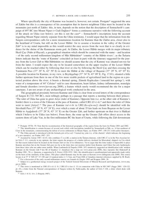
17. BETWEEN A ROCK AND A HARD PLACE 255 Where specifically the city of Kumme was located is, however, not certain. Postgate 86 suggested the area of Zakho but this is a consequence of his assumption that its known neighbour Ukku must be located in the mountains just north of Zakho: this, in turn, depends on the notion that the description of Sennacherib’s campaign of 697 BC into Mount Nipur (= Cudi Dagları) 87 forms a continuous narrative with the following account of the attack on Ukku (see below); yet this is not the case 88 – Sennacherib’s inscriptions keep the account regarding Mount Nipur entirely separate from the Ukku testimony. I would argue that the information from the Sargon correspondence calls for a more mountainous location for Kumme than the Zakho area, closer also to the heartland of Urartu, but still on the Lesser Habur: for to assume a location in the valley of the Greater Zab 89 is to my mind impossible as this would restrict the easy access from the west that is so clearly in evidence for the shrine of the Kummean storm god. At Zakho, the Lesser Habur merges with its major tributary Hezil Çay (Nahr al-Hayzal), a geographical situation which should be connected with the name – and location – of the early second millennium kingdom of Mat Haburatim 90 ‘country of the Habur rivers’; as the Susarra letters indicate that the ‘route of Kumme’ coincided (at least in part) with the itinerary suggested for the journey from the Lower Zab to Mat Haburatim we should assume that the city of Kumme was situated not too far from the latter. I would expect the city to be located somewhere on the upper reaches of the Lesser Habur which can be reached either by following that river or else by following the Hezil Çay and then crossing the Tanintanin Pass (37° 29b N, 42° 59b E) to meet the Habur at the village of Ba≥aran (37° 29b N, 43° 07b E). A possible location for Kumme, in my view, is Beytü≥≥ebap (37° 34b N, 43° 09b E; Fig. 17.01), situated a little further upstream from there in one of the few more sizable pockets of agricultural land in the region on a protected position above the river; it boasts a thermal spring, Zümrüt Kaplıcaları (‘emerald hot springs’), with water of a temperature of 44° Celsius 91 said to cure rheumatism, heart failure, kidney inflammation, neuralgia and female disorders (www.kevser.org 2008), a feature which surely would recommend the site for a major sanctuary. I am not aware of any archaeological work conducted in the area. The geographical proximity between Kumme und Ukku is clear from several letters of the correspondence of Sargon II (721-705 BC), most tellingly perhaps in a passage that reports a meeting between their princes: ‘The ruler of Ukku has gone to greet Ariye (ruler of Kumme). Opposite him (i.e. at the other side of Kumme’s border) there is a town of the Ukkeans at the pass of Kumme, called URU.El-iz-ki, 92 and there the ruler of Ukku went to meet [Ariye]’. 93 The pass of Kumme (né-ri-bi sa URU.Ku-u[m-me]) should be identified with the Süvrihalil Pass (37° 30b N, 43° 24b E), over which a route of about 35 km leads on from Ba≥aran on the Lesser Habur to A≥agıdereli (37° 28b N, 43° 31b E) on the Greater Zab, and further upstream on that river is Hakkari which I believe to be Ukku (see below). From there, the route up the Greater Zab offers direct access to the eastern shore of Lake Van, in the first millennium BC the heart of Urartu, while following the Zab downstream 86 Postgate 1973b: 59. Note that his reconstruction of the historical geography of the region forms the basis for Parker 2001 and 2002. 87 This identification is certain because of several rock reliefs with inscriptions installed by Sennacherib at Sah, ca. 14 km northeast of Cizre in the mountains, commemorating the defeat of seven settlements in Mount Nipur, see Frahm 1997: 150-151 (with earlier literature). 88 The Ukku episode is introduced with the formula pan niriya uter ‘I turned my yoke (i.e. of the chariot)’ which indicates the beginning of a new narrative; see Frahm 1997: 253. 89 Assumed by Astour 1987: 42-43, who combines Ú-ra-ú.KI, a station in the Susarra itinerary, with URU.Ú-ra in the Neo-Assyrian letter SAA 5 111, correctly in my opinion; the letter reports the progress of a timber delivery destined for Khorsabad, shipped via Ura which for that reason indeed must be located on the Greater Zab (or one of its tributaries). Yet to argue that this letter makes it impossible to place Kumme anywhere but on the Greater Zab goes too far as the letter does not mention timber from Kumme (and Ukku) but only lumberjacks from these cities who are rather more mobile. When Lanfranchi & Parpola (1990: 247) tentatively suggested an identification with ‘modern Komane on the Greater Zab 9 km SE of Imadiya’ [= Amadiya] (for a map see www.atour.com 2008), they repeated, like Diakonoff & Kashkai 1981: 70 s.v. Qumenu, a suggestion by E. Forrer (1928-1932: 268): this identification is unsubstantiated and apparently made solely on the basis of the similarity of the names. This place called Komane may be the same as Kuwani (www.fallingrain.com 2008). This source locates it at 37° 4b 56N 43° 31b 23E and 1.8 nautical miles (= 3.3 km, not 9 km) ESE of Amadiya (internet references supplied by M. Roaf). 90 For a discussion of the early second millennium sources see Joannès & Ziegler 1995 and Koppen 2004: 28. 91 Subject to a geothermal energy research project of the Turkish General Directorate of Mineral Research and Exploration, (www.mta. gov.tr 2008). 92 This town is mentioned as URU.El-iz-ki (l. 9) / URU.El-iz-kun (l. 13) in connection with Ukku in ND 2487 (Saggs 2001: 120-122, pl. 25), a letter from the Nimrud correspondence of Sargon written by Nabû-uÒalla, the author of SAA 5 104, a letter which deals with Kumme. 93 SAA 1 41 ll. 14-r. 2 (Parpola 1987).
256 KAREN RADNER brings the traveller to Shanidar, where we assume the border of Musasir to be, and from there via either the Kelishin or the Gawre Shinke Pass to the shores of Lake Urmia or else on to Arbail and the heart of Assyria. Despite the apparent remoteness of these locations, then, they are very well connected to the trans regional road network; that AriÒa of Kumme can supply carnelian stone to the Assyrians is perhaps a testament of this. 94 For more than a millennium, the temple of the storm god of Kumme can be shown to have ranked high among the most important Near Eastern sanctuaries. Already in the 18th century BC, he was invoked in a treaty 95 between Zimri-Lim of Mari and the ruler of Kurdâ, a kingdom situated in the Jebel Sinjar; Zimri-Lim also dedicated a precious vase to the temple of the storm god at Kumme. 96 The prominence of deity and shrine may have been a reason why Kumme retained its sovereignty during the time of the Assyrian empire: the storm god of Kumme was also revered at the city of Assur, 97 and Adad-nerari II (911-891 BC) visited his shrine to perform sacrifices in 895, calling the deity d IM sá URU.Ku-um-me EN-ia ‘the storm god of Kumme, my lord’ 98 – one of the relatively few mentions of an Assyrian king honouring a deity while on campaign and an appellation that emphasises an existing close relationship. The visit to Kumme was combined with the attempt to intimidate the surrounding region, called ‘the cities of Habhu, enemies of Kumme’, into paying tribute to the Assyrians in the form of horses yet as these payments did not materialise in the following year, Kumme was visited for a second time and the cities URU.Sa-at-ku-ri, URU.Ia ? -sa-ad-du, URU.Ku-un-nu and URU.Tap-si-a were destroyed, 99 the last also known from the inscriptions of Tiglath-pileser III (745-727 BC) as a ‘fortress of Urartu’ in or near the land of Ullubu 100 – the region on the Lesser Habur north of Dohuk, 101 previously known as Mat Haburatim – which was annexed to Assyria in 739. 102 It may be assumed that the extraction of tribute was the main reason for Adad-nerari’s call on Kumme but it is important to note that both occasions were presented as visits ‘to the assistance of the city of Kumme’. The relationship between Assyria and Kumme appears cordial during the reign of Assurnasirpal II (883-859 BC) who entertained delegates from Kumme – as well as Musasir, as we have seen – among the foreign notables at the inauguration of his new residence city, 103 and also afterwards visitors from Kumme would seem to be not unusual in Kalhu: in 797 BC, we find a man from Kumme acting as a witness for a transaction authorized by the governor of Kalhu. 104 This man may perhaps have fled his native city, as at around that time Minua of Urartu (c. 810-785 BC) was able to establish control over, inter alia, Uliba and Qumenu (which correspond to the Assyrian place names Ulluba and Kumme), ‘as far as Assyria’, 105 the invasion is likely to have caused some of the inhabitants to take refuge in Assyria. Minua’s claims are indirectly confirmed by the fact that in Tiglath-pileser’s official reports on the annexation of Ulluba in 739, several settlements – two of which are near Kumme (the already mentioned Tapsia and Babutta, see below) – are designated as Urartian fortresses. But already during the reign of Minua’s father Ispuini, Kumme is attested in a prominent role, for the inscription of Meher Kapısı near Van lists the sacrifices due to the ‘god of the people of Qumenu (Kumme)’ after the ‘god of the people of Ardini (MuÒaÒir)’ and the ‘god of the people of uspa (uruspa)’. 106 Yet the best documentation for Kumme dates to the reign of Sargon II when it is frequently mentioned in the royal correspondence 107 while references from the official inscriptions are entirely lacking. At that time, 94 SAA 5 284. 95 d Joannès 1991: 176-177 M. 7750 l. 4’ IM be-el Ku-um-mi-im.KI; cf. Schwemer 2001: 301-302 and Mayer 2002: 330. 96 d Guichard 2005: 438 no. 133 (= ARM VII 219) 7 IM sa Ku-um-mé. 97 d Mentioned in the so-called Götteradressbuch, l. 115 IM sá Ku-me (Menzel 1981: II T 154). 98 Grayson 1991: 152 A.0.99.2 ll. 91-93. 99 Grayson 1991: 152 A.0.99.2 ll. 94-96. 100 Tadmor 1994: 126-127 Summary Inscription 1: 27-28; 182-183 Summary Inscription 9 l. 12’. 101 The region can be located due to the rock relief at Milla Mergi, see Postgate 1973b: 57. 102 Radner 2006: 56-57 no. 40. 103 Grayson 1991: 293 A.0.101.30 l. 147 KUR.Ku-ma-a-a. 104 PN CTN 2 91 r. 18 Lid-bu-bu sa URU.Ku-me (Postgate 1973a). 105 König 1955-1957: 58-59 HchI 16 (CTU A 5-9 upper side: l. 10 KUR.Ú-li-ba-a-ni; l. 19 URU.Qu-me-nu-ú-ni pa-ri KUR.A-sú-ri-i-ni). See the discussion by Salvini 1995: 51. 106 König 1955-1957: 51 HchI 10 (CTU A 3-1 l. 55, URU.Qu-me-nu-na-ú-e DINGIR); cf. Salvini 1986: 32 who argued that the Urartian god Teiseba corresponds or at least was associated to Tessub of Kumme. 107 SAA 1 29, 41, 46, 233; SAA 5 94-95, 97-98, 100-102, 104-107, 117; SAA 15 284 (= Fuchs & Parpola 2001).
- Page 1 and 2: BIAINILI-URARTU The Proceedings of
- Page 3 and 4: VI TABLE OF CONTENTS 20 ALTAN ÇILI
- Page 5 and 6: 244 KAREN RADNER Fig. 17.01. Map sh
- Page 7 and 8: 246 KAREN RADNER which is known fro
- Page 9 and 10: 248 KAREN RADNER location to the we
- Page 11 and 12: 250 KAREN RADNER The area is also a
- Page 13 and 14: 252 KAREN RADNER (modern Tell Shems
- Page 15: 254 KAREN RADNER also to the Assyri
- Page 19 and 20: 258 KAREN RADNER - marked ‘3’ i
- Page 21 and 22: 260 KAREN RADNER the Urartian borde
- Page 23 and 24: 262 KAREN RADNER campaign into the
- Page 25 and 26: 264 KAREN RADNER Shalmaneser III of
- Page 27 and 28: 452 BIAINILI-URARTU Sg 8 Sargon’s
- Page 29 and 30: 454 BIAINILI-URARTU AVETISJAN, G.G.
- Page 31 and 32: 456 BIAINILI-URARTU BARNETT, R.D.,
- Page 33 and 34: 458 BIAINILI-URARTU BOEHMER, R.M. 1
- Page 35 and 36: 460 BIAINILI-URARTU CHACATRJAN, T.S
- Page 37 and 38: 462 BIAINILI-URARTU CURTIS, J.E. &
- Page 39 and 40: 464 BIAINILI-URARTU DJAPARIDZE, O.
- Page 41 and 42: 466 BIAINILI-URARTU FORRER, E. 1928
- Page 43 and 44: 468 BIAINILI-URARTU GILPIN, J. 2004
- Page 45 and 46: 470 BIAINILI-URARTU HAROUTIOUNIAN,
- Page 47 and 48: 472 BIAINILI-URARTU HOVHANNISSIAN,
- Page 49 and 50: 474 BIAINILI-URARTU KHATCHADOURIAN,
- Page 51 and 52: 476 BIAINILI-URARTU KOSSACK, G. 198
- Page 53 and 54: 478 BIAINILI-URARTU LEBEDYNSKY, I.
- Page 55 and 56: 480 BIAINILI-URARTU MARR, N. & ORBE
- Page 57 and 58: 482 BIAINILI-URARTU MILLARD, A.R. 1
- Page 59 and 60: 484 BIAINILI-URARTU ÖGÜN, B. (con
- Page 61 and 62: 486 BIAINILI-URARTU PIOTROVSKIJ, B.
- Page 63 and 64: 488 BIAINILI-URARTU RIEDERER, J. (c
- Page 65 and 66: 490 BIAINILI-URARTU SAJJADI, S.M. 2
17. BETWEEN A ROCK AND A HARD PLACE 255<br />
Where specifically the city <strong>of</strong> Kumme was located is, however, not certain. Postgate 86 suggested the area<br />
<strong>of</strong> Zakho but this is a consequence <strong>of</strong> his assumption that its known neighbour Ukku must be located in the<br />
mountains just north <strong>of</strong> Zakho: this, in turn, depends on the notion that the description <strong>of</strong> Sennacherib’s campaign<br />
<strong>of</strong> 697 BC into Mount Nipur (= Cudi Dagları) 87 forms a continuous narrative with the following account<br />
<strong>of</strong> the attack on Ukku (see below); yet this is not the case 88 – Sennacherib’s inscriptions keep the account<br />
regarding Mount Nipur entirely separate from the Ukku testimony. I would argue that the information from the<br />
Sargon correspondence calls for a more mountainous location for Kumme than the Zakho area, closer also to<br />
the heartland <strong>of</strong> Urartu, but still on the Lesser Habur: for to assume a location in the valley <strong>of</strong> the Greater<br />
Zab 89 is to my mind impossible as this would restrict the easy access from the west that is so clearly in evidence<br />
for the shrine <strong>of</strong> the Kummean storm god. At Zakho, the Lesser Habur merges with its major tributary<br />
Hezil Çay (Nahr al-Hayzal), a geographical situation which should be connected with the name – and location<br />
– <strong>of</strong> the early second millennium kingdom <strong>of</strong> Mat Haburatim 90 ‘country <strong>of</strong> the Habur rivers’; as the Susarra<br />
letters indicate that the ‘route <strong>of</strong> Kumme’ coincided (at least in part) with the itinerary suggested for the journey<br />
from the Lower Zab to Mat Haburatim we should assume that the city <strong>of</strong> Kumme was situated not too far<br />
from the latter. I would expect the city to be located somewhere on the upper reaches <strong>of</strong> the Lesser Habur<br />
which can be reached either by following that river or else by following the Hezil Çay and then crossing the<br />
Tanintanin Pass (37° 29b N, 42° 59b E) to meet the Habur at the village <strong>of</strong> Ba≥aran (37° 29b N, 43° 07b E).<br />
A possible location for Kumme, in my view, is Beytü≥≥ebap (37° 34b N, 43° 09b E; Fig. 17.01), situated a little<br />
further upstream from there in one <strong>of</strong> the few more sizable pockets <strong>of</strong> agricultural land in the region on a protected<br />
position above the river; it boasts a thermal spring, Zümrüt Kaplıcaları (‘emerald hot springs’), with<br />
water <strong>of</strong> a temperature <strong>of</strong> 44° Celsius 91 said to cure rheumatism, heart failure, kidney inflammation, neuralgia<br />
and female disorders (www.kevser.org 2008), a feature which surely would recommend the site for a major<br />
sanctuary. I am not aware <strong>of</strong> any archaeological work conducted in the area.<br />
The geographical proximity between Kumme und Ukku is clear from several letters <strong>of</strong> the correspondence<br />
<strong>of</strong> Sargon II (721-705 BC), most tellingly perhaps in a passage that reports a meeting between their princes:<br />
‘The ruler <strong>of</strong> Ukku has gone to greet Ariye (ruler <strong>of</strong> Kumme). Opposite him (i.e. at the other side <strong>of</strong> Kumme’s<br />
border) there is a town <strong>of</strong> the Ukkeans at the pass <strong>of</strong> Kumme, called URU.El-iz-ki, 92 and there the ruler <strong>of</strong> Ukku<br />
went to meet [Ariye]’. 93 The pass <strong>of</strong> Kumme (né-ri-bi sa URU.Ku-u[m-me]) should be identified with the<br />
Süvrihalil Pass (37° 30b N, 43° 24b E), over which a route <strong>of</strong> about 35 km leads on from Ba≥aran on the Lesser<br />
Habur to A≥agıdereli (37° 28b N, 43° 31b E) on the Greater Zab, and further upstream on that river is Hakkari<br />
which I believe to be Ukku (see below). From there, the route up the Greater Zab <strong>of</strong>fers direct access to the<br />
eastern shore <strong>of</strong> Lake Van, in the first millennium BC the heart <strong>of</strong> Urartu, while following the Zab downstream<br />
86 Postgate 1973b: 59. Note that his reconstruction <strong>of</strong> the historical geography <strong>of</strong> the region forms the basis for Parker 2001 and 2002.<br />
87 This identification is certain because <strong>of</strong> several rock reliefs with inscriptions installed by Sennacherib at Sah, ca. 14 km northeast <strong>of</strong><br />
Cizre in the mountains, commemorating the defeat <strong>of</strong> seven settlements in Mount Nipur, see Frahm 1997: 150-151 (with earlier literature).<br />
88 The Ukku episode is introduced with the formula pan niriya uter ‘I turned my yoke (i.e. <strong>of</strong> the chariot)’ which indicates the beginning<br />
<strong>of</strong> a new narrative; see Frahm 1997: 253.<br />
89 Assumed by Astour 1987: 42-43, who combines Ú-ra-ú.KI, a station in the Susarra itinerary, with URU.Ú-ra in the Neo-Assyrian letter<br />
SAA 5 111, correctly in my opinion; the letter reports the progress <strong>of</strong> a timber delivery destined for Khorsabad, shipped via Ura which<br />
for that reason indeed must be located on the Greater Zab (or one <strong>of</strong> its tributaries). Yet to argue that this letter makes it impossible to place<br />
Kumme anywhere but on the Greater Zab goes too far as the letter does not mention timber from Kumme (and Ukku) but only lumberjacks<br />
from these cities who are rather more mobile. When Lanfranchi & Parpola (1990: 247) tentatively suggested an identification with ‘modern<br />
Komane on the Greater Zab 9 km SE <strong>of</strong> Imadiya’ [= Amadiya] (for a map see www.atour.com 2008), they repeated, like Diakon<strong>of</strong>f &<br />
Kashkai 1981: 70 s.v. Qumenu, a suggestion by E. Forrer (1928-1932: 268): this identification is unsubstantiated and apparently made solely<br />
on the basis <strong>of</strong> the similarity <strong>of</strong> the names. This place called Komane may be the same as Kuwani (www.fallingrain.com 2008). This source<br />
locates it at 37° 4b 56N 43° 31b 23E and 1.8 nautical miles (= 3.3 km, not 9 km) ESE <strong>of</strong> Amadiya (internet references supplied by M. Roaf).<br />
90 For a discussion <strong>of</strong> the early second millennium sources see Joannès & Ziegler 1995 and Koppen 2004: 28.<br />
91 Subject to a geothermal energy research project <strong>of</strong> the Turkish General Directorate <strong>of</strong> Mineral Research and Exploration, (www.mta.<br />
gov.tr 2008).<br />
92 This town is mentioned as URU.El-iz-ki (l. 9) / URU.El-iz-kun (l. 13) in connection with Ukku in ND 2487 (Saggs 2001: 120-122,<br />
pl. 25), a letter from the Nimrud correspondence <strong>of</strong> Sargon written by Nabû-uÒalla, the author <strong>of</strong> SAA 5 104, a letter which deals with<br />
Kumme.<br />
93 SAA 1 41 ll. 14-r. 2 (Parpola 1987).


