Preprint volume - SIBM
Preprint volume - SIBM Preprint volume - SIBM
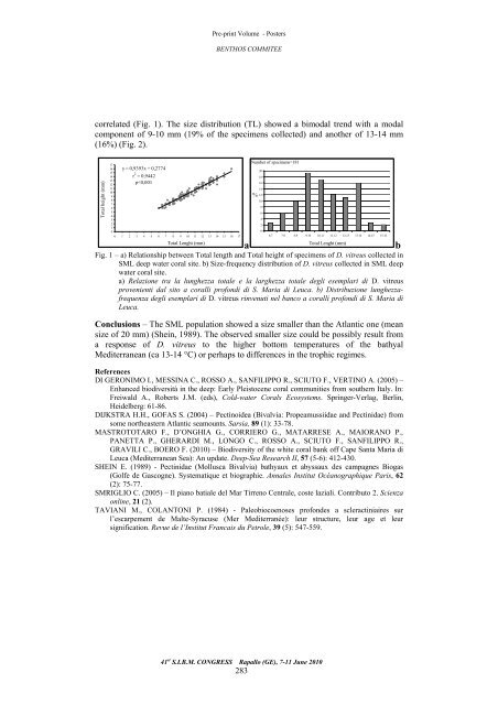
Pre-print Volume - Posters BENTHOS COMMITEE correlated (Fig. 1). The size distribution (TL) showed a bimodal trend with a modal component of 9-10 mm (19% of the specimens collected) and another of 13-14 mm (16%) (Fig. 2). Total height (mm) y = 0,9393x + 0,2774 r 2 17 16 15 14 = 0,9442 13 12 11 10 9 8 7 6 5 4 3 2 1 0 p
Pre-print Volume - Posters BENTHOS COMMITEE E. PORPORATO, M.C. MANGANO, F. DE DOMENICO, N. SPANÒ Dip.to di Biologia Animale ed Ecologia Marina, Università di Messina, Salita Sperone, 31 - 98166 Messina, Italia. eporporato@unime.it DISTRIBUTION OF THE MAIN BIOCENOTIC COMPONENTS OF THE GIARDINI NAXOS GULF (MEDITERRANEAN SEA) DISTRIBUZIONE DELLE PRINCIPALI COMPONENTI BIOCENOTICHE NEL GOLFO DI GIARDINI NAXOS (MAR MEDITERRANEO) Abstract – In this paper the biocenotic map of the Giardini Naxos Gulf and its nearby (Strait of Messina) is reported. Data were collected using exclusively non-destructive sampling methods. A heterogeneous area probably due to the interaction of a lot of factors was highlighted. Key-words: biocoenoses, benthos, GIS, Side Scan Sonar. Introduction – The distribution of the main marine biocoenoses can play a fundamental role in the conservation, monitoring and management of the coastal marine environment (Somaschini et al., 1998; Diviacco et al., 2000; Piazzi et al., 2000). In these contexts, the possibility to draw a bionomical map using non destructive sampling methods is to considered preferable. This paper provides a bionomical map of the benthic communities from the Giardini Naxos Gulf (Strait of Messina). Materials and methods – The survey was carried out in the Giardini Naxos Gulf and its nearby (Strait of Messina, Mediterranean Sea) from 2 to 183 m of depth in the framework of a regional project (SFOP 2004 - POR 2000-2006). Data were collected by Side Scan Sonar (SSS) and by direct and indirect Visual census methods (Scuba diving, ROV) and were put into a GIS to produce the cartography of the area. Results – A map at 1:20.000 scales of the investigated area, reporting the main biocenotic features, was produced (Fig. 1). The most part of the area consisted of soft bottoms, mainly represented by muddy biodetritic bottoms (DE, Pérès and Picard, 1964), most abundant off the Gulf and at the deeper depths, and by SFBC biocoenoses (sensu Pérès and Picard, 1964), well-represented into the Gulf, within 50 m of depth. As shown in the figure, zones characterized by AP-HP, PE and VTC biocoenoses (sensu Pérès and Picard, 1964) were also observed. Furthermore, the presence of wide local aggregations of Pennatulaceans, Cidarids and Ditrupa arietina (O.F. Müller, 1776) (Annelida: Polychaeta) was recorded. Conclusions – The studied area appeared considerably heterogeneous probably as a consequence of the interaction of a lot of factors. In fact, the area is affected by strong bottom currents, irregular continental input and abundant suspended particles captured by suspension feeders which locally can reach high biomasses, as also witnessed by the pennatulacean aggregations (AA.VV., 2007). 41 st S.I.B.M. CONGRESS Rapallo (GE), 7-11 June 2010 284
- Page 234 and 235: Pre-print Volume -Posters Topic 4:
- Page 236 and 237: Pre-print Volume -Posters Topic 4:
- Page 238 and 239: Pre-print Volume -Posters Topic 4:
- Page 240 and 241: Pre-print Volume - Posters AQUACULT
- Page 242 and 243: Pre-print Volume - Posters AQUACULT
- Page 244 and 245: Pre-print Volume - Posters AQUACULT
- Page 246 and 247: Pre-print Volume - Posters AQUACULT
- Page 248 and 249: Pre-print Volume - Posters AQUACULT
- Page 250 and 251: Pre-print Volume - Posters AQUACULT
- Page 252 and 253: Pre-print Volume - Posters AQUACULT
- Page 254 and 255: Pre-print Volume - Posters AQUACULT
- Page 256 and 257: Pre-print Volume - Posters AQUACULT
- Page 258 and 259: Pre-print Volume BENTHOS COMMITEE B
- Page 260 and 261: Pre-print Volume - Posters BENTHOS
- Page 262 and 263: Pre-print Volume - Posters BENTHOS
- Page 264 and 265: Pre-print Volume - Posters BENTHOS
- Page 266 and 267: Pre-print Volume - Posters BENTHOS
- Page 268 and 269: Pre-print Volume - Posters BENTHOS
- Page 270 and 271: Pre-print Volume - Posters BENTHOS
- Page 272 and 273: Pre-print Volume - Posters BENTHOS
- Page 274 and 275: Pre-print Volume - Posters BENTHOS
- Page 276 and 277: Pre-print Volume - Posters BENTHOS
- Page 278 and 279: Pre-print Volume - Posters BENTHOS
- Page 280 and 281: Pre-print Volume - Posters BENTHOS
- Page 282 and 283: Pre-print Volume - Posters BENTHOS
- Page 286 and 287: Pre-print Volume - Posters BENTHOS
- Page 288 and 289: Pre-print Volume - Posters BENTHOS
- Page 290 and 291: Pre-print Volume - Posters MANAGEME
- Page 292 and 293: Pre-print Volume - Posters MANAGEME
- Page 294 and 295: Pre-print Volume - Posters MANAGEME
- Page 296 and 297: Pre-print Volume - Posters MANAGEME
- Page 298 and 299: Pre-print Volume - Posters MANAGEME
- Page 300 and 301: Pre-print Volume - Posters MANAGEME
- Page 302 and 303: Pre-print Volume - Posters MANAGEME
- Page 304 and 305: Pre-print Volume - Posters MANAGEME
- Page 306 and 307: Pre-print Volume NECTON AND FISHERY
- Page 308 and 309: Pre-print Volume -Posters NECTON AN
- Page 310 and 311: Pre-print Volume -Posters NECTON AN
- Page 312 and 313: Pre-print Volume -Posters NECTON AN
- Page 314 and 315: Pre-print Volume -Posters NECTON AN
- Page 316 and 317: Pre-print Volume -Posters NECTON AN
- Page 318 and 319: Pre-print Volume -Posters NECTON AN
- Page 320 and 321: Pre-print Volume -Posters NECTON AN
- Page 322 and 323: Pre-print Volume -Posters NECTON AN
- Page 324 and 325: Pre-print Volume -Posters NECTON AN
- Page 326 and 327: Pre-print Volume -Posters NECTON AN
- Page 328 and 329: Pre-print Volume -Posters NECTON AN
- Page 330 and 331: Pre-print Volume -Posters NECTON AN
- Page 332 and 333: Pre-print Volume -Posters NECTON AN
Pre-print Volume - Posters<br />
BENTHOS COMMITEE<br />
correlated (Fig. 1). The size distribution (TL) showed a bimodal trend with a modal<br />
component of 9-10 mm (19% of the specimens collected) and another of 13-14 mm<br />
(16%) (Fig. 2).<br />
Total height (mm)<br />
y = 0,9393x + 0,2774<br />
r 2 17<br />
16<br />
15<br />
14 = 0,9442<br />
13<br />
12<br />
11<br />
10<br />
9<br />
8<br />
7<br />
6<br />
5<br />
4<br />
3<br />
2<br />
1<br />
0<br />
p


