06-bioresourcesstatu.. - M. S. Swaminathan Research Foundation
06-bioresourcesstatu.. - M. S. Swaminathan Research Foundation
06-bioresourcesstatu.. - M. S. Swaminathan Research Foundation

You also want an ePaper? Increase the reach of your titles
YUMPU automatically turns print PDFs into web optimized ePapers that Google loves.
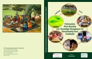
Malvan<br />
REGIONAL PLAN<br />
RATNAGIRI - SINDHUDURG RESOURCE REGION.<br />
LOCATION<br />
RATNAGIRI-SINDHUDURG REGIONAL PLANNING BOARD<br />
II. Description of Site<br />
i. Location<br />
Malvan is situated 16°04'N latitude and 73°28'E<br />
longitude on the West coast of Maharashtra. It is<br />
a Tahsil place in Sindhudurg district. The former<br />
Ratnagiri district was split into two, the south<br />
part was named Sindhudurg district. The district<br />
boundary is to the north of Deogad (Map: 1). The<br />
district marks southern boundary of state of<br />
Maharashtra. Malvan is one of the 7 tahsils in<br />
Sindhudurg district. It covers the area of 663.3 sq.<br />
km. The number of villages under the tahsil is 136;<br />
in addition there are 772 "wadis'.<br />
ii. Climate<br />
Malvan experiences three well-defined seasons<br />
i.e. summer (Feb-May), rainy (June-Oct) and<br />
winter (Nov-Jan).<br />
The mean annual rainfall is 1997 mm. The<br />
maximum rain days occur in June. Total no. of<br />
rainy days are 1<strong>06</strong>with maximum rainfall ranging<br />
from 960-2500mm. October is the month with low<br />
rainfall.<br />
iii. Soils and topography<br />
The chief rock types are basalt, granite and<br />
gneisses. The soil is lateritic. The tahsil is typical<br />
of Konkan region having a narrow belt of coastline<br />
and non-deltaic seaboard. The rivers are short<br />
course and rushing, ending in small estuary,<br />
finally joining the Arabian Sea. The Western Ghats<br />
from the eastern boundary of the tahsil. The tahsil<br />
is limited in the north by Achara river and the<br />
south boundary is another river, Karli. There are<br />
two more rivers in the tahsil, Kolamb and<br />
Kalavali. These rivers form tidal swamps and<br />
support mangrove vegetation.<br />
iv. Vegetation and animal life<br />
More than 30 mangrove species have been<br />
recorded from region during several visits of the<br />
investigator. The most important species of<br />
mangroves, which is critically endangered,<br />
Xylocarpus granatum, is recorded by the author<br />
from Malvan tahsil (Bhosale et. aI., 2000).<br />
At least 20 species of edible fish from estuaries are<br />
recorded from the tahsil. The corals are found<br />
around Malvan. Its seaweed flora is very rich. The<br />
fauna is equally rich hence Marine park is<br />
proposed (Map 2). There are about 100 species of<br />
avifauna. About 10 species of reptile and 10<br />
species of mammals (Kavinde, 1997, BCPP Final<br />
Report).<br />
In addition Western Ghat region of Malvan<br />
supports medicinal plants, the list includes about<br />
124 species (Annexure I) as per the research data,<br />
collected by Dr. Yadav of Botany Department of<br />
Shivaji University, Kolhapur.<br />
III. Population Profile<br />
The provisional population totals are available on<br />
the basis of 2001 census are given below:<br />
Table 1 : Population Profile of District and Tahsil<br />
Total Population<br />
Males<br />
Females<br />
SindhudurgDistrict Malvan Tahsil<br />
8,61,672<br />
4,14,900<br />
4.46,772<br />
Source: Provisional Population TOtals<br />
Maharastra 200.1 Census<br />
1,16,091<br />
95,777<br />
6,314<br />
The population figure is higher than the year 1991<br />
by 3.55%, in 1991 it was 6.56% higher than<br />
previous census.<br />
The sex ratio (number of females per 1000males)<br />
was 1137 in 1991 which is now 1077.<br />
64