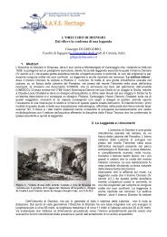
Archaeology and nature: hyblean cultural landscape and territorial ...
Archaeology and nature: hyblean cultural landscape and territorial ...
Archaeology and nature: hyblean cultural landscape and territorial ...

Create successful ePaper yourself
Turn your PDF publications into a flip-book with our unique Google optimized e-Paper software.
Shape:<br />
1. Bridge dimensions <strong>and</strong> shape: Either in the overpasses <strong>and</strong> in the bridges, is it necessary to keep a<br />
reduced deck dimension in order to minimize the visual impacts? Has the bridge typology been studied<br />
together with construction techniques which allows a drawing able to keep a reduced deck dimension?<br />
2. Context shapes: Does the bridge/road take into account the functions <strong>and</strong> shapes of its surroundings? Is<br />
it in connection with them?<br />
3. Visibility of the infrastructure <strong>and</strong> by the infrastructure: Have the various alternatives been evaluated<br />
about the bridge/street positioning in relation to its view from the bridge/street <strong>and</strong> of the bridge/street? Can<br />
the bridge/street offer optical cones towards worthy l<strong>and</strong>scapes <strong>and</strong> at the same time conceal the view of the<br />
traffic?<br />
4. Formal coherence between the product <strong>and</strong> the context: Is it necessary that the bridge/street drawing<br />
follow a formal coherence with the other elements of the territory?<br />
5. Lighting: How does the bridge/street work at night? Is there any lighting which shows its presence,<br />
enhancing its shapes? Does the night lighting give a formal result which is coherent with the day-time view?<br />
6. Vehicular traffic view: Is it necessary to conceal the traffic view of a bridge/street?<br />
Function<br />
1. Flexibility: In the future, can the bridge/street be enlarged in order to achieve new traffic needs?<br />
2. Economical contest: Does the bridge/street take into account the economic development of its<br />
surroundings?<br />
3. Interchange: In the network nearness, is it possible to exchange the various transport ways?<br />
4. General economy: Is the working of a road infrastructure compatible with the structural needs of the<br />
population budget?<br />
5. Interdisciplinary program: Do the program documents grasp the potential <strong>and</strong> vulnerability of the territory<br />
functions, shapes <strong>and</strong> meaning both on a great extent <strong>and</strong> on a local rank?<br />
6. Traffic category: Does the bridge/street take into account the different traffic categories?<br />
7. Functional intersections: Which functions do the bridge/street seize? For instance, if in the nearness of<br />
the bridge there is the possibility to create a park, can the bridge have functional relations?<br />
Meaning<br />
1. Characterization: can the succession of overpasses with similar features be the expression of the<br />
stereotyping of a road?<br />
2. Identity: Which images of the territory are possible after the infrastructural intervention? Which territory’s<br />
identity is possible after the infrastructural intervention?<br />
3. The symbol: Does the bridge/road have a symbolic value?<br />
4. Renovation: can a bridge/street renovate places?<br />
5. Doorway/access/transit: can a bridge/street express, where it is necessary, the access to a town? Or as<br />
the crossing of a place?<br />
6. Limit: can a bridge/street be a geographic reference point which marks the crossing from a territory to<br />
another?<br />
7. Grades: Are there any recognizable functions in which the bridge/street is in connection with? Which<br />
grade of function is recognizable?<br />
8. The old <strong>and</strong> the new: in case of a functional adaptation of an old bridge/street, are there any rules which<br />
regulate the old <strong>and</strong> modern relations? Will the intervention be on both sides or on only one? Will a<br />
reversible technology be used? Will there be a hierarchy to highlight?<br />
4. Results<br />
The infrastructural road plan can be the chance to create a conceptual quality which is able to establish a<br />
relationship between the functions, shapes, <strong>and</strong> meaning of the road/bridge <strong>and</strong> the functions of the context.<br />
Supposing to define the “conceptual quality of the infrastructural roads as a whole of value added deduced<br />
from the connection of components within the plan <strong>and</strong> the <strong>territorial</strong> context that enables the project to<br />
satisfy a series of requirements not directly requested by the performance goal” [2], it st<strong>and</strong>s to reason that<br />
the conceptual quality can differ in many ways <strong>and</strong> can be expressed through a multiplicity of meanings. The<br />
followings are to be underlined.<br />
The determination of a conceptual quality is a <strong>cultural</strong> fact.<br />
The conceptual quality of a road infrastructure is the result of the communication between the client <strong>and</strong> the<br />
designer; it is territory knowledge; it is multidisciplinary or better trans-disciplinary, as it follows a process of<br />
mutual exchange <strong>and</strong> of mutual enrichment between the designer <strong>and</strong> the client as well as it tries to catch<br />
the population requests. The infrastructure, characterized by a higher grade of conceptual quality, will be<br />
1134