

Geological Survey of Finland, Special Paper 46 - arkisto.gsf.fi
Geological Survey of Finland, Special Paper 46 - arkisto.gsf.fi
Geological Survey of Finland, Special Paper 46 - arkisto.gsf.fi

You also want an ePaper? Increase the reach of your titles
YUMPU automatically turns print PDFs into web optimized ePapers that Google loves.
<strong>Geological</strong> <strong>Survey</strong> <strong>of</strong> <strong>Finland</strong>, <strong>Special</strong> <strong>Paper</strong> <strong>46</strong><br />
Volli Kalm<br />
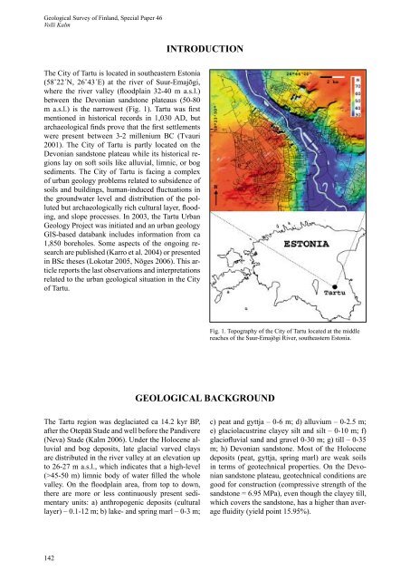
The City <strong>of</strong> Tartu is located in southeastern Estonia<br />
(58˚22´N, 26˚43´E) at the river <strong>of</strong> Suur-Emajõgi,<br />
where the river valley (fl oodplain 32-40 m a.s.l.)<br />
between the Devonian sandstone plateaus (50-80<br />
m a.s.l.) is the narrowest (Fig. 1). Tartu was <strong>fi</strong> rst<br />
mentioned in historical records in 1,030 AD, but<br />
archaeological <strong>fi</strong> nds prove that the <strong>fi</strong> rst settlements<br />
were present between 3-2 millenium BC (Tvauri<br />
2001). The City <strong>of</strong> Tartu is partly located on the<br />
Devonian sandstone plateau while its historical regions<br />
lay on s<strong>of</strong>t soils like alluvial, limnic, or bog<br />
sediments. The City <strong>of</strong> Tartu is facing a complex<br />
<strong>of</strong> urban geology problems related to subsidence <strong>of</strong><br />
soils and buildings, human-induced fl uctuations in<br />
the groundwater level and distribution <strong>of</strong> the polluted<br />
but archaeologically rich cultural layer, fl ooding,<br />
and slope processes. In 2003, the Tartu Urban<br />
Geology Project was initiated and an urban geology<br />
GIS-based databank includes information from ca<br />
1,850 boreholes. Some aspects <strong>of</strong> the ongoing research<br />
are published (Karro et al. 2004) or presented<br />
in BSc theses (Lokotar 2005, Nõges 2006). This article<br />
reports the last observations and interpretations<br />
related to the urban geological situation in the City<br />
<strong>of</strong> Tartu.<br />
The Tartu region was deglaciated ca 14.2 kyr BP,<br />
after the Otepää Stade and well before the Pandivere<br />
(Neva) Stade (Kalm 2006). Under the Holocene alluvial<br />
and bog deposits, late glacial varved clays<br />
are distributed in the river valley at an elevation up<br />
to 26-27 m a.s.l., which indicates that a high-level<br />
(>45-50 m) limnic body <strong>of</strong> water <strong>fi</strong> lled the whole<br />
valley. On the fl oodplain area, from top to down,<br />
there are more or less continuously present sedimentary<br />
units: a) anthropogenic deposits (cultural<br />
layer) – 0.1-12 m; b) lake- and spring marl – 0-3 m;<br />
142<br />
INTRODUCTION<br />
GEOLOGICAL BACKGROUND<br />
Fig. 1. Topography <strong>of</strong> the City <strong>of</strong> Tartu located at the middle<br />
reaches <strong>of</strong> the Suur-Emajõgi River, southeastern Estonia.<br />
c) peat and gyttja – 0-6 m; d) alluvium – 0-2.5 m;<br />
e) glaciolacustrine clayey silt and silt – 0-10 m; f)<br />
glaci<strong>of</strong>l uvial sand and gravel 0-30 m; g) till – 0-35<br />
m; h) Devonian sandstone. Most <strong>of</strong> the Holocene<br />
deposits (peat, gyttja, spring marl) are weak soils<br />
in terms <strong>of</strong> geotechnical properties. On the Devonian<br />
sandstone plateau, geotechnical conditions are<br />
good for construction (compressive strength <strong>of</strong> the<br />
sandstone = 6.95 MPa), even though the clayey till,<br />
which covers the sandstone, has a higher than average<br />
fl uidity (yield point 15.95%).


