The Nanga Parbat-Haramosh Monitoring Network - IRSA - Cnr
The Nanga Parbat-Haramosh Monitoring Network - IRSA - Cnr
The Nanga Parbat-Haramosh Monitoring Network - IRSA - Cnr

Create successful ePaper yourself
Turn your PDF publications into a flip-book with our unique Google optimized e-Paper software.
Comparison between the Tectonic Movements of Mt. Everest<br />
and the <strong>Nanga</strong> <strong>Parbat</strong>-<strong>Haramosh</strong> Massif<br />
Giorgio Poretti (1) , Chiara Calligaris (2) , Shahina Tariq (3) , Hawas Khan (4)<br />
(1) University of Trieste, Italy – DMI, (2) University of Trieste, Italy – DiSGAM, (3) Bahria University, Pakistan - DE&ES<br />
(4) Karakorum International University, Gilgit – DES<br />
Introduction<br />
If the Himalayas are a land of extremes from the topographical, geophysical and<br />
geological point of view (Windley B.F., 1986), the Karakorum is a land of superlatives,<br />
having the highest concentration of mountains beyond 8000 metres, having the longest<br />
glaciers beyond the poles, being the source of one of the longest rivers. From the<br />
geophysical point of view it contains the largest gravity anomalies (G. Poretti, 1998) and<br />
thickness of the earth crust (75 km) (Finetti & al. 1979, 1983) and the highest values of<br />
deflection of the vertical.<br />
It contains also the highest relief (4000 metres from the Indus plains to the summit<br />
of <strong>Nanga</strong> <strong>Parbat</strong>). It seems also that this area is subject to the highest uplift. This has<br />
been mentioned by many authors deriving it through indirect methods, but not yet<br />
confirmed by accurate direct observations. Lewis Owen reports 0.7 mm/y using fissiontrack<br />
methods (L. A. Owen, 1989). Higher values (2 mm/y) are inferred by several<br />
researchers (Zeitler P., 1985; Gorniz & Seeber L. 1981; Lyon-Caen & Molnar P., 1983).<br />
Finally an average value of 6-10 mm/y was in the hypothesis of Zeitler & al. 1985 including<br />
uplift and erosion.<br />
1
<strong>The</strong> present study presents the preliminary results of a first survey consequent to<br />
the recent installation (2009) of GNSS network including three permanent GNSS stations<br />
between Islamabad and the Northern Areas of Pakistan and four points located on the<br />
<strong>Nanga</strong> <strong>Parbat</strong> – <strong>Haramosh</strong> massif.<br />
Since a permanent GPS station was located near the Pyramid Laboratory at<br />
Lobuche in the Khumbu region in 1994 providing long records of data during the last 15<br />
years, the goal of the project is to compare data obtained from Everest with the ones from<br />
<strong>Nanga</strong> <strong>Parbat</strong> in order to evaluate, not only the total uplift (if quantifiable) of the two<br />
massifs, but also the direction of the crustal movements.<br />
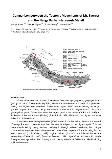
Regional Geology and Plate Tectonic Setting<br />
Northern Pakistan comprises three former distinct and previously apart plates<br />
named Karakoram, Kohistan and Indian. <strong>The</strong>se Plates collided with each other during<br />
Cretaceous-Tertiary ages and formed the present day configuration of this region<br />
(Tahirkheli et al., 1982; Coward et al., 1987). This collisional tectonics and mountainbuilding<br />
activity is termed Himalayan orgogeny being the result of continent-arc-continent<br />
collision. <strong>The</strong> Kohistan Island Arc is sutured to the Karakoram Block (Shyok Suture) in the<br />
north along MKT (Main Karakoram Thrust) and to the Indian Plate (Indus-Tsangpo Suture)<br />
in the south. <strong>The</strong> tectonics of Kohistan is related to collisional tectonics of Hindu Kush,<br />
Karakoram and Himalayan Ranges which involve Indian Plate with <strong>Nanga</strong> <strong>Parbat</strong>-<br />
<strong>Haramosh</strong> Massif, Karakoram Block and in between sandwiched Kohistan Arc.<br />
Geology of the <strong>Nanga</strong> <strong>Parbat</strong> area<br />
<strong>Nanga</strong> <strong>Parbat</strong>–<strong>Haramosh</strong> massif is delimitated by two thrust-displacement shear<br />
zones that have a spatial and temporal link with granite plutonism from ca. 10 to 1 Ma. <strong>The</strong><br />
shear zones define a crustal-scale antiformal pop-up structure, with dominant westnorthwest–vergent<br />
and subordinate east-southeast–vergent thrusting. This is substantially<br />
different than the surrounding area where the main exposed Himalayan structures are<br />
oriented parallel to the orogenic trend and are early to middle Miocene or older (Schneider<br />
et al., 1997). <strong>The</strong> western Himalaya syntaxis includes the <strong>Nanga</strong> <strong>Parbat</strong>–<strong>Haramosh</strong><br />
massif, a now exposed section of largely Proterozoic Indian plate crust, initially<br />
overthrusted by Cretaceous island arc rocks along the Main Mantle thrust. <strong>Nanga</strong> <strong>Parbat</strong> is<br />
an area of extreme relief that has undergone rapid exhumation since 10 Ma (e.g., Zeitler<br />
P., 1985), exposing migmatites and granulitegrade rocks at the core of the massif (Smith<br />
H.A. et al., 1992). <strong>Nanga</strong> <strong>Parbat</strong> syntaxis comprises three major rock units: a) Iskhere-<br />
Mushkin-Rupal Gneiss; b) Shengus-Harchu Gneiss; and <strong>Haramosh</strong>-Tarshing Schists. A<br />
wide range of rocks intruding these major lithological units has been noticed in nearly all of<br />
<strong>Nanga</strong> <strong>Parbat</strong> synaxial region, which included basic dykes and a wide variety of granites.<br />
<strong>The</strong> younger phases of granite up to 0.75 Ma are intruding the <strong>Nanga</strong> <strong>Parbat</strong> Gneisses.<br />
<strong>The</strong> survey of the Mt. Everest mountain range<br />
Fifteen years (unfortunately not continuous) of observations with a permanent GPS<br />
station at the Ev-K2-CNR Pyramid Laboratory allow to determine the precise direction of<br />
the tectonic movement of the Mt. Everest area. Taking into account several time intervals<br />
2
linking to the permanent GNSS station in Lhasa, the shift of the point was computed to be<br />
of 4.2-4.5 cm/year (Poretti G., 1998) to the North-East with an azimuth of approximately<br />
45°.<br />
A research project carried out between June 2009 and November 2010 is trying to<br />
find out the uplift and the direction of the movement of the <strong>Nanga</strong> <strong>Parbat</strong> area with the<br />
installation of three permanent GPS stations (Islamabad, Gilgit and Skardu) that will be remeasured<br />
every year for the next five years.<br />
Conclusions<br />
<strong>The</strong> aim of the project is to evaluate the variation in elevation and direction of the<br />
<strong>Nanga</strong> <strong>Parbat</strong> massif and to compare these results with those obtained from Everest in<br />
order to understand if their movements can be correlated in amount and direction. After<br />
only one year it is seems that the movement of the <strong>Nanga</strong> <strong>Parbat</strong> area is more bended to<br />
the East, but it is still too early to draw conclusions that are not within the margin of error of<br />
the instruments employed. More reliable results will be obtained from the repeated<br />
observations during the next 2-3 years.<br />
<strong>Nanga</strong> <strong>Parbat</strong> from the Rama Bungalow Mt. Everest from Rongbuck<br />
References<br />
1. Gansser, A., 1964. Geology of the Himalayas. Wiley Interscience, London. 289 p., & 4 plates.<br />
2. Finetti I., F. Giorgetti, G. Poretti, 1979, <strong>The</strong> Pakistani segment of the DSS Profile <strong>Nanga</strong> <strong>Parbat</strong>-Karakul (1974-<br />
1975). Bollettino di Geofisica Teorica e Applicata, v. XXI, n. 83, pp. 159-171.<br />
3. Seeber L. & V. Gormiz, 1981. River profiles along the Himalayan arc as indicators of active tectonics.<br />
Tectonophysics<br />
4. Tahirkheli, R. A., 1982. Geology of the Himalaya, Karakoram, Hindukush in Pakistan. Geol. Bull. Univ. Peshawar.<br />
5. Finetti I., G. Poretti, M. A. Mirza, 1983, Crustal Structure of the Karakorum Range along the DSS Profile <strong>Nanga</strong><br />
<strong>Parbat</strong>-Karakul. Bollettino di Geofisica Teorica e Applicata, v. XXV, n. 99-100, pp. 195-205.<br />
6. Ebblin C., A. Marussi, G. Poretti, M. Rahim, P. Richardus, 1983, Gravity Measurements in the Karakorum.<br />
Bollettino di Geofisica Teorica e Applicata, v. XXV, n. 99-100, pp. 303-316.<br />
7. Lyon-Caen H. P. Molnar 1983, Constraints on the structure of the Himalaya from an analysis of gravityanomalies<br />
and a flexural model of the lithosphere. Jornal of Geophys. Research, v. 88(NB10), pp. 8171-8191.<br />
8. Windley B. F., 1986, <strong>The</strong> evolving Continents. J. Wiley & Sons, NY, 400 p.<br />
9. Zeitler, P.K., 1985, Cooling history of the NW Himalaya, Pakistan. Tectonics. v. 4, pp. 127-151.<br />
10. Coward, M.P., Butler, R. W. H., Khan, M. A. & Knippe, R. J., 1987. <strong>The</strong> tectonic history of Kohistan and its<br />
implications for Himalayan structure. Journal of the Geol. Soc. London, v. 144, pp. 377-391.<br />
3
11. Owen, L.A., 1989, Neotectonics and glacial deformation in the Karakoram Mountains and <strong>Nanga</strong> <strong>Parbat</strong><br />
Himalaya. Tectonophysics, v. 163, pp. 277-265.<br />
12. Smith, H.A., Chamberlain, C.P. & Zeitler, P.K., 1992, Documentation of Neogene regional metamorphism in the<br />
Himalayas of Pakistan using U-Pb in monazite. Earth and Planetary Science Letters, v. 113, pp. 93-105.<br />
13. Schneider, D. A., Edwards, M. A., Zeitler, P. K., and Kidd, W. S. F., 1997, Ion microprobe U-(Th)-Pb and Ar/Ar<br />
geochronology of <strong>Nanga</strong> <strong>Parbat</strong> - <strong>Haramosh</strong> Massif (part 1). Rupal Valley, southern <strong>Nanga</strong> <strong>Parbat</strong>, and Jutial<br />
granite, <strong>Haramosh</strong> area. in Angiolini, L., et al. eds., 12th Himalaya-Karakoram-Tibet Workshop - Abstract<br />
Volume, Accademia Nazionale dei Lincei., pp. 205-206.<br />
14. Poretti G., 1998. Geophysical, Geological and Geographycal features of the Himalayas. Ecovision World<br />
Monograph Series, Backhuys Publishers, Leiden, pp.19-34.<br />
15. Poretti, G., Calligaris, C., Tariq, S., Khan, H., Zubair, F., & Mereu A., 2009, <strong>The</strong> <strong>Monitoring</strong> of the <strong>Nanga</strong> <strong>Parbat</strong>-<br />
<strong>Haramosh</strong> Massif. GNGTS Conference, Trieste, Italy, 16-19 November, 2009.<br />
16. Poretti, G., C. Calligaris, Tariq S., Khan H., Zubair F., and De Min, G., 2010. Geological, Geophysical and<br />
Topographic Measurements in the Diamer Basha Dam Area. European Geosciences Union General Assembly<br />
2010, Vienna, Austria, 2-7 May 2010, (Abstract volume)<br />
Key words: <strong>Nanga</strong> <strong>Parbat</strong>, GNSS net<br />
4