Download PDF: Issue 9 - New Zealand Fire Service
Download PDF: Issue 9 - New Zealand Fire Service
Download PDF: Issue 9 - New Zealand Fire Service

You also want an ePaper? Increase the reach of your titles
YUMPU automatically turns print PDFs into web optimized ePapers that Google loves.
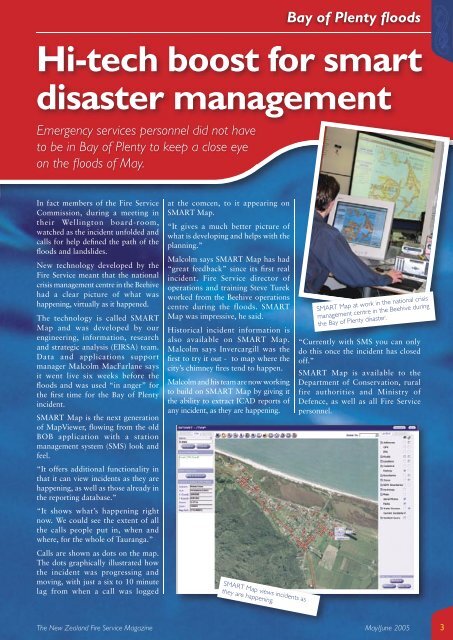
Hi-tech boost for smart<br />
disaster management<br />
Emergency services personnel did not have<br />
to be in Bay of Plenty to keep a close eye<br />
on the fl oods of May.<br />
In fact members of the <strong>Fire</strong> <strong>Service</strong><br />
Commission, during a meeting in<br />
their Wellington board-room,<br />
watched as the incident unfolded and<br />
calls for help defi ned the path of the<br />
fl oods and landslides.<br />
<strong>New</strong> technology developed by the<br />
<strong>Fire</strong> <strong>Service</strong> meant that the national<br />
crisis management centre in the Beehive<br />
had a clear picture of what was<br />
happening, virtually as it happened.<br />
The technology is called SMART<br />
Map and was developed by our<br />
engineering, information, research<br />
and strategic analysis (EIRSA) team.<br />
Data and applications support<br />
manager Malcolm MacFarlane says<br />
it went live six weeks before the<br />
fl oods and was used “in anger” for<br />
the fi rst time for the Bay of Plenty<br />
incident.<br />
SMART Map is the next generation<br />
of MapViewer, fl owing from the old<br />
BOB application with a station<br />
management system (SMS) look and<br />
feel.<br />
“It offers additional functionality in<br />
that it can view incidents as they are<br />
happening, as well as those already in<br />
the reporting database.”<br />
“It shows what’s happening right<br />
now. We could see the extent of all<br />
the calls people put in, when and<br />
where, for the whole of Tauranga.”<br />
Calls are shown as dots on the map.<br />
The dots graphically illustrated how<br />
the incident was progressing and<br />
moving, with just a six to 10 minute<br />
lag from when a call was logged<br />
at the comcen, to it appearing on<br />
SMART Map.<br />
“It gives a much better picture of<br />
what is developing and helps with the<br />
planning.”<br />
Malcolm says SMART Map has had<br />
“great feedback” since its fi rst real<br />
incident. <strong>Fire</strong> <strong>Service</strong> director of<br />
operations and training Steve Turek<br />
worked from the Beehive operations<br />
centre during the floods. SMART<br />
Map was impressive, he said.<br />
Historical incident information is<br />
also available on SMART Map.<br />
Malcolm says Invercargill was the<br />
fi rst to try it out - to map where the<br />
city’s chimney fi res tend to happen.<br />
Malcolm and his team are now working<br />
to build on SMART Map by giving it<br />
the ability to extract ICAD reports of<br />
any incident, as they are happening.<br />
SMART Map views incidents as<br />
they are happening.<br />
Bay of Plenty fl oods<br />
SMART Map at work in the national crisis<br />
management centre in the Beehive during<br />
the Bay of Plenty disaster.<br />
“Currently with SMS you can only<br />
do this once the incident has closed<br />
off.”<br />
SMART Map is available to the<br />
Department of Conservation, rural<br />
fire authorities and Ministry of<br />
Defence, as well as all <strong>Fire</strong> <strong>Service</strong><br />
personnel.<br />
The <strong>New</strong> <strong>Zealand</strong> <strong>Fire</strong> <strong>Service</strong> Magazine May/June 2005<br />
3