Detailed visual seabed survey at drilling site 7218/11-1
Detailed visual seabed survey at drilling site 7218/11-1
Detailed visual seabed survey at drilling site 7218/11-1

Create successful ePaper yourself
Turn your PDF publications into a flip-book with our unique Google optimized e-Paper software.
1.3 Aims and challenges for present <strong>survey</strong><br />
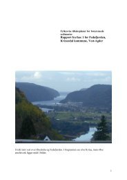
RENAScommissioneda new and more detailed <strong>visual</strong> sea bed <strong>survey</strong>in the vicinity of the SPUD<br />
loc<strong>at</strong>ion (ED50UTM34N 8.001.215,E 4<strong>11</strong>.870)for the well <strong>at</strong> Darwin (PL531). The <strong>survey</strong> was<br />
performed with parallel ROVlines 25 m apart, coveringa square of 800 times 800m within the<br />
coordin<strong>at</strong>es(ED50UTM34)E 4<strong>11</strong>.600to E 412.400,and N8.000.800 to N 8.001.600,around the<br />
plannedDarwin explor<strong>at</strong>ionwell, <strong>7218</strong>/<strong>11</strong>-1. The estim<strong>at</strong>edtotal <strong>survey</strong>distancefor the proposed<br />
programis28 km (15nm).<br />
Theprimaryaimsof the environmental<strong>survey</strong>,asgivenby RENASare:<br />
Map the presenceof spongesand other vulnerable specieson the sea bed around the<br />
planned spud loc<strong>at</strong>ion with a higher resolution than during the 20<strong>11</strong> <strong>visual</strong> <strong>survey</strong> (DNV<br />
20<strong>11</strong>).If possible,the extentof areaswith sponge aggreg<strong>at</strong>ionsis to be defined;<br />
Distinguishbetweensoft benthosandhardbenthosspeciesandcommunities;<br />
Identify asmuchaspossibleof the observedfaun<strong>at</strong>o specieslevel;<br />
Givea descriptionof the generalvulnerabilityof the area.<br />
Secondaryaims:<br />
Map areaaccordingto coverage,accordingto table in NS9435:2009,and identify speciesor<br />
subgroupsin the area;<br />
Adviseand report on suitable cuttings deposition <strong>site</strong>s for a CTSsolution basedon fauna<br />
observ<strong>at</strong>ions(spongedensities).<br />
RENASfurther specified:"The mappingshall have the highest sp<strong>at</strong>ial resolution closeto the well<br />
loc<strong>at</strong>ions(combin<strong>at</strong>ionof 20<strong>11</strong>and2012<strong>survey</strong>).Themappingshallfollow the proposedp<strong>at</strong>h, but it<br />
shall also take actual observ<strong>at</strong>ionsinto accountduring ROV<strong>survey</strong>ing.The onboard biologistsare<br />
responsiblefor the p<strong>at</strong>h optimiz<strong>at</strong>ion.<br />
The<strong>survey</strong> will be conductedwith an ROVth<strong>at</strong> asa minimum havea video camerawith sufficient<br />
lights and subseapositioningsystem.It is preferableto haveHDstill picture camerawith flashlight,<br />
HD video camera and laser for distance measurements(two laser beams with a set distance<br />
between). HD still and camerashould be connected. The <strong>survey</strong>log shall provide geo-referenced<br />
biologicalregistr<strong>at</strong>ions.".<br />
Note:in practiceit is not alwayspossibleto provideall thesespecific<strong>at</strong>ionsunderthe time restrictions<br />
whichapply, but theseshallbethe aim.<br />
<strong>Detailed</strong> <strong>site</strong> <strong>survey</strong> <strong>at</strong> PL531 Darwin<br />
Akvaplan-niva AS Rapport 6051 - 1 7