study on economic partnership projects
study on economic partnership projects
study on economic partnership projects

Create successful ePaper yourself
Turn your PDF publications into a flip-book with our unique Google optimized e-Paper software.
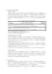
3.2.3 Natural C<strong>on</strong>diti<strong>on</strong>s Survey<br />
(1) Geodetic Survey<br />
Since geodetic survey was not carried out in this <str<strong>on</strong>g>study</str<strong>on</strong>g>, the topographic map (CAD data,<br />
1:2000) prepared by TEDI in 2005 was utilized for the review of the alignment. However, the<br />
topographic map covers <strong>on</strong>ly the alignment proposed in the BOT F/S <strong>on</strong> Trung Lu<strong>on</strong>g-My Thuan<br />
Expressway. In order to <str<strong>on</strong>g>study</str<strong>on</strong>g> the alternative alignment, the c<strong>on</strong>trol points need to be c<strong>on</strong>firmed<br />
especially the high voltage power line (locati<strong>on</strong> of towers). Moreover, affected houses and area due<br />
to the Project should be identified based <strong>on</strong> the latest site informati<strong>on</strong>. Satellite image was used as<br />
supplemental informati<strong>on</strong> for expressway planning.<br />
The following Figure 3-13 is the base map with the topographic mapping data<br />
superimposed <strong>on</strong> the satellite image.<br />
Source: Study Team<br />
Figure 3-13 Base Map for the Study<br />
3-18