
Create successful ePaper yourself
Turn your PDF publications into a flip-book with our unique Google optimized e-Paper software.
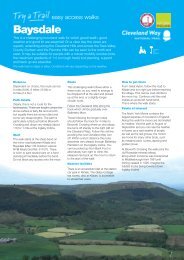
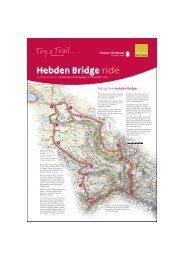
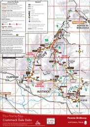
Try a Trail ...<br />
–<br />
4.3 miles (6.9 km) – moderate circular walk<br />
9<br />
10<br />
8<br />
11<br />
7<br />
Other short walks on the Yorkshire Wolds way can be found on<br />
www.nationaltrail.co.uk/yorkshirewoldsway/planning a trip<br />
6<br />
1<br />
2<br />
5<br />
4<br />
Yorkshire Wolds Way<br />
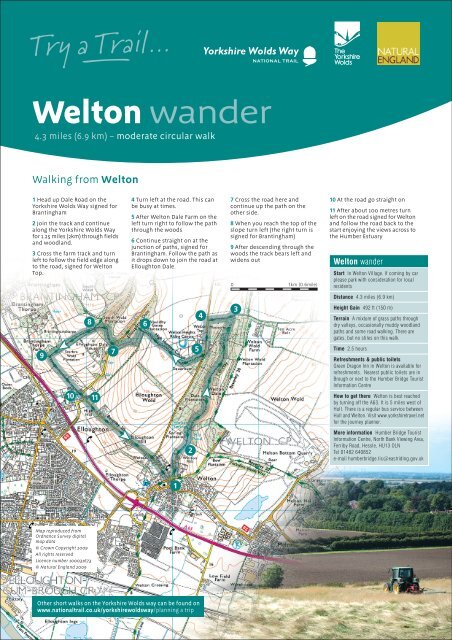
<strong>Welton</strong> <strong>wander</strong><br />
Walking from <strong>Welton</strong><br />
1 Head up Dale Road on the<br />
Yorkshire Wolds Way signed for<br />
Brantingham<br />
2 Join the track and continue<br />
along the Yorkshire Wolds Way<br />
for 1.25 miles (2km) through fields<br />
and woodland.<br />
3 Cross the farm track and turn<br />
left to follow the field edge along<br />
to the road, signed for <strong>Welton</strong><br />
Top.<br />
Map reproduced from<br />
Ordnance Survey digital<br />
map data<br />
© Crown Copyright 2009<br />
All rights reserved<br />
Licence number 100031673<br />
© Natural England 2009<br />
4 Turn left at the road. This can<br />
be busy at times.<br />
5 After <strong>Welton</strong> Dale Farm on the<br />
left turn right to follow the path<br />
through the woods<br />
6 Continue straight on at the<br />
junction of paths, signed for<br />
Brantingham. Follow the path as<br />
it drops down to join the road at<br />
Elloughton Dale.<br />
NATIONAL TRAIL<br />
7 Cross the road here and<br />
continue up the path on the<br />
other side.<br />
8 When you reach the top of the<br />
slope turn left (the right turn is<br />
signed for Brantingham)<br />
9 After descending through the<br />
woods the track bears left and<br />
widens out<br />
0 1km (0.6mile)<br />
3<br />
10 At the road go straight on<br />
11 After about 100 metres turn<br />
left on the road signed for <strong>Welton</strong><br />
and follow the road back to the<br />
start enjoying the views across to<br />
the Humber Estuary<br />
<strong>Welton</strong> <strong>wander</strong><br />
Start In <strong>Welton</strong> Village. If coming by car<br />
please park with consideration for local<br />
residents<br />
Distance 4.3 miles (6.9 km)<br />
Height Gain 492 ft (150 m)<br />
Terrain A mixture of grass paths through<br />
dry valleys, occasionally muddy woodland<br />
paths and some road walking. There are<br />
gates, but no stiles on this walk.<br />
Time 2.5 hours<br />
Refreshments & public toilets<br />
Green Dragon Inn in <strong>Welton</strong> is available for<br />
refreshments. Nearest public toilets are in<br />
Brough or next to the Humber Bridge Tourist<br />
Information Centre<br />
How to get there <strong>Welton</strong> is best reached<br />
by turning off the A63. It is 5 miles west of<br />
Hull. There is a regular bus service between<br />
Hull and <strong>Welton</strong>. Visit www.yorkshiretravel.net<br />
for the journey planner.<br />
More information Humber Bridge Tourist<br />
Information Centre, North Bank Viewing Area,<br />
Ferriby Road, Hessle, HU13 OLN<br />
Tel 01482 640852<br />
e-mail humberbridge.tic@eastriding.gov.uk
Try a Trail ...<br />
–<br />
4.3 miles (6.9 km) – moderate circular walk<br />
<strong>Welton</strong> <strong>wander</strong> route profile<br />
Yorkshire Wolds Way<br />
<strong>Welton</strong> <strong>wander</strong><br />
Here is a great introduction to the Yorkshire<br />
Wolds, with plenty of woodland, uplifting<br />
views across the Humber Estuary and a<br />
chance to walk in the footsteps of an<br />
infamous highwayman!<br />
Humber Estuary – There are<br />
some great views across the<br />
Humber Estuary on this walk.<br />
The Estuary is the largest<br />
coastal plain estuary on the<br />
east coast of Britain. Its<br />
extensive mudflats provide a<br />
vital source of food for the<br />
great numbers of wildfowl and<br />
waders that can be found here.<br />
It is also important for industry<br />
and transport – with over<br />
40,000 ship movements each<br />
year. The ports here handle 14%<br />
of Britains international trade.<br />
<strong>Welton</strong> Spring – As you walk<br />
out of <strong>Welton</strong> look out for the<br />
piped outlet of the spring<br />
amongst the houses on your<br />
right. Ancient rights exist here.<br />
If you have brought some cattle<br />
with you they have the right to<br />
drink from this spring! It is<br />
possible that this spring gave<br />
the village its name.<br />
www.nationaltrail.co.uk/yorkshirewoldsway<br />
NATIONAL TRAIL<br />
Dick Turpin – The Green Dragon Inn at <strong>Welton</strong> can proudly boast to<br />
being the location where the infamous highwayman Dick Turpin<br />
was finally arrested. Back in 1739 Turpin, living under the alias of<br />
John Palmer, got drunk and shot a gamecock. Following his arrest<br />
it was discovered that he had been stealing horses in Lincolnshire<br />
and bringing them across the Humber at low tide to sell in Yorkshire.<br />
Only later, whilst waiting for trial in York, was his handwriting<br />
identified as that of the notorious Dick Turpin.