path network - Spanglefish
path network - Spanglefish
path network - Spanglefish

Create successful ePaper yourself
Turn your PDF publications into a flip-book with our unique Google optimized e-Paper software.
OUT & ABOUT<br />
Health Walking Groups<br />
There are a variety of short and longer walks on offer by<br />
local groups. Kilsyth: Fitness Al Fresco Run by North<br />
Lanarkshire Council and based at the Garrell Vale Leisure<br />
Centre in Kilsyth. Short walks are led on Thursdays and<br />
longer walks on Tuesdays. Contact Harry Marron on 01236<br />
828160. Twechar: Walk for Health A Weekly Walk for<br />
Health Group is based at Twechar Healthy Living Centre.<br />
Tel: 01236 827154. Cumbernauld & Kilsyth: Tuesday<br />
Walks Cumbernauld & Kilsyth Ramblers have a programme<br />
of gentler ‘Tuesday Walks’. Contact The Ramblers<br />
Association Scotland - www.ramblers.org.uk/scotland.<br />
Cumbernauld & Kilsyth Group contact: Hilary Shearer,<br />
01236 780136; Strathkelvin Group, 0141 776 4161<br />
Public Transport links<br />
You can get to the Kelvin Valley by<br />
bus and rail. Bus Services, details from Traveline, Telephone;<br />
0871 200 2233 www.travelinescotland.com<br />
24 Glasgow-Kilsyth-Stirling FirstBus<br />
27 Glasgow-Kilsyth-Falkirk FirstBus<br />
27X Glasgow-Twechar FirstBus<br />
43 Kilsyth-Croy-Cumbernauld Canavan’s<br />
147 Kilsyth-Croy-Airdrie Henderson’s<br />
34Q Croy-Kilsyth Circular Jay’s<br />
Rail Services, details from Network Rail,<br />
Telephone; 08457 48 49 50<br />
Croy mainline station with services to Glasgow, Stirling,<br />
Edinburgh and beyond.<br />
ABOUT US<br />
Friends of the Kelvin Valley Park<br />
Formed in 2005 to promote a Kelvin Valley countryside<br />
park. Committee members are residents of Kilsyth,<br />
Cumbernauld and the villages and include Paul Carter,<br />
James Coleman, James Hunt, Ian Jarvis, Rob Kay and Bill<br />
Taylor. Members are active in a range of activities in the<br />
valley including canals, rambling, wildlife, local history,<br />
carnival, <strong>path</strong> <strong>network</strong> etc. The 'Friends' meet with a range of<br />
organisations to encourage appropriate countryside<br />
developments and publish the Kelvin Valley Park News.<br />
We are keen to talk to any local groups about our aims -<br />
please get in touch.<br />
Kelvin Valley Park News<br />
The 'News' is published in Spring and Autumn and covers<br />
outdoor events, activities and developments in the Kelvin<br />
Valley. One thousand copies of each issue are circulated free<br />
to Councillors, Members of Parliament, Schools, Libraries,<br />
local communities and outdoor organisations and the general<br />
public. We welcome news and good quality photographs.<br />
Adverts<br />
We will scan in your colour or black and white artwork.<br />
Charges are:<br />
Col cm on 4 column page £5<br />
Col cm on 3 column page £7<br />
Half Page £150<br />
Full page £280<br />
Front and back pages 50% extra<br />
Typesetting (if instructed) 50% extra<br />
Minimum charge £25<br />
Cheques payable to: Friends of the Kelvin Valley Park<br />
Thank you to all our contributors for news and photos, Awards<br />
for all for funding this issue, Croy Historical Society for<br />
secretarial help and the News and Chronicle for<br />
publicising our events. Many thanks to Scottish Natural<br />
Heritage for financial assistance towards the leaflet.<br />
Contact Details<br />
Editor: Paul Carter,<br />
Woodlyn, High Banton,<br />
Kilsyth, G65 0RA<br />
Tel 01236 822437. Web: www.kelvinvalleypark.info<br />
OUR HERITAGE<br />
The Kelvin Valley has a rich wildlife and historical heritage.<br />
The Path Network and suggested routes will take you to<br />
wetlands and woodlands, hills and valleys, wildlife reserves<br />
and rock exposures.<br />
You can also explore man made features like the Antonine<br />
Wall, Forth & Clyde Canal, Colzium House and enjoy the<br />
many facilities of our local communities.<br />
Wildlife<br />
The valley’s wetlands are great for winter migrants escaping<br />
the Arctic and summer breeding birds back from Africa.<br />
Dumbreck Marsh Local Nature Reserve run by North<br />
Lanarkshire Council, Dullatur Marsh Nature Reserve run by<br />
the Scottish Wildlife Trust, Twechar Marsh and Banton Loch<br />
are prime places to visit.<br />
Ancient woodlands such as Bluebell Wood by Colzium and<br />
Craigmarloch Wood overlooking the canal are rich in wild<br />
flowers. There are new community woodlands in Kilsyth,<br />
Banton, Queenzieburn and Forestry Commission woods at<br />
Twechar and Nethercroy. If you want to enjoy the wildlife<br />
and open vistas of higher ground, take the <strong>path</strong>s over Croy<br />
Hill and Bar Hill or up into the Kilsyth Hills.<br />
History<br />
Two major national features run right through the valley. The<br />
Romans used the higher ground overlooking the valley to<br />
build the Antonine Wall and the canal builders used the val-<br />
ley itself for the Forth & Clyde Canal.<br />
The canal has recently been re-opened as part of the<br />
Millennium Link and has a fine marina at Auchinstarry.<br />
World Heritage Site status is coming for the Antonine Wall.<br />
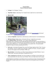
Colzium House and Estate is a public park run by North<br />
Lanarkshire Council and there are many other buildings<br />
including old mills and churches in the valley.<br />
The rich mining and quarrying history of the valley has left a<br />
legacy of old quarries and bings taken over by wildlife and<br />
old cartways and mine roads taken into the <strong>path</strong> <strong>network</strong>.<br />
Communities<br />
Local communities include the ancient Burgh of Kilsyth with<br />
shops, cafes, pubs and a swimming pool and sports centre.<br />
The villages of Banton, Banknock, Croy, Queenzieburn and<br />
Twechar have shops and pubs. The New Town of<br />
Cumbernauld has a full range of facilities and shopping.<br />
ABOUT ACCESS<br />
Safety<br />
Please note that you are responsible for your own safety and<br />
well-being and the safety and well-being of others.<br />
We cannot guarantee accuracy of all the details given in this<br />
leaflet. The map is diagrammatic and access conditions will<br />
change from time to time on the ground and may not match<br />
descriptions in this leaflet. Also please have due regard to<br />
land manager’s operations, such as farming and forestry and<br />
follow the Scottish Outdoor Access Code.<br />
Know the Code before you go<br />
Enjoy Scotland’s outdoors responsibly<br />
Everyone has the right to be on most land and inland water<br />
providing they act responsibly. Your access rights and<br />
responsibilities are explained fully in the Scottish Outdoor<br />
Access Code. Whether you’re in the outdoors or managing<br />
the outdoors, the key things are to:<br />
• Take responsibility for your own actions<br />
• Respect the interests of other people<br />
• Care for the environment<br />
To find out more or to obtain a copy of the full Code or a<br />
leaflet, visit www.outdooraccess-scotland.com<br />
www.outdooraccess-scotland.com, phone Scottish Natural<br />
Heritage on 01738 444177 or email pubs@snh.gov.uk.<br />
For local access enquiries, contact the<br />
Access Officer at<br />
North Lanarkshire Council on 01236 780636<br />
Designed and Printed by Cowan Print, Kilsyth. Tel: 01236 821177<br />
Kelvin Valley Park<br />
PATH NETWORK<br />
Kelvin Valley<br />
Path Network<br />
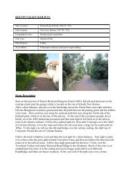
The Path Network takes you to all the major countryside<br />
attractions and communities in the Kelvin Valley. In this<br />
leaflet we give a map of the main routes and also describe<br />
some suggested routes.<br />
Many of the <strong>path</strong>s are surfaced and signposted and are<br />
suitable for all abilities and for cyclists and horse riders as<br />
well as for walkers. Others are unsigned and often<br />
unsurfaced and are less used, but can be a delight for the<br />
more adventurous. There are many other more minor <strong>path</strong>s<br />
and rights of way which we have not shown, please tell us<br />
about any that you use.<br />
The Kelvin Valley has been lived in for thousands of years<br />
and you can walk in the footsteps of the Romans along the<br />
Antonine Wall, along the tow<strong>path</strong> of the Forth & Clyde<br />
Canal, along many old mine and quarry roads, follow the<br />
routes of old railways and enjoy grand old estate avenues.<br />
Our <strong>path</strong> <strong>network</strong> also links us to the wider world. It is part<br />
of a cross Scotland route using the Millennium Link canal<br />
tow<strong>path</strong>s, connects to the West Highland Way by the<br />
Kirkintilloch to Strathblane <strong>path</strong> and is part of the Lands<br />
End to John O’Groats route. So however far you wish to<br />
travel, either 1 mile round Colzium or 1395 miles from end<br />
to end, the Kelvin Valley is truly at the centre of things.<br />
Path Network
SUGGESTED ROUTES<br />
KILSYTH<br />
1. COLZIUM LENNOX ESTATE CIRCUIT: Leave the<br />
Burngreen and go up Burnbank Terrace, cross the Stirling<br />
Road onto Tak Ma Doon Road. After 1/3 mile turn right<br />
onto a <strong>path</strong> that follows the Lade through the Estate to<br />
Banton Loch. At the second bridge go left which leads up to<br />
Colzium House. Before reaching the house go sharp left and<br />
continue on a tarmac <strong>path</strong> to North Lodge where you turn<br />
right towards the site of Colzium Castle. At a tall waymark<br />
post take the <strong>path</strong> into Colzium Glen and then cross the<br />
Glen at either the top or middle bridges. Come down the<br />
east side of the Glen and take the main drive to the Lade<br />
Burn and turn left towards Banton Loch. At the Loch turn<br />
right and walk down past a metal gate and go right to<br />
Colzium main entrance. Cross Stirling Road and return to<br />
Burngreen by the <strong>path</strong> to the rear of houses on the south<br />
side of the road. Distance: 2.75 miles.<br />
2. AUCHINSTARRY AND BACK: From Burngreen cross the<br />
Garrell Burn into Charles Street then left into East then<br />
West Burnside Street and follow the Garrell Burn to a bridge<br />
opposite St. Patrick’s School and then cross onto the south<br />
bank. At the next <strong>path</strong> junction turn left down to the River<br />
Kelvin <strong>path</strong> where you turn left to Auchinstarry. Cross the<br />
B802 and take a <strong>path</strong> at Auchinstarry Quarry to Coach<br />
Road. Return to Kilsyth by South Barrwood Road, Coach<br />
Place and Low Craigends. Distance: less than 3 miles.<br />
3. DUMBRECK NATURE RESERVE CIRCUIT: As in the<br />
previous go follow the Garrell Burn but stay on its north<br />
side until you reach the River Kelvin <strong>path</strong> which you follow<br />
downstream for 1/4 mile where you will find an entrance<br />
gate to the reserve on your right. Follow this <strong>path</strong> until just<br />
short of the next gate where a wooden bridge gives access<br />
to a boardwalk. After the boardwalk keep right and follow<br />
<strong>path</strong>s back through the Reserve to the Garrell Burn Path<br />
and return to the town centre. Distance: 3 miles.<br />
QUEENZIEBURN<br />
4. QUEENZIEBURN CIRCUIT: From a lay-by just west of<br />
Kilsyth on the Glasgow Road follow Neilston Walk to<br />
Balcastle Road. Follow this minor road as it climbs north of<br />
Queenzieburn. A shorter circuit can be made by turning<br />
down Dykehead Road. Continue past Burnhead Farm and<br />
down Whin Loan. Just south of Lossit is Joe Moses Road<br />
which you follow to Dykehead Road. During dry weather or<br />
if well shod after a short distance take the track from Old<br />
Place to the north-east of the village. If not, continue down<br />
to Queenzieburn then Meadowside Road to Arnbrae Farm<br />
Woodland. A stile gives access to a grass <strong>path</strong> which is fol-<br />
lowed towards Armbrae. Turn down the access road to<br />
Glasgow Road and the lay-by. Distance: less than 4 miles.<br />
BANTON<br />
5. THE CANAL AND BANTON LOCH: From the centre of<br />
the village follow Kelvinhead Road to Kelvinhead then a<br />
<strong>path</strong> to the west of its junction with the A803 to the Forth<br />
and Clyde Canal. Turn west along the tow<strong>path</strong> to<br />
Craigmarloch then north on the Dullatur Road to Coach<br />
Road. Turn right and follow the road to Colzium main<br />
entrance. From the lay-by turn right to Banton Loch.<br />
Continue along its south shore to Banton Road, turn left<br />
and return to the Village. Distance: 4 miles.<br />
AUCHINSTARRY<br />
6. CANAL, TWECHAR AND RIVER KELVIN CIRCUIT:<br />
Follow the Canal tow<strong>path</strong> to Twechar. Return by accessing a<br />
<strong>path</strong> a short distance along the Twechar to Queenzieburn<br />
Road. This follows the River Kelvin back to Auchinstarry.<br />
Distance: 3.25 miles.<br />
7. ANTONINE WALKWAY TO CRAIGMARLOCH & CANAL:<br />
From the Marina go along the <strong>path</strong> to the south of the Canal<br />
which shortly turns south towards Nethercroy. Just past the<br />
picnic site go left, through another gate and follow the <strong>path</strong><br />
to a junction where you turn left. In just over 1/2 a mile at<br />
a picnic site turn left to the Dullatur Road, turn left to<br />
Craigmarloch and return to Auchinstarry by the Canal<br />
tow<strong>path</strong>. Distance 3.25 miles.<br />
8. NORTH KILSYTH CIRCUIT: take the river Kelvin <strong>path</strong><br />
then turn north through Dumbreck Nature Reserve to Gavell<br />
Road then Stirling Road to the Glasgow Road lay-by past<br />
Laird’s Hill Place. Follow the first part of the Queenzieburn<br />
Circuit to Balcastle Farm and turn right to Allanfauld Farm<br />
where you turn down Allanfauld Road. Turn left at Garrell<br />
Avenue, continue on an unsurfaced private road (Neilston<br />
Walk) and across Hill Road. In 1/4 of a mile drop down<br />
onto Tak Ma Doon Road and cross into a wood, a <strong>path</strong><br />
leads down to the Lade Burn Path, turn left alongside the<br />
Lade then right to the Colzium Curling Pond and walk<br />
through the woods to the south of the pond to Colzium<br />
main entrance. Cross Stirling Road and head towards Coach<br />
Road, go right then bear left in 2/3 mile to Auchinstarry.<br />
Distance 6 miles.<br />
TWECHAR<br />
9. BAR HILL AND CANAL: From near the War Memorial<br />
follow the Historic Scotland marked track and in less than<br />
half a mile go left through a gate and then another to the<br />
Roman Fort site at Bar Hill. From Bar Hill take a <strong>path</strong> east<br />
north-east to Castle Hill viewpoint then either return to pick<br />
up the Barr Hill <strong>path</strong> east towards Croy or descend steeply<br />
north then east to follow the line of the Antonine Wall pick-<br />
ing up the Military Way 1/2 mile further east. Continue to<br />
and cross the B802 then through 2 stiles to reach Nether<br />
Croy. Return to Auchinstarry by the Antonine Walkway Trust<br />
<strong>path</strong> and then along the tow<strong>path</strong> to Twechar. Distance: 4.5<br />
miles.<br />
CROY<br />
10. ANTONINE WALL AND FORTH & CLYDE CANAL:<br />
From Nethercroy follow the Antonine Wall east over Croy<br />
hill. Keep to the north side of the line of the wall ditch until<br />
you meet a <strong>path</strong>, turn left and then in 200 yards right<br />
towards Dullatur Road, turn left to Craigmarloch and follow<br />
the canal tow<strong>path</strong> to Auchinstarry. Cross the canal by the<br />
B802 to the marina. At the east end of the marina an<br />
Antonine Walkway Trust <strong>path</strong> is followed back to<br />
Nethercroy. Distance 3.5 miles.<br />
CUMBERNAULD<br />
11. WESTERWOOD TO THE ANTONINE WALL: Follow a<br />
track north from near Old Inns interchange to Westerwood<br />
Farm buildings. Go left towards Dullatur along the line of<br />
the wall. At the Dullatur Road continue west to the canal at<br />
Craigmarloch or Croy Hill. Distance: 3.5 miles<br />
BANKNOCK<br />
12. BANKNOCK AND CANAL: Start at Bog Road in<br />
Banknock Village, take the Doups Burn <strong>path</strong> opposite Spar<br />
Grocers to Wyndford Lock on the Forth & Clyde Canal.<br />
Follow the canal tow<strong>path</strong> east for 1/2 a mile to Red Burn<br />
Aqueduct, take the <strong>path</strong> down the embankment then follow<br />
the signposted <strong>path</strong> over the River Bonny bridge and across<br />
fields to the housing estate at Weelparkland and back<br />
through the estate to the start point. Distance: 2 miles<br />
Very many different routes can be followed using the<br />
Kelvin Valley Path Network. You can use the map as<br />
a useful guide but please note this is diagramatic.<br />
Also use the O.S. Explorer map 348 for more detail.<br />
Here we give a selection of twelve routes starting from the<br />
communities in and around the valley and taking in many<br />
of the natural and historical attractions.<br />
O.S. Copyright © Crown Copyright and/or Database Right.<br />
All rights reserved. Licence Number 100046930