

NM Scenic Byway - Kirtland Force Support Home
NM Scenic Byway - Kirtland Force Support Home
NM Scenic Byway - Kirtland Force Support Home

You also want an ePaper? Increase the reach of your titles
YUMPU automatically turns print PDFs into web optimized ePapers that Google loves.
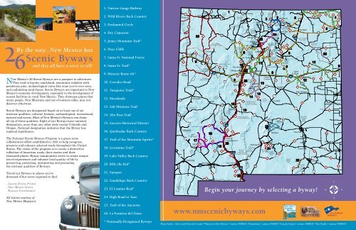
2<br />
By the way...New Mexico has<br />
<strong>Scenic</strong> <strong>Byway</strong>s<br />
and they all have a story to tell!<br />
6<br />
New Mexico’s 26 <strong>Scenic</strong> <strong>Byway</strong>s are a passport to adventure.<br />
They lead to big-sky ranchland, mountains redolent with<br />
ponderosa pine, archaeological ruins like none you’ve ever seen,<br />
and undulating sand dunes. <strong>Scenic</strong> <strong>Byway</strong>s are important to New<br />
Mexico’s economic development, especially to the development of<br />
tourist facilities in rural New Mexico. They showcase places that<br />
many people, New Mexicans and out-of-towners alike, may not<br />
discover otherwise.<br />
<strong>Scenic</strong> <strong>Byway</strong>s are designated based on at least one of six<br />
intrinsic qualities: cultural, historic, archaeological, recreational,<br />
natural and scenic. Most of New Mexico’s <strong>Byway</strong>s can claim<br />
all six of these qualities. Eight of our <strong>Byway</strong>s have national<br />
designation, more than any other state except Colorado and<br />
Oregon. National designation indicates that the <strong>Byway</strong> has<br />
regional significance.<br />
The National <strong>Scenic</strong> <strong>Byway</strong>s Program is a grass-roots<br />
collaborative effort established in 1991 to help recognize,<br />
preserve and enhance selected roads throughout the United<br />
States. The vision of the program is to create a distinctive<br />
collection of American roads, their stories and their<br />
treasured places. <strong>Byway</strong> communities strive to create unique<br />
travel experiences and enhance local quality of life by<br />
preserving, protecting, interpreting and promoting<br />
the intrinsic qualities of <strong>Byway</strong>s.<br />
Travel our <strong>Byway</strong>s to places you’ve<br />
dreamed of but never expected to find.<br />
- Laurie Evans Frantz<br />
New Mexico <strong>Scenic</strong><br />
<strong>Byway</strong>s Coordinator<br />
All stories courtesy of<br />
New Mexico Magazine<br />
1. Narrow Gauge Railway<br />
2. Wild Rivers Back Country<br />
3. Enchanted Circle<br />
4. Dry Cimarron<br />
5. Jemez Mountain Trail*<br />
6. Puye Cliffs<br />
7. Santa Fe National Forest<br />
8. Santa Fe Trail*<br />
9. Historic Route 66*<br />
10. Corrales Road<br />
11. Turquoise Trail*<br />
12. Mesalands<br />
13. Salt Missions Trail<br />
14. Abo Pass Trail<br />
15. Socorro Historical District<br />
16. Quebradas Back Country<br />
17. Trail of the Mountain Spirits*<br />
18. Geronimo Trail*<br />
19. Lake Valley Back Country<br />
20. Billy the Kid*<br />
21. Sunspot<br />
22. Guadalupe Back Country<br />
23. El Camino Real*<br />
24. High Road to Taos<br />
25. Trail of the Ancients<br />
26. La Frontera del Llano<br />
* Nationally-Designated <strong>Byway</strong>s<br />
180<br />
60<br />
70<br />
Coronado<br />
National<br />
Forest<br />
118<br />
64<br />
Shiprock<br />
Zuni<br />
Pueblo<br />
180<br />
666<br />
666<br />
Gallup<br />
17<br />
25<br />
118<br />
Apache National Forest<br />
Glenwood<br />
15<br />
371<br />
Cibola National Forest<br />
Gila National Forest<br />
Gila<br />
Wilderness Area<br />
Gila<br />
National<br />
Forest<br />
Lordsburg<br />
Quemado<br />
Silver<br />
City<br />
Farmington<br />
Crownpoint<br />
18<br />
40<br />
19<br />
23<br />
1<br />
Aztec<br />
550<br />
Carson<br />
National<br />
84 Chama<br />
Forest<br />
Heron Lake<br />
84<br />
State Park<br />
35<br />
Deming<br />
10<br />
9<br />
122<br />
Grants<br />
El Malpais<br />
National Monument<br />
59<br />
152<br />
11<br />
550<br />
Chaco Culture<br />
National Historic Park<br />
Datil<br />
Cibola<br />
National<br />
Forest<br />
27 187<br />
Cibola National Forest<br />
124<br />
1<br />
60<br />
380<br />
Cibola<br />
National<br />
Forest<br />
Cibola<br />
National<br />
Forest<br />
25<br />
181<br />
Rio Chama<br />
State Recreation Area<br />
Cuba<br />
9<br />
15<br />
185<br />
51<br />
25<br />
28<br />
550<br />
364<br />
1<br />
478<br />
20<br />
126<br />
Fenton Lake<br />
State Park<br />
23<br />
Tierra<br />
Amarilla<br />
10<br />
Rio Rancho<br />
Albuquerque<br />
Socorro<br />
Las Cruces<br />
314<br />
Belen<br />
Truth or<br />
Consequences<br />
313<br />
10<br />
47<br />
60<br />
408<br />
4<br />
23<br />
47<br />
16<br />
84<br />
Abiquiu<br />
70<br />
Carson<br />
National<br />
Forest<br />
Española<br />
14<br />
601<br />
Los Alamos<br />
Bandelier<br />
National<br />
Monument<br />
San Ysidro<br />
Cibola<br />
National<br />
Forest<br />
Cibola<br />
National<br />
Forest<br />
Bosque del Apache<br />
National Wildlife Refuge<br />
Manzano<br />
Mountain 337<br />
State Park<br />
Photo Credits - Above Left (From left to right: “Welcome to New Mexico,” courtesy <strong>NM</strong>DOT; “Golandrinas,” courtesy <strong>NM</strong>DOT; “Lincoln County,” courtesy <strong>NM</strong>DOT, “Taos Pueblo,” courtesy <strong>NM</strong>DOT)<br />
54<br />
84<br />
Sevilletta National<br />
Wildlife Refuge<br />
(Closed to the Public)<br />
White<br />
Sands<br />
San Andres National<br />
National Monument<br />
Wildlife Refuge<br />
(Closed to the Public)<br />
380<br />
6<br />
23<br />
11<br />
13<br />
285<br />
Tres<br />
Piedras<br />
Santa Fe<br />
14<br />
55<br />
41<br />
Alamogordo<br />
13<br />
82<br />
7<br />
2<br />
Cibola<br />
National<br />
Forest<br />
20<br />
6563<br />
Carson<br />
National<br />
Forest<br />
21<br />
506<br />
522<br />
Morphy Lake<br />
State Park<br />
130<br />
24<br />
Carson<br />
National<br />
Forest<br />
475<br />
Hyde Memorial<br />
State Park<br />
50<br />
60<br />
Oliver Lee<br />
State Park<br />
Taos<br />
Santa Fe<br />
National<br />
Forest<br />
3<br />
63<br />
Santa Fe National Forest<br />
Clines<br />
Corners<br />
Carrizozo<br />
Lincoln<br />
National<br />
Forest<br />
Questa<br />
54<br />
Lincoln<br />
National<br />
Forest<br />
Ruidoso<br />
24<br />
Red River<br />
518<br />
38<br />
Eagle Nest<br />
64<br />
Colin Noblett<br />
Wildlife Area<br />
Angel Fire<br />
161<br />
82<br />
161<br />
9<br />
21<br />
8<br />
Las Vegas<br />
National<br />
Wildlife<br />
Refuge<br />
84<br />
246<br />
Las Vegas<br />
3 219<br />
Corona<br />
Vaughn<br />
Lincoln<br />
National<br />
Forest<br />
137<br />
8<br />
25<br />
Santa<br />
Rosa<br />
13<br />
285<br />
Raton<br />
22<br />
64<br />
Springer<br />
Kiowa National<br />
Grasslands<br />
20<br />
12<br />
Fort Sumner<br />
Roswell<br />
Artesia<br />
Bitter Lake<br />
National<br />
Wildlife<br />
Refuge<br />
Carlsbad<br />
Caverns<br />
National<br />
Park<br />
62<br />
72<br />
325<br />
12<br />
62<br />
360<br />
285<br />
551<br />
Chicosa Lake<br />
State Park<br />
56<br />
325<br />
Mosquero<br />
Tucumcari<br />
Carlsbad<br />
Begin your journey by selecting a byway!<br />
www.nmscenicbyways.com<br />
285<br />
40<br />
91<br />
60<br />
156<br />
84<br />
129<br />
156 209<br />
453<br />
456<br />
8<br />
420<br />
26<br />
529<br />
457<br />
128<br />
278<br />
114<br />
176<br />
370<br />
Clayton<br />
Lovington<br />
54<br />
4<br />
406<br />
Kiowa National<br />
Grasslands<br />
469<br />
406<br />
410<br />
Clovis<br />
Portales<br />
Hobbs<br />
18
1N.M. <strong>Scenic</strong> <strong>Byway</strong><br />
Narrow Gauge<br />
Railway<br />
By Laurie Evans Frantz<br />
The J-9 Narrow Gauge <strong>Scenic</strong> <strong>Byway</strong> has had many twists<br />
and turns, both literally and historically. This isolated road<br />
winds through a beautiful and dramatic landscape. It started as<br />
a primitive trail forged by early settlers and miners, and became<br />
a crude toll road in 1877. In the early 1800s, the Denver and Rio<br />
Grande Western Railroad laid track on the same alignment. It<br />
has come full circle–the track has been removed and it is once<br />
again a largely unimproved road, now known as Jicarilla 9.<br />
The D&RG Railway Company, incorporated in 1870, planned<br />
to lay track from Denver to El Paso, Texas and ultimately to<br />
Mexico City. Six branches would serve the booming silver mining<br />
areas of Colorado. Both the rough terrain and the cheaper cost<br />
of construction and operations led to the company’s decision to<br />
use narrow gauge track, with rails laid three feet apart rather<br />
than the standard 4 feet 8.5 inches. Minimal grading was done<br />
in preparation for laying the track, and the line ran through<br />
narrow canyons and over steep grades.<br />
In late 1881, the San Juan Branch was completed from<br />
Antonito to Durango, Colorado and from there to Farmington<br />
and Chama connecting the east and west sides of the Rocky<br />
Mountains. It served isolated farming and mining areas,<br />
transporting raw materials like timber and mineral ore,<br />
passengers and tourists. After the silver boom ended in 1893, the<br />
freight shifted to agricultural products and timber milled by a<br />
Pagosa Springs, Colorado lumber company. By 1915 the timber<br />
supply had nearly disappeared, and the company moved its<br />
operations to Dulce, a station on the San Juan Branch, where it<br />
built a new mill and company town in 1916.<br />
In 1935 the San Juan Branch stopped operation for freight<br />
shipment completely, in 1951 it discontinued daily passenger<br />
service, and in 1968 it was abandoned between Chama and<br />
Durango. The Cumbres-Toltec (in Chama, 800-CUMBRES)<br />
and Durango-Silverton (888-872-4607 in Durango) lines, which<br />
continue in operation today as tourist lines, are all that remain of<br />
the San Juan Branch. It doesn’t take a railroad buff to enjoy the<br />
sound of a steam engine and the rhythmic clack of wheels on the<br />
narrow gauge, and the mountain scenery is enchanting.<br />
1. Narrow Gauge Railway >>><br />
2. Wild Rivers Back Country<br />
3. Enchanted Circle<br />
4. Dry Cimarron<br />
5. Jemez Mountain Trail*<br />
6. Puye Cliffs<br />
7. Santa Fe National Forest<br />
8. Santa Fe Trail*<br />
9. Historic Route 66*<br />
10. Corrales Road<br />
11. Turquoise Trail*<br />
12. Mesalands<br />
13. Salt Missions Trail<br />
14. Abo Pass Trail<br />
15. Socorro Historical District<br />
16. Quebradas Back Country<br />
17. Trail of the Mountain Spirits*<br />
18. Geronimo Trail*<br />
19. Lake Valley Back Country<br />
20. Billy the Kid*<br />
21. Sunspot<br />
22. Guadalupe Back Country<br />
23. El Camino Real*<br />
24. High Road to Taos<br />
25. Trail of the Ancients<br />
26. La Frontera del Llano<br />
* Nationally-Designated <strong>Byway</strong>s<br />
Narrow<br />
Gauge Railway<br />
The greatest significance of this corridor today is the fact that<br />
it connects the sovereign nations of the Jicarilla Apache in<br />
New Mexico and the Southern Ute in Colorado. J-9 facilitates<br />
the exchange of commodities and religious and cultural heritage<br />
between the two tribes.<br />
The Utes are the oldest continuous residents of Colorado. Two<br />
of the seven original Ute bands, the Mouache and Capote, make<br />
up the present day Southern Ute Indian Tribe. They reside on<br />
approximately 800,000 acres in southern Colorado. The Jicarilla<br />
Tribe consists of two bands: the Llaneros, or plains people, and<br />
the Olleros, or mountain valley people. They once roamed a large<br />
part of northeastern New Mexico and southern Colorado. In<br />
1887, they were given a permanent reservation in north central<br />
New Mexico, which now encompasses one million acres.<br />
J-9 now parallels or overlays about ten miles of the old railroad<br />
bed from Dulce northeast to the Colorado border. Most of the<br />
original track has been removed, but a short segment remains<br />
at the junction of US 64 and J-9 (called Narrow Gauge Street<br />
here) in Dulce. Two old D&RGW wooden boxcars sit next to the<br />
Jicarilla Culture Center (575-759-1343). Several yellow frame<br />
buildings with rust trim along the road in town were obviously<br />
associated with the D&RGW, but they have second careers as<br />
tribal administration buildings.<br />
The canyon closes in on the paved road as it continues northwest<br />
alongside Amargo Creek. After about four miles, the pavement<br />
and the creek disappear. The station stop of Navajo was here<br />
at the confluence of Amargo Creek and the Navajo River. Still<br />
Photo Credits - Above Left (From left to right: “Vintage Train Photographs” Shutterstock® Images)<br />
Above Right (“D&RGWRR Bridge and original water tank” courtesy <strong>NM</strong>DOT)<br />
D&RGWRR Bridge<br />
and original water tank<br />
present to testify to the presence of busier times are a round<br />
yellow water tank with rust red roof and timber supports and a<br />
steel truss bridge across the river. A plaque on the bridge says<br />
that this was once the D&RGWRR Royal Gorge Route <strong>Scenic</strong><br />
Line. Where tracks once were, planks were laid to allow cars over<br />
the bridge. It outlived even that use and has now been bypassed<br />
completely by a modern concrete bridge to the west. Fortunately,<br />
it has been allowed to remain, an elegant witness of earlier times.<br />
Continuing north, the road narrows, and rock outcrops and tall<br />
pines loom down from either side. Horses graze by the river,<br />
which at this time of year is iced over completely in some places.<br />
Where you can see it, black water races to Colorado. This is not<br />
a road to drive in wet or very cold weather. Where it isn’t snowpacked,<br />
it is deeply rutted by previous travelers who may or may<br />
not have had the luck (like I did) to have been rescued by one of<br />
the eight Game and Fish Officers who patrol the reservation’s one<br />
million acres.<br />
Riding in a train through these narrow, winding canyons must<br />
have been an adventure in the late 1800s. Traveling this road is<br />
still an adventure, even in the comfort of an automobile.
2N.M. <strong>Scenic</strong> <strong>Byway</strong><br />
Wild Rivers<br />
Back Country<br />
By Marti Niman<br />
The sagebrush and pinon-juniper flatlands of the Taos Plateau<br />
are sliced by a steep chasm of black rock carved 600-800<br />
vertical feet to a ribbon of river, circled by volcanic cones, cliffs<br />
and the Sangre de Cristo’s white-dusted peaks. Deceptively<br />
tame, the Wild Rivers Back Country <strong>Byway</strong> provides ready<br />
access to the rock-strewn, riffling upper reaches of the Rio<br />
Grande before dams and diversions dampen the river’s unruly<br />
ways–a haven for hikers, cyclists, wildlife-viewers, sportfishermen<br />
and sightseers. The spectacular 360-degree vista at<br />
La Junta Overlook, where the Red River joins the Rio Grande<br />
800 feet below, is singularly worth the drive.<br />
The byway loops through the Wild Rivers Recreation Area,<br />
managed by the Bureau of Land Management Taos Field<br />
Office (575-758-8851) and is open year round, although it may<br />
be snow-packed in winter. Beginning about two miles north<br />
of Questa on N.M. 378, the road winds between Our Lady<br />
of Guadalupe Church and the flag-studded cemetery in the<br />
agricultural village of Cerro. As the byway enters the pungent<br />
sage flats, Cerro Chiflo is visible jutting out of the gorge at<br />
Bear Crossing. On clear days, the frothy peaks surrounding<br />
Mt. Blanca in Colorado peek over the horizon’s edge. Dirt<br />
parking areas dot the road at trailheads bearing such<br />
colorful names as Chawalauna, El Aguaje and Big and<br />
Little Arsenic Springs.<br />
Rumor has it that Big Arsenic Springs were so-named because<br />
a hermit living at the bottom of the gorge told folks there was<br />
arsenic in the water so he could keep it to himself. Today, Big<br />
Arsenic Springs offers a self-guided nature trail, a developed<br />
campground and trail access to the river, where visitors may<br />
hear the cascading song of a canyon wren or the whistle of a<br />
hawk overhead. Several trails reach the river and back country<br />
campsites at the bottom of the gorge. Porous volcanic rocks<br />
tumble down the cliffs into the water, useful as stepping-stones<br />
or basking boulders for those in a lizard state of mind.<br />
Guadalupe Mountain, Red River Fault and Rinconada hiking<br />
and biking trails explore the unique geology and plant life of<br />
the Taos Plateau, ranging from the level stroll of Rinconada<br />
1. Narrow Gauge Railway<br />
2. Wild Rivers Back Country >>><br />
3. Enchanted Circle<br />
4. Dry Cimarron<br />
5. Jemez Mountain Trail*<br />
6. Puye Cliffs<br />
7. Santa Fe National Forest<br />
8. Santa Fe Trail*<br />
9. Historic Route 66*<br />
10. Corrales Road<br />
13. Salt Missions Trail<br />
14. Abo Pass Trail<br />
15. Socorro Historical District<br />
16. Quebradas Back Country<br />
17. Trail of the Mountain Spirits*<br />
18. Geronimo Trail*<br />
19. Lake Valley Back Country<br />
20. Billy the Kid*<br />
21. Sunspot<br />
22. Guadalupe Back Country<br />
23. El Camino Real*<br />
24. High Road to Taos<br />
25. Trail of the Ancients<br />
26. La Frontera del Llano<br />
* Nationally-Designated <strong>Byway</strong>s<br />
WILD RIVERS<br />
BACK COUNTRY<br />
11. Turquoise Trail The spectacular scenery of<br />
Wild Rivers Back Country <strong>Byway</strong><br />
12. Mesalands<br />
Loop’s wide gravel path along the rim to the 1,000-foot uphill<br />
grunt at Guadalupe Mountain, which rewards the energetic with<br />
expansive views, tall pines, wildflowers and cool air. La Junta<br />
Trail descends sharply in a series of switchbacks, stairs and a<br />
ladder to the Red River-Rio Grande confluence, where ponderosa<br />
pines offer tall shade for trout anglers.<br />
The Taos Plateau is the largest volcanic field within<br />
the Rio Grande Rift, its layers of thick basalt deeply sliced<br />
north-south by the river. Rifts are cracks in the earth’s crust<br />
along faults that pull apart, tilting downward to form a valley<br />
and mountains. Here, the Sangre de Cristo Range edges the<br />
horizon to the east and the Tusas Mountains to the west, while<br />
numerous dormant volcanic cones pop impertinently out of the<br />
broad tortilla flatlands of sage. Ute Mountain looms to the north<br />
and the domes of Pot Mountain and San Antonio to the west<br />
and northwest–all three providing habitat to elk, mule deer and<br />
pronghorn as well as coyote, badger and other wildlife.<br />
Red-tailed hawks circle the cliffs and mesas, their tails flashing<br />
copper in the sunlight, while mountain bluebirds dart across the<br />
mesa like tiny pieces of the southwestern sky torn off and set<br />
aflight. Mule deer drift soundlessly at dusk and tracks of cougar<br />
and bear may be traced in the sand.<br />
The upper reaches of the Rio Grande are a whitewater<br />
wonderland for kayakers and rafters in years of abundant<br />
Photo Credits - Above Left (From left to right: Shutterstock® Images)<br />
Above Right (From left to right: “Wild Rivers” courtesy <strong>NM</strong>DOT)<br />
snowfall. The river enters New Mexico like a lamb and then, at<br />
the Class 4 Razorblade Rapids near Ute Mountain, it begins to<br />
roar. Dropping 200 feet per mile into the Upper Taos Box,<br />
it is too dangerous for rafting until it reaches the mellower<br />
flows at the Rio Grande-Red River confluence. Boating within<br />
the Wild Rivers Recreation Area is hazardous and requires a<br />
permit, while swimming is dangerous due to swift currents and<br />
icy temperatures.<br />
Anglers find the challenge of rainbow trout, northern pike<br />
and brown trout enhanced by deep pools and a rush of rapids<br />
that echo from black cliffs framing a sliver of sky. Those feisty<br />
browns grow up from small fry that “trek” the steep icy trails<br />
each winter, packed in 5-gallon water jugs on the backs of<br />
Game and Fish officers and volunteers from the Bureau of<br />
Land Management, the Carson National Forest and local<br />
sportsmen’s groups. The annual Rio Grande Brown Trout Trek is<br />
a midwinter work party shared by local fishing enthusiasts and<br />
biologists. Nearby Red River State Fish Hatchery (575-586-0222)<br />
raises trout for stocking the gorge and other waters in the area.<br />
Fishing licenses and a habitat stamp are required and may be<br />
purchased in Questa.<br />
The byway loops past the Wild Rivers Visitor Center<br />
(575-586-2405), open daily from Memorial Day to Labor Day,<br />
which contains a mural painted by a collaboration of New<br />
Mexico artists who share a passion for the area and its wildlife.<br />
Most visitors to the area find its rugged yet accessible wildness
3N.M. <strong>Scenic</strong> <strong>Byway</strong><br />
The Enchanted<br />
Circle<br />
By Laurie Evans Frantz<br />
The Enchanted Circle <strong>Scenic</strong> <strong>Byway</strong> has a taste of everything<br />
that’s New Mexico. It links the oldest continuously occupied<br />
residence in New Mexico, Taos Pueblo, with Angel Fire, which<br />
was incorporated in 1986. It is home to the United States’ first<br />
memorial to Vietnam War veterans. It passes by Elizabethtown,<br />
New Mexico’s first incorporated town, now a ghost town. Much<br />
of the <strong>Byway</strong> traverses land formerly part of the Maxwell Land<br />
Grant, once the largest private, individual holding in the western<br />
hemisphere. The movie industry discovered this area long ago,<br />
producing such films as “Butch Cassidy and the Sundance Kid”<br />
and “Easy Rider.”<br />
The byway begins in Taos on <strong>NM</strong> 522. The first to call the Taos<br />
Valley home were Tiwa-speaking Pueblo Indians, who settled<br />
there about 1,000 years ago and built two communal dwellings on<br />
either side of the Rio Pueblo. Taos Pueblo’s beautiful multi-story<br />
skyline was already there when Hernan de Alvarado arrived in<br />
1540. The upper stories are only reached by ladders, since there<br />
are no interior stairways. Modern utilities are prohibited in this<br />
part of the pueblo.<br />
Taos was established about 1615 as an outpost of New Spain.<br />
It was an early gathering place for mountain men, including<br />
Kit Carson and Ceran St. Vrain. Taos has been an artists’ haven<br />
ever since the Taos Society of Artists was formed in 1914. Later,<br />
art patron Mabel Dodge Lujan brought noted artists and authors<br />
like D.H. Lawrence, Georgia O’Keeffe, Nicolai Fechin, and Ansel<br />
Adams. The town is a treasure trove of old homes, museums,<br />
interesting shops, and art galleries.<br />
The Rio Grande Gorge bridge, twelve miles northwest of Taos<br />
on US 64, is a must-see side trip. When it was built in the<br />
mid-1960s, it was called the “bridge to nowhere”, because funding<br />
didn’t exist to continue the road on the other side. It is the<br />
second highest suspension bridge in the United States.<br />
Returning to the Circle, Arroyo Hondo is nine miles north of<br />
Taos on <strong>NM</strong> 522. It grew out of an 1815 Spanish land grant<br />
on the Rio Hondo. In the 1960s it was the home of the New<br />
Buffalo commune.<br />
1. Narrow Gauge Railway<br />
2. Wild Rivers Back Country<br />
3. Enchanted Circle >>><br />
4. Dry Cimarron<br />
5. Jemez Mountain Trail*<br />
6. Puye Cliffs<br />
7. Santa Fe National Forest<br />
8. Santa Fe Trail*<br />
9. Historic Route 66*<br />
10. Corrales Road<br />
11. Turquoise Trail*<br />
12. Mesalands<br />
13. Salt Missions Trail<br />
14. Abo Pass Trail<br />
15. Socorro Historical District<br />
16. Quebradas Back Country<br />
17. Trail of the Mountain Spirits*<br />
18. Geronimo Trail*<br />
19. Lake Valley Back Country<br />
20. Billy the Kid*<br />
21. Sunspot<br />
22. Guadalupe Back Country<br />
23. El Camino Real*<br />
24. High Road to Taos<br />
25. Trail of the Ancients<br />
26. La Frontera del Llano<br />
* Nationally-Designated <strong>Byway</strong>s<br />
ENCHANTED<br />
CIRCLE<br />
The Enchanted<br />
Circle <strong>Scenic</strong><br />
<strong>Byway</strong><br />
The hippies from the commune have since dispersed into the<br />
general population of northern New Mexico, adding their own<br />
flavoring to the local culture.<br />
The entrance to the D.H. Lawrence Ranch is on the way to<br />
Questa. Lawrence only spent a total of eleven months in<br />
New Mexico, but it influenced him profoundly. He wrote<br />
parts of several works here, and his ashes are housed in the<br />
memorial chapel. The Ranch is now owned by the University<br />
of New Mexico, which uses it for educational, cultural and<br />
recreational purposes.<br />
The next stop is Questa. Settled before the 1840s, it is<br />
situated in the middle of wonderful hiking and camping<br />
places, including Cabresto Lake, Mallette Canyon, and<br />
Midnight Meadows.<br />
East on <strong>NM</strong> 38 from Questa and traveling toward Red River,<br />
the road is a roller coaster ride. Red River was settled by<br />
miners from Elizabethtown in the late 1800s. The mines<br />
petered out, and the town is now known for its beautiful, high<br />
alpine scenery, skiing, fishing and switchback roads through<br />
old mining country.<br />
The road runs through Bobcat Pass, at 9,820 feet, and<br />
descends into the high alpine Moreno Valley. The Valley<br />
is bounded by some of the most spectacular peaks in New<br />
Mexico: Agua Fria at the south end, Baldy on the north and<br />
Wheeler on the northwest. Wheeler Peak, at 13,162 feet, is<br />
the highest point in New Mexico.<br />
Captain William Moore and friends successfully panned for<br />
gold in the Moreno Valley in the mid-1800s. Word leaked out,<br />
and Elizabethtown was born as a tent city in the 1860s. By<br />
1871, mining operations had virtually shut down, and a fire in<br />
1903 left the town to the ghosts. The shell of the stone Mutz<br />
Hotel guards the meager remains of E-town.<br />
<strong>NM</strong> 38 ends at Eagle Nest, nestled in the Moreno Valley.<br />
The village is adorned with a tiny jewel of a lake. Eagle Nest<br />
Lake, owned by the state, is stocked with kokanee salmon,<br />
and rainbow and cutthroat trout. The nomadic Moache Utes<br />
called the glow caused by the sunset on Agua Fria Peak the<br />
“fire of the spirits.” Franciscan friars later changed this to<br />
“fire of angels.” Angel Fire was named after the old legend.<br />
The <strong>Byway</strong> continues to Angel Fire on US Highway 64.<br />
The Vietnam Veterans Peace and Brotherhood Chapel is<br />
a soaring white structure pointing to the sky from a hill<br />
just west of Angel Fire. Inside the simple monument are<br />
photographs of Vietnam casualties and a shrine of mementos<br />
and candles left by visitors.<br />
The circle closes in Taos, entering town on tree-lined Kit<br />
Carson Road. What more could a traveler ask than a road<br />
that ends at its beginning and offers such wonders in a day’s<br />
drive?<br />
Photo Credits - Above Left (From left to right: “Rio Grande Gorge” Shutterstock® Images, “Rio Grande River” Shutterstock® Images, “Clouds” Shutterstock® Images)<br />
Above Right (From left to right: “Eagle Nest Lake” courtesy <strong>NM</strong>DOT, “Taos Pueblo” Shutterstock® Images)<br />
Eagle Nest Lake<br />
Pueblo of Taos
4N.M. <strong>Scenic</strong> <strong>Byway</strong><br />
Dry Cimmaron<br />
By Laurie Evans Frantz<br />
The traveler who loves big skies, lonely roads and infinite<br />
spaces will find all this and more on the Dry Cimarron <strong>Scenic</strong><br />
<strong>Byway</strong>. Early travelers on the Cimarron Cutoff of the Santa Fe<br />
Trail must have felt a sense of awe at these limitless prairies.<br />
The byway spreads across northeastern New Mexico like a web,<br />
starting east of Raton on <strong>NM</strong> 72 and crossing into Colorado<br />
and Oklahoma. At 215 miles in New Mexico alone, this is one of<br />
the longer scenic byways in the state and takes several days to<br />
explore completely.<br />
Three and a half miles east of Raton, <strong>NM</strong> 526 travels north from<br />
<strong>NM</strong> 72 through Sugarite Canyon State Park (Visitors’ Center,<br />
575-445-5607). Old buildings and foundations near the entrance<br />
to the park are the remains of Sugarite Coal Camp, in operation<br />
between 1910 and 1941. Camping, fishing, and boating are<br />
available at two small lakes, Lake Alice and Lake Maloya. The<br />
best time to make this drive is in the fall, when the leaves of the<br />
Gambel’s oak are turning every color of the fall spectrum–green<br />
to yellow to orange to flame. The leaves shivering in the wind<br />
make the hillsides vibrate with warm color.<br />
Driving east on <strong>NM</strong> 72 across Johnson Mesa, some of the most<br />
beautiful views in New Mexico unfold before you. To the north of<br />
the mesa loom the Colorado Rockies. The shadows cast by clouds<br />
drifting across the limitless sky darken the grasslands. Standing<br />
lonely on the prairie, St. John’s Methodist Episcopal Church<br />
served early ranchers in this part of Colfax County. It was built<br />
between 1896 and 1897 and is listed on the State Register of<br />
Cultural Properties.<br />
<strong>NM</strong> 72 ends in Folsom, where the traveler has the choice of<br />
driving southeast on <strong>NM</strong> 325 to Des Moines or southwest to<br />
Capulin. These towns would make perfect sets for movies<br />
depicting the early 1900s. Buildings with false fronts line their<br />
main streets. Folsom had its genesis as Ragtown, a railroad<br />
construction camp. The Folsom Hotel, on the National Register<br />
of Historic Places, dates to 1888, when the camp was renamed<br />
Folsom. The Folsom Museum (575-278-2122), formerly the<br />
Doherty Mercantile Company, looks like an antique store but the<br />
1. Narrow Gauge Railway<br />
2. Wild Rivers Back Country<br />
3. Enchanted Circle<br />
4. Dry Cimarron >>><br />
5. Jemez Mountain Trail*<br />
6. Puye Cliffs<br />
7. Santa Fe National Forest<br />
8. Santa Fe Trail*<br />
9. Historic Route 66*<br />
10. Corrales Road<br />
11. Turquoise Trail*<br />
12. Mesalands<br />
13. Salt Missions Trail<br />
14. Abo Pass Trail<br />
15. Socorro Historical District<br />
16. Quebradas Back Country<br />
17. Trail of the Mountain Spirits*<br />
18. Geronimo Trail*<br />
19. Lake Valley Back Country<br />
20. Billy the Kid*<br />
21. Sunspot<br />
22. Guadalupe Back Country<br />
23. El Camino Real*<br />
24. High Road to Taos<br />
25. Trail of the Ancients<br />
26. La Frontera del Llano<br />
* Nationally-Designated <strong>Byway</strong>s<br />
contents are not for sale. One exhibit features<br />
the Folsom Archaeological Site, one of the most<br />
famous sites in the country. Here, the first<br />
accepted evidence of Ice Age man in North<br />
America was discovered in 1926. Prehistoric<br />
spear points, dating to about 8,800 B.C., were<br />
found in the ribs of a now-extinct species of<br />
bison. The Folsom site is on private land near<br />
the town and is not open to the public.<br />
The tranquility of these three towns belies<br />
the violent upheavals that sculpted the<br />
countryside. Capulin Volcano National<br />
Monument (575-278-2201; $5.00 per vehicle),<br />
located between Folsom and Capulin, was<br />
active as recently as 10,000 years ago. A twomile<br />
drive takes you the thousand feet to the<br />
top of the cinder cone, and you can either hike<br />
around the rim or into the crater. From the<br />
top, there is an awesome view of about 100<br />
volcanoes and four states - Texas, Oklahoma, New Mexico and<br />
Colorado. Looking to the southeast, you can see Sierra Grande,<br />
the largest single mountain in the United States. Forty miles<br />
around the base and 8,720 feet high, it covers 50 square miles. To<br />
the north and west, the peaks of the Sangre de Cristo Mountains<br />
are etched against the sky on the farthest horizon.<br />
Driving through the open country between Folsom and Des<br />
Moines gives a ground view of the volcanic activity. Small<br />
hummocks covered with lava pepper the landscape. Mining<br />
of Twin Mountain, a volcano on the south side of <strong>NM</strong> 325, has<br />
revealed its flame-red core.<br />
North of Folsom, <strong>NM</strong> 456 intersects the namesake of this byway,<br />
the Dry Cimarron River, and runs parallel to it all the way to the<br />
Oklahoma border. The river isn’t completely dry but it sometimes<br />
disappears entirely under the surface, where its presence is<br />
betrayed by the many cottonwood trees nourished by its waters.<br />
Three and a half miles north of Folsom, the river flows over<br />
volcanic rocks into a small but beautiful pool at Folsom Falls<br />
Fishing Area. Administered by New Mexico Game and Fish, it is<br />
open to the public for swimming and fishing.<br />
The byway continues east on <strong>NM</strong> 456, and then north on <strong>NM</strong> 551<br />
through Tollgate Canyon to Branson, Colorado. The canyon was<br />
named for a toll road constructed here between 1871 and 1873 by<br />
Bazil Metcalf. It was one of the most reliable roads for wagons<br />
between this part of New Mexico and Colorado until the railroad<br />
came to this area in the 1880s.<br />
Back on <strong>NM</strong> 456, you can drive for miles without seeing<br />
another person, but you may see antelope, deer, hawks and wild<br />
turkeys. Much of this country is unfenced grazing land, and cattle<br />
have the right of way. They see no reason to move when a car<br />
comes along and stare placidly at the intruding offender. Two<br />
fantastic geological formations, Battleship Rock and Wedding<br />
Cake, loom above the valley floor between mile markers 45 and<br />
47. In the early days, many couples were married on top of the<br />
Wedding Cake.<br />
DRY CIMARRON<br />
South on <strong>NM</strong> 406, the road intersects McNees Crossing between<br />
mile markers 18 and 19. The three-sided Santa Fe Trail Crossing<br />
sign marks where the trail forded the North Canadian River.<br />
Indians killed Missouri traders Robert McNees and Daniel<br />
Munro here in 1828. Original Trail ruts can still be seen near<br />
the crossing. The byway follows Campbell Road to the west, just<br />
north of Seneca, where it crosses the Santa Fe Trail again. The<br />
National Park Service has a rest area here and interpretive signs,<br />
bringing attention to a two-mile stretch of the trail, marked by<br />
limestone posts. Some of the best-preserved segments of the trail<br />
are located in this area.<br />
Campbell Road intersects <strong>NM</strong> 370 on its west end. Driving south<br />
on <strong>NM</strong> 370 leads to Clayton Lake State Park (505-374-8808; $4.00<br />
per vehicle), which has one of the best dinosaur track sites in the<br />
world. More than 500 fossilized footprints were revealed when<br />
layers of earth and rock were removed for construction of the<br />
spillway. The tracks were left by at least eight kinds of dinosaurs<br />
over 100 million years ago. Huge flocks of Canada geese circle the<br />
lake and land en masse, raucously calling to one another as they<br />
move across the surface of the water.<br />
Traveling north again on <strong>NM</strong> 370 towards <strong>NM</strong> 456 are dinosaurs<br />
of a different kind. A line of old telephone poles runs alongside<br />
the road. Ten feet tall instead of the thirty-foot modern poles, you<br />
can still see the shape of the tree in these antiques. The glass<br />
insulators are gone from their wooden pegs, probably removed<br />
long ago to grace someone’s front porch. Their wires hang<br />
dejectedly down by their sides, proclaiming their uselessness.<br />
They stand sentinel over the rough-hewn stone shells of<br />
abandoned homesteads. This is a byway through lonely places<br />
and wide-open spaces. The sense of history is vast here. Traces of<br />
those who came before reveal themselves to those who seek them.<br />
Photo Credits - Above Left (From left to right: “Dry Cimmaron” courtesy <strong>NM</strong>DOT, “Grasslands” Shutterstock® Images, “Cracked Desert” Shutterstock® Images)
5 8.<br />
N.M. <strong>Scenic</strong> <strong>Byway</strong><br />
Jemez Mountain<br />
Trail<br />
By Marti Niman<br />
The Jemez Mountain Trail twists through time and terrain,<br />
contrasting vermilion desert cliffs and snowy alpine peaks,<br />
13th century stone dwellings and the birth of the Atomic Age<br />
in nearly the same breath. Travelers may fish canyon waters at<br />
dawn, don snowshoes for a woodland trek, explore ancient Pueblo<br />
ruins and view elk crossing an immense volcanic caldera–all in<br />
the same day.<br />
The trail begins at the junction of U.S. 550 and N.M. 4 in the<br />
pastoral village of San Ysidro, named for the patron saint of<br />
farmers. Passing a restored church of the same name, N.M.<br />
4 slowly winds past Jemez Pueblo, home to more than 3,000<br />
tribal members who call the village “Walatowa” in their<br />
native language, Towa. Jemez Pueblo sits at the gateway to<br />
the spectacular Canon de San Diego, where the road bisects<br />
reddish-orange cliffs as it enters the Red Rocks of the Jemez.<br />
The Walatowa Visitor Center (575-834-7235) is wedged in these<br />
rocks, along with roadside stands selling crafts, fry bread and red<br />
and green chile stew. Jointly operated by Jemez Pueblo and the<br />
Santa Fe National Forest, the visitor center houses a museum<br />
and gift shop and provides information about the area.<br />
A side trip three miles east on N.M. 290 offers a winery tour,<br />
several artisan galleries and an RV park. Past Red Rocks,<br />
another side trip on narrow N.M. 485 leads to the Gilman<br />
Tunnels, blasted-through rock during the 1920s, for logging train<br />
passage along the Guadalupe River gorge.<br />
At N.M. 4 and N.M. 485, Virgin Mesa towers above the junction<br />
of the Jemez and Guadalupe rivers. The canyon narrows as N.M.<br />
4 passes several developed picnic and fishing access areas and<br />
campgrounds along the Jemez River, part of the Jemez National<br />
Recreation Area (877-733-5687).<br />
N.M. 4 cuts through quaint Jemez Springs, dwarfed by high<br />
volcanic cliffs that echo the rushing waters of the Jemez River.<br />
The village has numerous restaurants, B&Bs, galleries, a country<br />
store and a saloon resplendent with swinging doors, a massive<br />
1. Narrow Gauge Railway<br />
2. Wild Rivers Back Country<br />
3. Enchanted Circle<br />
4. Dry Cimarron<br />
9. Historic Route 66*<br />
10. Corrales Road<br />
11. Turquoise Trail*<br />
12. Mesalands<br />
13. Salt Missions Trail<br />
14. Abo Pass Trail<br />
15. Socorro Historical District<br />
16. Quebradas Back Country<br />
17. Trail of the Mountain Spirits*<br />
18. Geronimo Trail*<br />
19. Lake Valley Back Country<br />
20. Billy the Kid*<br />
21. Sunspot<br />
22. Guadalupe Back Country<br />
23. El Camino Real*<br />
24. High Road to Taos<br />
25. Trail of the Ancients<br />
26. La Frontera del Llano<br />
* Nationally-Designated <strong>Byway</strong>s<br />
stone fireplace and antlers from every ilk of wild critter found in<br />
these parts. Weary travelers may wash the dust off with a dip in<br />
the past at the Jemez Springs Bath House (866-204-8303), built<br />
between 1870 and 1878 and now a State Historical Site run by<br />
the village. The natural hot spring is enclosed by a well structure<br />
built in the 1920s as a WPA project and is so rich in minerals it<br />
must be drilled out on occasion.<br />
5. Jemez Mountain Trail* >>><br />
Jemez State Monument (575-829-3530; Admission $3.00) protects<br />
the stone ruins of Giusewa, one of numerous villages built 600<br />
years ago in the canyon and mesa tops by the Jemez people, who<br />
6. Puye Cliffs<br />
numbered around 30,000 at the time of contact with the Spanish<br />
Conquistadors in 1541. The Spaniards established a Catholic<br />
7. Santa Fe National Forest<br />
mission at Giusewa and the massive stone walls of San Jose de<br />
Los Jemez were built about the same time the pilgrims landed<br />
Santa Fe Trail<br />
at Plymouth Rock. The church ruins sit beside those of Giusewa,<br />
meaning “Place of the Boiling Waters” in Towa. JEMEZ<br />
Boiling waters steam up the canyon at Soda Dam – a unique<br />
formation of colorful “petrified” water shaped like a domed<br />
waterfall, where the Jemez River bubbles into the hot springs<br />
rising along a deep fault. A few miles north, Battleship Rock rises<br />
sharply from the riverbed like a lost ghost ship run aground while<br />
cone-shaped “tent” rocks poke out from the opposite cliffs. A few<br />
miles north, a short, steep climb to Spence Hot Springs rewards<br />
the hiker with a choice of hot and warm pools and sweeping views<br />
of the canyon below.<br />
At La Cueva, travelers may continue east on N.M. 4 to Los<br />
Alamos or turn northwest on N.M.126 to Cuba. N.M. 4 loops<br />
through the Santa Fe National Forest, a rolling woodland of<br />
spruce and fir dotted with campgrounds and trailheads for<br />
access to hiking, fishing and snow sports. One short trail<br />
leads to Jemez Falls, where the river drops 70 feet in a series<br />
of waterfalls. Adventurous hikers may hop the trail spur to<br />
McCauley Warm Springs for a back country soak.<br />
The 89,000-acre Valles Caldera National Preserve (866-382-5537)<br />
contains one of the largest young volcanic calderas in the<br />
world – now a breathtaking expanse of mountain meadow and<br />
forest. The Preserve offers premium fishing, hunting, hiking,<br />
wildlife viewing and snow sports by advance reservation.<br />
N.M. 4 descends sharply in a series of switchbacks to meet N.M.<br />
501, a detour into a futurist world of science at Los Alamos<br />
National Laboratory. One of the major scientific institutions in<br />
the world, its core mission is national security. Although the Lab<br />
is not open to the public, it operates Bradbury Science Museum<br />
(505- 667-4444) to provide a peek into the recent past of Robert<br />
Oppenheimer and the Manhattan Project as well as current,<br />
cutting-edge technologies.<br />
For a peek into the remote past, continue east on N.M. 4 to<br />
Bandelier National Monument (505-672-0343), housing several<br />
thousand ancestral Pueblo dwellings within almost 33,000 acres<br />
of steep-walled canyons, mesas and wilderness. Just past the<br />
town of White Rock, a short trail leads to the “sky-city” ruin of<br />
Tsankawi, perched atop a cliff-ringed island mesa.<br />
MOUNTAIN<br />
TRAIL<br />
Returning to La Cueva and heading west on N.M. 126, Fenton<br />
Lake State Park (575-829-3630) offers fishing, camping, crosscountry<br />
skiing and ice fishing on a 35-acre lake beneath tall<br />
ponderosas. N.M. 126 curves north past Seven Springs Hatchery<br />
(575-829-3740), recently remodeled as a breeding facility for Rio<br />
Grande cutthroat trout. Rainbow trout are stocked in a pond open<br />
only to anglers 12 and under and over 65. The road winds through<br />
the Santa Fe National Forest (505-438-7840) to the town of Cuba,<br />
gateway to the 41,000-acre San Pedro Parks Wilderness and<br />
Chaco Culture National Historical Park (505-786-7061). At the<br />
intersection of N.M. 126 and U.S. 550, the Cuba Regional Visitors<br />
Center (575-289-3808) features arts and crafts and provides area<br />
information. Heading south on U.S. 550, watch for the volcanic<br />
plug called Cabezon Peak, rising 2,000 feet from the valley<br />
floor and thought to be the head of a creature slain by “Monster<br />
Slayer” in Navajo myth. U.S. 550 soon crosses the starting point<br />
at San Ysidro as the terrain gradually flattens, gently returning<br />
travelers to I-25 and the 21st century.<br />
Note: N.M. 126 is unpaved between mile marker 33 to mile<br />
marker 13.5 and is closed for winter from late January until the<br />
beginning of March.<br />
Photo Credits - Above Left (From left to right: “Battleship Rock” courtesy <strong>NM</strong>DOT, “Red Rocks” Shutterstock® Images, “Bald Eagle” Shutterstock® Images)
6N.M. <strong>Scenic</strong> <strong>Byway</strong><br />
Puye Cliffs<br />
By Laurie Evans Frantz<br />
Puye Cliffs <strong>Scenic</strong> <strong>Byway</strong> is a pleasant drive through four of<br />
New Mexico’s seven life zones, an area of low hills blanketed<br />
by pinon, juniper and grama grass. Its seven short miles give no<br />
indication of the spectacular surprise which awaits a traveler at<br />
its termination – the towering heights of Puye Cliffs National<br />
Historic Landmark. (505-747-2455)<br />
Puye Cliffs is the ancestral home of the present inhabitants of<br />
Santa Clara Pueblo, one of New Mexico’s nineteen pueblos.<br />
Approximately 1,800 people claim tribal membership, and two<br />
thirds of them live at the Pueblo. Their native language is Tewa,<br />
which they share with Nambe, Pojoaque, San Ildefonso, Ohkay<br />
Owingeh, and Tesuque pueblos. In Tewa, Santa Clara Pueblo is<br />
called Kha’po’ Owinge, “Valley of the Wild Roses.” Puye<br />
translates as “Where the Rabbits Gather.”<br />
The rolling hills start to flatten out after a few miles while the<br />
road continues to climb. Puye Mesa can be seen in the distance,<br />
and the Jemez Mountains appear on the horizon. At the base of<br />
the mesa, the pinon/juniper gives way to ponderosa pine. The<br />
portion of the road open to the public ends at the cliff dwellings.<br />
No one lives on Indian Service Route 601 (the official designation<br />
for the <strong>Byway</strong>), but tribal members still do some dry farming<br />
beyond the cliff dwellings, residing in temporary field houses.<br />
As you pull in to park for your tour of the ruins, you will see a<br />
view very similar to the one that visitors saw in the early part<br />
of the twentieth century. Two buildings stand at the base of the<br />
mesa, both built from shaped volcanic tuff blocks from the mesa.<br />
The building on the left is now a museum, and the building on<br />
the right is slated to be a restaurant and gift shop. They were<br />
originally a Harvey House, the only one built on an Indian<br />
reservation. In the 1920s, Fred Harvey made an agreement with<br />
the tribe–tourists staying in Harvey House hotels in Las Vegas,<br />
Lamy, or Santa Fe could sign up for his Indian Detours to Puye<br />
and Santa Clara to purchase pottery. His guests would be picked<br />
1. Narrow Gauge Railway<br />
2. Wild Rivers Back Country<br />
3. Enchanted Circle<br />
4. Dry Cimarron<br />
5. Jemez Mountain Trail*<br />
6. Puye Cliffs >>><br />
7. Santa Fe National Forest<br />
8. Santa Fe Trail*<br />
9. Historic Route 66*<br />
10. Corrales Road<br />
11. Turquoise Trail*<br />
12. Mesalands<br />
13. Salt Missions Trail<br />
14. Abo Pass Trail<br />
15. Socorro Historical District<br />
16. Quebradas Back Country<br />
17. Trail of the Mountain Spirits*<br />
18. Geronimo Trail*<br />
19. Lake Valley Back Country<br />
20. Billy the Kid*<br />
21. Sunspot<br />
22. Guadalupe Back Country<br />
23. El Camino Real*<br />
24. High Road to Taos<br />
25. Trail of the Ancients<br />
26. La Frontera del Llano<br />
* Nationally-Designated <strong>Byway</strong>s<br />
up at the Pueblo, which was the end of the “Chili Line,” the<br />
narrow-gauge Denver and Rio Grande Western Railroad. Built in<br />
the late 1870s, it connected Española with Antonito, Colorado.<br />
From Santa Clara, the guests were driven to Puye in a covered<br />
wagon, and in later years a Model T.<br />
Santa Clara now offers tours of Puye led by tribal members.<br />
Looking up from the paved path at the museum, you will see<br />
dwellings the length of the cliff face. Holes in the soft tuff,<br />
as well as melted adobe walls, are all that remain of two levels of<br />
rooms. Prehistoric paths cut into the rock of the cliff face lead up<br />
to the mesa-top pueblo, but the usual way of reaching the top now<br />
is a wooden ladder up the cliff side. If climbing ladders on cliff<br />
faces makes you dizzy, you can drive to the top of the mesa. The<br />
elevation there is 7,300 feet, a thousand feet higher than at<br />
the museum.<br />
The mesa-top pueblo is known as the Community or Great House<br />
and is the largest settlement on the Pajarito Plateau. Puye Cliffs<br />
supported a population of 1,500 people from 1100 to 1580 A.D.<br />
The inhabitants farmed on the fertile bench above the creek<br />
which flows south of the mesa. Drought forced them to move to<br />
their present home in the Rio Grande valley in the late 1500s.<br />
Puye was excavated by Adolf Bandelier and the Southwest<br />
Society of the Archeological Institute of America in 1907. Between<br />
the cliff dwellings and the pueblo, a total of six structures was<br />
restored by the tribe through a summer youth project. Santa<br />
Clara worked closely with Bandelier National Monument to use<br />
authentic construction materials.<br />
Be sure to visit the present-day Pueblo, near the Rio Grande,<br />
which was already settled by the middle 1500s, when the first<br />
Spaniards visited the area. It is famous for its hand-crafted,<br />
polished black and red pottery, but its many artists also produce<br />
jewelry, baskets, paintings and other distinctive works of art.<br />
Santa Clara has four feast days which are open to the public:<br />
Kings Day (January 6), St. Anthony Feast Day (June 13), Santa<br />
Clara Feast Day (August 12), and Christmas Day (December 25).<br />
The <strong>Byway</strong> was closed after the Cerro Grande fire of May, 2000.<br />
The fire burned 48,000 acres in the Los Alamos area and came<br />
as far as Garcia Canyon, just south of Puye. A large area of<br />
vegetation was bulldozed to keep fire from jumping to the ruins.<br />
The destruction by fire of the trees that held topsoil in place<br />
caused a lot of sediment to flow into Santa Clara’s four lakes,<br />
which affected the drainage around the <strong>Byway</strong> and the stability<br />
of the road. The road has now been repaved and the culverts<br />
replaced, and it is safe for travelers again.<br />
To visit Puye Cliffs, head southwest from Española on the Los<br />
Alamos Highway (State Road 30). Five miles south of Española,<br />
you will see the Puye Cliffs Welcome Center, where you must pick<br />
up a pass to post on your dashboard. Look above the counter, and<br />
you’ll see a preview -- a beautiful photo mural of the cliff<br />
dwellings on the wall. A guided tour by a tribal member is $25<br />
per person in a group of ten or more. Your trip into prehistory<br />
lasts approximately two and a half hours and includes the cliff<br />
face and the mesa top settlements.<br />
Photo Credits - Above Left (From left to right: “Puye Cliffs” Shutterstock® Images, “Desert Flowers” Shutterstock® Images, “Buffalo Dancer” courtesy James Orr)<br />
Above Right (“Dancer at Puye Cliffs” courtesy James Orr)<br />
601<br />
PUYE CLIFFS<br />
Dancer at Puye Cliffs
7 9.<br />
N.M. <strong>Scenic</strong> <strong>Byway</strong><br />
Santa Fe<br />
National Forest<br />
By Marti Niman<br />
Where else can one shop for handmade Native American<br />
crafts under the shady portal of a 17th century Spanish<br />
adobe capitol in the morning and trek into a 12,000-foot alpine<br />
wilderness that afternoon? The Santa Fe National Forest <strong>Scenic</strong><br />
<strong>Byway</strong> originates in downtown Santa Fe at the oldest public<br />
building in America–the Palace of the Governors–and loops 15<br />
miles through an aspen-evergreen forest to the Santa Fe Ski<br />
Basin. En route, vast vistas of amber-tinged badlands, azure<br />
mountains and abundant opportunities to hike, bike, ski, camp,<br />
picnic or snowshoe make this byway a refreshing break from<br />
Santa Fe’s cultural deluge.<br />
The stately yet rustic Palace of the Governors (505-476-5100)<br />
sprawls the northern length of the downtown Plaza and shelters<br />
some 900 Native American artisans who sell their handiwork<br />
in the shade of its wide portal. Built in 1610–a decade before<br />
the Pilgrims stepped off the Mayflower at Plymouth Rock–the<br />
structure has sheltered Spanish governors of New Spain, a<br />
Pueblo Indian community and Mexican and American territorial<br />
governments. Now aptly serving as a history museum run by the<br />
New Mexico Department of Cultural Affairs, the Palace of the<br />
Governors encloses a courtyard, historic presses and exhibits. At<br />
Christmas time, its parapets and colonnades are an authentic<br />
backdrop for the interactive street theater celebration of La<br />
Posada, when Spanish-costumed carolers stroll the narrow<br />
adobe-lined Plaza streets and boo the devil himself as he taunts<br />
them from the rooftops.<br />
Several blocks north on Washington Avenue, the byway<br />
passes the immense lipstick-pink Scottish Rite Masonic<br />
Temple (505-982-4414), built in 1911 and modeled after the<br />
Moorish architecture of the Alhambra in Spain. The building’s<br />
Pepto Bismol stucco coat is a blazing color digression from the<br />
regulation adobe brown of Santa Fe’s historic center. Open to<br />
the public, it is rumored that Elvis might live here–or<br />
occasionally haunt its hallways.<br />
1. Narrow Gauge Railway<br />
2. Wild Rivers Back Country<br />
3. Enchanted Circle<br />
4. Dry Cimarron<br />
5. Jemez Mountain Trail*<br />
6. Puye Cliffs<br />
7. Santa Fe National Forest >>><br />
8. Santa Fe Trail*<br />
Historic Route 66<br />
10. Corrales Road<br />
11. Turquoise Trail*<br />
12. Mesalands<br />
13. Salt Missions Trail<br />
14. Abo Pass Trail<br />
15. Socorro Historical District<br />
16. Quebradas Back Country<br />
17. Trail of the Mountain Spirits*<br />
18. Geronimo Trail*<br />
19. Lake Valley Back Country<br />
20. Billy the Kid*<br />
21. Sunspot<br />
22. Guadalupe Back Country<br />
23. El Camino Real*<br />
24. High Road to Taos<br />
25. Trail of the Ancients<br />
26. La Frontera del Llano<br />
* Nationally-Designated <strong>Byway</strong>s<br />
At the Artist Road turnoff, city-run Ft. Marcy Park (505-988-<br />
7575) offers recreation facilities and hosts the annual burning of<br />
Zozobra, kick-off to the Santa Fe Fiesta in early September. One<br />
of the Kiwanis Club’s less staid fundraisers, Zozobra is a 50-foot<br />
animated marionette representing bogeyman Old Man Gloom. It<br />
is set on fire to banish the community’s woes and troubles while<br />
the crowd chants “Burn him, burn him!” As one reveler said, “It’s<br />
a rare chance to get really crazy–legally.” The original Ft. Marcy<br />
was built by the U.S.Army in 1846, marking the U.S. acquisition<br />
of New Mexico in the Mexican-American War.<br />
Artist Road winds through several residential neighborhoods<br />
and accesses the northern portion of the Dale Ball Trails,<br />
a 30-mile system of loops through the pinon-juniper foothills for<br />
hikers, runners and mountain bikers. Artist Road becomes N.M.<br />
475 and enters the Santa Fe National Forest (505-438-7840),<br />
a cool haven from the desert sun with its ponderosa, spruce, fir<br />
and white-barked, gold-leaved aspen trees. The road jogs through<br />
Hyde Memorial State Park (505-983-7175 or 888-<strong>NM</strong>PARKS),<br />
where the massive stone-and-log Hyde Park Lodge recalls fabled<br />
Old World hunting castles. Built by the Civilian Conservation<br />
Corps in 1938, it served as a Girl Scout retreat and the original<br />
Ski Basin Lodge. The 350-acre park was named for naturalist<br />
and businessman Bennie Hyde, whose widow donated the<br />
property in 1938 as one of New Mexico’s first state parks. For<br />
campers who prefer the comfort of civilized digs, the park offers<br />
seven electric sites in addition to group shelters, picnic areas,<br />
trails and 50 developed campsites.<br />
Re-entering the Santa Fe National Forest, the byway horseshoes<br />
3,353 vertical feet through several climatic life zones and ends<br />
at the ski basin. Trailheads, picnic areas and campgrounds<br />
beckon travelers into the back country, where aspen meadows<br />
and sparkling waterfalls could lead one to forget this is the high<br />
desert – if not for the vistas of the Arroyo Seco badlands beyond.<br />
SANTA FE NATIONAL FOREST SCENIC<br />
SANTA FE<br />
NATIONAL FOREST<br />
At the ski basin a wooden bridge connects to the Windsor<br />
Trail – a short and sweet grunt uphill that lands the intrepid<br />
hiker at the gateway to the spectacular 223,333-acre Pecos<br />
Wilderness – land of bighorn sheep, black bear, elk and native<br />
Rio Grande cutthroat trout.<br />
Winter snowfall lures snowshoers and cross-country skiers to<br />
backwoods trails and downhill skiers and snowboarders to the<br />
groomed slopes of Ski Santa Fe (505-982-4429), where chairlifts<br />
rise 1,650 vertical feet to Tesuque Peak at 12,000-feet elevation.<br />
Here the view encompasses 7,000 to 11,000 square miles and<br />
back country adventurers often schuss through the trees to the<br />
neighboring Aspen Vista trail, where they hitch a ride back to<br />
the easy lift uphill.<br />
The lifts are not limited to winter months only. When the aspen<br />
leaves burst into fiery gold and crimson in late September, the<br />
chairs offer a relaxing trip upslope through woodlands that seem<br />
to be at finger’s reach. In autumn, the hillsides take on an almost<br />
ethereal, shimmering aura when angled sunlight filters through<br />
the quaking leaves.<br />
Visitors may retrace the same route downhill to return to Santa<br />
Fe and chase away their own bogeymen at a Japanese spa on the<br />
way–if the retreat into the rarified air of the forest byway hasn’t<br />
already worked its magic.<br />
Photo Credits - Above Left (From left to right: “Santa Fe National Forest” courtesy <strong>NM</strong>DOT, “Ski Basin” Shutterstock® Images, “Santa Fe National Forest” courtesy <strong>NM</strong>DOT)
8N.M. <strong>Scenic</strong> <strong>Byway</strong><br />
Santa Fe Trail<br />
By Laurie Evans Frantz<br />
The year was 1821. It seemed the only way to satisfy his<br />
debts, so William Becknell placed an advertisement in<br />
the newspaper asking for a “company of men” to trade “to<br />
the westward.” In September of that year, they left Franklin,<br />
Missouri. Transporting their goods on pack animals down old<br />
trails used by Indians and frontiersmen, they reached Santa<br />
Fe, Republic of Mexico, which had only recently gained its<br />
independence from Spain. They entered present-day New Mexico<br />
through Raton Pass. Thus was forged the Mountain Branch of<br />
the Santa Fe Trail.<br />
Crossing Raton Pass was the hardest part of traveling the<br />
Mountain Branch. Richens Wootton established a toll road<br />
through the Pass in 1865, charging $1.50 for wagons, 25¢ for<br />
horses, and five cents a head for stock; Indians used the road<br />
for free. Interstate 25 parallels the old road. The byway follows<br />
Moulton Street southeast to Second Street in Raton, first known<br />
as Willow Springs. It became a water stop for stagecoaches and<br />
a freight stop on the Santa Fe Trail.<br />
The byway picks up south of Raton on US 64 and runs through<br />
Cimarron. Settled around 1844, it became the headquarters<br />
of the 1,750,000-million-acre Maxwell Land Grant in 1857.<br />
Wagon trains entered the plaza from the east after crossing the<br />
Cimarron River. Lucien Maxwell built the Aztec Mill, which<br />
survives as the Old Mill Museum (open summers). The St.<br />
James Hotel started as a saloon in 1872 and was expanded in<br />
1880. First floor rooms are named for the cowboys and outlaws<br />
who stayed there - people like Bat Masterson, Buffalo Bill Cody<br />
and Jesse James.<br />
Heading south, the byway passes through Rayado, a campsite<br />
on the Santa Fe Trail and a strategic point where the Mountain<br />
Route intersected two other trails. In 1849, Lucien Maxwell and<br />
Kit Carson decided to settle there and build a fort to safeguard<br />
travelers. A federal garrison post was established there in 1850.<br />
In 1822, after the huge success of his first trip, Becknell and<br />
twenty-two men loaded three prairie schooners with goods for<br />
1. Narrow Gauge Railway<br />
2. Wild Rivers Back Country<br />
3. Enchanted Circle<br />
4. Dry Cimarron<br />
5. Jemez Mountain Trail*<br />
6. Puye Cliffs<br />
7. Santa Fe National Forest<br />
8. Santa Fe Trail* >>><br />
9. Historic Route 66*<br />
10. Corrales Road<br />
11. Turquoise Trail*<br />
12. Mesalands<br />
13. Salt Missions Trail<br />
14. Abo Pass Trail<br />
15. Socorro Historical District<br />
16. Quebradas Back Country<br />
17. Trail of the Mountain Spirits*<br />
18. Geronimo Trail*<br />
19. Lake Valley Back Country<br />
20. Billy the Kid*<br />
21. Sunspot<br />
22. Guadalupe Back Country<br />
23. El Camino Real*<br />
24. High Road to Taos<br />
25. Trail of the Ancients<br />
26. La Frontera del Llano<br />
* Nationally-Designated <strong>Byway</strong>s<br />
SANTA FE TRAIL<br />
a second expedition. However, wagons couldn’t cross the<br />
mountains, so this time they headed south across the prairie<br />
from Cimarron, Kansas. Entering New Mexico north of presentday<br />
Clayton, they created the Cimarron Cutoff. North of Clayton,<br />
<strong>NM</strong> 406 intersects McNees Crossing, where the Trail forded the<br />
North Canadian River.<br />
The byway travels west out of Clayton on US 56 past Rabbit<br />
Ear Mountains, an important landmark on the Trail. Another<br />
important landmark, Point of Rocks, is located north of US 56<br />
about 22 miles east of Springer. The party of Santa Fe merchant<br />
J.W. White was attacked near here in 1849, and eleven graves<br />
are located at the site. Now a private ranch, it is open to the<br />
public (575-485-2473 for directions).<br />
Springer, located six miles west of where the Trail crossed the<br />
Canadian River, is home to the Santa Fe Trail Museum<br />
(575-483-5554; free; open summers), housed in the 1882 Colfax<br />
County Courthouse. The byway leaves Springer on the east<br />
I-25 frontage road and heads for Wagon Mound, the last major<br />
landmark on the Trail, named for its resemblance to the top of<br />
a covered wagon.<br />
The Mountain Branch and the Cimarron Cutoff intersected<br />
atWatrous, and then the Trail went west to Fort Union<br />
(575-425-8025; open daily). The first of three forts was built here<br />
in 1851 to protect Santa Fe Trail travelers and supply other New<br />
Mexico forts. The melted adobe walls of the last fort stand on a<br />
rise, commanding an unobstructed 360-degree view of the prairie.<br />
Las Vegas was founded in 1835, and it became a major trading<br />
center on the Trail. The byway follows the I-25 frontage roads<br />
east and then <strong>NM</strong> 63 into Pecos. Pecos Pueblo was still inhabited<br />
when the Santa Fe Trail opened in 1821, but after it was<br />
abandoned in 1838 it was used as a campsite by Trail travelers.<br />
Kozlowski’s Ranch was a trading stop and stage station on the<br />
Trail. Both of these historic stops on the Trail are part of Pecos<br />
National Monument (505-757-7200; open daily).<br />
A granite marker on the Santa Fe Plaza commemorates the<br />
physical end of the Trail. But the arrival of the railroad in<br />
Santa Fe in 1880 marked the literal end of almost sixty years of<br />
caravans rolling into the old town. Now trains transport freight<br />
through the mountains and across the prairie. The wagons may<br />
be gone, but the spirit of the Santa Fe Trail still lives.<br />
Photo Credits - Above Left (From left to right: “Wagon Wheel” Shutterstock® Images, “Santa Fe Gallery” Shutterstock® Images, “Santa Fe Plasa” Shutterstock® Images)<br />
Above Right (From left to right: “Santa Fe Plaza” courtesy <strong>NM</strong>DOT)<br />
The End of the Trail<br />
- Santa Fe Plaza
9N.M. <strong>Scenic</strong> <strong>Byway</strong><br />
Historic Route 66<br />
By Marti Niman<br />
The legendary Route 66 <strong>Scenic</strong> <strong>Byway</strong> enters New Mexico<br />
from Texas across a vast, sunlit prairie and crisscrosses I-40<br />
in a ribbon of time, dropping in and out among warp-speed semis<br />
and SUVs into a two-lane highway that meanders through rocky<br />
outcrops, quiet streams and adobe villages. Parts of the byway<br />
disappear beneath cow pastures or the interstate, and the effect<br />
is startling—an instantaneous shift from the manic present to a<br />
not-so-distant time at once hip and innocent. Along the way, the<br />
high desert landscape is both austere and sublime, its red-hued<br />
cliffs dropping off into immense llanos, or pine-wooded hills<br />
and valleys.<br />
Tucumcari Mountain is the first harbinger of high country to<br />
come as it pokes up off the plains southwest of its namesake<br />
town, gathering clouds from across the prairie around its<br />
blunt-shaped peak. Motels and 1950s diners with restored<br />
neon signs line Route 66 through the center of town. Santa Rosa<br />
to the east straddles the Pecos River in an oasis of artesian lakes,<br />
its Blue Hole plunging 240 feet beneath the stark desert floor and<br />
luring scuba divers from across water-challenged New Mexico.<br />
Santa Rosa’s airport tarmac covers a portion of the earliest<br />
Route 66, and old billboards painted on boulders south of town<br />
still peddle their wares to passing travelers. A railroad bridge<br />
featured in John Ford’s 1940s film, “The Grapes of Wrath” now<br />
transports trains across the Pecos River.<br />
Route 66 dead-ends just east of town and travelers are thrust<br />
back on I-40 to U.S. 84 north, which re-emerges as old Route<br />
66 at Dilia and meets I-25 to the north at Romeroville. Here<br />
the byway winds westward through the wooded foothills of the<br />
Sangre de Cristo Mountains among Hispanic villages, where the<br />
communities center their spiritual and physical heart around<br />
adobe churches that predate Route 66 by roughly a century.<br />
Near the village of Pecos, Pecos National Historical Park houses<br />
a huge complex of ancient Pueblo ruins and two Franciscan<br />
missions dating from the 17th and 18th centuries (505-757-7200).<br />
Among Santa Fe’s adobe and stucco buildings are several unique<br />
structures that housed a series of businesses since the<br />
1930s—mere newbies by Santa Fe’s millennial origins.<br />
1. Narrow Gauge Railway<br />
2. Wild Rivers Back Country<br />
3. Enchanted Circle<br />
4. Dry Cimarron<br />
5. Jemez Mountain Trail*<br />
6. Puye Cliffs<br />
7. Santa Fe National Forest<br />
8. Santa Fe Trail*<br />
9. Historic Route 66* >>><br />
10. Corrales Road<br />
11. Turquoise Trail*<br />
12. Mesalands<br />
13. Salt Missions Trail<br />
14. Abo Pass Trail<br />
15. Socorro Historical District<br />
16. Quebradas Back Country<br />
17. Trail of the Mountain Spirits*<br />
18. Geronimo Trail*<br />
19. Lake Valley Back Country<br />
20. Billy the Kid*<br />
21. Sunspot<br />
22. Guadalupe Back Country<br />
23. El Camino Real*<br />
24. High Road to Taos<br />
25. Trail of the Ancients<br />
26. La Frontera del Llano<br />
* Nationally-Designated <strong>Byway</strong>s<br />
The original Route 66 descended La Bajada’s 6-percent grade<br />
in a series of hairpin, hair-raising switchbacks in a 500-foot,<br />
1.4-mile descent toward Bernalillo. If the road was totally<br />
passable today, enterprising folks surely would produce bumper<br />
stickers and t-shirts proclaiming, “I survived La Bajada.” As it is,<br />
today’s travelers can be grateful for the streamlined descent on<br />
I-25, from which they can pick up the byway for a leisurely drive<br />
through pastoral Algodones and into bustling Bernalillo. Here,<br />
Route 66 follows the original Camino Real, which linked<br />
the Spanish colonies 400 years ago.<br />
Continental Divide<br />
Old Town in Albuquerque shelters the 1706-vintage church<br />
San Felipe de Neri (505-243-4628) and preserves the Spanish<br />
colonial ambience in its narrow caminos, which curve gracefully<br />
among shops and courtyards.<br />
Albuquerque is a four-way crossroads of Route 66 in New Mexico,<br />
where a turn in any direction leads up the old highway and its<br />
quirky scattered remnants. Heading east on Central Avenue<br />
offers some of the best-preserved motel courts, diners and heaters<br />
before the road cuts through Tijeras Canyon between the Sandia<br />
and Manzano mountains into Moriarty and Edgewood. Recently<br />
painted stencils along old Route 66 in Moriarty are prototypes<br />
for painting the entire route across New Mexico—an effort to<br />
identify the byway despite vintage nostalgia collectors’ propensity<br />
for lifting old Route 66 signs. Heading south from Albuquerque<br />
to Los Lunas, the byway sidesteps Isleta Pueblo before it veers<br />
west to Correo and the Parker Pony Truss Bridge near I-40.<br />
Travelers may opt to stay on a rough section of the byway or<br />
briefly jump on I-40 to Mesita, where the byway slices through<br />
some spectacular red-rock cliffs past Dead Man’s Curve and<br />
Turtle Rock. Laguna Pueblo (505-552-6654) perches on a hilltop<br />
where travelers may glimpse the whitewashed San Jose de la<br />
Laguna Mission Church of 1699 nestled among the still-older<br />
village casitas. The Sky City of Acoma Pueblo (800-747-0181)<br />
has been inhabited since 1150 atop a 357-foot-high mesa, its<br />
spectacular views overlooking a green valley circled by cliffs<br />
and mesas. A new 4,000-square-foot museum and visitor center<br />
shelters an extensive collection of art and artifacts, as well as<br />
educational programs on one of the oldest still-intact civilizations<br />
of North America. The uranium boomtown of Grants sits astride<br />
Route 66 and its classic assortment of neon signs, motor courts,<br />
cafes and theaters along the main street. Continuing westward,<br />
old trading posts and gas stations dot the byway as it passes<br />
crimson sandstone cliffs into Gallup, “Gateway to Indian<br />
Country” and host of the Inter-Tribal Ceremonial (505-863-3896).<br />
HISTORIC ROUTE 66<br />
Part powwow, part rodeo, beauty pageant and parade, the<br />
Inter-Tribal celebrates Native American cultures across the<br />
Southwest and beyond.<br />
Travelers who opt for “The Mother Road” of Route 66 in<br />
New Mexico are advised to arm themselves with maps and<br />
road guides before setting out. The many twists, turns and<br />
dead-ends of Route 66 among modern highways can leave even<br />
the most well-oriented travelers slightly dazzled by more than<br />
heat and high elevation. In this case, the journey is indeed the<br />
destination, for Route 66 across New Mexico reminds us at<br />
once how far we have come and how much we have lost<br />
along the way.<br />
Photo Credits - Above Left (From left to right: “Nob Hill” Shutterstock® Images, “Sandia Tramway” Shutterstock® Images, “Route 66 Diner” Shutterstock® Images)<br />
Above Right (From left to right: “Blue Swallow Hotel” courtesy <strong>NM</strong>DOT)<br />
The Blue Swallow,<br />
built in 1939, is a Route 66 icon
10<br />
N.M. <strong>Scenic</strong> <strong>Byway</strong><br />
Corrales Road<br />
By Laurie Evans Frantz<br />
Be sure to drive the Corrales Road <strong>Scenic</strong> <strong>Byway</strong> with your<br />
windows rolled down, or better yet, walk. Listen to the<br />
sounds of birds in the bosque and water in the acequia. Breathe<br />
in the earthy smells of livestock and tilled earth, and roasting<br />
green chile in the fall. Revel in the lush greenness of the best<br />
remaining example of the middle Rio Grande cottonwood forest.<br />
Experience an oasis of rural life in the middle of the busy<br />
metropolitan Albuquerque area.<br />
The beginning of the byway looks like a busy intersection in any<br />
large city, complete with heavy traffic and shopping centers on<br />
every corner. But as you drive north, things begin to change.<br />
A sign prohibits trucks over five tons on Corrales Road, and<br />
another sign suggests “Drive slow, see our village. Drive fast,<br />
see our judge.” A truck pulling a huge load of hay sits by the<br />
road. Goats, geese, cattle, horses and ostriches wander around<br />
property enclosed by split rail fences.<br />
The old Corrales acequia, excavated in the early 18th century,<br />
parallels the road on the west side, and the Rio Grande parallels<br />
the road on the east. This surfeit of water makes the area greener<br />
and more lush than is usual in New Mexico. The Rio Grande<br />
feeds the Corrales Bosque, which was annexed by the Village of<br />
Corrales in the 1970s and later declared a nature preserve. The<br />
Bosque’s 400 acres along ten miles of the river provide habitat for<br />
over 180 species of migrating and nesting birds. Trails through<br />
the Bosque provide places for walkers, joggers, bicyclists, and<br />
horseback riders to exercise. Bird watching and fishing are also<br />
favorite activities.<br />
Tiwa Indians inhabited and farmed this area long before it<br />
became known as Los Corrales de Alameda. They practiced<br />
irrigated agriculture as long as 1300 years ago. Corrales was<br />
established on part of the 106,274 acre Alameda Land Grant,<br />
given to Corporal Francisco Montes y Vigil in 1710 for his role<br />
in the reconquest of New Mexico. Spanish law required that<br />
Vigil live on the grant, and since he was unable to, he sold it to<br />
Captain Juan Jose Gonzales Bas in 1712. The extensive corrals<br />
that Captain Gonzales built here gave the settlement its name.<br />
1. Narrow Gauge Railway<br />
2. Wild Rivers Back Country<br />
3. Enchanted Circle<br />
4. Dry Cimarron<br />
5. Jemez Mountain Trail*<br />
6. Puye Cliffs<br />
7. Santa Fe National Forest<br />
8. Santa Fe Trail*<br />
9. Historic Route 66*<br />
10. Corrales Road >>><br />
11. Turquoise Trail*<br />
12. Mesalands<br />
13. Salt Missions Trail<br />
14. Abo Pass Trail<br />
15. Socorro Historical District<br />
16. Quebradas Back Country<br />
17. Trail of the Mountain Spirits*<br />
18. Geronimo Trail*<br />
19. Lake Valley Back Country<br />
20. Billy the Kid*<br />
21. Sunspot<br />
22. Guadalupe Back Country<br />
23. El Camino Real*<br />
24. High Road to Taos<br />
25. Trail of the Ancients<br />
26. La Frontera del Llano<br />
* Nationally-Designated <strong>Byway</strong>s<br />
The Old San Ysidro Church is on the State Register of Cultural<br />
Properties and the National Register of Historic Places.<br />
You may notice vineyards along the byway. In the 1860s,<br />
Italian and French farming families began to settle in Corrales.<br />
By the 1880s, a French family was successfully growing several<br />
varieties of grapes. By 1900, Corrales was known for its<br />
vineyards. You may also notice that the land has been divided<br />
into long, narrow plots. By Spanish tradition, and necessitated<br />
by the arid climate, all heirs received land with access to the<br />
irrigation ditch. Through subsequent generations, the plots<br />
became more and more narrow.<br />
San Ysidro, the patron saint of farmers, is also the patron saint<br />
of Corrales. The San Ysidro Church (804 Old Church Road;<br />
505-897-1513) was built after the Iglesia Jesus, Maria y Jose was<br />
destroyed by a flood in 1868. A second San Ysidro Church was<br />
built in 1961, and the old one was desanctified. It began a slow<br />
decline, helped along by a fire and the use of the building as a<br />
theater. The Corrales Historical Society rescued it in 1974 and<br />
began its restoration in 1987. It is again a meeting place for the<br />
community, used for public events and concerts, and represents<br />
a classic example of a nineteenth century Hispanic New Mexican<br />
village church.<br />
Casa San Ysidro, part of the Albuquerque Museum, is just across<br />
the road from the old church (973 Old Church Road; public tours,<br />
$4.00, Wednesday through Saturday, 9:30 and 1:30; Sunday, 2:00;<br />
505-898-3915). The Gutierrez family, early settlers in the area,<br />
built a hacienda here around 1875 which was no longer standing<br />
when Alan and Shirley Minge purchased the property in 1953.<br />
The Minges decided to build a reproduction of a Spanish colonial<br />
hacienda on the still-existing foundation. The house contains<br />
architectural details and construction techniques dating from<br />
the early 1600s through the Territorial period in the 1800s and<br />
houses a collection of rare Hispanic New Mexican artifacts.<br />
CORRALES ROAD<br />
Savor a slower pace of life on the Corrales Road <strong>Scenic</strong> <strong>Byway</strong>.<br />
Be charmed by the flavor that the vestiges of Spanish colonial<br />
life give the village. Come away refreshed by the respite from city<br />
traffic and bustle. Enjoy.<br />
Photo Credits - Above Left (From left to right: “Sandia Mountains” Shutterstock® Images, “Chili Peppers” Shutterstock® Images, “Southwestern Door” Shutterstock® Images)<br />
Above Right (From left to right: “San Ysidro Church” courtesy <strong>NM</strong>DOT)
1<br />
N.M. <strong>Scenic</strong> <strong>Byway</strong><br />
Turquoise Trail<br />
By Laurie Evans Frantz<br />
Follow the high road, not the highway, between Santa Fe<br />
and Albuquerque and trace the trail forged centuries ago<br />
by Native Americans, miners and Spanish Conquistadores.<br />
The Turquoise Trail <strong>Scenic</strong> <strong>Byway</strong> winds through rustic villages<br />
as quirky as the goblinesque rock formations that jut from its<br />
roadside. This 52-mile backway offers a glimpse of life modes<br />
both past and present that are far removed from the flat line<br />
of the Interstate.<br />
Named for the rich turquoise deposits found in the area, the<br />
Turquoise Trail quickly launches travelers into the wild and<br />
wooly West just south of Santa Fe, where it passes a herd of<br />
resident buffalo. Known officially as N.M.14, the trail carves<br />
through pinon, juniper and bizarre rock outcrops sheltering<br />
both rough-hewn and futuristic off-the-grid homes.<br />
A short jaunt west on Santa Fe C.R. 57 leads to the dirt streets<br />
and adobe houses of Cerrillos, established in 1879 as a tent camp<br />
amid the Cerrillos Mining District. A combination trading post,<br />
petting zoo and mining museum (Casa Grande Trading Post,<br />
(505-438-3008) displays everything from live llamas to lapidary<br />
tools. Along the quiet streets of the village are art studios,<br />
galleries, antique shops, a café, a church and possibly a passing<br />
cowboy on horseback or a small herd of sheep.<br />
From Cerrillos, drive about a half-mile to the 1,100-Acre Cerrillos<br />
Hills Historic Park (505-992-9867), one of the oldest mining areas<br />
in North America. Turquoise mining dates from at least 900 A.D.<br />
and the blue green stones found their way to Chaco Canyon, the<br />
Crown Jewels of old Spain and likely the ruins of Chichen Itza<br />
and Monte Alban in Mexico. The hills were a source of lead used<br />
for glaze paint by Rio Grande Pueblo potters from A.D.1300–A.D.<br />
1700. Gold-hungry Spanish explorers settled for its galena-silver<br />
lodes between 1598-1846. Santa Fe County Open Space now<br />
runs the park as a hiking, biking and equestrian area. A kiosk<br />
at the entrance boasts a noon analemma–a figure-eight sundial<br />
marking the sun’s path as it shines through the aperture of<br />
the “infosculpture.”<br />
1. Narrow Gauge Railway<br />
2. Wild Rivers Back Country<br />
3. Enchanted Circle<br />
4. Dry Cimarron<br />
5. Jemez Mountain Trail*<br />
6. Puye Cliffs<br />
7. Santa Fe National Forest<br />
8. Santa Fe Trail*<br />
9. Historic Route 66*<br />
10. Corrales Road<br />
11. Turquoise Trail* >>><br />
12. Mesalands<br />
13. Salt Missions Trail<br />
14. Abo Pass Trail<br />
15. Socorro Historical District<br />
16. Quebradas Back Country<br />
17. Trail of the Mountain Spirits*<br />
18. Geronimo Trail*<br />
19. Lake Valley Back Country<br />
20. Billy the Kid*<br />
21. Sunspot<br />
22. Guadalupe Back Country<br />
23. El Camino Real*<br />
24. High Road to Taos<br />
25. Trail of the Ancients<br />
26. La Frontera del Llano<br />
* Nationally-Designated <strong>Byway</strong>s<br />
The 1, 350-acre Ortiz Mountains Educational Preserve (505-471-<br />
9103) is a spectacular high desert geological and natural area<br />
about two miles east of N.M. 14 on Santa Fe C.R. 55. Owned by<br />
the Santa Fe Botanical Garden, the area is open for guided hikes<br />
by advance reservation only. In the coal mining-cum-artist’s<br />
colony of Madrid, visitors might best park their cars and venture<br />
on foot – the better to view the quirky and fanciful adorning the<br />
clapboard homes and company stores descended from its mining<br />
era. Gilt angels, iron elk, Stonehenge gates and old gas pumps<br />
encircle fountains and rock gardens.<br />
Dating from the town’s mining heyday of the early 1800s, the<br />
buildings now house artisan shops, galleries and sculpture<br />
gardens. Once a boomtown mining both hard and soft coal from<br />
shafts dropping 2,500 feet, Madrid supplied coal for the Santa Fe<br />
Railroad, local consumers and the U.S. Government. Today the<br />
town hosts a melodrama in the old engine house, a blues festival<br />
in the ballpark, a tavern and a wood-planked country store.<br />
As the road slices through tiny Golden, capricious sculptures of<br />
welded steel wildlife and twisted geometric prisms adorn hills<br />
and homes. The Ortiz Mountains dominate the eastern<br />
horizon – mere stumps of their former volcanic glory. Some 29<br />
million years ago, these mountains likely resembled Mt. Fuji at<br />
more than twice their current height, now eroded by wind and<br />
water into pillowy hills.<br />
Several miles south, N.M. 536 intersects the Turquoise Trail and<br />
curls through the wooded Cibola National Forest (505-346-2650)<br />
to the 10,678-foot summit of Sandia Crest. Vast vistas stretch<br />
westward across the desert floor to Albuquerque, the Rio Grande<br />
and sacred Mt. Taylor beyond. Intrepid visitors may get the urge<br />
to leap into the spiked granite cliffs below, but there is no need<br />
for such extreme adventures. The Sandia Peak Tram (505-856-<br />
7325) accommodates that urge with a 15-minute lift that travels<br />
3,819 feet across four life zones–from the Hudsonian at the top to<br />
the Sonoran at the 6,500-foot base. Sandia means watermelon in<br />
Spanish and the jagged peaks turn vibrant pink at dusk, defining<br />
the skyline of Albuquerque below. For those who prefer terra<br />
firma, a restaurant, observation deck and information center are<br />
clustered near the tram deck.<br />
Returning to the offbeat world of N.M. 14, Tinkertown Museum<br />
(505-281-5233) is an oddball treasure trove displaying 40 years<br />
of one man’s hand-carved wooden miniatures. A western town<br />
springs to life with rowdy, animated characters while a three-ring<br />
circus shelters the Fat Lady and a teeter-totter polar bear.<br />
On a more erudite note, the Museum of Archeology and Material<br />
Culture (505-281-2005) in Cedar Crest offers a 12,000-year<br />
timeline relating the story of North America’s earliest inhabitants<br />
through the 1890 Battle of Wounded Knee.<br />
N.M. 14 ducks under I-40 into Tijeras, the southern gateway<br />
of the Turquoise Trail, where travelers may visit the Cibola<br />
National Forest Sandia Ranger District (505-281-3304) for<br />
maps and additional information. Shops and restaurants abound<br />
in both Tijeras and Cedar Crest to refresh travelers before<br />
their highway reentry through Tijeras Canyon and urban<br />
Albuquerque beyond.<br />
TURQUOISE<br />
TRAIL<br />
Photo Credits - Above Left (From left to right: “Sandia Peak” courtesy <strong>NM</strong>DOT, “Sandia Foothills” Shutterstock® Images, “Southwestern <strong>Home</strong>” Shutterstock® Images)<br />
Above Right (From left to right: “Sandia Mountains” Shutterstock® Images)<br />
Sandia Mountains
12<br />
N.M. <strong>Scenic</strong> <strong>Byway</strong><br />
Mesalands<br />
By Laurie Evans Frantz<br />
One morning 150 million years ago, a thirty-foot-long, meateating<br />
dinosaur walked to the edge of a large inland sea for<br />
refreshment. It was to be his last drink of water. He would have<br />
been forgotten forever if his remains had not been discovered<br />
long after his death in Quay County. He would come to be known<br />
as Allosaurus.<br />
Mesalands <strong>Scenic</strong> <strong>Byway</strong> is about dinosaurs. The banks of the<br />
sea Allosaurus walked along are now the edges of the mesas in<br />
northeastern New Mexico. The term mesa implies something<br />
square and straight-sided, but up close mesas are anything but<br />
tidy. Huge tabular rocks project out from their rims; their<br />
slopes are littered with big rock slabs.<br />
Dinosaurs roamed Quay County during the Triassic, Jurassic<br />
and Cretaceous periods, and bands of color in the mesas<br />
represent these periods. The red rocks and soil at the bottom<br />
are Triassic. The most dramatic example of this period is to be<br />
seen driving north on <strong>NM</strong> 129 from Newkirk. Huge red boulders<br />
are strewn over the red ground. The layer from the Jurassic<br />
Period varies from cream to gray, and the Cretaceous Period<br />
is the cream-colored stratum on top.<br />
South of San Jon, <strong>NM</strong> 469 climbs to the top of the mesalands.<br />
The entrance to the Caprock Amphitheatre and Ralph<br />
Stanfield Memorial Nature Trail is to the left at the top of the<br />
mesa. A paved trail leads to the edge of the caprock, where the<br />
modern Tertiary topsoil covers the Cretaceous sandstone. At this<br />
transition point, you may see marine fossils. There are piles<br />
and piles of fossilized oyster shells on some of these mesas.<br />
The story of this area’s ancient history is told at Mesalands<br />
Dinosaur Museum in Tucumcari (222 East Laughlin Avenue;<br />
call 575-461-3466 for seasonal hours; admission, adults $6.00,<br />
children $3.50, seniors $5.00). The Museum is part of Mesalands<br />
Community College and casts dinosaur remains in bronze at the<br />
school’s Fine Arts Bronze Foundry. Bronze shows every detail of<br />
the original bone. Even the tiny serrations on a Tyrannosaurus<br />
Rex tooth are clearly visible. The museum houses the world’s<br />
largest collection of bronze dinosaur replicas.<br />
1. Narrow Gauge Railway<br />
2. Wild Rivers Back Country<br />
3. Enchanted Circle<br />
4. Dry Cimarron<br />
5. Jemez Mountain Trail*<br />
6. Puye Cliffs<br />
7. Santa Fe National Forest<br />
8. Santa Fe Trail*<br />
9. Historic Route 66*<br />
10. Corrales Road<br />
11. Turquoise Trail*<br />
12. Mesalands >>><br />
13. Salt Missions Trail<br />
14. Abo Pass Trail<br />
15. Socorro Historical District<br />
16. Quebradas Back Country<br />
17. Trail of the Mountain Spirits*<br />
18. Geronimo Trail*<br />
19. Lake Valley Back Country<br />
20. Billy the Kid*<br />
21. Sunspot<br />
22. Guadalupe Back Country<br />
23. El Camino Real*<br />
24. High Road to Taos<br />
25. Trail of the Ancients<br />
26. La Frontera del Llano<br />
* Nationally-Designated <strong>Byway</strong>s<br />
Mesalands <strong>Scenic</strong> <strong>Byway</strong> is about<br />
exploration. In May 1541, Spanish<br />
explorer Francisco Vasquez de<br />
Coronado and his expedition camped<br />
along the west bank of the Pecos<br />
River for four days while building a<br />
bridge across it. A small community,<br />
Puerto de Luna, was established<br />
there by the early 1860s. Its name,<br />
“Door of the Moon,” is as enchanting<br />
as a drive through it. Driving south<br />
on <strong>NM</strong> 91 from Santa Rosa, small<br />
mesas point their noses towards the<br />
road, hovering protectively over the<br />
Pecos River Valley. The road winds<br />
inconspicuously through the valley,<br />
following the contours of the land.<br />
What makes Puerto de Luna so charming? The winding Pecos<br />
River Valley lined with big, gnarly cottonwood trees, the acequias,<br />
the illusion that life here is as it was 100 years ago, the old adobe<br />
and stone buildings. Puerto de Luna was the Guadalupe County<br />
seat from 1891 until 1903. The courthouse still stands but has<br />
lost its roof. Alexander Grzelachowski, a merchant in territorial<br />
New Mexico, ran a store here. His plastered stone home still<br />
stands in the middle of town. On the east side of the river is<br />
Nuestra Señora de Refugio Catholic Church, constructed in 1882.<br />
On the west side is tiny Santa Inez church, next door to a house<br />
whose windows are set deep in thick, bright turquoise walls.<br />
Buttresses support its corners. Places like this contribute to the<br />
magic of Puerto de Luna.<br />
Colonias, nestled in the mesas northwest of Santa Rosa, is also a<br />
small town lost in time. The yellow stucco on the San Jose church<br />
has fallen off to reveal the melted contours of red adobe bricks.<br />
There are more dead cars than houses, and more empty houses<br />
than inhabited ones.<br />
The Spanish explorer Antonio de Espejo passed through the<br />
Santa Rosa area in 1590. He may have passed by Tucumcari<br />
Mountain, long a landmark for travelers along the Canadian<br />
River. Pedro Vial mentioned it in 1793, while opening a trail<br />
between Santa Fe and St. Louis, and Captain Randolph Marcy<br />
led an expedition past it in 1849.<br />
Mesalands <strong>Scenic</strong> <strong>Byway</strong> is about Comanches. Having acquired<br />
the horse, the Comanche Indians started moving into this area<br />
in the 1700s. For over a century, they were involved in conflicts<br />
with Indian, Spanish and Anglo settlers. Fort Bascom was built<br />
in 1863 to protect settlers from raids. A sign on <strong>NM</strong> 104 marks its<br />
location, but the fort no longer stands. The Tucumcari Historical<br />
Museum (416 South Adams; 575-461-4201; admission, adults<br />
$2.00, 50¢ for children 6 to 15) has an exhibit of artifacts from<br />
the Fort.<br />
Kit Carson and General Philip Sheridan led campaigns against<br />
the Comanches in the 1860s. Fort Bascom was abandoned<br />
in 1870, but the Comanches were not defeated until 1874. A<br />
permanent settlement, Liberty, was finally established in the<br />
area at about this time. With the coming of the railroad in 1898,<br />
Liberty moved eight miles south to form Tucumcari. Driving<br />
MESALANDS<br />
south on <strong>NM</strong> 104, Tucumcari’s classic railroad depot is visible<br />
to the west as you enter town. A block south of the depot is the<br />
community’s vintage downtown.<br />
Mesalands <strong>Scenic</strong> <strong>Byway</strong> is about outlaws. Black Jack Ketchum,<br />
the last of the train robbers, frequented this area. In the 1880s,<br />
Black Jack killed two men south of Tucumcari (a sign on <strong>NM</strong><br />
209 commemorates the deed) and hid out near Saddleback Mesa.<br />
Black Jack was wounded in the 1899 robbery of a train which had<br />
been held up twice before. The fed-up conductor shot the outlaw<br />
in the elbow, almost severing his arm. This led to his arrest<br />
shortly thereafter and his hanging in 1901.<br />
Billy the Kid had many friends in Puerto de Luna and<br />
patronized Alexander Grzelachowski’s general store. He ate his<br />
last Christmas dinner at Grzelachowski’s house as Pat Garrett’s<br />
prisoner in 1880. On July 14, 1881, Sheriff Pat Garrett killed<br />
him in Fort Sumner. A street in Puerto de Luna, Kid Lane,<br />
commemorates his connection with the village.<br />
Mesalands <strong>Scenic</strong> <strong>Byway</strong> is about lakes. Ute Lake, Santa Rosa<br />
Lake, and Conchas Dam state parks are all located on this byway.<br />
They offer fishing, camping, and picnicking. (Day use $5 per<br />
vehicle; camping $8 for primitive sites, $10 for developed sites;<br />
Ute Lake 575-487-2284, Santa Rosa Lake 575-472-3110, Conchas<br />
Lake 575-868-2221). Santa Rosa, known as the City of Natural<br />
Lakes, is famous for scuba diving in the middle of the desert. Blue<br />
Hole, a natural, 80-foot deep pool, is a mecca for divers. Santa<br />
Rosa is also home to Janes-Wallace Dam Lake, Park Lake, and<br />
Perch Lake.<br />
Mesalands <strong>Scenic</strong> <strong>Byway</strong> is about solitude. As I drive north on<br />
State Road 278, the setting sun highlights the brilliant bands of<br />
red, cream, and tan on the mesa slopes. New Mexico has many<br />
roads like those that make up Mesalands <strong>Scenic</strong> <strong>Byway</strong>–paved<br />
or unpaved, through miles and miles of open land. Each road is a<br />
new experience and a new gift–of beauty, solitude<br />
and adventure.<br />
Photo Credits - Above Left (From left to right: “Mesalands River Bed” Shutterstock® Images, “Mesalands Bluff” Shutterstock® Images, “Mesalands Red Rocks” Shutterstock® Images)
13<br />
N.M. <strong>Scenic</strong> <strong>Byway</strong><br />
Salt Missions Trail<br />
By Laurie Evans Frantz<br />
The Salt Missions Trail <strong>Scenic</strong> <strong>Byway</strong> traverses the heart<br />
of New Mexico, from the mountains to the plains. It follows<br />
old trade routes, rail beds and footpaths that echo with the<br />
hazy activities of yesteryear. If you listen closely, you’ll hear the<br />
footsteps of Indians trading life’s necessities, the whistle of a<br />
train as it pulls into the station or the chattering voices<br />
of families traveling across the country on Route 66.<br />
It starts at the junction of N.M. 337 and N.M. 333, in Tijeras<br />
Canyon, which links the Sandia and Manzano Mountains, and<br />
eastern New Mexico with the Rio Grande Valley. Tijeras was<br />
the site of a large pueblo from the 1200s until 1435. It is now<br />
administered by the Cibola National Forest (Sandia Ranger<br />
Station, 11776 Highway 337; 505-281-3304). A free, self-guided<br />
tour wanders through its eighty rooms. Tijeras Canyon has<br />
long been an important travel corridor. It provided an east-west<br />
passage between the Sandia and Manzano mountains. Apaches<br />
traveled through the canyon to raid communities along the<br />
Rio Grande, and later, Hispanic settlers used the canyon for<br />
timber and game and as a trading route.<br />
Between Tijeras and Moriarty, the byway shares the road with<br />
Route 66 National <strong>Scenic</strong> <strong>Byway</strong>. Now known as <strong>NM</strong> 333, the old<br />
route is commemorated on the signs of many modern businesses.<br />
Some original Route 66 architecture remains, but the spirit of<br />
Route 66 lives on in the many modern family-operated businesses<br />
along the old route.<br />
The eastern and southern branches of the byway run through the<br />
plains, while its western branch runs through the mountains.<br />
Edgewood, about halfway between Tijeras and Moriarty, is on<br />
the very edge of the mountains, as its name implies. By the time<br />
you reach Moriarty, you are definitely on flat land. Moriarty has<br />
long been an important link in transportation corridors.<br />
It was named after an early settler seeking a cure for<br />
rheumatism who settled there in 1887. In 1901, it became a stop<br />
on the New Mexico Central Railroad, which was built between<br />
Santa Fe and Torrance. When Route 66 was realigned in 1938, it<br />
ran through Moriarty; now Moriarty is an exit off Interstate 40.<br />
1. Narrow Gauge Railway<br />
2. Wild Rivers Back Country<br />
3. Enchanted Circle<br />
4. Dry Cimarron<br />
5. Jemez Mountain Trail<br />
6. Puye Cliffs<br />
7. Santa Fe National Forest<br />
8. Santa Fe Trail*<br />
9. Historic Route 66*<br />
10. Corrales Road<br />
11. Turquoise Trail*<br />
12. Mesalands<br />
13. Salt Missions Trail >>><br />
14. Abo Pass Trail<br />
15. Socorro Historical District<br />
16. Quebradas Back Country<br />
17. Trail of the Mountain Spirits*<br />
18. Geronimo Trail*<br />
19. Lake Valley Back Country<br />
20. Billy the Kid*<br />
21. Sunspot<br />
22. Guadalupe Back Country<br />
23. El Camino Real*<br />
24. High Road to Taos<br />
25. Trail of the Ancients<br />
26. La Frontera del Llano<br />
* Nationally-Designated <strong>Byway</strong>s<br />
The byway follows <strong>NM</strong> 41 south out of Moriarty. It runs<br />
through McIntosh and Estancia, both also stops on the<br />
New Mexico Central, before turning west on US 60. McIntosh<br />
was a shipping center on the railroad for wool, lumber, flour<br />
and pinto beans. Estancia, which means “small farm” or “resting<br />
place,” is the seat of Torrance County. It is distinguished by its<br />
spring-fed pond, a haven for ducks and geese, and a wealth of<br />
water in the desert.<br />
The next community on the byway is Mountainair, founded<br />
in 1902. Mountainair was known as “the pinto bean capital of<br />
the world” until the drought of the 1940s. It is now a charming<br />
community distinguished by small shops and charming<br />
architecture. The local burrito joint is painted bright red and<br />
yellow with a mural on the front, and even the façade of the Police<br />
Department/Municipal Court is decorated with southwestern<br />
designs. But Clem “Pop” Shaffer, an early settler who combined<br />
his building skills with unparalleled whimsy, built the most<br />
interesting structures. You have to see them to appreciate them.<br />
Both Rancho Bonito (1937) and the Shaffer Hotel (1923) are<br />
decorated with his unique anthropomorphic animal designs in<br />
stone, concrete and wood and colorful southwestern symbols.<br />
Mountainair is the starting point for the places that gave this<br />
byway its name–the ruins of Abo (9 miles west on US 60), Quarai<br />
(8 miles north on <strong>NM</strong> 55), and Gran Quivira (25 miles south on<br />
<strong>NM</strong> 55) pueblos (Abo 505-847-2400; Quarai 505-847-2290;<br />
Gran Quivira 505-847-2770, monuments open 9:00-5:00). They<br />
are units of the Salinas Pueblos Missions National Monument,<br />
and a visitors’ center in Mountainair (505-847-2585; open 8:00-<br />
5:00) provides a video and museum which interpret them.<br />
The pueblos lie within the Estancia Basin, which was a lake<br />
until about 10,000 years ago. When the brackish water<br />
evaporated, salt was left behind, a valuable trade commodity<br />
for later settlers. This area alternated between peace and<br />
war–pueblo people against Apaches, and both against Spanish<br />
settlers. In the peaceful interludes, trade routes ran through the<br />
basin between the pueblos of the Rio Grande and Plains tribes.<br />
The people of the Salinas Pueblos traded salt, corn, pinon nuts,<br />
beans, squash and cotton with their neighbors.<br />
Each of these places has its own special beauty. The red stone<br />
walls of Abo’s San Gregorio Mission (late 1620s) and Quarai’s<br />
La Purisima Concepcion (1630) rise up suddenly against a deep<br />
blue sky cushioned by massive cumulus clouds. By contrast, the<br />
ruins of San Buenaventura Mission (1659) at Gran Quivira are<br />
gradually revealed as you walk to the top of Chupadero Mesa.<br />
The gray stone walls blend with the muted colors of the desert<br />
but still contrast with the piercingly blue sky.<br />
<strong>NM</strong> 55 and <strong>NM</strong> 337 pass through several small settlements<br />
with lyrical Spanish names on their way north to Tijeras:<br />
Manzano, Tajique, Chilili, Escobosa, and Yrisarri. Each of these<br />
communities has an intriguing history, and each is built around<br />
its small Catholic church. The churches differ in appearance, but<br />
their importance to the lives of the communities is the same.<br />
Like icing on the cake, there are hiking, picnicking and camping<br />
opportunities in the lovely forested valleys of the Cibola National<br />
Forest south of Tijeras. Take your pick–Tunnel Canyon, Otero<br />
Canyon, Cedro Campground and Pine Flat Picnic Area.<br />
SALT<br />
MISSIONS<br />
TRAIL<br />
RIO RANCHO<br />
ALBUQUERQUE<br />
BELEN<br />
Photo Credits - Above Left (From left to right: “Salt Missions” courtesy <strong>NM</strong>DOT, “Tijeras Canyon” Shutterstock® Images, “Manzano Mountains” Shutterstock® Images)<br />
Above Right (From left to right: “Gran Quivira” courtesy <strong>NM</strong>DOT)<br />
6<br />
314<br />
47<br />
313<br />
47<br />
Cibola<br />
National<br />
Forest<br />
TIJERAS<br />
Cibola<br />
National<br />
Forest<br />
165<br />
Tijeras Pueblo<br />
MANZANO<br />
536<br />
ESCOBOSA<br />
TAJIQUE<br />
Quarai<br />
PUNTA DE AGUA<br />
Abo<br />
CHILILI<br />
217<br />
337<br />
344<br />
55<br />
55<br />
14<br />
EDGEWOOD<br />
MORIARTY<br />
41<br />
MCINTOSH<br />
542<br />
ESTANCIA<br />
MOUNTAINAIR<br />
Gran Quivira<br />
Gran Quivira
14<br />
N.M. <strong>Scenic</strong> <strong>Byway</strong><br />
Abo Pass Trail<br />
By Laurie Evans Frantz<br />
Around 1540, small bands of Pueblo Indians trudged east<br />
through the Rio Grande Valley, carrying maize, pinon nuts,<br />
beans, squash and cotton goods, to trade with their Plains Indian<br />
neighbors. In return, they expected to receive dried buffalo meat,<br />
hides, flints, shells and salt. The route these traders took led past<br />
the Pueblo of Abo, strategically located near a cluster of springs<br />
on the trail to Abo Pass. This old footpath is now the Abo Pass<br />
Trail <strong>Scenic</strong> <strong>Byway</strong>.<br />
The byway links El Camino Real National <strong>Scenic</strong> <strong>Byway</strong> and<br />
the Salt Missions Trail <strong>Scenic</strong> <strong>Byway</strong>. It starts on the east side<br />
of Belen, where N.M. 47 angles off to the southeast towards its<br />
junction with U.S. Highway 60. The byway follows U.S. 60 east<br />
for twelve miles to Abo Pueblo. With Gran Quivira and Quarai,<br />
Abo is now part of Salinas Pueblo Missions National Monument<br />
(505-847-2585).<br />
Driving down the byway from Belen, the grass-carpeted plains<br />
of the Rio Grande Valley stretch into the distance. As the byway<br />
turns east onto U.S. 60, the road starts to climb the foothills of<br />
the Manzanos, and the terrain changes to red rock formations<br />
scattered with pinon and juniper. Pull over and look back at<br />
the wide expanse of the plains, framed on the northeast by the<br />
Manzano Mountains. The Sevilleta National Wildlife Refuge<br />
(505-864-4021) unfolds to the west. Wildlife at Sevilleta includes<br />
desert bighorn sheep, pronghorn, mule deer, mountain lion, bear<br />
and bird species, including bald eagle, peregrine falcon, wood<br />
duck, heron, sandhill crane and burrowing owl.<br />
Members of Don Juan de Onate’s expedition in 1598 visited this<br />
area. The land grant of Nuestra Senora de Belen (Our Lady of<br />
Bethlehem) was established on El Camino Real in 1740, and<br />
was settled by Captain Diego de Torres and 32 others. With the<br />
coming of the Americans in 1846, immigrants began to stream<br />
into the area, and Belen developed as a mercantile center.<br />
In 1880 the railroad entered Belen, and the <strong>Home</strong>stead Act of<br />
1889 brought more hardy pioneers to central New Mexico. At the<br />
1. Narrow Gauge Railway<br />
2. Wild Rivers Back Country<br />
3. Enchanted Circle<br />
4. Dry Cimarron<br />
5. Jemez Mountain Trail*<br />
6. Puye Cliffs<br />
7. Santa Fe National Forest<br />
8. Santa Fe Trail*<br />
9. Historic Route 66*<br />
10. Corrales Road<br />
11. Turquoise Trail*<br />
12. Mesalands<br />
13. Salt Missions Trail<br />
14. Abo Pass Trail >>><br />
15. Socorro Historical District<br />
16. Quebradas Back Country<br />
17. Trail of the Mountain Spirits*<br />
18. Geronimo Trail*<br />
19. Lake Valley Back Country<br />
20. Billy the Kid*<br />
21. Sunspot<br />
22. Guadalupe Back Country<br />
23. El Camino Real*<br />
24. High Road to Taos<br />
25. Trail of the Ancients<br />
26. La Frontera del Llano<br />
* Nationally-Designated <strong>Byway</strong>s<br />
turn of the century, the Atchison, Topeka and Santa Fe Railway<br />
was looking for a new route over the mountains of New Mexico.<br />
The AT&SF built a bypass, the Belen Cutoff, from Belen to<br />
Texico over Abo Pass. Thereafter, all transcontinental freight<br />
trains were routed through Belen to refuel and change crews.<br />
The latest improvement to the Abo Pass trade route was the<br />
construction of the modern paved roads of N.M. State Road 47<br />
and US Highway 60.<br />
Trains travel with you all along this byway, whether you’re<br />
crossing the tracks, you’re driving next to them, or you’re<br />
watching them recede into the distance. The tracks would seem<br />
to stretch into infinity if they didn’t disappear into the Abo Pass.<br />
Driving up the hill towards Abo, the jagged, red stone walls<br />
of San Gregorio de Abo Mission loom up through the trees. In<br />
contrast, only unexcavated mounds of melted adobe mark the<br />
extensive pueblo roomblocks. One of the Southwest’s largest<br />
Pueblo villages, Abo was inhabited from the 1300s until the<br />
1670s. In the Piro language, abo is thought to mean “water bowl,”<br />
or perhaps “poor” or “poor place.”<br />
ABO PASS TRAIL<br />
The Salinas Pueblos are named for the salt flats and shallow<br />
brackish lakes in the Estancia Valley, remnants of a large lake<br />
which filled the Estancia Basin as recently as 10,000 years<br />
ago. Don Juan de Onate called salt one of the four riches of<br />
New Mexico. Drought forced Indians from the Salinas area to<br />
move to other pueblos in the 1670s. During the Pueblo Revolt<br />
in 1680, they went south to the El Paso area with the Spanish,<br />
intermingling with other Pueblo refugees.<br />
The people who forged the Abo Pass Trail could not foresee the<br />
future importance of their humble footpath. We sometimes forget<br />
that we owe our ease of travel to these early beginnings.<br />
Photo Credits - Above Left (From left to right: “Abo Pass River Bed” Shutterstock® Images, “Yucca” Shutterstock® Images, “Abo Pass Mesa” Shutterstock® Images)<br />
Above Right (From left to right: “Abo Pass Ruins” courtesy <strong>NM</strong>DOT)<br />
Abo Ruins<br />
Abo Ruins
15 N.M. <strong>Scenic</strong> <strong>Byway</strong><br />
Socorro<br />
Historical District<br />
By Laurie Evans Frantz<br />
The history of Socorro is told in its architecture, and the<br />
Socorro Historical District <strong>Scenic</strong> <strong>Byway</strong> is the visual<br />
embodiment of that history. The oldest existing structure in<br />
Socorro, the San Miguel Mission, is a cornerstone of the <strong>Byway</strong><br />
and the foundation of Socorro’s history. A leisurely drive through<br />
Socorro’s old streets will give the traveler a glimpse of its<br />
progression from a quiet colonial town, to wild mining town,<br />
to the modern settlement of today.<br />
Two Franciscan priests who entered New Mexico with the<br />
Don Juan de Onate expedition in 1598 built a small church at<br />
the site of the Piro Indian Pueblo of Pilabo. This was replaced<br />
by the present building between 1615 and 1621. The Pueblo<br />
Revolt of 1680 forced the abandonment of Socorro, but the<br />
massive adobe walls, huge vigas and supporting corbel arches<br />
of the church saved it from complete collapse. When the Socorro<br />
area was finally resettled in 1815, the church was dilapidated,<br />
but the walls and beams were still standing. They are the frame<br />
of the present church.<br />
Other buildings dating to the Spanish Colonial period still stand<br />
in Socorro, especially in the area of the mission. A good example<br />
is the adobe Juan Nepomuceno Garcia House, with its flat roof<br />
and courtyard (108 Bernard). Portions of the home may date<br />
to 1816. Another example is the house of Juan Jose Baca, the<br />
grandson of one of the original Socorro settlers, built at Abeyta<br />
Street and Plaza about 1870.<br />
Fertile land and a good water supply made Socorro a desirable<br />
place to settle, and by the late 1850s about 600 people lived<br />
there. The population grew gradually until the 1860s, when lead<br />
and silver were discovered in the nearby Magdalena Mountains.<br />
With the arrival of the railroad in the 1880s, Socorro became<br />
a wild boomtown, growing to over 4,000 people. Miners and<br />
business people flocked to the town to make their fortunes.<br />
Many of the buildings on the <strong>Byway</strong> date to this period, including<br />
the Opera House Juan Nepomuceno Garcia built at the corner of<br />
1. Narrow Gauge Railway<br />
2. Wild Rivers Back Country<br />
3. Enchanted Circle<br />
4. Dry Cimarron<br />
5. Jemez Mountain Trail*<br />
6. Puye Cliffs<br />
7. Santa Fe National Forest<br />
8. Santa Fe Trail*<br />
9. Historic Route 66*<br />
10. Corrales Road<br />
11. Turquoise Trail*<br />
12. Mesalands<br />
13. Salt Missions Trail<br />
14. Abo Pass Trail<br />
15. Socorro Historical District >>><br />
16. Quebradas Back Country<br />
17. Trail of the Mountain Spirits*<br />
18. Geronimo Trail*<br />
19. Lake Valley Back Country<br />
20. Billy the Kid*<br />
21. Sunspot<br />
22. Guadalupe Back Country<br />
23. El Camino Real*<br />
24. High Road to Taos<br />
25. Trail of the Ancients<br />
26. La Frontera del Llano<br />
* Nationally-Designated <strong>Byway</strong>s<br />
SOCORRO<br />
HISTORICAL<br />
DISTRICT<br />
Plaza<br />
Terry Avenue and California in 1886. Many famous performers<br />
appeared at the Garcia Opera House in the late 19th and early<br />
20th centuries, and it was the site of local social events such<br />
as dances, political rallies, marriages and basketball games.<br />
Socorro’s largest brick dwelling, la Casa de la Flecha (“the House<br />
of the Arrow” after the weathervane on the roof), was built the<br />
same year (407 Park Street).<br />
The French Quarters (Park-Church-McCutcheon streets), one<br />
of the most affluent areas in town during this era, is still the place<br />
to see elegant homes. The Bursum and Chambon houses (326 and<br />
324 Church, respectively) are rare examples of the Eastlake Style,<br />
and both are on the National Register of Historic Places. Holm O.<br />
Bursum was leader of the Republican party and very politically<br />
powerful in the New Mexico Territory. E.W. Eaton, the leader of<br />
a group of vigilantes called the “Committee of Justice,” built a<br />
home at 403 Eaton Avenue.<br />
Many of the commercial buildings built during the boom years<br />
are still in use. The brick Hilton Block on the east end of the<br />
Plaza, named for relatives of hotel magnate Conrad Hilton,<br />
replaced earlier adobe buildings. On Manzanares Street, east<br />
of the Plaza, the Loma Theater (107 Manzanares Avenue) and<br />
the Knights of Pythias Hall (106 Manzanares Avenue) add charm<br />
to the town. The Theater was originally the Price-Loewenstein<br />
Mercantile Store, built by Jewish brothers-in-law fleeing<br />
oppression in Europe. The Knights of Pythias Hall is identifiable<br />
by the Owl Cigar advertisement painted on its side.<br />
The Hammel Museum (Neal Avenue and Sixth Street) features<br />
the history of the Illinois Brewing Company. Jacob Hammel<br />
settled in St. Louis with his friend Eberhard Anheuser, who<br />
wanted him to go into partnership in a brewery. Jacob decided<br />
to start his own brewery, the Illinois Brewing Company, instead.<br />
Anheuser’s business became the Anheuser-Busch Company.<br />
Jacob’s sons brought the family business to Socorro in the<br />
1880s, where it flourished until shut down by Prohibition.<br />
The silver crash of 1893 ended Socorro’s boom years. The<br />
population dropped, and ranching and farming rose in importance<br />
as mining declined. But the town could still support a new<br />
California Mission style hotel, the Val Verde (203 Manzanares<br />
Avenue). The hotel is almost unchanged since it was built in 1919.<br />
During the 1930s, the Works Progress Administration<br />
contributed several new buildings and many sidewalks (still<br />
marked “WPA”) to the town. The Victorian courthouse was torn<br />
down and replaced with the California Mission style building<br />
still in use today (200 Church Street). Many buildings on the<br />
Plaza and Manzanares Street, including the Hilton Block, were<br />
remodeled in the California Mission style.<br />
Socorro’s long history is illustrated on the Socorro Wheel of<br />
History. This bronze sculpture a block north of the plaza tells<br />
the whole story of the original Piro Indian pueblos, the Spanish<br />
Colonial settlement, the mining boomtown and the present<br />
center of science and technology. It neatly ties together over four<br />
hundred years of history on the Socorro Historical District<br />
<strong>Scenic</strong> <strong>Byway</strong>.<br />
Photo Credits - Above Left (From left to right: “San Miguel Mission Church” Shutterstock® Images, “Sunburst” Shutterstock® Images, “Road Runner” Shutterstock® Images)<br />
Above Right (From left to right: “Socorro Plaza” courtesy <strong>NM</strong>DOT)<br />
The Plaza is the center of the byway<br />
and the focal point of Socorro.
1 6N.M. <strong>Scenic</strong> <strong>Byway</strong><br />
Quebradas<br />
Back Country<br />
By Marti Niman<br />
Rainbow-hued ridges, deep jagged canyons and wind-whipped<br />
dunes await travelers wishing to venture off the Interstate<br />
into the rough-and-tumble geography of the Quebradas Back<br />
Country <strong>Byway</strong>. This 24-mile unpaved road slices through the<br />
arroyos, or breaks, that give the area its Spanish name and offers<br />
both vast and intimate views of New Mexico’s geologic past.<br />
Wedged between two national wildlife refuges–Sevilleta and<br />
Bosque del Apache–and the state-run Ladd S. Gordon Waterfowl<br />
Complex, the Quebradas area also offers fleeting glimpses of<br />
desert wildlife, especially at dawn and dusk.<br />
From Interstate 25, exit at Escondida and head east, then north<br />
to the turnoff for Escondida Lake. Drive past the lake, cross<br />
the Rio Grande, turn south at the “T,” turn west and follow the<br />
Back Country <strong>Byway</strong> signs.The road is annually maintained and<br />
high-clearance or four-wheel-drive vehicles are recommended,<br />
although passenger cars may cross if it is dry.<br />
This is the northern edge of the upper Chihuahuan Desert, with<br />
rolling bench lands of pungent creosote scrub, Mormon tea,<br />
sand sage and four wing saltbush punctuated by spiky yucca,<br />
cholla and prickly pear cacti. Spindly ocotillo, gray in winter and<br />
waving like upended roots, sprout bright green leaves and<br />
red-flowered tips after spring and summer rains.<br />
Woven tapestries of yellow ochre, burnt sienna and buff-colored<br />
ridges of sandstone, shale and limestone run north-south,<br />
bisected by arroyos that drain west to the Rio Grande and<br />
provide primitive camping and hiking options as well as wildlife<br />
travel corridors. Arroyos to the east and south drain into a closed<br />
basin with the ominous name Jornada del Muerto – the Journey<br />
of Death. Snow-capped Socorro Peak peeks out to the west<br />
through gaps in the arroyo, while Sierra Larga, Mesa Redonda<br />
and the orange and buff-colored cliffs of Loma de las Canas<br />
dominate horizon views along the road.<br />
A walk into Arroyo de los Pinos at mile four reveals a rift zone<br />
of uplifted, folded and eroded layers of rock. The arroyos Tio<br />
Bartolo, Tinajas and Tajo provide sandy walkways into rocky<br />
wonderlands of vertical painted cliffs, tortured badlands and<br />
1. Narrow Gauge Railway<br />
2. Wild Rivers Back Country<br />
3. Enchanted Circle<br />
4. Dry Cimarron<br />
5. Jemez Mountain Trail*<br />
6. Puye Cliffs<br />
7. Santa Fe National Forest<br />
8. Santa Fe Trail*<br />
9. Historic Route 66*<br />
10. Corrales Road<br />
11. Turquoise Trail*<br />
12. Mesalands<br />
13. Salt Missions Trail<br />
14. Abo Pass Trail<br />
15. Socorro Historical District<br />
16. Quebradas Back Country >>><br />
17. Trail of the Mountain Spirits*<br />
18. Geronimo Trail*<br />
19. Lake Valley Back Country<br />
20. Billy the Kid*<br />
21. Sunspot<br />
22. Guadalupe Back Country<br />
23. El Camino Real*<br />
24. High Road to Taos<br />
25. Trail of the Ancients<br />
26. La Frontera del Llano<br />
* Nationally-Designated <strong>Byway</strong>s<br />
shoulder-wide box canyons. Layers of soft sedimentary rock<br />
eaten by wind and water reveal curving layers of harder rock,<br />
calling to mind dinosaur vertebrae trapped within cliffs. In some<br />
places, older rocks were faulted on top of younger rocks and<br />
layers were tilted on end or folded. Many of the red rocks are the<br />
same Permian Abo Formation seen on the back of the Sandia<br />
Mountains east of Albuquerque.<br />
The region is indeed primeval–the Lomas de las Canas cliffs<br />
are layered, multicolored Pennsylvanian and Permian sandstone,<br />
limestone, siltstone and shale. A Precambrian rock outcrop was<br />
carved into spectacular box canyons by the arroyos Tajo and<br />
Presilla, the limestone and granite walls sculpted by flowing<br />
water. Arroyo del Tajo shelters ancient Native American<br />
pictographs on rock walls so fragile they may crumble<br />
to dust at any moment.<br />
Ancient seeps and springs provide oases for mule deer,<br />
jackrabbits, coyotes, bobcat, dove, quail and gray and red fox,<br />
while some arroyos provide wildlife travel corridors from nearby<br />
Sevilleta National Wildlife Refuge. Red-tailed, Cooper’s and<br />
Swainson’s hawks, American kestrels, turkey vultures, ravens<br />
and numerous songbirds may be sighted as well. Wintering<br />
sandhill cranes and snow geese traverse the skies between<br />
Bosque del Apache National Wildlife Refuge to the south and<br />
the Ladd S. Gordon Waterfowl Complex to the north. The two<br />
agencies cooperate by growing grain to attract hungry migrating<br />
birds away from local private farmlands. Travelers may see<br />
geese and cranes commuting the Rio Grande waterway between<br />
the areas during the winter months. Wildlife managers mow<br />
grain low to attract geese and “bar” it to a taller height to bring<br />
in the cranes.<br />
This is a region of solitude, stillness and expansive terrain,<br />
where time is suspended and the song of a horned lark and the<br />
track of a roadrunner are the sole evidence of other beings. It is<br />
sometimes called “Little Utah” for its rocky resemblance to the<br />
painted desert regions of that neighboring state, but “Quebradas”<br />
is equally suitable for the rugged breaks that riffle across its<br />
badlands. The abundant arroyos tunnel into rock-strewn and<br />
twisted wonderlands for exploration on foot, while the road itself<br />
bisects an ancient land far removed from interstate bustle.<br />
The Bureau of Land Management oversees the area for<br />
wilderness study areas, recreation, mineral exploration and<br />
livestock grazing. Photography, rock hounding, hiking, wildlife<br />
watching, hunting, cultural sightseeing and back country<br />
vehicle touring are among the many recreation opportunities.<br />
The Socorro Fat Tire Festival includes the Quebradas Back<br />
Country <strong>Byway</strong> on the itinerary of its annual mountain bike race.<br />
Camping is primitive in nature and no water or services<br />
are available along the road.<br />
The Quebradas Back Country <strong>Byway</strong> separates the Presilla and<br />
Sierra de las Canas wilderness study areas, which are managed<br />
to preserve their natural character and primitive recreational<br />
opportunities. Travelers should plan about two or three hours to<br />
drive the road and bring water, food, a shovel and blankets. The<br />
road ends at Sandoval CR A129 and U.S. 380, about 11 miles east<br />
of San Antonio. Full services are available in Socorro. For more<br />
information, contact the Bureau of Land Management Socorro<br />
Field Office at 575-835-0412.<br />
Photo Credits - Above Left (From left to right: “Quebradas” courtesy <strong>NM</strong>DOT, “Quebradas Desert” Shutterstock® Images. “Arroyo de Las Casas” Shutterstock® Images)<br />
Above Right (From left to right: “Rio Grande River” courtesy <strong>NM</strong>DOT)<br />
QUEBRADAS<br />
BACK COUNTRY<br />
The Rio Grande River
17<br />
N.M. <strong>Scenic</strong> <strong>Byway</strong><br />
Trail of the<br />
Mountain Spirits<br />
By Laurie Evans Frantz<br />
The 93-mile Trail of the Mountain Spirits <strong>Scenic</strong> <strong>Byway</strong><br />
beckons you to experience the beauties of southwestern<br />
New Mexico. Walk where the spirits of all the people–miners,<br />
homesteaders, Indians, Spanish explorers, mountain men–who<br />
have passed through this area left their mark. And, like those<br />
who came before, the beauty of the surroundings will leave its<br />
mark on you.<br />
Start in San Lorenzo, at the junction of state roads 152 and 35,<br />
in the Mimbres Valley. San Lorenzo is a quiet village, but on the<br />
feast day of its namesake, pilgrims have been known to come<br />
from as far away as California to walk, sometimes barefoot,<br />
to the small miracle room at the historic San Lorenzo church.<br />
Plaster statues of religious figures gaze benignly from all around<br />
the room. The intense warmth seems to emanate from their<br />
eyes as well as the many burning candles.<br />
Drive on west down N.M. 35 through the Mimbres Valley. Watch<br />
for the cutoff to Bear Canyon Lake, a little jewel offering fishing<br />
and recreation. On the lake road, look off to your left at a view<br />
that captures the essence of the Mimbres Valley: horses grazing<br />
peacefully in lush, irrigated fields. It’s easy to see why this valley<br />
has been a desirable place to live for thousands of years.<br />
A little farther west, you will see a sign marking the Continental<br />
Divide National <strong>Scenic</strong> Trail, a primitive hiking trail. The<br />
loop made by the Trail of the Mountain Spirits crosses the<br />
Continental Divide Trail twice, accessing a 14-mile-long segment<br />
through forested country that is a visual feast of butterflies,<br />
birds and wildflowers. Combine hiking and birding on a new trail<br />
created by the New Mexico Audubon Council. At eight designated<br />
stops along the <strong>Byway</strong>, you can look for some of the 337 species of<br />
birds which frequent the area.<br />
Continue west to Lake Roberts, an oasis for the creatures of<br />
the wilderness. It’s common to see herds of deer grazing along<br />
the road near the lake. Past the lake, turn right on N.M. 15.<br />
Nineteen miles on a mountain road take you to Gila Cliff<br />
1. Narrow Gauge Railway<br />
2. Wild Rivers Back Country<br />
3. Enchanted Circle<br />
4. Dry Cimarron<br />
5. Jemez Mountain Trail*<br />
6. Puye Cliffs<br />
7. Santa Fe National Forest<br />
8. Santa Fe Trail*<br />
9. Historic Route 66*<br />
10. Corrales Road<br />
11. Turquoise Trail*<br />
12. Mesalands<br />
13. Salt Missions Trail<br />
14. Abo Pass Trail<br />
15. Socorro Historical District<br />
16. Quebradas Back Country<br />
17. Trail of the Mountain Spirits* >>><br />
18. Geronimo Trail*<br />
19. Lake Valley Back Country<br />
20. Billy the Kid*<br />
21. Sunspot<br />
22. Guadalupe Back Country<br />
23. El Camino Real*<br />
24. High Road to Taos<br />
25. Trail of the Ancients<br />
26. La Frontera del Llano<br />
* Nationally-Designated <strong>Byway</strong>s<br />
Gila Cliff Dwellings<br />
National Monument<br />
Lake Roberts<br />
Pinos<br />
Altos<br />
Chino Copper<br />
Mine<br />
Bear Canyon<br />
Lake<br />
San Lorenzo<br />
Dwellings National Monument (575-536-9461). Although small<br />
next to Bandelier National Monument or Mesa Verde National<br />
Park, it doesn’t suffer in comparison. The beauty of the setting<br />
and the few visitors you will encounter make this destination well<br />
worth the drive.<br />
Head back south down <strong>NM</strong> 15 to the old mining community<br />
of Pinos Altos. Gold was discovered here in 1860, and many of<br />
the buildings from that era are still standing. On a Friday or<br />
Saturday night, you can catch a melodrama at the Opera House<br />
like “Dumb Guns, or I Got Brains that Jingle, Jangle, Jingle” and<br />
take in the local color at the Saloon.<br />
Continue south on N.M. 15, east on U.S. 180, then northeast on<br />
N.M. 152. An overlook on N.M. 152 reveals a panoramic view of<br />
the Chino mine, one of the largest open pit copper mines in the<br />
world. Trucks bigger than houses look like mechanical ants. The<br />
Kneeling Nun, a landmark geological formation and the source of<br />
many local legends, overlooks the mine. A few more miles bring<br />
you back to your starting point at San Lorenzo.<br />
TRAIL OF THE<br />
MOUNTAIN SPIRITS<br />
The five cliff alcoves of the Gila Cliff Dwellings<br />
National Monument were home to Mogollon<br />
peoples between 1275 and 1300 A.D.<br />
Photo Credits - Above Left (From left to right: “Gila Wilderness” courtesy <strong>NM</strong>DOT, “Gila Cliff Dwellings” courtesy <strong>NM</strong>DOT, “Gila Cliff Dwellings” courtesy <strong>NM</strong>DOT)<br />
Above Right (From left to right: “Five cliff alcoves of the Gila Cliff Dwellings” courtesy <strong>NM</strong>DOT)
18<br />
By Marti Niman<br />
N.M. <strong>Scenic</strong> <strong>Byway</strong><br />
Geronimo Trail<br />
“I was born on the prairies where the wind blew free and there<br />
was nothing to break the light of the sun. I was born where there<br />
were no enclosures…” Geronimo<br />
From the creosote- and cholla-swept sands of the Chiricahua<br />
Desert to the piñon and ponderosa cliffs of the Gila<br />
Wilderness, the wild freedom expressed by Chiricahua Apache<br />
warrior Geronimo more than a century ago embodies the scenic<br />
byway named in his honor. Born in a quirky desert town built<br />
over bubbling underground hot springs, the Geronimo Trail<br />
<strong>Scenic</strong> <strong>Byway</strong> taps the largest reservoir in New Mexico before<br />
kinking its way to the nation’s first declared wilderness. En route<br />
are rugged carved canyons, thickly wooded mountain passes,<br />
quaint villages and ghost towns that still number a few live<br />
souls in their ledgers.<br />
In the town of Truth or Consequences (T or C) the Geronimo<br />
Trail Visitors Center and Geronimo Springs Museum<br />
(575-894-6600) offers information and exhibits on Geronimo<br />
and local history, from mastodons to the memorabilia of Ralph<br />
Edwards, the TV host whose 1950s-era game show gave the town<br />
its name. The road loops past bright pastel-painted shops to the<br />
dune-colored beaches of 43-mile-long Elephant Butte Lake. With<br />
200 miles of shoreline, three marinas, a visitor center, boating,<br />
water skiing, fishing and camping, Elephant Butte Lake State<br />
Park (575-744-5421 or 1-888-<strong>NM</strong>-PARKS) is a watery Mecca for<br />
drought-parched desert denizens. On Memorial Day weekend, its<br />
population sometimes spikes to 100,000 revelers. The reservoir’s<br />
dam was completed in 1916 by the U.S. Bureau of Reclamation<br />
to impound Rio Grande waters for irrigation, some of which soak<br />
nearby Hatch’s famous hot chile fields.<br />
The byway’s northern route leaves the “Butte” on N.M. 181 and<br />
turns toward the foothills on N.M. 52 past the ranches and pecan<br />
orchards of Cuchillo, a one-time stage stop and trading center.<br />
A side trip north up N.M. 142 coasts 10 miles through pungent<br />
creosote scrub and sculpted arroyos before dropping into a<br />
verdant valley. Winding through the vine-covered adobe walls of<br />
1. Narrow Gauge Railway<br />
2. Wild Rivers Back Country<br />
3. Enchanted Circle<br />
4. Dry Cimarron<br />
5. Jemez Mountain Trail*<br />
6. Puye Cliffs<br />
7. Santa Fe National Forest<br />
8. Santa Fe Trail*<br />
9. Historic Route 66*<br />
10. Corrales Road<br />
11. Turquoise Trail*<br />
12. Mesalands<br />
13. Salt Missions Trail<br />
14. Abo Pass Trail<br />
15. Socorro Historical District<br />
16. Quebradas Back Country<br />
17. Trail of the Mountain Spirits*<br />
18. Geronimo Trail* >>><br />
19. Lake Valley Back Country<br />
20. Billy the Kid*<br />
21. Sunspot<br />
22. Guadalupe Back Country<br />
23. El Camino Real*<br />
24. High Road to Taos<br />
25. Trail of the Ancients<br />
26. La Frontera del Llano<br />
* Nationally-Designated <strong>Byway</strong>s<br />
GERONIMO TRAIL<br />
Monticello, a village that recalls Tuscany with its lavender fields,<br />
hand-hewn church and flower-strewn plaza, the road abruptly<br />
ends on a dirt trail at desert’s door.<br />
From Cuchillo, N.M. 52 heads to the twin “ghost towns” of<br />
Winston and Chloride, silver-mining communities dating from<br />
1881. The Pioneer Museum’s restoration is part of its ongoing<br />
history and a tour of the one-time general store is peppered with<br />
anecdotes about the eccentric characters that once strolled its<br />
wooden floors. A 200-year-old oak “hanging tree” graces the center<br />
of Main Street but, as the folks from the Pioneer Museum will<br />
tell you, no one actually was hanged in it–although a few drunk<br />
cowboys and miners were dunked in the horse trough and tied<br />
there to sober up.<br />
Nine miles north, the byway turns west on N.M. 59 and climbs<br />
31 miles through the vanilla-scented ponderosa stands of the<br />
Gila National Forest (575-388-8201) to the Beaverhead Ranger<br />
Station. For those traveling in four-wheel-drive vehicles, Forest<br />
Road 150 heads south along the west side of the Aldo Leopold<br />
Wilderness past Wall Lake, now closed to the public. Check with<br />
the Gila Forest for current road conditions before braving the<br />
ruts and gullies of this back country dirt road, which ends at<br />
the byway’s southern section on N.M. 35. For those who opt for<br />
pavement, retrace the byway route back to Interstate 25 and head<br />
for the southern route at the Hillsboro exit on N.M. 152.<br />
Hillsboro was founded in 1877 with the discovery of gold in the<br />
Mimbres Mountains. Now a budding retirement area of about<br />
150 citizens, the town offers restaurants, gift shops, galleries<br />
and a museum. Further west is the one-time wild western town<br />
of Kingston, which in 1882 boasted one church, 22 saloons, a<br />
brewery, three newspapers, a theater and a brothel located on<br />
Virtue Street.<br />
The byway hairpins west up to Emory Pass in the Black Range,<br />
offering panoramas of deep forest green set against rolling desert<br />
sands beyond. Dropping downhill, the road enters San Lorenzo,<br />
a Spanish village founded in 1714, now a ranching community<br />
spread along the banks of the Mimbres River. The byway<br />
continues north on N.M. 35 along the river to meet FR 150 in the<br />
Gila National Forest. Travelers may connect here to the Trail<br />
of the Mountain Spirits National <strong>Scenic</strong> <strong>Byway</strong> or retrace their<br />
steps to I-25, where a short jaunt south leads to Caballo Lake<br />
State Park (575-743-3942).<br />
A smaller version of its elephantine cousin further north, Caballo<br />
Lake is a resting area for numerous migrating bald and golden<br />
eagles from October through the spring months. At the park’s<br />
gateway is a cactus garden with pathways among huge flowering<br />
yuccas, century plants, ocotillo, cow’s tongue and prickly pear.<br />
Like the Butte, Caballo Lake is a favorite warm water fishing<br />
spot for bass, walleye, crappie, bluegill, northern pike and<br />
sunfish.<br />
Travelers may test their eyes and ears on some of the best birding<br />
opportunities in the state, both in the lower elevation riparian<br />
areas and the wooded Gila country. A free Southwestern New<br />
Mexico Birding Map, as well as a statewide fishing map, are<br />
available from the New Mexico Department of Game and Fish<br />
(505-476-8000). Road-weary travelers may return to T or C for a<br />
bone-melting soak in one of its many hot springs and revel in the<br />
sunlight and freedom this wild southern country has to offer.<br />
Photo Credits - Above Left (From left to right: “Elephant Butte Lake” courtesy <strong>NM</strong>DOT, “Chili Peppers” Shutterstock® Images, “N.M. Hiker” Shutterstock® Images)<br />
Above Right (From left to right: “Emory Pass” courtesy <strong>NM</strong>DOT)<br />
The view from Emory Pass stretches<br />
than fifty miles on a clear day.
1 9N.M. <strong>Scenic</strong> <strong>Byway</strong><br />
Lake Valley<br />
Back Country<br />
By Laurie Evans Frantz<br />
California is known for its Gold Rush, but New Mexico<br />
also had its mining fever. Lake Valley Back Country<br />
<strong>Byway</strong> delves deep into the heart of the mineral-rich Black<br />
Range Mountains. Turn off Interstate 25 south of Truth or<br />
Consequences onto N.M. 152 and head for Hillsboro.<br />
The history of mining in the Black Range spans a period of<br />
over 100 years. Silver was discovered along the banks of Percha<br />
Creek, near the present town of Kingston, in 1877. The rush<br />
was on, and prospectors scoured the hills for precious minerals.<br />
Silver was found south of Hillsboro in 1878, and with the<br />
discovery of the spectacular Bridal Chamber claim in 1882,<br />
the Black Range was the place to be.<br />
Silver and gold are still mined on a small scale, but the largest<br />
mining operation in recent years is at Copper Flat. On the way<br />
to Hillsboro, look for the Bureau of Land Management kiosk on<br />
the south side of the road. It points out the open pit copper mine,<br />
earthen dam, and water towers built in 1982, which aided in the<br />
extraction of 7.4 million pounds of copper, 2,306 ounces of gold,<br />
and 55,966 ounces of silver in a three-month period.<br />
The observant traveler can see evidence of smaller-scale mining<br />
operations along the byway. The scars of exploratory excavations<br />
into hillsides and the cascade of multicolored waste rock below<br />
them are sure signs of past mining activities. Along the arroyo<br />
just east of milepost 54 are mounds of dirt, the remains of<br />
gold panning.<br />
As N.M. 152 winds west into the Black Range, the terrain<br />
gets hillier. Hillsboro, a village of 165 people, is nestled in the<br />
foothills along Percha Creek. A drive through its shady, treelined<br />
streets reveals many buildings from the late 1800s. The<br />
1892 Union Church stands next door to the George and Ninette<br />
Miller House, built in 1894. The ruins of a jail and courthouse<br />
are relics of the period from 1884 to 1939 when Hillsboro was<br />
the Sierra County seat.<br />
1. Narrow Gauge Railway<br />
2. Wild Rivers Back Country<br />
3. Enchanted Circle<br />
4. Dry Cimarron<br />
5. Jemez Mountain Trail*<br />
6. Puye Cliffs<br />
7. Santa Fe National Forest<br />
8. Santa Fe Trail*<br />
9. Historic Route 66*<br />
10. Corrales Road<br />
11. Turquoise Trail*<br />
12. Mesalands<br />
13. Salt Missions Trail<br />
14. Abo Pass Trail<br />
15. Socorro Historical District<br />
16. Quebradas Back Country<br />
17. Trail of the Mountain Spirits*<br />
18. Geronimo Trail*<br />
19. Lake Valley Back Country >>><br />
20. Billy the Kid*<br />
21. Sunspot<br />
22. Guadalupe Back Country<br />
23. El Camino Real*<br />
24. High Road to Taos<br />
25. Trail of the Ancients<br />
26. La Frontera del Llano<br />
* Nationally-Designated <strong>Byway</strong>s<br />
LAKE VALLEY BACK COUNTRY<br />
The 1879 Miller Drug Store has been a mercantile, pharmacy,<br />
grocery, post office and telephone exchange and is now a café.<br />
The Black Range Museum (appointment only, 575-895-5233) was<br />
once the Ocean Grove Hotel, run by Sadie Orchard, a well-known<br />
local character who made her living as a madame, hotel owner,<br />
and stagecoach operator. The proprietor of the clock shop down<br />
the street will tell you he can’t remember how long he’s been<br />
here–you lose track of time in Hillsboro.<br />
The byway turns south on N.M. 27, headed for Lake Valley.<br />
Along the road, there is a large stand of ocotillo, one of the high<br />
desert’s most interesting plants. Its skinny, spiny fingers stand<br />
tall against the horizon, their woody branches creaking as they<br />
wave in the wind.<br />
In the 1880s, travel through this area was very dangerous due<br />
to attacks by bandits and Apaches. Sadie Orchard’s stagecoach<br />
would meet passengers at the train in Lake Valley and take<br />
them to Hillsboro, sometimes with Sadie at the reins.<br />
Many places in New Mexico called ghost towns are actually<br />
now repopulated, but Lake Valley is the real thing. Its last<br />
residents moved to Deming in 1994. It is now owned by the<br />
Bureau of Land Management, which offers a free self-guided<br />
walking tour (open 9:00 to 4:00; closed Tuesday and Wednesday).<br />
The schoolhouse museum is the place to start–Lake Valley<br />
artifacts are displayed inside.<br />
In 1882, the richest single body of silver ever found, 10 to 20 feet<br />
thick, was discovered nearby, and miners flocked to Lake Valley.<br />
It was named the Bridal Chamber because light reflecting off<br />
the crystal-encrusted walls dazzled the eyes of the miners. The<br />
ore was so pure it was reportedly sawed off in blocks rather than<br />
blasted. This mine produced 2.5 million ounces of silver over the<br />
next 12 years. But when the demand for silver declined, so did<br />
the town. The value of silver dropped dramatically when it was<br />
demonetized in 1893. The flimsy miners’ homes didn’t last long<br />
after their occupants moved on, and a fire which destroyed Main<br />
Street in June of 1895 further desolated the town.<br />
The old ghost town still has its pleasures. As you walk, listen to<br />
the whispering of the tall grass, the conversations of insects and<br />
birds, and the staccato beat of loose sheet metal flapping in the<br />
wind. The clean smell of greasewood sweetens the air. Big black<br />
bees like airborne Volkswagens gather pollen, while surprised<br />
lizards scurry for cover.<br />
The byway continues east to Nutt, paralleling a spur line of<br />
the Atchison, Topeka and Santa Fe Railroad, built in 1884 to<br />
transport supplies in to Lake Valley and ore out. In 1934, the<br />
tracks were removed but the grade is still visible. The remains<br />
of a loading ramp can be seen at Nutt, where the byway ends.<br />
The ramp leads to nothing now, but those tracks once carried a<br />
prodigious load of wealth and people whose lives intersected on<br />
what isnow the Lake Valley Back Country <strong>Byway</strong>.<br />
Photo Credits - Above Left (From left to right: “Lake Valley N.M.” Shutterstock® Images, “Southwestern Door” Shutterstock® Images, “Lake Valley Desert” Shutterstock® Images)
20<br />
N.M. <strong>Scenic</strong> <strong>Byway</strong><br />
Billy the Kid<br />
By Marti Niman<br />
The Wild West lore of gunfights, horses, outlaws, Buffalo<br />
Soldiers and Smokey the Bear comes to life along the Billy<br />
the Kid National <strong>Scenic</strong> <strong>Byway</strong>, where legends play against a<br />
spectacular backdrop of snowy peaks, rolling rivers, orchards<br />
and ranchlands. From the one-horse, one-street town of Lincoln<br />
where Billy the Kid and Pat Garrett sparred to the bustling<br />
ski-town ruckus of Ruidoso, the byway offers a legendary West<br />
both present and bygone.<br />
At the Billy the Kid Interpretive Center in Ruidoso Downs,<br />
kids of all ages may straddle a virtual map painted on the gallery<br />
floor, complete with 3-D mountains. Next door, the Hubbard<br />
Museum of the American West boasts buggies, stagecoaches,<br />
antique firearms, Plains Indian beadwork and Pueblo kachinas<br />
inside its walls, while outside a herd of life-size bronze horses<br />
representing major American breeds gallops through the garden.<br />
Ruidoso Downs Racetrack, open Memorial Day through Labor<br />
Day, is home to the world’s richest quarter horse race, the All<br />
American Futurity, offering a guaranteed $1 million purse to<br />
the winner.<br />
The trail turns north on N.M. 48 through rustic Ruidoso,<br />
Spanish for “noisy”- a reference to the boisterous water rushing<br />
in the river along its main drag. Snowy Sierra Blanca, at<br />
12,003 feet elevation, soars above the false-front stores, shops<br />
and restaurants clustered in the village below. Dowlin’s Historic<br />
Old Mill is remarkable for its still-functioning water mill and<br />
once hid outlaw Billy the Kid. Continuing to tiny Alto, travelers<br />
may head west to the white-flanked slopes of Ski Apache<br />
(575-257-9001, 3:00 to 6:00) on N.M. 532–a road so narrow<br />
and knotted that uphill traffic is banned between 3–6 p.m.<br />
during ski season. The resort is owned by the Mescalero Apache,<br />
descendants of bands whose resistance to unwelcome settlers<br />
in their homeland prompted the U.S. Infantry to establish<br />
nearby Ft. Stanton in 1855.<br />
1. Narrow Gauge Railway<br />
2. Wild Rivers Back Country<br />
3. Enchanted Circle<br />
4. Dry Cimarron<br />
5. Jemez Mountain Trail*<br />
6. Puye Cliffs<br />
7. Santa Fe National Forest<br />
8. Santa Fe Trail*<br />
9. Historic Route 66*<br />
10. Corrales Road<br />
11. Turquoise Trail*<br />
12. Mesalands<br />
13. Salt Missions Trail<br />
14. Abo Pass Trail<br />
15. Socorro Historical District<br />
16. Quebradas Back Country<br />
17. Trail of the Mountain Spirits*<br />
18. Geronimo Trail*<br />
19. Lake Valley Back Country<br />
20. Billy the Kid* >>><br />
21. Sunspot<br />
22. Guadalupe Back Country<br />
23. El Camino Real*<br />
24. High Road to Taos<br />
25. Trail of the Ancients<br />
26. La Frontera del Llano<br />
* Nationally-Designated <strong>Byway</strong>s<br />
BILLY THE KID<br />
Those of a more artistic than athletic bent may head east on<br />
N.M. 220 to the sparkling white slab of the Spencer Theater for<br />
the Performing Arts (575-336-4800). In its cloud-like setting, the<br />
crystal and limestone monolith could be a spaceship sidetracked<br />
from Roswell rather than a state-of-the-art performance stage. It<br />
offers world-class productions year-round and glass sculptures by<br />
renowned artist Dale Chihuly on permanent exhibit.<br />
N.M. 220 cuts across the top of the world through a pinon-juniper<br />
woodland, offering circular views of windswept peaks beyond<br />
before dropping into the Rio Bonito Valley. Here, the monument<br />
and white crosses of Ft. Stanton National Cemetery mark the<br />
land-locked final resting place of merchant marines far inland<br />
from their ocean realm. The marines were treated for tuberculosis<br />
at Ft. Stanton a few miles up the road, which metamorphosed<br />
through the years from a military post, to a hospital, internment<br />
camp, jail and halfway house for youth. A number of notable<br />
and notorious individuals strolled its hallways at one time: Kit<br />
Carson; “Black Jack” Pershing; the 9th Cavalry of the Buffalo<br />
Soldiers – so named by the Apaches because their wooly hair<br />
and fighting spirit reminded them of buffalo; and one William<br />
Bonney, a.k.a. Billy the Kid. While the fort is not open to the<br />
public, Ft. Stanton Museum on site provides limited guided tours<br />
and information.<br />
At U.S. 380, travelers may head west toward Capitan, home of<br />
Smokey the Bear, or east toward Lincoln. The tiny cub Smokey<br />
was discovered clinging to a tree during a human-caused forest<br />
fire that raged through Capitan Gap in 1950. The cub, initially<br />
nicknamed “Hotfoot” for his badly burned feet and buttocks,<br />
was flown to a Santa Fe veterinary hospital by Game and Fish<br />
officer Ray Bell. Eventually the bear lived at the National Zoo in<br />
Washington D.C. until his death in 1976, when his remains were<br />
returned for burial in Capitan. The Smokey Bear Museum (575-<br />
354-2298), and Smokey Bear Historical Park (575-354-2748) in<br />
Capitan display the story of Smokey the Bear and firefighters of<br />
the West.<br />
U.S. 380 heads east through Lincoln, a town whose tranquil lone<br />
street belies its unruly past as the stage for one of the last great<br />
gunfights in the Old West. The Lincoln County War erupted<br />
between warring mercantile factions after a young Englishman,<br />
John Tunstall, challenged the monopoly of the J.J. Dolan &<br />
Company general store in 1877. Tunstall was murdered within<br />
the year and Billy the Kid, a former Tunstall ranch hand, swore<br />
to avenge Tunstall’s death. The conflicting stories of Billy the Kid<br />
play out in the town landmarks, many of which are preserved<br />
to the last brick and shutter as part of Lincoln State Monument<br />
(575-653-4372).<br />
Continuing eastward, U.S. 380 follows the Rio Bonito<br />
and the lush rural orchards and ranches of the Hondo Valley,<br />
where it joins the Rio Ruidoso at U.S. 70 near Hondo. The<br />
orchards burst into bloom in springtime and are radiant in fall<br />
with gold and yellow leaves. The late fiberglass sculptor Luis<br />
Jimenez made his studio and workshop in Hondo, while in San<br />
Patricio the Hurd-Rinconada Gallery exhibits the work of onetime<br />
residents Henrietta Wyeth and Peter Hurd. U.S. 70 finally<br />
returns to Ruidoso Downs (575-378-4431), where visitors may try<br />
a hand of blackjack or play the slots at the Billy the Kid Casino<br />
for a last nostalgic take on the Old West before heading home.<br />
Photo Credits - Above Left (From left to right: “Spencer Theatre” courtesy <strong>NM</strong>DOT, “Gunfighter” Shutterstock® Images, “Lincoln County” courtesy of <strong>NM</strong>DOT)<br />
Above Right (From left to right: “Lincoln County Jail” courtesy <strong>NM</strong>DOT)<br />
Lincoln Jail
21<br />
N.M. <strong>Scenic</strong> <strong>Byway</strong><br />
Sunspot<br />
By Marti Niman<br />
The “faraway nearby” is close at hand on the Sunspot <strong>Scenic</strong><br />
<strong>Byway</strong>, a short sweet sprig of asphalt through deep, dark<br />
woodlands offering occasional peeks at dunes, deserts and<br />
sprawling mountains beyond. Earth-shaking as these vistas are,<br />
the Sunspot Highway’s sphere of view doesn’t stop at the mere<br />
horizon but expands to galaxies, nebulae and solar systems of the<br />
final frontier. Two national telescope observatories at the byway’s<br />
terminus offer tours and exhibits to the earthbound public, while<br />
a consortium of scientists explores the heavens from its 9,200foot<br />
elevation.<br />
The 15-mile road begins two miles south of Cloudcroft off N.M.<br />
130, where the Cloudcroft Ranger District of the Lincoln National<br />
Forest (505-682-2551) provides maps and information. The town<br />
of Cloudcroft is named for the poufy clouds that frequently hug<br />
its forested hillsides. The byway officially is designated N.M.<br />
6563–the light wavelength in angstroms used by scientists to<br />
locate active areas on the sun.<br />
At Haynes Canyon Vista, mere mortals may locate distant<br />
earth landmarks like Hardscrabble and Little Burro Mountains,<br />
Oscura and San Andres Peaks, and the shimmering radiance<br />
of White Sands. As the road zigzags along the front rim of the<br />
Sacramento Mountains through pine, aspen and fir forests,<br />
similar lookouts provide a peek at the dramatic spectacle some<br />
5,000 feet below as well as access to numerous hiking trails.<br />
The 13.5-mile Rim Trail, a National Recreational Trail, parallels<br />
a portion of the byway with spectacular views of the Tularosa<br />
Basin some 5,000 feet below.<br />
Surrounded by mountains, the Tularosa Basin encompasses 275<br />
square miles of crystal white sand waves that lap up everything<br />
in their path as they are driven relentlessly by southwesterly<br />
winds. This ocean of sand, White Sands, was born in a shallow<br />
sea that covered the area 250 million years ago. Gypsum<br />
deposited beneath the sea turned to stone and shattered into<br />
sand crystals from the force of the headlong wind. The dunes<br />
of White Sands are an immense, luminous mirage as seen from<br />
the heady heights of the Sunspot <strong>Byway</strong> and are home to both a<br />
missile range and a national monument (575-679-2599).<br />
1. Narrow Gauge Railway<br />
2. Wild Rivers Back Country<br />
3. Enchanted Circle<br />
4. Dry Cimarron<br />
5. Jemez Mountain Trail*<br />
6. Puye Cliffs<br />
7. Santa Fe National Forest<br />
8. Santa Fe Trail*<br />
9. Historic Route 66*<br />
10. Corrales Road<br />
11. Turquoise Trail*<br />
12. Mesalands<br />
13. Salt Missions Trail<br />
14. Abo Pass Trail<br />
15. Socorro Historical District<br />
16. Quebradas Back Country<br />
17. Trail of the Mountain Spirits*<br />
18. Geronimo Trail*<br />
19. Lake Valley Back Country<br />
20. Billy the Kid*<br />
21. Sunspot >>><br />
22. Guadalupe Back Country<br />
23. El Camino Real*<br />
24. High Road to Taos<br />
25. Trail of the Ancients<br />
26. La Frontera del Llano<br />
* Nationally-Designated <strong>Byway</strong>s<br />
On clear days, one may glimpse the newly-constructed Spaceport<br />
America (575-373-6110).<br />
Traveling backward in time, an old railroad grade from the<br />
1900s parallels sections of the Sunspot <strong>Byway</strong> and some remnant<br />
wooden trestles may be visible. The Bluff Springs trail offers an<br />
easy hike along abandoned grades of the old Cloudcroft<br />
logging railroad.<br />
Back to the future at the end of the Sunspot <strong>Byway</strong>, the Sunspot<br />
Visitor Center and Museum (575-434-7190) first opened in July<br />
1997 as collaboration among the National Solar Observatory/<br />
Sacramento Peak, Apache Point Observatory, the National <strong>Scenic</strong><br />
<strong>Byway</strong>s program, and the U.S. Forest Service. Sacramento Peak<br />
boasts some of the darkest, clearest skies in the country – at<br />
the opposite end of the road and climatic spectrum from misty<br />
Cloudcroft. Outside the museum’s interactive exhibits, visitors<br />
are greeted by the Armillary Sphere and Sundial, a five-foot<br />
diameter bronze sculpture, showing the relationship between<br />
earth and sky in Sunspot.<br />
At Apache Point Observatory (575-437-6822), access to the<br />
telescopes and buildings is restricted but visitors are welcome to<br />
stroll the grounds. The desert skies of the Sacramento Mountains<br />
offer low humidity, low dust and very dark, transparent skies<br />
for observing the galaxies and nebulae of deep space. Scientists<br />
operate these telescopes by remote control via the Internet from<br />
aircraft, satellite links and even the South Pole.<br />
The National Solar Observatory telescopes are designed for<br />
sun watchers:<br />
The Vacuum Tower contains a 329-foot-long tube with the air<br />
removed, so images of the sun won’t shimmer the way White<br />
Sands does. The visible tower soars 136 feet overhead but most of<br />
the structure dives 228 feet below ground.<br />
The Big Dome holds two main telescopes: one allows astronomers<br />
to study the sun’s corona by creating an artificial eclipse with a<br />
disk blocking the brilliant sun.<br />
The other telescope observes transient solar events like flares<br />
that eject particles which can reach earth, causing the Aurora<br />
Borealis and disrupting some radio communications.<br />
Stars are made up mostly of the hydrogen wavelength of 6563<br />
angstroms. Using this wavelength, scientists may observe<br />
the sun’s atmosphere at cloud level and see clouds as well as<br />
sunspots, which one solar observer claims to resemble little black<br />
dots or eye pupils – complete with eyelashes.<br />
Rumor has it the Observatory ordered the Grain Bin Dome from<br />
a Sears catalog back in 1950, when it was the first telescope dome<br />
built in Sunspot. Sunspot residents now use it at night to watch<br />
the stars and moon.<br />
<strong>Byway</strong> visitors may continue on the mostly-paved highway to<br />
the small ranching community of Timberon or head back to<br />
Cloudcroft to continue space exploration at the New Mexico<br />
Museum of Space History (575-437-2840) in Alamogordo. En<br />
SUNSPOT<br />
route, visit two of 58 wooden railroad trestles dating from the<br />
mid-19th century on the Cloud Climbing Rail Trail off U.S.<br />
82. Cloudcroft once could be reached only by a locomotive that<br />
hauled passengers and freight 6,000 scary feet up a precipitous<br />
canyon. The remnant S curve trestles spanning the canyon are<br />
an impressive link in our perpetual human quest to bring the<br />
faraway nearby.<br />
Photo Credits - Above Left (From left to right: “Tularosa Basin” Shutterstock® Images, “Desert Flowers” Shutterstock® Images, “Sunspot Mountain Range” Shutterstock® Images)
2<br />
N.M. <strong>Scenic</strong> <strong>Byway</strong><br />
Guadalupe<br />
Back Country<br />
By Laurie Evans Frantz<br />
The story of the Guadalupe Back Country <strong>Byway</strong> (N.M. 137)<br />
is told by the odors you encounter along the route–odors that<br />
entice you, assail you, even assault you at times. These scents<br />
are clues to the natural beauty of the country itself and the<br />
industries which sustain its people.<br />
The first thing you may smell is creosote bush. It freshens<br />
the air like recent rain and reminds you that you’re driving<br />
through southern New Mexico’s ranch country. Sooner or later<br />
a less pleasant odor heralds your entry into oil and gas country.<br />
Sometimes this smell can be dangerous, for instance, when you<br />
encounter hydrogen sulfide gas. At Sitting Bull Falls, water<br />
flowing over desert rocks emits a sweet smell, and the breeze<br />
carries a faint smell reminiscent of licorice.<br />
The thirty miles of the <strong>Byway</strong> run through land managed by the<br />
Bureau of Land Management. A kiosk at the beginning of the<br />
<strong>Byway</strong> states the Bureau’s purpose: “striking a balance on public<br />
lands.” The balance is between use and protection of recreation,<br />
private land use, and management of natural resources along<br />
N.M. 137.<br />
The <strong>Byway</strong> begins at U.S. 285 twelve miles north of Carlsbad in<br />
the Chihuahuan Desert and ascends about 3,000 feet into the<br />
Guadalupe Mountains. The terrain gets rugged quickly. Large<br />
patches of prickly pear and sotol grow out of cream-colored<br />
limestone outcrops. The desert landscape, beautiful as it is,<br />
conceals beauty and riches perhaps unsuspected by its earliest<br />
Paleoindian inhabitants 10,000 years ago.<br />
Hidden beneath the surface are wild caves of exquisite beauty<br />
which draw scientists and spelunkers from all over the world. A<br />
permit to explore the caves can be obtained from the Guadalupe<br />
Ranger District, Lincoln National Forest (575-885-4181). Seven<br />
to twelve thousand feet farther below the surface are the oil and<br />
natural gas reserves of the Permian Basin, one of the largest oil<br />
and gas provinces in the United States.<br />
1. Narrow Gauge Railway<br />
2. Wild Rivers Back Country<br />
3. Enchanted Circle<br />
4. Dry Cimarron<br />
5. Jemez Mountain Trail*<br />
6. Puye Cliffs<br />
7. Santa Fe National Forest<br />
8. Santa Fe Trail*<br />
9. Historic Route 66*<br />
10. Corrales Road<br />
11. Turquoise Trail*<br />
12. Mesalands<br />
13. Salt Missions Trail<br />
14. Abo Pass Trail<br />
15. Socorro Historical District<br />
16. Quebradas Back Country<br />
17. Trail of the Mountain Spirits*<br />
18. Geronimo Trail<br />
19. Lake Valley Back Country<br />
20. Billy the Kid*<br />
21. Sunspot<br />
22. Guadalupe Back Country >>><br />
23. El Camino Real*<br />
24. High Road to Taos<br />
25. Trail of the Ancients<br />
26. La Frontera del Llano<br />
* Nationally-Designated <strong>Byway</strong>s<br />
GUADALUPE<br />
BACK COUNTRY<br />
Oil was first discovered in southeastern New Mexico thirty miles<br />
south of Carlsbad in 1901. The drillers were actually looking for<br />
water but hit oil at only 80 feet. The first oil well along this byway<br />
was drilled in 1917. Today, over 28,000 wells produce oil and gas<br />
in the region.<br />
For those with a yen for the mysteries of side roads, this byway is<br />
full of opportunities. Both improved and primitive roads intersect<br />
it along the way and lead to public lands, where you may stop for<br />
hiking, mountain biking, caving or just exploring.<br />
Driving south on the byway, you encounter a sign that directs<br />
you to Sitting Bull Falls Recreation Area (open year-round, 8:30<br />
a.m. to sunset, $5.00 per vehicle). The road descends eight miles<br />
through winding canyons on the way to the Falls. The recreation<br />
area is for day use only; stone picnic shelters with grills are<br />
available. A paved path leads from the picnic shelters to the Falls;<br />
a dirt path leads up to the top of the mesa.<br />
Two hundred million years ago, in the Permian period, this area<br />
was an inland sea. Sitting Bull Falls is a small remnant of the<br />
water from this ancient time. The Falls are the result of water<br />
flowing from a spring located in the canyon above. From the<br />
observation point at the end of the paved path, a 200-foot-high<br />
wall of tufa looms in front of you. It extends up the canyon for<br />
three quarters of a mile. The creation of this light-weight, porous<br />
rock from calcium carbonate precipitating out of the water has<br />
taken hundreds of thousands of years. When plants die and fall<br />
into the water, a chemical reaction occurs and fossils are formed.<br />
This process is still ongoing at the bottom of the Falls.<br />
This is not Niagara Falls. Sitting Bull Falls is more like a shower.<br />
A delicate flow of water trickles and splashes 150 feet down<br />
the cliff, and in the late afternoon, spray bouncing off the cliff<br />
is backlit by the unseen sun. Crystal clear water flows gently<br />
into a pool at the bottom. The bright green of plants around the<br />
Falls contrasts with the usual gray green of desert plants on<br />
surrounding cliffs. A cool breeze blows fitfully through the canyon.<br />
There are 16 miles of hiking trails in the recreational area,<br />
varying from 1.5 to 6.6 miles long. A dirt trail striking off from<br />
the paved path leads hikers to the top of the mesa. It leads to the<br />
spring which is the source of the Falls. The flow of water from the<br />
spring creates a lush ribbon of vegetation paralleled by the path.<br />
Electric blue dragonflies flit across lime green ponds, the result of<br />
a thick blanket of algae.<br />
The byway continues down N.M. 137 for several more miles, until<br />
the road intersects the boundary of the Lincoln National Forest.<br />
The road continues through southern New Mexico into Texas, and<br />
out of the Land of Enchantment.<br />
Photo Credits - Above Left (From left to right: “Sitting Bull Falls” courtesy <strong>NM</strong>DOT, “Guadalupe Mountains” Shutterstock® Images, “Desert Cactus” Shutterstock® Images)
23<br />
N.M. <strong>Scenic</strong> <strong>Byway</strong><br />
El Camino Real<br />
By Laurie Evans Frantz<br />
In 1598, Don Juan de Oñate led 500 colonists through remote<br />
and unfamiliar country, encountering people with vastly<br />
different languages and cultures, not knowing what awaited<br />
them at the end of the journey. The land is now known as New<br />
Mexico, and the route Oñate followed became El Camino Real,<br />
“the royal road,” which up until then only reached the frontiers<br />
of northern Mexico. Oñate’s journey was the beginning of almost<br />
three centuries of travel and commerce in New Mexico on the<br />
Camino, which is commemorated by a state scenic byway.<br />
El Camino Real threads through New Mexico, a unifying<br />
force in the landscape and history. The city of Las Cruces<br />
(“the crosses”) may have been named for crosses on the graves<br />
of unfortunate travelers on El Camino Real. The Mesquite<br />
Street original townsite was laid out in 1849 by the Army<br />
in an attempt to protect local communities and travelers.<br />
It is charming with its small adobe houses painted bright<br />
pink, green, and blue. Casa Colonial at the Farm and Ranch<br />
Heritage Museum (4100 Dripping Springs Road; 575-522-<br />
4100) represents an earlier style of Spanish architecture.<br />
Troops were stationed at Fort Selden (1280 Fort Selden<br />
Road, Radium Springs; 575-526-8911) and at Fort Craig<br />
(575-835-0412) in the mid-1800s to protect local settlers<br />
and travelers on El Camino Real. Both forts were established<br />
near parajes (camps) which were first utilized by the Oñate<br />
expedition. Fort Selden is at the southern end and Fort Craig at<br />
the northern end of the Jornada del Muerto (“journey of the dead<br />
man”). The rough country around the Rio Grande forced travelers<br />
to cross 90 miles of flat, waterless and dangerous desert.<br />
North of Fort Selden, the byway follows the Rio Grande to<br />
Truth or Consequences. The linear green oasis created by the<br />
river contrasts with the brown Caballo Mountains and Sierra<br />
de las Uvas nearby, and the faded blues of the San Andres<br />
Mountains and the Black Range on the horizon. A diorama<br />
at the Geronimo Springs Museum (211 Main Street, Truth or<br />
Consequences; 575-894-6600) depicts the Jornada del Muerto,<br />
1. Narrow Guage Railway<br />
2. Wild Rivers Back Country<br />
3. Enchanted Circle<br />
4. Dry Cimarron<br />
5. Jemez Mountain Trail*<br />
6. Puye Cliffs<br />
7. Santa Fe National Forest<br />
8. Santa Fe Trail*<br />
9. Historic Route 66*<br />
10. Corrales Road<br />
11. Turquoise Trail*<br />
12. Mesalands<br />
13. Salt Missions Trail<br />
14. Abo Pass Trail<br />
15. Socorro Historical District<br />
16. Quebradas Back Country<br />
17. Trail of the Mountain Spirits*<br />
18. Geronimo Trail*<br />
19. Lake Valley Back Country<br />
20. Billy the Kid*<br />
21. Sunspot<br />
22. Guadalupe Back Country<br />
23. El Camino Real* >>><br />
24. High Road to Taos<br />
25. Trail of the Ancients<br />
26. La Frontera del Llano<br />
* Nationally-Designated <strong>Byway</strong>s<br />
located about 15 miles east of town on State Road 51.<br />
A visit to this lonely area in the summer shows why<br />
early travelers moved by night and rested by day.<br />
When Oñate reached the Piro Indian pueblo of Teypana, his<br />
group was near starvation. The Indians welcomed and fed<br />
the colonists, prompting Oñate to name the place for the<br />
Spanish word for help, Socorro. The settlement was a stop<br />
on El Camino Real until the Pueblo Revolt of 1680. The<br />
pueblo is gone, but a sculpted “Wheel of History” north of<br />
Socorro’s main plaza commemorates the history of the area.<br />
Many small settlements north of Socorro which originated on<br />
El Camino Real are still inhabited today. One of these, Tome, is<br />
the site of “Paso Por Aqui,” a monumental sculpture depicting<br />
the historic procession of travelers on El Camino Real. Tome<br />
Hill has been a landmark for travelers since prehistoric times.<br />
The juxtaposition of El Camino Real, a good ford on the Rio<br />
Grande, and fertile farmland attracted settlers to what is now<br />
Old Town in Albuquerque in 1706. Old Town is a window into the<br />
past of New Mexico’s largest metropolitan area. History comes<br />
alive at the National Hispanic Cultural Center (1701 4th Street<br />
SW; 505-724-4720) and the Indian Pueblo Cultural Center (2401<br />
12th Street NW; 505-843-7270), both located on the byway.<br />
Agua Fria Street leads into the heart of Santa Fe, as it did<br />
when it was called El Camino Real. Sculptures in Frenchy’s<br />
Field Park (Agua Fria and Osage Avenue) and Santa Fe River<br />
State Park (Agua Fria and Guadalupe Street) commemorate<br />
the centuries of travel through Santa Fe on El Camino Real.<br />
The Palace of the Governors (105 West Palace Avenue, 505-476-<br />
5100) was built around 1610, when Santa Fe was established<br />
as the capital of New Mexico. It now houses a museum full<br />
of artifacts and information on New Mexico’s rich history.<br />
The byway terminates at Ohkay Owingeh Pueblo (505-852-<br />
4400) the first capital of New Mexico and the end of Don Juan de<br />
Oñate’s journey. The timeless thread of El Camino Real weaves<br />
through the evolving landscape of New Mexico, connecting<br />
past and present, Rio Abajo and Rio Arriba. Today is just<br />
another knot in the thread of history that is El Camino Real.<br />
Fort Craig National Historic Site<br />
EL CAMINO REAL<br />
Photo Credits - Above Left (From left to right: “I-25 Sign” Shutterstock® Images, “Rio Grande River at Sunset” Shutterstock® Images, “Organ Mountains” Shutterstock® Images)<br />
Above (“Fort Craig National Historic Site” courtesy <strong>NM</strong>DOT)<br />
Ohkay Owingeh
24<br />
N.M. <strong>Scenic</strong> <strong>Byway</strong><br />
High Road<br />
By Laurie Evans Frantz<br />
to Taos<br />
The High Road to Taos <strong>Scenic</strong> <strong>Byway</strong> takes the traveler<br />
through an authentic remnant of Old Spain, still evident<br />
in the religion, architecture, topography, history and people<br />
along the route. To begin this miraculous journey, take U.S.<br />
84/285 north from Santa Fe and turn east on N.M. 503 to the<br />
Pueblo of Nambe (505-455-2036). Occupied since about 1300,<br />
this Tewa pueblo was first described by Castaño de Sosa in 1591<br />
as a square structure, two stories high with a central plaza.<br />
The byway turns north on N.M. 520, traveling through<br />
Chimayo, a community known for its fine Spanish weaving<br />
and crafts, good food, and famous church. The beautiful<br />
Santuario de Chimayo (505-351-4889) is especially known<br />
for El Posito, a hole in the floor of a side chapel filled with<br />
healing earth. Pilgrims come here to take a bit of the earth<br />
and pray for healing. The walls of an adjoining chapel are<br />
covered with religious paintings and statues, crosses, rosaries<br />
and crutches left by those who have been healed. During<br />
the Easter season, the road to Chimayo is filled with people<br />
who have walked many miles in their various journeys. The<br />
village was founded in the early eighteenth century around<br />
a defensible plaza, and it still retains that pattern.<br />
The byway next follows N.M. 76, climbing northeast through<br />
the creased and crinkled badlands, polka-dotted with scrubby<br />
piñon and juniper, with the Jemez Mountains enormous on the<br />
horizon. A slight detour takes you through Cordova, its dwellings<br />
sprawled along a narrow road which winds through a valley.<br />
The village is noted for its traditional wood carvers.<br />
At Truchas, the byway makes a turn towards other destinations,<br />
but to truly appreciate its beauty, drive farther east into the<br />
village. The road through the village runs alongside a deep<br />
canyon. Buildings may seem to be precariously placed on its<br />
rim, but some of them have been there for generations. Looking<br />
1. Narrow Gauge Railway<br />
2. Wild Rivers Back Country<br />
3. Enchanted Circle<br />
4. Dry Cimarron<br />
5. Jemez Mountain Trail*<br />
6. Puye Cliffs<br />
7. Santa Fe National Forest<br />
8. Santa Fe Trail*<br />
9. Historic Route 66*<br />
10. Corrales Road<br />
11. Turquoise Trail*<br />
12. Mesalands<br />
13. Salt Missions Trail<br />
14. Abo Pass Trail<br />
15. Socorro Historical District<br />
16. Quebradas Back Country<br />
17. Trail of the Mountain Spirits*<br />
18. Geronimo Trail*<br />
19. Lake Valley Back Country<br />
20. Billy the Kid*<br />
21. Sunspot<br />
22. Guadalupe Back Country<br />
23. El Camino Real*<br />
24. High Road to Taos >>><br />
25. Trail of the Ancients<br />
26. La Frontera del Llano<br />
* Nationally-Designated <strong>Byway</strong>s<br />
east, you have the illusion of being on top of the world, but<br />
you’re brought back to reality when you look west to the<br />
Truchas Peaks rising 5,600 feet above the village. This frontier<br />
outpost was built in a square with an entrance just wide<br />
enough for one cart to pass through, for defensive purposes.<br />
Heading towards the village of Las Trampas, a wide expanse<br />
of valley opens out in panoramic beauty, the barren Truchas<br />
Peaks punctuating the eastern horizon. Over 13,000 feet in<br />
elevation, the Peaks are among the highest in the New Mexico<br />
Rockies. Settled in 1751, the village of Las Trampas has one<br />
of the finest surviving eighteenth-century churches in New<br />
Mexico, San José de Gracia, built in 1760 (open Friday and<br />
Saturday). All of the church’s original paintings have survived.<br />
Take a short detour at the junction of N.M. 76 and 75; the<br />
entrance to Picuris Pueblo is one-half mile to the north. Its<br />
church, the third built at this pueblo, dates from the 1770s.<br />
It is unadorned adobe, except for small plants growing on<br />
top of the buttresses and a pueblo ladder leaning against<br />
a wall. After visiting Picuris, turn back south on N.M. 75<br />
through Peñasco to N.M. 518. Turning north here, a pullout<br />
(milepost 51.5) overlooks the pastoral beauty of Placita and<br />
the valley that shelters it. Farther down the road, a pullout<br />
on U.S. Hill (milepost 61.2) provides a view of the Carson<br />
National Forest (575-758-6200) in all its grandeur. The<br />
Taos Mountains dominate the view, with Wheeler Peak (at<br />
13,161 feet, New Mexico’s highest) towering over them all.<br />
On down the road is the Carson National Forest’s Pot Creek<br />
Cultural Site (milepost 66.4). The gate to the parking lot is<br />
locked to prevent pot hunting; however, you can park on the<br />
road and walk up. A one-mile loop trail leads to a kiva and a<br />
reproduction of a pueblo room. Signs along the trail interpret<br />
the lifestyle of the prehistoric inhabitants of the area.<br />
Cruise on through the villages of Talpa and Ranchos de Taos.<br />
An old Spanish cemetery (campo santo, or holy field) brightens<br />
the view with flowers of every hue and crosses of every<br />
description among the traditional low marble gravestones.<br />
What better way to end the trip than at the Saint Francis<br />
Plaza in Ranchos de Taos? Saint Francis welcomes you, his<br />
bronze arms lifted toward heaven. The church named for<br />
him is the focal point of the plaza. The San Francisco de<br />
Asis Church (575-758-2754) was made famous by the many<br />
artists and photographers who have tried to capture the<br />
essence of its massive adobe walls, glistening with straw.<br />
The interior is austere in its simplicity. Whitewashed walls<br />
contrast with dark-stained vigas and the Christmas colors<br />
of the reredos behind the altar. Instead of stained glass,<br />
two plain glass windows illuminate it from either side.<br />
HIGH ROAD<br />
TO TAOS<br />
The church shares the plaza with private homes and Andy’s La<br />
Fiesta saloon. Recently renovated shops and galleries alternate<br />
with collapsing adobe structures. A purple coyote fence coexists<br />
with more traditional turquoise window frames. Red roofs, red<br />
ristras, ranchero music blaring from a boom box–these are some<br />
of the remembrances you will take home from the High Road<br />
to Taos.<br />
Santuario de Chimayo<br />
Photo Credits - Above Left (From left to right: “San Francisco de Asis Church” Shutterstock® Images, “Carson National Forest” Shutterstock® Images, “Picuris Pueblo” courtesy <strong>NM</strong>DOT<br />
Above Right (From left to right: “Santuario de Chimayo” courtesy <strong>NM</strong>DOT
25<br />
N.M. <strong>Scenic</strong> <strong>Byway</strong><br />
Trail of the Ancients<br />
By Laurie Evans Frantz<br />
Who would expect a UNESCO World Heritage site at the<br />
end of a rough road in the middle of a desert wilderness?<br />
This is Chaco Canyon, the center of the Trail of the Ancients<br />
<strong>Scenic</strong> <strong>Byway</strong>. A remote place like Chaco may seem like a strange<br />
place to start your journey, but this byway isn’t tidy - it has roads<br />
sticking out all over the place. Chaco is as good a place to start<br />
as any.<br />
The best route to Chaco Culture National Historical Park<br />
(575-786-7014) is San Juan County Road 7950 south from U.S.<br />
550; the route is clearly marked and safe for any vehicle. The<br />
26 miles to the Visitors Center allow time to reflect on how this<br />
barren landscape could have supported a community as large as<br />
Chaco Canyon. A paved road near the Center loops through the<br />
arid canyon, providing access to six monumental sites and<br />
to trails leading to other sites.<br />
Between 850 and 1250 A.D., Chaco Canyon functioned as a<br />
ceremonial center whose influence was felt for hundreds of miles.<br />
Its remains still inspire awe. Undulating two-foot thick walls,<br />
constructed of small, thin tablets of sand-colored stone, loom in<br />
front of the massive canyon walls in an uneasy coexistence. Big<br />
slabs of canyon wall appear ready to fall onto the buildings, and<br />
indeed, this isn’t an idle threat. It has happened before.<br />
Driving south out of the park, you’ll pass through some of the<br />
loneliest country you’re likely to find anywhere. Once on N.M.<br />
371, drive south to Crownpoint, well-known for its monthly<br />
Navajo Rug auction (http://www.crownpointrugauction.com).<br />
South of Crownpoint, the byway leaves N.M. 371 to follow Navajo<br />
Road 48, which dead-ends at McKinley County Road 19. Here the<br />
byway turns right and winds through sandstone buttes right out<br />
of a John Wayne western. You’ll arrive at Casamero Pueblo,<br />
a Chacoan outlier occupied circa A.D. 1050-1100.<br />
Follow N.M. 122 to Grants, originally a coaling station for the<br />
Santa Fe Railroad. The discovery of uranium in the area in<br />
1950 boosted the economy. The New Mexico Mining Museum<br />
(800-748-2142; adults $3.00) recreates a uranium mine. Grants<br />
is located at the northern end of El Malpais (“the badlands”)<br />
1. Narrow Gauge Railway<br />
2. Wild Rivers Back Country<br />
3. Enchanted Circle<br />
4. Dry Cimarron<br />
5. Jemez Mountain Trail*<br />
6. Puye Cliffs<br />
7. Santa Fe National Forest<br />
8. Santa Fe Trail*<br />
9. Historic Route 66*<br />
10. Corrales Road<br />
11. Turquoise Trail*<br />
12. Mesalands<br />
13. Salt Missions Trail<br />
14. Abo Pass Trail<br />
15. Socorro Historical District<br />
16. Quebradas Back Country<br />
17. Trail of the Mountain Spirits*<br />
18. Geronimo Trail*<br />
19. Lake Valley Back Country<br />
20. Billy the Kid*<br />
21. Sunspot<br />
22. Guadalupe Back Country<br />
23. El Camino Real*<br />
24. High Road to Taos<br />
25. Trail of the Ancients >>><br />
26. La Frontera del Llano<br />
* Nationally-Designated <strong>Byway</strong>s<br />
National Monument (505-783-4774); the byway passes through it<br />
on N.M. 53. El Malpais, created by lava flows as recent as 3,000<br />
years ago, provides unique recreational opportunities. Prehistoric<br />
volcanic activity also created the Ice Cave and Bandera Volcano<br />
(888-ice-cave; adults $10.00). From Bandera, you can see more<br />
than a dozen cinder cones aligned in the “Chain of Craters.” The<br />
insulating properties of the surrounding lava and the shape of the<br />
cave combine to maintain the freezing temperature in the ice cave.<br />
Driving west, El Morro (“the headland”) appears suddenly on the<br />
horizon like a huge ocean liner. Its waterhole made El Morro an<br />
important stop for travelers in the region, who often carved their<br />
names in the soft sandstone walls of the butte. Now a National<br />
Monument (505-783-4226; adults $3.00), its history is written in<br />
stone for all to see.<br />
N.M. 53 passes through Zuni Pueblo on its way to the Arizona<br />
border. The six original Zuni pueblos were the legendary “Seven<br />
Cities of Gold” sought by Vasquez de Coronado. The present pueblo<br />
was settled in 1699. The murals depicting Zuni’s summer and<br />
winter religious observances in Our Lady of Guadalupe Mission<br />
provide a unique insight into the pueblo’s culture (505-782-7238<br />
for guided tour; $10.00 per person).<br />
Heading north on N.M.602, Gallup is the next destination. Gallup<br />
is famed for the pawn shops selling Indian crafts that line its<br />
streets. The Visitors Center (505-863-3843) hosts Indian dances<br />
from July to September (free; 7:00-8:00 p.m.). A mural honoring<br />
the World War II Navajo Code Talkers is located on South Second<br />
Street. Classic movie fans should visit the El Rancho Hotel (505-<br />
863-9311), where many actors stayed while filming near Gallup.<br />
Photos of them and their movies line the walls of the mezzanine.<br />
Information about Gallup’s early coal-mining history is presented<br />
at the Rex Museum (505-863-1363).<br />
The drive on U.S. 491 north out of Gallup leads to two trading<br />
posts famous in the history of Navajo weaving, Toadlena and<br />
Two Grey Hills. Toadlena (505-789-3267) is run like an old-time<br />
trading post: it supplies cash, services, goods for about 1,500<br />
Navajos living nearby in return for rugs.<br />
The byway heads to Farmington on U.S. 64. The Navajo name for<br />
Farmington is Totah – “the meeting place of waters.” Two thirds<br />
of the surface water in New Mexico flows through Farmington in<br />
the La Plata, Animas, San Juan rivers. Five miles of trails on<br />
the Animas River offer recreation for nature lovers and cyclists<br />
(800-448-1240 for information). The Farmington Museum<br />
(505-599-1174; free) provides information on the city’s history,<br />
with exhibits about the oil and gas industry and a reproduction<br />
of a trading post.<br />
With its wealth of water, it’s not surprising that the Farmington<br />
area was a busy place in prehistoric times. The ruins of two<br />
pueblos are open to the public: Aztec Ruins National Monument<br />
(505-334-6174; adults $5.00) in nearby Aztec and Salmon Ruins<br />
(505-632-2013; adults $3.00) near Bloomfield. Both of these<br />
Chacoan outliers were settled in the eleventh century.<br />
TRAIL OF THE ANCIENTS<br />
If you’ve always wanted to go to the moon but never had the<br />
opportunity, visit New Mexico’s badlands. The Bisti Wilderness<br />
Area, the De-Na-Zin Wilderness, and Angel Peak National<br />
Recreation Area (505-599-8900) can all be accessed from the<br />
byway. The fantastically-colored and shaped formations of the<br />
badlands were created by the erosion of geological strata of<br />
varying colors and resistance.<br />
The drive west on U.S. 64 to the Arizona border captures the<br />
essence of the Trail of the Ancients. The road descends a<br />
canyon filled with yellow- and gray-striped hills. The bright green<br />
swath of a wash dazzles among subtle earth-tones. Knobby red<br />
sandstone formations guard the Navajo community of Beklabito,<br />
where traditional hogans dot the landscape. Shiprock stands at<br />
seven-o’clock. A sign at the border reminds you that you’re in the<br />
Land of Enchantment.<br />
Photo Credits - Above Left (From left to right: “Young Navajo Woman” Shutterstock® Images, “Shiprock N.M.” Shutterstock® Images, “Navajo Hogan” Shutterstock® Images)
26<br />
N.M. <strong>Scenic</strong> <strong>Byway</strong><br />
La Frontera<br />
del Llano<br />
By Laurie Evans Frantz<br />
La Frontera del Llano <strong>Scenic</strong> <strong>Byway</strong>, “the edge of the plains”<br />
in Spanish, starts at Abbott, a place you’d think wouldn’t<br />
warrant a name if there weren’t a sign there to prove it. Most of<br />
the byway (<strong>NM</strong> 39) runs through Harding County, where cattle<br />
outnumber people seven to one. The county has a population of<br />
about 810, less than one person per square mile.<br />
It may seem strange that there is a national forest in Harding<br />
County, but it’s true. The northern part of the byway runs<br />
through the Kiowa and Rita Blanca National Grasslands (575-<br />
374-9652), a unit of the Cibola National Forest. This is a forest<br />
of grass, the rolling short grass prairie of the southern Great<br />
Plains. This vast rangeland accounts for 99.7% of the county.<br />
Driving south through the grasslands, you encounter the small<br />
community of Mills, named for Melvin W. Mills, lawyer, rancher,<br />
banker, Territorial legislator, and entrepreneur. A sign directs<br />
travelers west to the Mills Canyon Campground. The first six<br />
relatively flat miles are deceiving. After it leaves flat land, the<br />
road enters the Canadian River Canyon and becomes narrow,<br />
rocky, and suitable only for vehicles with high clearance.<br />
The campground is located at the site of the Orchard Ranch. In<br />
the 1880s, Mills planted twelve miles of land along the Canadian<br />
River with melons, tomatoes, grapes, cabbages and 14,000 fruit<br />
trees. He built the Mills Canyon Hotel, once a popular vacation<br />
spot that serviced a stagecoach line. The water that made the<br />
enterprise possible ended it in 1904, when the flooding Canadian<br />
River wiped out orchards, irrigation system and buildings. All<br />
that can be seen now are the shells of a few stone buildings.<br />
Roy, another ten miles south on <strong>NM</strong> 39, is pretty quiet now, but<br />
it once thrived. The Dawson Railway was constructed through<br />
the area in 1906 to link Tucumcari to the coalfields in Dawson.<br />
During the 1920s and ‘30s, dry ice was produced here because<br />
the town overlies the Bravo Dome carbon dioxide field. Roy was a<br />
central shipping point for beans, wheat, cream and eggs until the<br />
1. Narrow Gauge Railway<br />
2. Wild Rivers Back Country<br />
3. Enchanted Circle<br />
4. Dry Cimarron<br />
5. Jemez Mountain Trail*<br />
6. Puye Cliffs<br />
7. Santa Fe National Forest<br />
8. Santa Fe Trail*<br />
9. Historic Route 66*<br />
10. Corrales Road<br />
11. Turquoise Trail*<br />
12. Mesalands<br />
13. Salt Missions Trail<br />
14. Abo Pass Trail<br />
15. Socorro Historical District<br />
16. Quebradas Back Country<br />
17. Trail of the Mountain Spirits*<br />
18. Geronimo Trail*<br />
19. Lake Valley Back Country<br />
20. Billy the Kid*<br />
21. Sunspot<br />
22. Guadalupe Back Country<br />
23. El Camino Real*<br />
24. High Road to Taos<br />
25. Trail of the Ancients<br />
26. La Frontera del Llano >>><br />
* Nationally-Designated <strong>Byway</strong>s<br />
LA FRONTERA DEL LLANO<br />
Dust Bowl ended most farming in the 1930s. Roy’s main streets<br />
are lined with buildings from an earlier era, like the red brick<br />
Floersheim Mercantile Company. Incorporated in 1897, it was<br />
one of the largest mercantile enterprises in northern New Mexico.<br />
Music was a big part of the local social life. The late Roy Self<br />
played in a band with the town barber. The barber played the<br />
fiddle and was something of a composer, having written a popular<br />
tune that he called the “Spanish Two-step.” After two years as<br />
a full-time barber and part-time musician, James Robert Wills<br />
moved to Tulsa, shortened his name to Bob, and renamed his<br />
tune “San Antonio Rose.” Wills’ signature “ahh-ha” would bring<br />
Roy’s one local policeman running to make them keep<br />
the noise down.<br />
Workers constructing the Dawson Railway settled Mosquero, 18<br />
miles south of Roy and the Harding County seat, in 1906. The<br />
last cattle trail created by Charles Goodnight, marking the end<br />
of his operations in New Mexico, passed through this area. Today<br />
Mosquero is primarily a cattle ranching community.<br />
The byway is adorned with a number of beautiful little mission<br />
churches. Like a string of pearls they stretch from Solano to<br />
Gallegos. Solano’s Union Church was built in 1912 of native<br />
stone. The coat hooks made of horse shoes in the foyer remind you<br />
that you’re in ranch country. Its folding wooden seats were taken<br />
from the school gymnasium in 1913. St. Joseph’s Catholic Church<br />
in Mosquero was created from a school and the teacher’s house in<br />
the 1930s, when a transept was built between the two buildings<br />
to join them.<br />
South of Mosquero, the road descends David Hill in switchbacks.<br />
The plains, mottled with the shadows of clouds, stretch as far as<br />
the eye can see. At the bottom of the hill, <strong>NM</strong> 102 branches off<br />
to the east from the byway. The oldest and most beautiful of the<br />
mission churches, Sacred Heart of Jesus, is at Bueyeros, “place<br />
of the oxen drivers,” 18 miles from <strong>NM</strong> 39. The stone church has<br />
turquoise trim and a copper steeple. The wall behind the altar is<br />
painted like stained glass, in jewel tones of rose, turquoise, gold,<br />
and pink. The altar rail, painted in the same colors, resembles a<br />
miniature Victorian fence. The confessional is from Santa Fe’s St.<br />
Francis Cathedral, and the baptismal is 100 years old.<br />
Back on <strong>NM</strong> 39, Church of the Immaculate Conception at<br />
Gallegos Ranch was built in 1876 and replaced in 1914 with<br />
the present building of red sandstone. Large Italian statues stand<br />
on its fine altars. All of these churches are kept locked,<br />
but neighbors have the keys.<br />
The byway ends 94 miles from Abbott in Logan, best known for<br />
Ute Lake State Park (575-487-2284) on the Canadian River. Its<br />
recreational opportunities–camping, boating, picnicking and<br />
fishing–are inviting excuses to linger awhile.<br />
Photo Credits - Above Left (From left to right: “Grasslands” Shutterstock® Images, “N.M. Ranchers Gate” Shutterstock® Images, “N.M. Ranchers Windmill” Shutterstock® Images)<br />
Above Right (From left to right: “Gallegos Ranch” Shutterstock® Images)<br />
Gallegos Ranch