Footpath Map - Tenerife
Footpath Map - Tenerife
Footpath Map - Tenerife

Create successful ePaper yourself
Turn your PDF publications into a flip-book with our unique Google optimized e-Paper software.
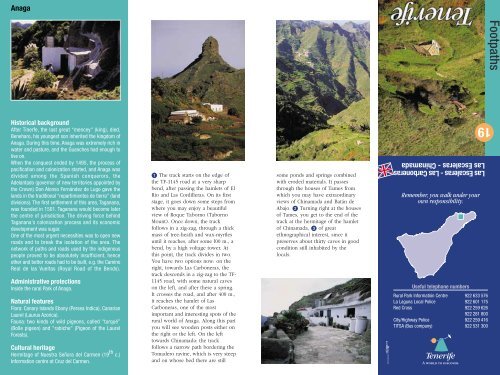
Anaga<br />
Historical background<br />
After Tinerfe, the last great “mencey" (king), died,<br />
Beneharo, his youngest son inherited the kingdom of<br />
Anaga. During this time, Anaga was extremely rich in<br />
water and pasture, and the Guanches had enough to<br />
live on.<br />
When the conquest ended by 1495, the process of<br />
pacification and colonization started, and Anaga was<br />
divided among the Spanish conquerors, the<br />
Adelantado (governor of new territories appointed by<br />
the Crown) Don Alonso Fernández de Lugo gave the<br />
lands in the traditional “repartimientos de tierra" (land<br />
divisions). The first settlement of this area, Taganana,<br />
was founded in 1501. Taganana would become later<br />
the centre of jurisdiction. The driving force behind<br />
Taganana's colonization process and its economic<br />
development was sugar.<br />
One of the most urgent necessities was to open new<br />
roads and to break the isolation of the area. The<br />
network of paths and roads used by the indigenous<br />
people proved to be absolutely insufficient, hence<br />
other and better roads had to be built, e.g. the Camino<br />
Real de las Vueltas (Royal Road of the Bends).<br />
Administrative protections<br />
Inside the rural Park of Anaga.<br />
Natural features<br />
Flora: Canary Islands Ebony (Persea Indica), Canarian<br />
Laurel (Laurus Azorica).<br />
Fauna: two kinds of wild pigeons, called "turqué”<br />
(Bolle pigeon) and "rabiche" (Pigeon of the Laurel<br />
Forests).<br />
Cultural heritage<br />
Hermitage of Nuestra Señora del Carmen (19 th c.)<br />
Information centre at Cruz del Carmen.<br />
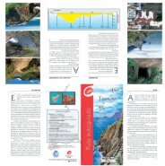
The track starts on the edge of<br />
the TF-1145 road at a very sharp<br />
bend, after passing the hamlets of El<br />
Rio and Las Cordilleras. On its first<br />
stage, it goes down some steps from<br />
where you may enjoy a beautiful<br />
view of Roque Taborno (Taborno<br />
Mount). Once down, the track<br />
follows in a zig-zag, through a thick<br />
mass of tree-heath and wax-myrtles<br />
until it reaches, after some l00 m., a<br />
bend, by a high voltage tower. At<br />
this point, the track divides in two.<br />
You have two options now: on the<br />
right, towards Las Carboneras, the<br />
track descends in a zig-zag to the TF-<br />
1145 road, with some natural caves<br />
on the left, and after these a spring.<br />
It crosses the road, and after 400 m.,<br />
it reaches the hamlet of Las<br />
Carboneras, one of the most<br />
important and interesting spots of the<br />
rural world of Anaga. Along this part<br />
you will see wooden posts either on<br />
the right or the left. On the left<br />
towards Chinamada: the track<br />
follows a narrow path bordering the<br />
Tomadero ravine, which is very steep<br />
and on whose bed there are still<br />
some ponds and springs combined<br />
with eroded materials. It passes<br />
through the houses of Tames from<br />
which you may have extraordinary<br />
views of Chinamada and Batán de<br />
Abajo. Turning right at the houses<br />
of Tames, you get to the end of the<br />
track at the hermitage of the hamlet<br />
of Chinamada, of great<br />
ethnographical interest, since it<br />
preserves about thirty caves in good<br />
condition still inhabited by the<br />
locals.<br />
Las Escaleras - Las Carboneras<br />
Las Escaleras - Chinamada<br />
Remember, you walk under your<br />
own responsibility.<br />
Useful telephone numbers<br />
Rural Park Informatión Centre 922 633 576<br />
La Laguna Local Police 922 601 175<br />
Red Cross 922 259 626<br />
922 281 800<br />
City/Highway Police 922 259 416<br />
TITSA (Bus company) 922 531 300<br />
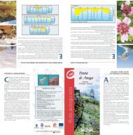
A world to discover.<br />
19<br />
<strong>Footpath</strong>s
Roque Milano<br />
Batán de Abajo<br />
Chinamada<br />
Roque de<br />
los Pinos<br />
Barranco del Tomadero<br />
Tenejías<br />
Batán de Arriba<br />
Viñatigo<br />
Las Escaleras<br />
Las Escaleras<br />
Las Carboneras<br />
El Bailadero (Taganana)<br />
La Cruz del Carmen<br />
TF-1123<br />
◆<br />
Las Escaleras - Las Carboneras<br />
Las Escaleras - Chinamada<br />
Location: Borough of La Laguna<br />
Starting point: Las Escaleras (TF-1145) <br />
Arrival point: Las Carboneras o<br />
Chinamada <br />
Distance: Las Carboneras 1,2 km.<br />
Chinamada 3 km.<br />
Time: Las Carboneras 20 min.<br />
Chinamada 45 min.<br />
Difficulty: Medium<br />
Slope: 100 mts. approx.<br />
Access: TITSA bus routes<br />
+ 3.200<br />
PONDS / POOLS<br />
3.200<br />
CAVE<br />
VIEW POINT<br />
BEACH<br />
RECREATION AREA<br />
SHELTER<br />
LIGHTHOUSE<br />
CRAFTWORK<br />
TRADITIONAL ARCHITECTURE<br />
CHURCH<br />
HISTORIC CENTRE<br />
2.400<br />
1.600<br />
1.200<br />
800<br />
600<br />
0 250 500 M.<br />
400<br />
TOWNHALL<br />
HEALTH CENTRE<br />
BUS STOP<br />
PETROL STATION<br />
INFORMATION<br />
WATER<br />
RESTAURANT<br />
TAXIS<br />
TELEPHONE<br />
PATH<br />
MOTORWAY<br />
MAIN ROAD<br />
ROAD<br />
TRACK - PATH<br />
HOUSE<br />
200<br />
0