Marloth Park Management Plan. - Nkomazi Local Municipality
Marloth Park Management Plan. - Nkomazi Local Municipality Marloth Park Management Plan. - Nkomazi Local Municipality
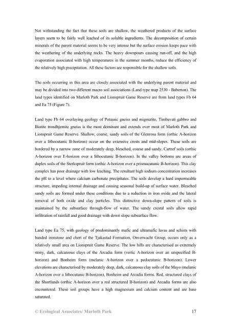
Not withstanding the fact that these soils are shallow, the weathered products of the surface layers seem to be fairly well leached of its soluble ingredients. The decomposition of certain minerals of the parent material seems to be very intense but the surface erosion keeps pace with the weathering of the underlying rocks. The heavy downpours causing run-off, and the high evaporation associated with high temperatures in the summer months, reduce the efficiency of the relatively high precipitation. All these factors are responsible for the shallow soils. The soils occurring in this area are closely associated with the underlying parent material and may be divided into two different macro soil associations (Land type map 2530 - Baberton). The land types identified on Marloth Park and Lionspruit Game Reserve are from land types Fb 64 and Ea 75 (Figure 7). Land type Fb 64 overlaying geology of Potassic gneiss and migmatite, Timbavati gabbro and Biotite trondhjemite gneiss is the most dominant and extends over most of Marloth Park and Lionspruit Game Reserve. Shallow, coarse, sandy soils of the Glenrosa form (orthic A-horizon over a lithocutanic B-horizon) occur on the extensive crests and mid-slopes. These soils are bordered by a narrow zone of moderately deep, bleached, coarse and sandy, Cartref soils (orthic A-horizon over E-horizon over a lithocutanic B-horizon). In the valley bottoms are areas of duplex soils of the Sterkspruit form (orthic A-horizon over a prismacutanic B-horizon). This clay complex has poor drainage with low leaching. The resultant high sodium concentration increases the pH to a level where calcium carbonate precipitates. The soils develop a hard impermeable structure, impeding internal drainage and causing seasonal build-up of surface water. Bleached sandy soils are formed under these conditions due to a reduction in iron oxide and the lateral removal of both oxide and clay particles. This distinctive down-slope pattern of soils is maintained by the subsurface through-flow of water. The sandy crestal soils allow rapid infiltration of rainfall and good drainage with down slope subsurface flow. Land type Ea 75, with geology of predominantly mafic and ultramafic lavas and schists with banded ironstone and chert of the Tjakastad Formation, Onverwacht Group, occurs only as a relatively small area on Lionspruit Game Reserve. The low hills are characterised as extremely stony, dark, calcareous clays of the Arcadia form (vertic A-horizon over an unspecified B- horizon) and Bonheim form (melanic A-horizon over a pedocutanic B-horizon). Lower elevations are characterised by moderately deep, dark, calcareous clay soils of the Mayo (melanic A-horizon over a lithocutanic B-horizon), Bonheim and Arcadia forms. Red, structured clays of the Shortlands (orthic A-horizon over a red structured B-horizon) and Arcadia forms are also encountered. These soil groups have a high magnesium and calcium content and are base saturated. © Ecological Associates/ Marloth Park 17
Figure 7: Land Types of the Marloth Park study area © Ecological Associates/ Marloth Park 18
- Page 1 and 2: Ecological Associates Environmental
- Page 3 and 4: THE ASSESSMENT OF AVAILABLE BROWSE
- Page 5 and 6: LIST OF FIGURES Figure 1: Location
- Page 7 and 8: LIST OF APPENDICES Appendix 1: A li
- Page 9 and 10: Three different scenarios are analy
- Page 11 and 12: Ecosystems disturbed by clearing op
- Page 13 and 14: INTRODUCTION Although only a few ve
- Page 15 and 16: Figure 1: Location of the Marloth P
- Page 17 and 18: GEOMORPHOLOGY Looking down from the
- Page 19 and 20: Figure 4: Geology of the Marloth Pa
- Page 21 and 22: Tonalitic granite and gneiss A sect
- Page 23: Figure 6: Soil depth of the Marloth
- Page 27 and 28: Figure 8: Land use in the Marloth P
- Page 29 and 30: A 610.1 B 104.0 C 7.4 D 19.9 E 39.8
- Page 31 and 32: INTRODUCTION VEGETATION CLASSIFICAT
- Page 33 and 34: METHOD For an initial and broad sca
- Page 35 and 36: RESULTS AND DISCUSSION Analysis and
- Page 37 and 38: The dominant grass species are broa
- Page 39 and 40: The characteristic tree species are
- Page 41 and 42: VELD CONDITION ASSESSMENT AND THE C
- Page 43 and 44: Degradation gradients are models th
- Page 45 and 46: The nearest grass species to each s
- Page 47 and 48: Calculation of grazing capacity The
- Page 49 and 50: Table 2: Contribution of ecological
- Page 51 and 52: Table 3: Grazing capacities for the
- Page 53 and 54: THE ASSESSMENT OF AVAILABLE BROWSE
- Page 55 and 56: X Y D1 Y Dimensional measurements:
- Page 57 and 58: RESULTS AND DISCUSSION The browsing
- Page 59 and 60: Table 6: Browsing capacities for th
- Page 61 and 62: INTRODUCTION ESTIMATION OF HERBACEO
- Page 63 and 64: The resulting Large Stock Units are
- Page 65 and 66: INTRODUCTION GAME MANAGEMENT ON MAR
- Page 67 and 68: STOCKING RATES Current stocking The
- Page 69 and 70: Table 10: The current stocking dens
- Page 71 and 72: Recommendations on stocking rates C
- Page 73 and 74: High selectivity grazers Blue wilde
Not withstanding the fact that these soils are shallow, the weathered products of the surface<br />
layers seem to be fairly well leached of its soluble ingredients. The decomposition of certain<br />
minerals of the parent material seems to be very intense but the surface erosion keeps pace with<br />
the weathering of the underlying rocks. The heavy downpours causing run-off, and the high<br />
evaporation associated with high temperatures in the summer months, reduce the efficiency of<br />
the relatively high precipitation. All these factors are responsible for the shallow soils.<br />
The soils occurring in this area are closely associated with the underlying parent material and<br />
may be divided into two different macro soil associations (Land type map 2530 - Baberton). The<br />
land types identified on <strong>Marloth</strong> <strong>Park</strong> and Lionspruit Game Reserve are from land types Fb 64<br />
and Ea 75 (Figure 7).<br />
Land type Fb 64 overlaying geology of Potassic gneiss and migmatite, Timbavati gabbro and<br />
Biotite trondhjemite gneiss is the most dominant and extends over most of <strong>Marloth</strong> <strong>Park</strong> and<br />
Lionspruit Game Reserve. Shallow, coarse, sandy soils of the Glenrosa form (orthic A-horizon<br />
over a lithocutanic B-horizon) occur on the extensive crests and mid-slopes. These soils are<br />
bordered by a narrow zone of moderately deep, bleached, coarse and sandy, Cartref soils (orthic<br />
A-horizon over E-horizon over a lithocutanic B-horizon). In the valley bottoms are areas of<br />
duplex soils of the Sterkspruit form (orthic A-horizon over a prismacutanic B-horizon). This clay<br />
complex has poor drainage with low leaching. The resultant high sodium concentration increases<br />
the pH to a level where calcium carbonate precipitates. The soils develop a hard impermeable<br />
structure, impeding internal drainage and causing seasonal build-up of surface water. Bleached<br />
sandy soils are formed under these conditions due to a reduction in iron oxide and the lateral<br />
removal of both oxide and clay particles. This distinctive down-slope pattern of soils is<br />
maintained by the subsurface through-flow of water. The sandy crestal soils allow rapid<br />
infiltration of rainfall and good drainage with down slope subsurface flow.<br />
Land type Ea 75, with geology of predominantly mafic and ultramafic lavas and schists with<br />
banded ironstone and chert of the Tjakastad Formation, Onverwacht Group, occurs only as a<br />
relatively small area on Lionspruit Game Reserve. The low hills are characterised as extremely<br />
stony, dark, calcareous clays of the Arcadia form (vertic A-horizon over an unspecified B-<br />
horizon) and Bonheim form (melanic A-horizon over a pedocutanic B-horizon). Lower<br />
elevations are characterised by moderately deep, dark, calcareous clay soils of the Mayo (melanic<br />
A-horizon over a lithocutanic B-horizon), Bonheim and Arcadia forms. Red, structured clays of<br />
the Shortlands (orthic A-horizon over a red structured B-horizon) and Arcadia forms are also<br />
encountered. These soil groups have a high magnesium and calcium content and are base<br />
saturated.<br />
© Ecological Associates/ <strong>Marloth</strong> <strong>Park</strong> 17


