- Page 4 and 5:
AUGUST 2005 FINAL REPORT STATEMENT
- Page 6 and 7:
AUGUST 2005 FINAL REPORT EXECUTIVE
- Page 8 and 9:
AUGUST 2005 FINAL REPORT ACKNOWLEDG
- Page 10 and 11:
AUGUST 2005 FINAL REPORT TABLE OF C
- Page 12 and 13:
AUGUST 2005 FINAL REPORT TABLE OF C
- Page 14 and 15:
AUGUST 2005 FINAL REPORT LIST OF FI
- Page 16 and 17:
AUGUST 2005 FINAL REPORT LIST OF TA
- Page 18 and 19:
AUGUST 2005 FINAL REPORT LIST OF AC
- Page 20 and 21:
AUGUST 2005 FINAL REPORT LIST OF AC
- Page 22 and 23:
AUGUST 2005 FINAL REPORT 1.0 INTROD
- Page 24 and 25:
AUGUST 2005 FINAL REPORT (out to 1
- Page 26 and 27:
AUGUST 2005 FINAL REPORT act that i
- Page 28 and 29:
AUGUST 2005 FINAL REPORT Table 1-1.
- Page 30 and 31:
AUGUST 2005 FINAL REPORT includes t
- Page 32 and 33:
AUGUST 2005 FINAL REPORT Bibliograp
- Page 34 and 35:
AUGUST 2005 FINAL REPORT ESRI's pro
- Page 36 and 37:
AUGUST 2005 FINAL REPORT different
- Page 38 and 39:
AUGUST 2005 FINAL REPORT Commonweal
- Page 40 and 41:
AUGUST 2005 FINAL REPORT 2.0 PHYSIC
- Page 42 and 43:
AUGUST 2005 FINAL REPORT During La
- Page 44 and 45:
AUGUST 2005 FINAL REPORT Figure 2-2
- Page 46 and 47:
AUGUST 2005 FINAL REPORT Figure 2-3
- Page 48 and 49:
AUGUST 2005 FINAL REPORT of the wat
- Page 50 and 51:
AUGUST 2005 FINAL REPORT Figure 2-4
- Page 52 and 53:
AUGUST 2005 FINAL REPORT 2-13 Figur
- Page 54 and 55:
AUGUST 2005 FINAL REPORT nutrient r
- Page 56 and 57:
AUGUST 2005 FINAL REPORT The NEC, w
- Page 58 and 59:
AUGUST 2005 FINAL REPORT 2.7 COASTA
- Page 60 and 61:
AUGUST 2005 FINAL REPORT Figure 2-7
- Page 62 and 63:
AUGUST 2005 FINAL REPORT Figure 2-7
- Page 64 and 65:
AUGUST 2005 FINAL REPORT Figure 2-8
- Page 66 and 67:
AUGUST 2005 FINAL REPORT Figure 2-9
- Page 68 and 69:
AUGUST 2005 FINAL REPORT Figure 2-9
- Page 70 and 71:
AUGUST 2005 FINAL REPORT during hea
- Page 72 and 73:
AUGUST 2005 FINAL REPORT Corals als
- Page 74 and 75:
AUGUST 2005 FINAL REPORT massive co
- Page 76 and 77:
AUGUST 2005 FINAL REPORT seagrass c
- Page 78 and 79:
AUGUST 2005 FINAL REPORT The topogr
- Page 80 and 81:
AUGUST 2005 FINAL REPORT The island
- Page 82 and 83:
AUGUST 2005 FINAL REPORT totaling a
- Page 84 and 85:
AUGUST 2005 FINAL REPORT Figure 2-1
- Page 86 and 87:
AUGUST 2005 FINAL REPORT Artificial
- Page 88 and 89:
AUGUST 2005 FINAL REPORT Fedorov, V
- Page 90 and 91:
AUGUST 2005 FINAL REPORT Martinez,
- Page 92 and 93:
AUGUST 2005 FINAL REPORT Randall, R
- Page 94 and 95:
AUGUST 2005 FINAL REPORT Uchida, R.
- Page 96 and 97:
AUGUST 2005 FINAL REPORT 3.0 SPECIE
- Page 98 and 99:
AUGUST 2005 FINAL REPORT 3.1 MARINE
- Page 100 and 101:
AUGUST 2005 FINAL REPORT be ones in
- Page 102 and 103:
AUGUST 2005 FINAL REPORT Gannier (2
- Page 104 and 105:
AUGUST 2005 FINAL REPORT whale sigh
- Page 106 and 107:
AUGUST 2005 FINAL REPORT Morphometr
- Page 108 and 109:
AUGUST 2005 FINAL REPORT Figure 3-1
- Page 110 and 111:
AUGUST 2005 FINAL REPORT Acoustics
- Page 112 and 113:
AUGUST 2005 FINAL REPORT widespread
- Page 114 and 115:
AUGUST 2005 FINAL REPORT in the Mic
- Page 116 and 117:
AUGUST 2005 FINAL REPORT where sper
- Page 118 and 119:
AUGUST 2005 FINAL REPORT 3-23 Figur
- Page 120 and 121:
AUGUST 2005 FINAL REPORT brief gutt
- Page 122 and 123:
AUGUST 2005 FINAL REPORT coloration
- Page 124 and 125:
AUGUST 2005 FINAL REPORT catches al
- Page 126 and 127:
AUGUST 2005 FINAL REPORT 1991, 2003
- Page 128 and 129:
AUGUST 2005 FINAL REPORT MacLeod et
- Page 130 and 131:
AUGUST 2005 FINAL REPORT ♦ Hubbs
- Page 132 and 133:
AUGUST 2005 FINAL REPORT range for
- Page 134 and 135:
AUGUST 2005 FINAL REPORT (Natoli et
- Page 136 and 137:
AUGUST 2005 FINAL REPORT Tursiops a
- Page 138 and 139:
AUGUST 2005 FINAL REPORT ♦ Spinne
- Page 140 and 141:
AUGUST 2005 FINAL REPORT Spinner do
- Page 142 and 143:
AUGUST 2005 FINAL REPORT black to d
- Page 144 and 145:
AUGUST 2005 FINAL REPORT (Corkeron
- Page 146 and 147:
AUGUST 2005 FINAL REPORT and vicini
- Page 148 and 149:
AUGUST 2005 FINAL REPORT Behavior a
- Page 150 and 151:
AUGUST 2005 FINAL REPORT ♦ Short-
- Page 152 and 153:
AUGUST 2005 FINAL REPORT Habitat Pr
- Page 154 and 155:
AUGUST 2005 FINAL REPORT 147 to 334
- Page 156 and 157:
AUGUST 2005 FINAL REPORT Baird, R.W
- Page 158 and 159:
AUGUST 2005 FINAL REPORT Calambokid
- Page 160 and 161:
AUGUST 2005 FINAL REPORT Darling, J
- Page 162 and 163:
AUGUST 2005 FINAL REPORT Gallo-Reyn
- Page 164 and 165:
AUGUST 2005 FINAL REPORT Ivashin, M
- Page 166 and 167:
AUGUST 2005 FINAL REPORT Lafortuna,
- Page 168 and 169:
AUGUST 2005 FINAL REPORT Mate, B.R.
- Page 170 and 171:
AUGUST 2005 FINAL REPORT Moore, S.E
- Page 172 and 173:
AUGUST 2005 FINAL REPORT Palacios,
- Page 174 and 175:
AUGUST 2005 FINAL REPORT Pryor, K.,
- Page 176 and 177:
AUGUST 2005 FINAL REPORT Schilling,
- Page 178 and 179:
AUGUST 2005 FINAL REPORT Thode, A.,
- Page 180 and 181:
AUGUST 2005 FINAL REPORT Watkins, W
- Page 182 and 183:
AUGUST 2005 FINAL REPORT 3.2 SEA TU
- Page 184 and 185:
AUGUST 2005 FINAL REPORT levels in
- Page 186 and 187:
AUGUST 2005 FINAL REPORT 3-91 Figur
- Page 188 and 189:
AUGUST 2005 FINAL REPORT are locate
- Page 190 and 191:
AUGUST 2005 FINAL REPORT CNMI Divis
- Page 192 and 193:
AUGUST 2005 FINAL REPORT area water
- Page 194 and 195:
AUGUST 2005 FINAL REPORT the centra
- Page 196 and 197:
AUGUST 2005 FINAL REPORT margins. I
- Page 198 and 199:
AUGUST 2005 FINAL REPORT migrations
- Page 200 and 201:
AUGUST 2005 FINAL REPORT Balazs, G.
- Page 202 and 203:
AUGUST 2005 FINAL REPORT Dutton, P.
- Page 204 and 205:
AUGUST 2005 FINAL REPORT Lewison, R
- Page 206 and 207:
AUGUST 2005 FINAL REPORT Pitman, R.
- Page 208 and 209:
AUGUST 2005 FINAL REPORT 4.0 FISH A
- Page 210 and 211:
AUGUST 2005 FINAL REPORT EFH specie
- Page 212 and 213:
AUGUST 2005 FINAL REPORT Table 4-1.
- Page 214 and 215:
AUGUST 2005 FINAL REPORT Seaward re
- Page 216 and 217:
AUGUST 2005 FINAL REPORT Currently,
- Page 218 and 219:
AUGUST 2005 FINAL REPORT Table 4-3.
- Page 220 and 221:
AUGUST 2005 FINAL REPORT Table 4-4.
- Page 222 and 223:
AUGUST 2005 FINAL REPORT Table 4-5.
- Page 224 and 225:
AUGUST 2005 FINAL REPORT Table 4-5.
- Page 226 and 227:
AUGUST 2005 FINAL REPORT Table 4-5.
- Page 228 and 229:
AUGUST 2005 FINAL REPORT The grey r
- Page 230 and 231:
AUGUST 2005 FINAL REPORT Habitat Pr
- Page 232 and 233:
AUGUST 2005 FINAL REPORT night (Fro
- Page 234 and 235:
AUGUST 2005 FINAL REPORT ♦ Muraen
- Page 236 and 237:
AUGUST 2005 FINAL REPORT they enter
- Page 238 and 239:
AUGUST 2005 FINAL REPORT The bumphe
- Page 240 and 241:
AUGUST 2005 FINAL REPORT within lag
- Page 242 and 243:
AUGUST 2005 FINAL REPORT Achilles
- Page 244 and 245:
AUGUST 2005 FINAL REPORT The longno
- Page 246 and 247:
AUGUST 2005 FINAL REPORT The humbug
- Page 248 and 249:
AUGUST 2005 FINAL REPORT ♦ Dasyat
- Page 250 and 251:
AUGUST 2005 FINAL REPORT with a few
- Page 252 and 253:
AUGUST 2005 FINAL REPORT Life Histo
- Page 254 and 255: AUGUST 2005 FINAL REPORT NMFS 2004c
- Page 256 and 257: AUGUST 2005 FINAL REPORT Donaldson
- Page 258 and 259: AUGUST 2005 FINAL REPORT Distributi
- Page 260 and 261: AUGUST 2005 FINAL REPORT Habitat Pr
- Page 262 and 263: AUGUST 2005 FINAL REPORT outer slop
- Page 264 and 265: AUGUST 2005 FINAL REPORT ♦ Bryozo
- Page 266 and 267: AUGUST 2005 FINAL REPORT 2001; NMFS
- Page 268 and 269: AUGUST 2005 FINAL REPORT in deepwat
- Page 270 and 271: AUGUST 2005 FINAL REPORT 4.3 FISHER
- Page 272 and 273: AUGUST 2005 FINAL REPORT Pounds (10
- Page 274 and 275: AUGUST 2005 FINAL REPORT 1000 Pound
- Page 276 and 277: AUGUST 2005 FINAL REPORT Blue Marli
- Page 278 and 279: AUGUST 2005 FINAL REPORT Annual tro
- Page 280 and 281: AUGUST 2005 FINAL REPORT hour trips
- Page 282 and 283: AUGUST 2005 FINAL REPORT Bottomfish
- Page 284 and 285: AUGUST 2005 FINAL REPORT Table 4-6.
- Page 286 and 287: AUGUST 2005 FINAL REPORT In the CNM
- Page 288 and 289: AUGUST 2005 FINAL REPORT Chan, T.Y.
- Page 290 and 291: AUGUST 2005 FINAL REPORT Feltes, R.
- Page 292 and 293: AUGUST 2005 FINAL REPORT Larson, H.
- Page 294 and 295: AUGUST 2005 FINAL REPORT NMFS (Nati
- Page 296 and 297: AUGUST 2005 FINAL REPORT Randall, J
- Page 298 and 299: AUGUST 2005 FINAL REPORT Starnes, W
- Page 300 and 301: AUGUST 2005 FINAL REPORT WPRFMC (We
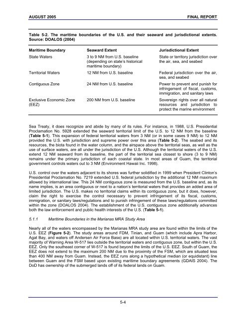
- Page 302 and 303: AUGUST 2005 FINAL REPORT 5.0 ADDITI
- Page 306 and 307: AUGUST 2005 FINAL REPORT Figure 5-2
- Page 308 and 309: AUGUST 2005 FINAL REPORT Figure 5-3
- Page 310 and 311: AUGUST 2005 FINAL REPORT The first
- Page 312 and 313: AUGUST 2005 FINAL REPORT park. Coas
- Page 314 and 315: AUGUST 2005 FINAL REPORT There is a
- Page 316 and 317: AUGUST 2005 FINAL REPORT 5.5 LITERA
- Page 318 and 319: AUGUST 2005 FINAL REPORT 6.0 RECOMM
- Page 320 and 321: AUGUST 2005 FINAL REPORT • Suppor
- Page 322 and 323: AUGUST 2005 FINAL REPORT 6.3 LITERA
- Page 324 and 325: AUGUST 2005 FINAL REPORT 7.0 LIST O
- Page 326 and 327: AUGUST 2005 FINAL REPORT 8.0 GLOSSA
- Page 328 and 329: AUGUST 2005 FINAL REPORT Benthonic
- Page 330 and 331: AUGUST 2005 FINAL REPORT Clutch—a
- Page 332 and 333: AUGUST 2005 FINAL REPORT Cryptofaun
- Page 334 and 335: AUGUST 2005 FINAL REPORT Endangered
- Page 336 and 337: AUGUST 2005 FINAL REPORT Fringing r
- Page 338 and 339: AUGUST 2005 FINAL REPORT Incidental
- Page 340 and 341: AUGUST 2005 FINAL REPORT Melon—a
- Page 342 and 343: AUGUST 2005 FINAL REPORT Omnivore
- Page 344 and 345: AUGUST 2005 FINAL REPORT Predation
- Page 346 and 347: AUGUST 2005 FINAL REPORT Sessile—
- Page 348 and 349: AUGUST 2005 FINAL REPORT Surge—lo
- Page 350 and 351: AUGUST 2005 FINAL REPORT Whistle—
- Page 352 and 353: AUGUST 2005 FINAL REPORT APPENDIX A
- Page 354 and 355:
AUGUST 2005 FINAL REPORT Appendix A
- Page 356 and 357:
AUGUST 2005 FINAL REPORT Appendix A
- Page 358 and 359:
AUGUST 2005 FINAL REPORT were provi
- Page 360 and 361:
AUGUST 2005 FINAL REPORT Protected
- Page 362 and 363:
AUGUST 2005 FINAL REPORT DoN (Depar
- Page 364 and 365:
AUGUST 2005 FINAL REPORT Figure Tit
- Page 366 and 367:
AUGUST 2005 FINAL REPORT Figure B-2
- Page 368 and 369:
AUGUST 2005 FINAL REPORT Figure B-4
- Page 370 and 371:
AUGUST 2005 FINAL REPORT Figure B-6
- Page 372 and 373:
AUGUST 2005 FINAL REPORT Figure B-8
- Page 374 and 375:
AUGUST 2005 FINAL REPORT Figure B-1
- Page 376 and 377:
AUGUST 2005 FINAL REPORT Figure B-1
- Page 378 and 379:
AUGUST 2005 FINAL REPORT Figure B-1
- Page 380 and 381:
AUGUST 2005 FINAL REPORT Figure B-1
- Page 382 and 383:
AUGUST 2005 FINAL REPORT Figure B-1
- Page 384 and 385:
AUGUST 2005 FINAL REPORT Figure B-2
- Page 386 and 387:
AUGUST 2005 FINAL REPORT Figure B-2
- Page 388 and 389:
AUGUST 2005 FINAL REPORT Figure B-2
- Page 390 and 391:
AUGUST 2005 FINAL REPORT Figure C-1
- Page 392 and 393:
AUGUST 2005 FINAL REPORT Figure C-3
- Page 394 and 395:
AUGUST 2005 FINAL REPORT Figure C-5
- Page 396 and 397:
AUGUST 2005 FINAL REPORT Figure Tit
- Page 398 and 399:
AUGUST 2005 FINAL REPORT Figure D-2
- Page 400 and 401:
AUGUST 2005 FINAL REPORT Figure D-4
- Page 402 and 403:
AUGUST 2005 FINAL REPORT Figure D-6
- Page 404 and 405:
AUGUST 2005 FINAL REPORT Figure D-8
- Page 406 and 407:
AUGUST 2005 FINAL REPORT Figure D-1
- Page 408 and 409:
AUGUST 2005 FINAL REPORT Figure D-1
- Page 410 and 411:
AUGUST 2005 FINAL REPORT Figure D-1
- Page 412 and 413:
AUGUST 2005 FINAL REPORT Figure D-1
- Page 414 and 415:
AUGUST 2005 FINAL REPORT Figure D-1
- Page 416:
AUGUST 2005 FINAL REPORT Figure D-2