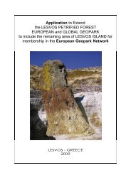
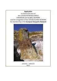
Applicatopn dossier for nomination as a European Geopark ...
Applicatopn dossier for nomination as a European Geopark ...
Applicatopn dossier for nomination as a European Geopark ...

You also want an ePaper? Increase the reach of your titles
YUMPU automatically turns print PDFs into web optimized ePapers that Google loves.
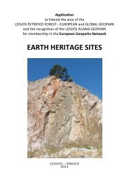
Karstic gypsums border a bowl of the lake<br />
B<strong>as</strong>kunchack non-uni<strong>for</strong>mly. I.V.Golovachyov offered<br />
the following allocation of karstic fields. Northern field<br />
surrounds a bowl of B<strong>as</strong>kunchack from the west, the<br />
north and the northe<strong>as</strong>t. It is conditionally shared into<br />
three parts: western – from the gully Belaya (Ak -<br />
Dzhar) to the south and west in borders of Kungurian<br />
gypsums extension; northern (or central) field extends<br />
from the gully Belaya to the e<strong>as</strong>t up to the lake Kar<strong>as</strong>un<br />
and to the north up to the lake Turgaj; the e<strong>as</strong>t field<br />
extends to the northe<strong>as</strong>t co<strong>as</strong>t of the lake B<strong>as</strong>kunchack<br />
between the river Gorkaya and the lake Kar<strong>as</strong>un. The<br />
e<strong>as</strong>t field is bordered from the northern field by the river<br />
Gorkaya and also l<strong>as</strong>ts to the e<strong>as</strong>t in borders of<br />
Kungurian gypsums extension. It consists of two<br />
detached closely spaced sections: Vac - Tausk and<br />
T<strong>as</strong>bulack. The southern field is located on the<br />
southern co<strong>as</strong>t of B<strong>as</strong>kunchack, to the e<strong>as</strong>t of Bolshoye<br />
Bogdo. Except <strong>for</strong> these three karstic fields the karstic<br />
removed and detached Cub- Тausk section is allocated.<br />
In the territory of the lake B<strong>as</strong>kunchack vicinities there<br />
are following <strong>for</strong>ms of a karstic relief:<br />
1. The negative superficial <strong>for</strong>ms of the given area<br />
karstic relief are: corries, craters, hollows, gullies.<br />
2. Gypsum hills with the height of up to 4,0 - 6,0m.,<br />
extended from the northe<strong>as</strong>t to the southwest on the<br />
northern and the northe<strong>as</strong>t co<strong>as</strong>t of the lake<br />
B<strong>as</strong>kunchack.<br />
3. Grottoes, niches, shelters (Transitive <strong>for</strong>ms from<br />
superficial karstic <strong>for</strong>ms to underground ones). On the<br />
researched area, within the limits of the northern<br />
gypsum field there are three grottoes: "Lisiy",<br />
"Koljuchiy" and "Sharovskoy".<br />
4. To underground karstic relief in the given area the<br />
following <strong>for</strong>ms can be concerned: karst cracks, karstic<br />
wells and caves.<br />
7<br />
Karst cracks are the most typical <strong>for</strong> the natural<br />
boundary Sharbulack on the southern gypsum field,<br />
and also <strong>for</strong> the central part of the northern gypsum<br />
field. Tectonic cracks (<strong>for</strong>med owing to salt domn<br />
tectonics) are poorly treated by karstic processes.<br />
Mainly they are strongly attached to the raised<br />
sections raised and gypsum hills. The width of<br />
cracks, <strong>as</strong> a rule, is not great (up to 0,4 - 0,6m.).<br />
They have the depth up to 4,0 - 6,0m., and even<br />
more. So, the disconnected crack «Grelka", h<strong>as</strong> the<br />
depth up to 12,5m. Bottoms of cracks are usually<br />
filled by detrital gypsums and friable alluvial sandy<br />
material.<br />
Karst wells. To karstic wells, the vertical cavities<br />
connected to the zone of vertical descending<br />
circulation of karstic waters concern. Depth of wells is<br />
up to 20,0m. Wells of the given area have a<br />
corrosion-erosive origin. They can be fragments of<br />
buried cavities, or the expanded channels of well -<br />
imaginative swallow holes. Wells are available in the<br />
central part of the northern gypsum field. Depth of<br />
them, <strong>as</strong> a rule, is not great - about 4,0 - 6,0m, width<br />
is about 1,0 - 2,0m, cross section is roundish. On<br />
subsurfaces channel corries can be met.<br />
B 2.8. Caves of corrosion – erosion type<br />
Cave Sharbulack.<br />
The entrance is situated in the natural hole<br />
Sharbulack, in the edge of karst-erosive hollow; it<br />
opens with a small descending window. The cave<br />
represents a twisting horizontal tailrace channel<br />
underrated in the distant part. The height of the<br />
entrance reaches 1,5m. The extension of the cave is<br />
about 40m. The maximal depth of the cave bedding<br />
from the steppe level is about 30m. In 2007 owing to<br />
entrance failure the cave became inaccessible <strong>for</strong><br />
visiting.<br />
Cave Grobick. The entrance is situated in the natural<br />
hole Sharbulack in gypsum exposure. The cave<br />
represents a vertical crack with a horizontal bottom.<br />
Between vertical walls in 4,5m above the floor there<br />
is a large wedged gypsum block which teared off the<br />
arch and looks like a coffin. The maximum height of<br />
the entrance is 7,5m. Be<strong>for</strong>e the creation of the state<br />
reserve the cave had been actively visited by tourists.<br />
Cave Cherep. The entrance of the cave is situated in<br />
the natural hole Sharbulack, in a slope of karstic<br />
crater; it is submitted with a small entrance grotto<br />
with a height of 2,5m and width of 3m. In the depth of<br />
the grotto the block with the inscription and the image<br />
of a skull with bones is located. In the beginning of<br />
the l<strong>as</strong>t century the cave w<strong>as</strong> named « Forty doors ».