Furnace of Creation, Cradle of Destruction: A Journey to the ...
Furnace of Creation, Cradle of Destruction: A Journey to the ...
Furnace of Creation, Cradle of Destruction: A Journey to the ...

You also want an ePaper? Increase the reach of your titles
YUMPU automatically turns print PDFs into web optimized ePapers that Google loves.
<strong>Furnace</strong> <strong>of</strong> <strong>Creation</strong><br />
<strong>Cradle</strong> <strong>of</strong> <strong>Destruction</strong>
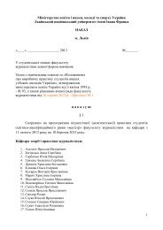
Frontispiece <strong>to</strong> Thomas Burnet’s The Sacred Theory <strong>of</strong> <strong>the</strong> Earth,<br />
published in 1681.<br />
According <strong>to</strong> <strong>the</strong> model proposed by Burnet, <strong>the</strong> antediluvian earth was a smooth<br />
ovoid, or egg, with a uniform texture. When <strong>the</strong> Flood came, sections <strong>of</strong> a weakened<br />
crust cracked open, exposing <strong>the</strong> water layer beneath. Some <strong>of</strong> <strong>the</strong> cracked<br />
crust fell in<strong>to</strong> <strong>the</strong> interior and <strong>the</strong> Flood waters burst on<strong>to</strong> <strong>the</strong> surface. In this process,<br />
mountains were upturned fragments <strong>of</strong> <strong>the</strong> early crust left behind after <strong>the</strong><br />
Deluge, and oceans were holes left where <strong>the</strong> crust broke up. This was one <strong>of</strong> <strong>the</strong><br />
first <strong>the</strong>ories on <strong>the</strong> formation <strong>of</strong> <strong>the</strong> earth’s features that attempted <strong>to</strong> reconcile<br />
<strong>the</strong> views <strong>of</strong> <strong>the</strong> Church and Science.
<strong>Furnace</strong> <strong>of</strong> <strong>Creation</strong><br />
<br />
<strong>Cradle</strong> <strong>of</strong><br />
<strong>Destruction</strong><br />
A <strong>Journey</strong> <strong>to</strong> <strong>the</strong> Birthplace <strong>of</strong> Earthquakes,<br />
Volcanoes, and Tsunamis<br />
Roy Chester, Ph.D.<br />
American Management Association<br />
New York * Atlanta * Brussels * Chicago * Mexico City * San Francisco<br />
Shanghai * Tokyo * Toron<strong>to</strong> * Washing<strong>to</strong>n, D.C.
Special discounts on bulk quantities <strong>of</strong> AMACOM books are<br />
available <strong>to</strong> corporations, pr<strong>of</strong>essional associations, and o<strong>the</strong>r<br />
organizations. For details, contact Special Sales Department,<br />
AMACOM, adivision <strong>of</strong> American Management Association,<br />
1601 Broadway, New York, NY 10019.<br />
Tel.: 212-903-8316 Fax: 212-903-8083<br />
E-mail: specialsls@amanet.org<br />
Website: www.amacombooks.org/go/specialsales<br />
To view all AMACOM titles go <strong>to</strong>: www.amacombooks.org<br />
This publication is designed <strong>to</strong> provide accurate and authoritative<br />
information in regard <strong>to</strong> <strong>the</strong> subject matter covered. It is sold with <strong>the</strong><br />
understanding that <strong>the</strong> publisher is not engaged in rendering legal,<br />
accounting, or o<strong>the</strong>r pr<strong>of</strong>essional service.Iflegal advice or o<strong>the</strong>r expert<br />
assistance is required, <strong>the</strong> services <strong>of</strong> a competent pr<strong>of</strong>essional person<br />
should be sought.<br />
Library <strong>of</strong> Congress Cataloging-in-Publication Data<br />
Chester, R. (Roy), 1936–<br />
<strong>Furnace</strong> <strong>of</strong> creation, cradle <strong>of</strong> destruction : a journey <strong>to</strong> <strong>the</strong> birthplace <strong>of</strong> earthquakes,<br />
volcanoes, and tsunamis /Roy Chester.<br />
p. cm.<br />
Includes index.<br />
ISBN-13: 978-0-8144-0920-6<br />
ISBN-10: 0-8144-0920-2<br />
1. Plate tec<strong>to</strong>nics. 2. Continental drift. I. Title.<br />
QE511.4.C44 2008<br />
551.136—dc22 2008012702<br />
2008 Roy Chester.<br />
All rights reserved.<br />
Printed in <strong>the</strong> United States <strong>of</strong> America.<br />
This publication may not be reproduced, s<strong>to</strong>red in a retrieval system, or transmitted in<br />
whole or in part, in any form or by any means, electronic, mechanical, pho<strong>to</strong>copying,<br />
recording, or o<strong>the</strong>rwise, without <strong>the</strong> prior written permission <strong>of</strong> AMACOM, adivision <strong>of</strong><br />
American Management Association, 1601 Broadway, New York, NY 10019.<br />
Printing number<br />
10 9 8 7 6 5 4 3 2 1
To Oliver, Edward, and Henry<br />
‘‘The next generation’’
This page intentionally left blank
CONTENTS<br />
ACKNOWLEDGMENTS xi<br />
INTRODUCTION<br />
The Time Before Science 1<br />
CHAPTER 1: Setting <strong>the</strong> Scene 4<br />
The Trinity <strong>of</strong> Natural Disasters 4<br />
Myths and Legends 4<br />
CHAPTER 2: Beginnings 19<br />
What Is <strong>the</strong> Structure <strong>of</strong> <strong>the</strong> Earth? 21<br />
How Old Is <strong>the</strong> Earth? 23<br />
Has <strong>the</strong> Earth Changed During Its His<strong>to</strong>ry? 26<br />
CHAPTER 3: New Battles 32<br />
The Rocks <strong>of</strong> <strong>the</strong> Earth 32<br />
The Battle Is Joined 34<br />
New Horizons 40<br />
CHAPTER 4: Toward Continental Drift 46<br />
Important Ideas 46<br />
The Contracting Earth 46<br />
The Land Beneath <strong>the</strong> Sea 50<br />
CHAPTER 5: On <strong>the</strong> Road <strong>to</strong> Explaining Volcanoes,<br />
Earthquakes, and Tsunamis 55<br />
Volcanoes 55<br />
Earthquakes 63<br />
vii
CONTENTS<br />
Tsunamis 78<br />
The Next Stage 85<br />
CHAPTER 6: Continental Drift: A Theory Without<br />
a Cause 86<br />
A Big Debate 86<br />
Isostasy 87<br />
Continental Drift 88<br />
In <strong>the</strong> Shadow <strong>of</strong> Continental Drift 92<br />
CHAPTER 7: New Horizons 97<br />
The Challenge <strong>of</strong> <strong>the</strong> Sea 97<br />
Mapping <strong>the</strong> Ocean Floor 99<br />
CHAPTER 8: Seafloor Spreading 103<br />
A Theory Emerges 103<br />
A Theory Comes <strong>of</strong> Age 104<br />
The Paleomagnetic Key 109<br />
How Fast Does It Work? 112<br />
CHAPTER 9: The Plot Thickens 114<br />
Deep-Sea Sedimentation 114<br />
Probing <strong>the</strong> Sediment Blanket 118<br />
The His<strong>to</strong>ry <strong>of</strong> <strong>the</strong> Seabed 119<br />
CHAPTER 10: The Cycle <strong>of</strong> Birth, Life, and<br />
<strong>Destruction</strong> 123<br />
The Dynamics <strong>of</strong> Seafloor Spreading 123<br />
CHAPTER 11: Plate Tec<strong>to</strong>nics: The Earth Science<br />
‘‘Theory <strong>of</strong> Everything’’ 130<br />
A Great Leap Forward 130<br />
viii
CONTENTS<br />
Transform Faults and New Ideas 130<br />
Plates and ‘‘Plate Tec<strong>to</strong>nics’’ 134<br />
The Theory <strong>of</strong> Everything? 140<br />
CHAPTER 12: Hydro<strong>the</strong>rmal Activity: A New Ocean<br />
World 143<br />
The Thin Red Layer 143<br />
The Lost Heat 144<br />
Exploring <strong>the</strong> Mid-Ocean Ridges 145<br />
A New World 146<br />
The Pieces Begin <strong>to</strong> Fit Toge<strong>the</strong>r 146<br />
Diversity: ‘‘Black Smokers’’ and ‘‘White Smokers’’ 147<br />
Vent Communities 150<br />
Safe Havens and <strong>the</strong> Origin <strong>of</strong> Life 152<br />
CHAPTER 13: Plate Tec<strong>to</strong>nics and Volcanoes 157<br />
CHAPTER 14: Plate Tec<strong>to</strong>nics and Earthquakes 169<br />
CHAPTER 15: Plate Tec<strong>to</strong>nics and Tsunamis 174<br />
CHAPTER 16: Predicting and Mitigating Against<br />
Volcanoes, Earthquakes, and Tsunamis 177<br />
Volcanoes: ‘‘Fire and Molten Rock’’ 180<br />
Earthquakes: ‘‘When <strong>the</strong> Earth Moves’’ 187<br />
Tsunamis: ‘‘The Big Wave’’ 206<br />
Coping with Natural Disasters 221<br />
EPILOGUE<br />
Deadly Years and Megadisasters 223<br />
ix
CONTENTS<br />
Change 223<br />
The Year 2004 223<br />
Megadisasters 224<br />
INDEX 227<br />
x
ACKNOWLEDGMENTS<br />
Iwould like <strong>to</strong> express my personal thanks <strong>to</strong> my long-suffering<br />
wife, Alison. Writing is a lonely business and she has, as usual,<br />
s<strong>to</strong>ically put up with my ‘‘absences’’ from normal family life as I<br />
have shut myself away for periods <strong>of</strong> time that seem <strong>to</strong> increase<br />
exponentially as deadlines approach.<br />
I am grateful <strong>to</strong> those individuals, and organizations, who<br />
kindly gave permission for <strong>the</strong> reproduction <strong>of</strong> figures, and I have<br />
been happy <strong>to</strong> credit each one at <strong>the</strong> appropriate place in <strong>the</strong> text.<br />
My particular thanks go <strong>to</strong> Pr<strong>of</strong>essor Steven Nelson for generously<br />
allowing me <strong>to</strong> use so many <strong>of</strong> his diagrams, and <strong>to</strong> <strong>the</strong> United<br />
States Geological Survey for making available <strong>the</strong> range <strong>of</strong> figures<br />
from its collection. I would also like <strong>to</strong> acknowledge my debt <strong>to</strong><br />
Jennifer Holder, whose edi<strong>to</strong>rial input made such a great difference<br />
<strong>to</strong> <strong>the</strong> book.<br />
xi
This page intentionally left blank
<strong>Furnace</strong> <strong>of</strong> <strong>Creation</strong><br />
<strong>Cradle</strong> <strong>of</strong> <strong>Destruction</strong>
This page intentionally left blank
INTRODUCTION<br />
THE TIME BEFORE SCIENCE<br />
If we needed an event <strong>to</strong> remind us <strong>of</strong> <strong>the</strong> great danger that could<br />
arise from natural disasters, <strong>the</strong>n <strong>the</strong> Indian Ocean tsunami <strong>of</strong><br />
2004 played <strong>the</strong> role well. The tragedy <strong>of</strong> <strong>the</strong> Asian earthquake,<br />
and <strong>the</strong> Indian Ocean tsunami that followed it, unfolded over <strong>the</strong><br />
period <strong>of</strong> Christmas 2004. Viewers watched in horror as television<br />
screens across <strong>the</strong> world broadcast stark images <strong>of</strong> death and destruction<br />
as a tsunami struck <strong>the</strong> coastlines <strong>of</strong> <strong>the</strong> Indian Ocean.<br />
This was real. This was disaster brought in<strong>to</strong> <strong>the</strong> living room.<br />
The response from <strong>the</strong> public was immediate and unstinting.<br />
But <strong>the</strong>re was something else here as well. People had witnessed<br />
<strong>the</strong> raw power <strong>of</strong> nature at its destructive worst, and <strong>the</strong>re was a<br />
thirst for understanding how it had happened. I had retired from<br />
my university post at that time, but I was asked <strong>to</strong> give a series <strong>of</strong><br />
public lectures on volcanoes, earthquakes, and tsunamis—that<br />
great trinity <strong>of</strong> natural disasters. During <strong>the</strong>se lectures, I found audiences<br />
were fascinated by <strong>the</strong> fact that <strong>the</strong>re was one single underlying<br />
thread that controlled <strong>the</strong> way <strong>the</strong> surface <strong>of</strong> our planet had<br />
evolved; a thread that underpinned <strong>the</strong> way volcanoes, earthquakes,<br />
and tsunamis were generated. That thread was <strong>the</strong> <strong>the</strong>ory<br />
<strong>of</strong> plate tec<strong>to</strong>nics.<br />
Using this <strong>the</strong>ory, I could explain <strong>to</strong> audiences <strong>the</strong> causes <strong>of</strong> <strong>the</strong><br />
trinity <strong>of</strong> natural disasters in a scientific manner. But this raised a<br />
question with me: How would volcanoes, earthquakes, and tsunamis<br />
have appeared <strong>to</strong> people in <strong>the</strong> past, before <strong>the</strong> advent <strong>of</strong> modern<br />
<strong>the</strong>ories about plate tec<strong>to</strong>nics or, even more intriguing, in <strong>the</strong><br />
time before science? How would ancient cultures view destructive<br />
visitations in <strong>the</strong> shape <strong>of</strong> <strong>the</strong>se natural phenomena that threatened<br />
<strong>to</strong> destroy <strong>the</strong>ir world? And how did our thinking evolve as<br />
we moved <strong>to</strong>ward <strong>the</strong> system <strong>of</strong> knowledge in place <strong>to</strong>day?<br />
To try <strong>to</strong> answer questions such as <strong>the</strong>se, I have gone back in<br />
1
FURNACE OF CREATION, CRADLE OF DESTRUCTION<br />
time. First <strong>to</strong> <strong>the</strong> early cultures, where notions <strong>of</strong> <strong>the</strong> natural world<br />
were deeply wrapped in myth and legend. Then <strong>to</strong> a period in<br />
which scientific thought was starting <strong>to</strong> emerge, but where ideas<br />
were constrained by religious beliefs. Finally, <strong>to</strong> <strong>the</strong> time when<br />
restrictions were finally thrown <strong>of</strong>f and <strong>the</strong> only constraint <strong>to</strong> scientific<br />
progress was <strong>the</strong> limitation <strong>of</strong> human ingenuity.<br />
▲<br />
A central <strong>the</strong>me in understanding plate tec<strong>to</strong>nics is <strong>the</strong> notion that<br />
<strong>the</strong> continents have somehow wandered about <strong>the</strong> surface <strong>of</strong> <strong>the</strong><br />
earth. Moving continents is not a new idea. It first emerged during<br />
<strong>the</strong> great ‘‘age <strong>of</strong> exploration,’’ when <strong>the</strong> first reliable maps <strong>of</strong> <strong>the</strong><br />
world began <strong>to</strong> appear. As early as 1596, <strong>the</strong> Dutch mapmaker<br />
Abraham Ortelius, in his work Thesaurus Geographic, put forward<br />
<strong>the</strong> idea that that <strong>the</strong> Americas had broken away from Europe. In<br />
1620, Francis Bacon, <strong>the</strong> English philosopher, court politician, and<br />
‘‘fa<strong>the</strong>r <strong>of</strong> deductive reasoning,’’ remarked on how <strong>the</strong> west coast<br />
<strong>of</strong> Africa and <strong>the</strong> east coast <strong>of</strong> South America appeared <strong>to</strong> fit <strong>to</strong>ge<strong>the</strong>r.<br />
So close was <strong>the</strong> fit that he suggested <strong>the</strong> continents <strong>of</strong><br />
America and Africa had, in fact, once been joined, and later it was<br />
suggested that <strong>the</strong>y had been separated by <strong>the</strong> flood—perhaps <strong>the</strong><br />
first attempt <strong>to</strong> explain <strong>the</strong> mechanism behind <strong>the</strong> movement <strong>of</strong><br />
<strong>the</strong> continents.<br />
Toward <strong>the</strong> end <strong>of</strong> <strong>the</strong> twentieth century, two oceanographers<br />
diving in <strong>the</strong> deep-sea submersible Alvin on <strong>the</strong> Galapagos Ridge<br />
in <strong>the</strong> Pacific Ocean came upon one <strong>of</strong> <strong>the</strong> most as<strong>to</strong>nishing sights<br />
in <strong>the</strong> his<strong>to</strong>ry <strong>of</strong> natural science. They had discovered a staggeringly<br />
new biological community <strong>of</strong> mainly unknown animal species:<br />
massive clumps <strong>of</strong> large red tube-dwelling worms, fields <strong>of</strong><br />
giant clams and mussels and blind crabs, all living around hot<br />
springs emerging from <strong>the</strong> seabed on an underwater mountain<br />
range.<br />
More than 300 years separate <strong>the</strong> emergence <strong>of</strong> <strong>the</strong> earliest suggestions<br />
that <strong>the</strong> continents had moved and <strong>the</strong> discovery <strong>of</strong> <strong>the</strong><br />
Galapagos hot springs, but both developments may be thought <strong>of</strong><br />
as crucial stages along <strong>the</strong> timeline <strong>of</strong> a great scientific revolution<br />
during which <strong>the</strong> concept <strong>of</strong> continental drift led <strong>to</strong> <strong>the</strong> <strong>the</strong>ory <strong>of</strong><br />
seafloor spreading and finally <strong>to</strong> our current understanding <strong>of</strong><br />
plate tec<strong>to</strong>nics.<br />
2
INTRODUCTION<br />
For earth science, <strong>the</strong> <strong>the</strong>ory <strong>of</strong> plate tec<strong>to</strong>nics was as important<br />
as Darwin’s Origin <strong>of</strong> Species was for biology and <strong>the</strong> Theory <strong>of</strong><br />
Everything will be for physics. The reason is that plate tec<strong>to</strong>nics<br />
<strong>of</strong>fers a unified <strong>the</strong>ory <strong>to</strong> explain <strong>the</strong> way <strong>the</strong> earth has evolved by<br />
identifying <strong>the</strong> processes that have governed <strong>the</strong> way <strong>the</strong> surface<br />
features <strong>of</strong> <strong>the</strong> planet have developed—processes that also control<br />
volcanoes, earthquakes, and tsunamis. In fact, so far-reaching were<br />
<strong>the</strong> implications <strong>of</strong> <strong>the</strong> plate tec<strong>to</strong>nics <strong>the</strong>ory that <strong>the</strong> <strong>of</strong>t-overused<br />
expression ‘‘<strong>the</strong> textbooks had <strong>to</strong> be rewritten’’ was, in this case,<br />
literally true.<br />
Often science only advances when currently held wisdom is<br />
challenged, and <strong>the</strong> road <strong>to</strong> plate tec<strong>to</strong>nics is littered with some <strong>of</strong><br />
<strong>the</strong> greatest controversies in <strong>the</strong> his<strong>to</strong>ry <strong>of</strong> geology. Driven forward<br />
by wave after wave <strong>of</strong> new evidence, however, <strong>the</strong> revolution ga<strong>the</strong>red<br />
momentum until eventually it became uns<strong>to</strong>ppable. The new<br />
evidence came from many sources and brought <strong>to</strong>ge<strong>the</strong>r scientists<br />
in <strong>the</strong> fields <strong>of</strong> physics, geophysics, chemistry, biology, geology,<br />
and <strong>the</strong> relatively young discipline <strong>of</strong> oceanography. As <strong>the</strong> various<br />
lines <strong>of</strong> evidence began <strong>to</strong> gel, it became apparent that unravelling<br />
<strong>the</strong> full s<strong>to</strong>ry <strong>of</strong> plate tec<strong>to</strong>nics was like solving a massive<br />
scientific jigsaw puzzle.<br />
The development <strong>of</strong> plate tec<strong>to</strong>nics is one <strong>of</strong> <strong>the</strong> greatest s<strong>to</strong>ries<br />
in <strong>the</strong> forward march <strong>of</strong> modern science. By using as our central<br />
<strong>the</strong>me <strong>the</strong> changes in <strong>the</strong> way humankind has viewed volcanoes,<br />
earthquakes, and tsunamis, we will follow <strong>the</strong> journey that led <strong>to</strong><br />
plate tec<strong>to</strong>nics from its origins in myth and legend <strong>to</strong> <strong>the</strong> science<br />
<strong>of</strong> modern times.<br />
That is <strong>the</strong> purpose <strong>of</strong> <strong>the</strong> book—<strong>to</strong> portray <strong>the</strong> progress <strong>of</strong><br />
human understanding from ancient mythmaking <strong>to</strong> scientific enlightenment.<br />
3
1<br />
SETTING THE SCENE<br />
1<br />
THE TRINITY OF NATURAL DISASTERS<br />
Natural disasters come in many guises. Volcanoes and earthquakes<br />
are <strong>the</strong> result <strong>of</strong> shifts within <strong>the</strong> earth’s crust and <strong>the</strong><br />
molten material below it, and both can set <strong>of</strong>f tsunamis—<br />
movements within <strong>the</strong> earth’s oceans. Volcanoes, earthquakes, and<br />
tsunamis are, when taken <strong>to</strong>ge<strong>the</strong>r, what might be termed a ‘‘trinity<br />
<strong>of</strong> natural disasters.’’<br />
Over geological time volcanoes, earthquakes, and tsunamis<br />
have struck <strong>the</strong> earth with varying degrees <strong>of</strong> ferocity, and from<br />
<strong>the</strong> age <strong>of</strong> <strong>the</strong> most ancient cultures, humankind has attempted <strong>to</strong><br />
explain <strong>the</strong>se visitations <strong>of</strong> nature’s fury.<br />
MYTHS AND LEGENDS<br />
One <strong>of</strong> <strong>the</strong> characteristics that distinguished early humans from<br />
o<strong>the</strong>r animals was <strong>the</strong>ir need <strong>to</strong> understand <strong>the</strong> world around<br />
<strong>the</strong>m, and this applied especially <strong>to</strong> natural phenomena that<br />
brought danger <strong>to</strong> <strong>the</strong> environment <strong>the</strong>y lived in. All three <strong>of</strong> <strong>the</strong><br />
great trinity <strong>of</strong> natural disasters carry a grave risk <strong>of</strong> danger, and<br />
<strong>to</strong>ge<strong>the</strong>r <strong>the</strong>y are among <strong>the</strong> most terrifying phenomena ever <strong>to</strong><br />
have been visited on <strong>the</strong> earth. Little wonder, <strong>the</strong>n, that volcanoes,<br />
earthquakes, and tsunamis became <strong>the</strong> stuff <strong>of</strong> myth and legend.<br />
In an age <strong>of</strong> scientific reason, <strong>the</strong>se myths may seem ridiculous,<br />
but <strong>the</strong>y should be seen for what <strong>the</strong>y were at <strong>the</strong> time—attempts<br />
<strong>to</strong> explain nature within a context that <strong>the</strong> people <strong>of</strong> ancient societies<br />
could understand. Later, <strong>the</strong> myths and legends gave way <strong>to</strong><br />
more rational thought, but it was <strong>to</strong> be a long road spanning many<br />
4
SETTING THE SCENE<br />
centuries before a rigorous scientific pro<strong>to</strong>col was developed that<br />
could fully explain <strong>the</strong>se natural disasters.<br />
We will travel this road, beginning with <strong>the</strong> emergence <strong>of</strong> <strong>the</strong><br />
myths and legends and ending at <strong>the</strong> flowering <strong>of</strong> <strong>the</strong> <strong>the</strong>ory <strong>of</strong><br />
plate tec<strong>to</strong>nics. The terms myths and legends are difficult <strong>to</strong> distinguish<br />
from each o<strong>the</strong>r and are considered interchangeable here.<br />
▲<br />
What are volcanoes, earthquakes, and tsunamis? Later, we will define<br />
<strong>the</strong>m in <strong>the</strong> context <strong>of</strong> modern science, but for now it is interesting<br />
<strong>to</strong> see <strong>the</strong>m as ancient peoples might have seen <strong>the</strong>m—not<br />
as rational events, but as acts <strong>of</strong> <strong>the</strong> gods.<br />
Volcanoes: furnaces that throw fire and molten rock out <strong>of</strong> <strong>the</strong><br />
depths <strong>of</strong> <strong>the</strong> earth.<br />
Earthquakes: devils that make <strong>the</strong> ground twist and tremble and<br />
buckle.<br />
Tsunamis: giant destructive waves that appear suddenly out <strong>of</strong><br />
<strong>the</strong> sea <strong>to</strong> hammer <strong>the</strong> land.<br />
To <strong>the</strong> people living in early societies, <strong>the</strong>se were great forces<br />
that acted on <strong>the</strong> world <strong>the</strong>y lived in—and were rich and fertile<br />
grounds for <strong>the</strong> shaman and <strong>the</strong> witch doc<strong>to</strong>r. And in a climate in<br />
which superstition was rife, different cultures spawned <strong>the</strong>ir own<br />
individual myths and legends in an attempt <strong>to</strong> explain <strong>the</strong>se visitations<br />
<strong>of</strong> nature.<br />
Volcanoes, with <strong>the</strong>ir fire and molten rock, have always inspired<br />
fear and generated myths. One colorful belief among <strong>the</strong> peoples<br />
<strong>of</strong> Kamchatka, a Russian peninsula with several large volcanoes,<br />
was that after <strong>the</strong> world was created by <strong>the</strong> god Kutkh, <strong>the</strong> Great<br />
Raven, <strong>the</strong> first men were given a beautiful woman. When <strong>the</strong> men<br />
died <strong>the</strong>y were turned in<strong>to</strong> mountains that became volcanoes when<br />
<strong>the</strong>ir hearts burned with love for <strong>the</strong> woman. In ano<strong>the</strong>r myth, also<br />
from Kamchatka, <strong>the</strong> natives believed that gomuls, spirits that live<br />
in mountains, hunted for whales that <strong>the</strong>y cooked in volcanoes,<br />
causing whale fat <strong>to</strong> run down <strong>the</strong> sides <strong>of</strong> <strong>the</strong> peaks. In Chile, <strong>the</strong><br />
natives also believed that a great whale lived inside volcanoes.<br />
This association <strong>of</strong> volcanoes and giant animals is common, and<br />
5
FURNACE OF CREATION, CRADLE OF DESTRUCTION<br />
one Japanese myth has a massive spider dwelling within <strong>the</strong> earth<br />
and causing volcanoes <strong>to</strong> erupt. Volcanoes have always played a<br />
central role in <strong>the</strong> mythology <strong>of</strong> Japan—a land with more than a<br />
hundred active volcanoes. The most famous <strong>of</strong> all <strong>the</strong> Japanese volcanoes<br />
is <strong>the</strong> sacred Mount Fuji (Fujiyama—<strong>the</strong> Never Dying<br />
Mountain). This symmetrical cone-shaped peak is a national symbol,<br />
and legend has it that it is <strong>the</strong> home <strong>of</strong> a Fire Spirit. To <strong>the</strong><br />
natives <strong>of</strong> New Zealand, volcanoes are also <strong>the</strong> work <strong>of</strong> Fire<br />
Demons that can cause <strong>the</strong> land <strong>to</strong> burst in<strong>to</strong> flame.<br />
Some <strong>of</strong> <strong>the</strong> most colorful volcanic legends come from <strong>the</strong> Hawaiian<br />
island chain. Here, <strong>the</strong> legends describe how Pele, <strong>the</strong> beautiful<br />
goddess <strong>of</strong> volcanoes, caused eruptions when she became<br />
angry, which apparently was quite <strong>of</strong>ten, by scratching <strong>the</strong> surface<br />
<strong>of</strong> <strong>the</strong> ground with a magic stick (Pa’oe’). She could also bring<br />
about earthquakes by stamping her feet. But not all volcanic myths<br />
involved violence, and my own favorite is <strong>the</strong> Aztec legend in<br />
which Popocatepetl (<strong>the</strong> Smoking Mountain) and an adjacent peak<br />
(<strong>the</strong> White Lady) were lovers that could not be parted.<br />
Battles <strong>of</strong> <strong>the</strong> gods were common in volcanic myths. According<br />
<strong>to</strong> <strong>the</strong> Klamath Native Americans, <strong>the</strong> great eruption <strong>of</strong> Mount<br />
Mazama on <strong>the</strong> western U.S. mainland was caused by a battle between<br />
Llao (god <strong>of</strong> <strong>the</strong> underworld) and Skell (god <strong>of</strong> <strong>the</strong> sky).<br />
Volcanoes, with <strong>the</strong>ir dramatic explosions <strong>of</strong> fire and clouds <strong>of</strong> ash<br />
hurled in<strong>to</strong> <strong>the</strong> air, must have appeared <strong>to</strong> ancient humans as if<br />
<strong>the</strong> gods were ripping <strong>the</strong> planet apart. Not surprising, <strong>the</strong>n, that<br />
volcanoes became associated with <strong>the</strong> Fires <strong>of</strong> Hell—as in <strong>the</strong> legends<br />
<strong>of</strong> Iceland, where volcanoes such as Hekla are considered a<br />
gateway in<strong>to</strong> <strong>the</strong> underworld. Volcanic disasters have also played<br />
a part in s<strong>to</strong>ries <strong>of</strong> creation and destruction, one <strong>of</strong> <strong>the</strong> most famous<br />
being <strong>the</strong> destruction <strong>of</strong> Atlantis by a violent volcanic eruption that<br />
split <strong>the</strong> land apart.<br />
When Vesuvius erupted massively in AD 79, its impact on society<br />
has <strong>to</strong> be seen in terms <strong>of</strong> <strong>the</strong> <strong>the</strong>n-current Greek/Roman mythology,<br />
which held <strong>the</strong> gods responsible for natural disasters. In<br />
this instance, <strong>the</strong> Greek god <strong>of</strong> fire, Hephaestus (later Vulcan, <strong>the</strong><br />
blacksmith <strong>to</strong> <strong>the</strong> Roman gods), lived under mountains in his forge<br />
where he made thunderbolts. Indeed, <strong>the</strong> word volcano comes from<br />
<strong>the</strong> island <strong>of</strong> Vulcano in <strong>the</strong> Mediterranean Sea, where <strong>the</strong> inhabitants<br />
originally believed that <strong>the</strong>y were living on <strong>the</strong> chimney <strong>of</strong><br />
<strong>the</strong> forge <strong>of</strong> Vulcan. It was against this background that Vesuvius<br />
6
SETTING THE SCENE<br />
erupted with such fatal consequences in AD 79. In <strong>the</strong> hours <strong>of</strong><br />
daylight, but under a blackened sky, sheets <strong>of</strong> fire and clouds <strong>of</strong><br />
ash and sulfurous vapor were flung from <strong>the</strong> volcano and <strong>the</strong><br />
ground shook. Men, women, and children cried out in panic, believing<br />
<strong>the</strong> gods had deserted <strong>the</strong>m (Panel 1).<br />
PA N E L 1<br />
MOUNT VESUVIUS*<br />
(ITALIAN MAINLAND, AD79)<br />
‘‘The death <strong>of</strong> Pompeii’’<br />
1<br />
A convergent plate boundary, subduction zone stra<strong>to</strong>volcano<br />
with a height <strong>of</strong> around 1,200 meters, Vesuvius has erupted many<br />
times. The most violent eruption, which occurred in AD 79, was<br />
<strong>of</strong> <strong>the</strong> Plinian type—that is, it was a spectacular explosive eruption<br />
<strong>of</strong> viscous lava that sent a cloud <strong>of</strong> volcanic ash and gases <strong>to</strong> a<br />
height <strong>of</strong> several miles, when it <strong>the</strong>n spread out horizontally.<br />
Death <strong>to</strong>ll—unknown—although estimates range from 3,500 up<br />
<strong>to</strong> 20,000.<br />
Principal cause <strong>of</strong> death—<strong>the</strong>rmal shock from ash falls and pyroclastic<br />
flows.<br />
▲<br />
The destruction <strong>of</strong> <strong>the</strong> Roman <strong>to</strong>wns <strong>of</strong> Pompeii and Herculaneum<br />
by Vesuvius in AD 79 has become <strong>the</strong> iconic volcanic<br />
disaster in <strong>the</strong> western psyche. Vesuvius, which is located in<br />
<strong>the</strong> beautiful landscape <strong>of</strong> <strong>the</strong> Bay <strong>of</strong> Naples, is part <strong>of</strong> <strong>the</strong><br />
Campanian volcanic arc and is believed <strong>to</strong> be one <strong>of</strong> <strong>the</strong> most<br />
dangerous volcanoes in <strong>the</strong> world.<br />
The AD 79 Vesuvius eruption is thought <strong>to</strong> have lasted<br />
for around twenty hours and <strong>to</strong> have released 4 cubic kilometers<br />
<strong>of</strong> ash and o<strong>the</strong>r pyroclastic material over an area <strong>to</strong><br />
<strong>the</strong> south and sou<strong>the</strong>ast <strong>of</strong> <strong>the</strong> mountain.<br />
7
FURNACE OF CREATION, CRADLE OF DESTRUCTION<br />
Apparently, <strong>the</strong>re were some portents <strong>of</strong> <strong>the</strong> disaster in<br />
<strong>the</strong> mid-summer <strong>of</strong> AD 79; for example, springs and wells in<br />
<strong>the</strong> vicinity dried up, and a number <strong>of</strong> small earthquakes<br />
occurred. The Romans were used <strong>to</strong> natural disturbances in<br />
<strong>the</strong> area, and earthquakes were not uncommon. However,<br />
<strong>the</strong>re was no suggestion that <strong>the</strong>y were linked <strong>to</strong> volcanic<br />
explosions, and <strong>the</strong> local population was <strong>to</strong>tally unprepared<br />
for <strong>the</strong> catastrophic eruption <strong>of</strong> Vesuvius that <strong>to</strong>ok place in<br />
<strong>the</strong> afternoon <strong>of</strong> August 24.<br />
When <strong>the</strong> mountain exploded, a great cloud <strong>of</strong> ash, lava,<br />
and gases, including sulfur dioxide, was hurled in<strong>to</strong> <strong>the</strong> air.<br />
As <strong>the</strong> cloud dispersed, a fires<strong>to</strong>rm <strong>of</strong> volcanic ejecta and<br />
<strong>to</strong>xic gases engulfed <strong>the</strong> area around Vesuvius, blanketing<br />
buildings and burying <strong>the</strong> population <strong>of</strong> Pompeii and Herculaneum.<br />
Such was <strong>the</strong> extent <strong>of</strong> <strong>the</strong> damage that <strong>the</strong> <strong>to</strong>wns<br />
were buried under ejecta (mainly ash) up <strong>to</strong> 20 meters deep<br />
and were not, in fact, rediscovered until <strong>the</strong> eighteenth century.<br />
The eruption was witnessed by Pliny <strong>the</strong> Younger from<br />
Misenum, across <strong>the</strong> bay from Vesuvius. In <strong>the</strong> early afternoon<br />
he saw a dense cloud, shaped like a tree trunk, rise<br />
above <strong>the</strong> mountain, <strong>the</strong>n split in<strong>to</strong> two branches. In some<br />
places <strong>the</strong> cloud was white, in o<strong>the</strong>rs it was gray and dirty.<br />
Later, part <strong>of</strong> <strong>the</strong> cloud flowed down <strong>the</strong> sides <strong>of</strong> <strong>the</strong> mountain,<br />
blanketing everything in its path. This was what is now<br />
called a ‘‘pyroclastic flow.’’ As <strong>the</strong> cloud spread out, <strong>the</strong> sun<br />
was cut <strong>of</strong>f and day turned <strong>to</strong> night.<br />
When Pompeii was rediscovered, a majority <strong>of</strong> <strong>the</strong> bodies<br />
(around 60 percent) were found buried under <strong>the</strong> pyroclastic<br />
surge deposits; <strong>the</strong> people probably died from <strong>the</strong>rmal shock<br />
and suffocation from <strong>the</strong> pyroclastic cloud. Pompeii suffered,<br />
<strong>to</strong>o, from volcanic ash and tephra falls, and most <strong>of</strong><br />
<strong>the</strong> remaining casualties were found beneath ash deposits,<br />
<strong>of</strong>ten trapped inside buildings that were buried under as<br />
much as 20 meters <strong>of</strong> ash. Herculaneum was spared from <strong>the</strong><br />
worst effects <strong>of</strong> falling tephra by <strong>the</strong> wind direction, but it<br />
was buried under pyroclastic deposits.<br />
8
SETTING THE SCENE<br />
Today, Vesuvius is a national park, with more than half a<br />
million people living within <strong>the</strong> Red Zone (Zona Rossa)<br />
around <strong>the</strong> volcano, and <strong>the</strong> authorities have an evacuation<br />
plan should it be necessary <strong>to</strong> move large numbers <strong>of</strong> people<br />
quickly. However, <strong>the</strong> plan is thought by some experts <strong>to</strong> be<br />
flawed, because it would require a longer warning period<br />
than <strong>the</strong> scientists moni<strong>to</strong>ring <strong>the</strong> volcano could provide.<br />
Critics <strong>of</strong> <strong>the</strong> evacuation plan also believe <strong>the</strong> Red Zone<br />
should be extended—perhaps even <strong>to</strong> include <strong>the</strong> city <strong>of</strong> Naples.<br />
*The classification <strong>of</strong> <strong>the</strong> volcanoes, earthquakes, and tsunamis in <strong>the</strong> panels<br />
is based on post–plate tec<strong>to</strong>nic thinking, and <strong>the</strong> terms used are described<br />
in <strong>the</strong> text.<br />
Although myths abounded, <strong>the</strong>re were a number <strong>of</strong> attempts by<br />
<strong>the</strong> Greco-Romans <strong>to</strong> <strong>of</strong>fer quasi-scientific explanations for natural<br />
disasters. One <strong>the</strong>ory, for example, proposed that <strong>the</strong>re was a great<br />
river <strong>of</strong> fire flowing through <strong>the</strong> interior <strong>of</strong> <strong>the</strong> earth, supplying all<br />
<strong>the</strong> volcanoes on <strong>the</strong> surface.<br />
Myths are also held by more modern native people. According<br />
<strong>to</strong> a New Zealand Maori legend woven around <strong>the</strong> 1886 eruption<br />
<strong>of</strong> <strong>the</strong> Tarawera volcano, <strong>the</strong> morals <strong>of</strong> <strong>the</strong> local people had fallen<br />
under <strong>the</strong> influence <strong>of</strong> white settlers, and a man-eating demon,<br />
Tamaohoi, was summoned from sleep <strong>to</strong> punish <strong>the</strong> sinners. In<br />
response, <strong>the</strong> demon spewed out as a volcano, killing over a hundred<br />
people and destroying three villages.<br />
Although science continued <strong>to</strong> forge forward, <strong>the</strong>re are many<br />
o<strong>the</strong>r examples <strong>of</strong> native myths surrounding volcanoes. The great<br />
volcanic eruptions <strong>of</strong> Tambora in 1815 (Panel 2) and Krakatau in<br />
1883 (Panel 3) were prime examples <strong>of</strong> volcanic activity occurring<br />
in regions rich in superstition. Here, <strong>the</strong> natives <strong>of</strong> Indonesia believed<br />
that a great snake, Hon<strong>to</strong>bogo, lived below <strong>the</strong> earth’s surface.<br />
When <strong>the</strong> snake became restless and moved, <strong>the</strong> earth shook<br />
and spat out fire.<br />
9
FURNACE OF CREATION, CRADLE OF DESTRUCTION<br />
PA N E L 2<br />
VOLCANOES OF THE RING OF FIRE, INDONESIA*<br />
‘‘The year without a summer’’<br />
1<br />
Lying between <strong>the</strong> Pacific Ocean ‘‘Ring <strong>of</strong> Fire’’ and <strong>the</strong> Alpide<br />
volcanic belt, Indonesia, which consists <strong>of</strong> more than 17,500<br />
islands, is <strong>the</strong> volcanic capital <strong>of</strong> <strong>the</strong> world. The estimated <strong>to</strong>tal<br />
number <strong>of</strong> active volcanoes in <strong>the</strong> area ranges between 75 and<br />
130, with approximately 75 percent <strong>of</strong> <strong>the</strong>m lying in <strong>the</strong> Sunda<br />
Arcsystem.Theislandarcwasformedasaconsequence<strong>of</strong><br />
<strong>the</strong> collision <strong>of</strong> <strong>the</strong> Indo-Australian and <strong>the</strong> Eurasian tec<strong>to</strong>nic<br />
plates. This event resulted in <strong>the</strong> subduction <strong>of</strong> <strong>the</strong> largely<br />
oceanic (Indo-Australian) plate under <strong>the</strong> continental plate<br />
(Eurasian), and led <strong>to</strong> <strong>the</strong> formation <strong>of</strong> one <strong>of</strong> <strong>the</strong> most intense<br />
volcanic and earthquake activity zones in <strong>the</strong> world.<br />
Two volcanoes, Mount Tambora and Krakatau, can be<br />
considered <strong>to</strong> be characteristic <strong>of</strong> <strong>the</strong> Indonesia region. Both<br />
are ‘‘convergent plate boundary, subduction zone’’ volcanoes<br />
with pyroclastic cloud eruptions. Toge<strong>the</strong>r, Tambora<br />
and Krakatau occupy fist and second positions, respectively,<br />
on <strong>the</strong> basis <strong>of</strong> death <strong>to</strong>lls, in <strong>the</strong> table <strong>of</strong> Deadliest Volcanic<br />
Eruptions Since 1500 AD. Both volcanoes have been responsible<br />
for great loss <strong>of</strong> life, and both have had significant effects<br />
on <strong>the</strong> global environment.<br />
MOUNT TAMBORA<br />
(SUMBAWA ISLAND—INDONESIA, 1815)<br />
1<br />
Volcanic Explosivity Index—7.<br />
Estimated death <strong>to</strong>ll—71, 000 <strong>to</strong> 92,000.<br />
Principal cause <strong>of</strong> death—crop destruction leading <strong>to</strong> starvation.<br />
10
SETTING THE SCENE<br />
▲<br />
Mount Tambora, which is a stra<strong>to</strong>volcano with a height <strong>of</strong><br />
2,800 meters, lies above a subduction zone on <strong>the</strong> Sunda Arc.<br />
During its his<strong>to</strong>ry, it developed a volcanic cone with a single<br />
central vent.<br />
The 1815 eruption occurred over a period <strong>of</strong> several days<br />
in April. It was <strong>the</strong> most violent since that <strong>of</strong> Lake Taupe in<br />
AD 18, and <strong>the</strong> blast <strong>of</strong> <strong>the</strong> major eruption was heard as far<br />
away as 2,500 kilometers. Large quantities <strong>of</strong> sulfur dioxide<br />
were released in<strong>to</strong> <strong>the</strong> air, and <strong>the</strong> column <strong>of</strong> ash and smoke<br />
discharged reached a height <strong>of</strong> 45 kilometers, with ash layers<br />
<strong>of</strong> one centimeter reported as far away as 1,000 kilometers.<br />
After <strong>the</strong> initial eruption, several pyroclastic flows developed,<br />
some <strong>of</strong> which reached <strong>the</strong> ocean, causing fur<strong>the</strong>r explosions.<br />
The <strong>to</strong>tal death <strong>to</strong>ll was estimated <strong>to</strong> be as high as 90,000.<br />
Some 10,000 people are thought <strong>to</strong> have died from direct effects<br />
<strong>of</strong> <strong>the</strong> eruption, such as pyroclastic flows. This fact<br />
alone would have put Tambora in <strong>the</strong> big league <strong>of</strong> volcanic<br />
eruptions. In addition, it has been estimated that as many as<br />
80,000 people perished from famine, starvation, and disease<br />
resulting from <strong>the</strong> volcanic activity. Many <strong>of</strong> <strong>the</strong> deaths from<br />
<strong>the</strong>se secondary volcanic hazards were in and around Indonesia,<br />
but <strong>the</strong> effects <strong>of</strong> <strong>the</strong> eruption were felt on a global<br />
scale.<br />
The eruption <strong>of</strong> Tambora is <strong>of</strong> special interest because it<br />
provides an example <strong>of</strong> how volcanic activity can affect climate,<br />
and cause death, on a global scale. During <strong>the</strong> eruption,<br />
volcanic dust and ash was lifted in<strong>to</strong> <strong>the</strong> stra<strong>to</strong>sphere<br />
and traveled around <strong>the</strong> earth several times. As <strong>the</strong>y did so,<br />
<strong>the</strong>y blocked out sunlight and so reduced <strong>the</strong> amount <strong>of</strong><br />
solar radiation reaching <strong>the</strong> surface <strong>of</strong> <strong>the</strong> planet. Estimates<br />
<strong>of</strong> <strong>the</strong> average global temperature drop range from 0.4C <strong>to</strong><br />
0.7C, but values as high as 3C have been suggested. Whatever<br />
<strong>the</strong> actual figure, this temperature drop is thought <strong>to</strong><br />
have been responsible for a whole raft <strong>of</strong> disastrous climatic<br />
effects, including severe winds and rains<strong>to</strong>rms and a shift<br />
11
FURNACE OF CREATION, CRADLE OF DESTRUCTION<br />
in <strong>the</strong> seasons. In <strong>the</strong> United States, <strong>the</strong> effects included a<br />
population migration from <strong>the</strong> colder climates <strong>of</strong> New England<br />
<strong>to</strong> <strong>the</strong> warmer Midwest. In Europe, <strong>the</strong>re was flooding,<br />
and in nor<strong>the</strong>rn Europe especially crop failure led <strong>to</strong><br />
civil unrest <strong>to</strong>ge<strong>the</strong>r with widespread famine and death. A<br />
typhus epidemic has also been attributed <strong>to</strong> <strong>the</strong> general conditions<br />
arising from <strong>the</strong> change in <strong>the</strong> climate and famine.<br />
O<strong>the</strong>r dramatic, but less severe, effects <strong>of</strong> <strong>the</strong> eruption <strong>of</strong><br />
Mount Tambora included vivid-colored sunsets witnessed<br />
all over <strong>the</strong> world, reports <strong>of</strong> red and brown snow falling in<br />
Europe, and <strong>the</strong> formation <strong>of</strong> a sulfate aerosol veil, from <strong>the</strong><br />
reaction <strong>of</strong> sulfur dioxide with water vapor in <strong>the</strong> atmosphere.<br />
In some places <strong>the</strong> climate was turned on its head, with<br />
frost and snow in summer. In fact, so acute were <strong>the</strong> climatic<br />
anomalies resulting from <strong>the</strong> Tambora eruption that <strong>the</strong> following<br />
year, 1816, became known as ‘‘<strong>the</strong> year without a<br />
summer.’’<br />
*The classification <strong>of</strong> <strong>the</strong> volcanoes, earthquakes, and tsunamis in <strong>the</strong> panels<br />
is based on post–plate tec<strong>to</strong>nic thinking, and <strong>the</strong> terms used are described<br />
in <strong>the</strong> text.<br />
12
SETTING THE SCENE<br />
PA N E L 3<br />
THE KRAKATAU VOLCANO AND TSUNAMI*<br />
(INDONESIA, 1883)<br />
‘‘The Loudest Sound in His<strong>to</strong>ry’’<br />
1<br />
Tsunami classification—volcano-generated.<br />
Location <strong>of</strong> volcano—Sunda Strait.<br />
Tec<strong>to</strong>nic setting—The area lies in <strong>the</strong> Malay Archipelago and sits<br />
in a tec<strong>to</strong>nically active region on <strong>the</strong> boundaries <strong>of</strong> three tec<strong>to</strong>nic<br />
plates: <strong>the</strong> Pacific, <strong>the</strong> Eurasian, and <strong>the</strong> Indo-Australian. The Indonesian<br />
island arc system is a result <strong>of</strong> <strong>the</strong> subduction <strong>of</strong> <strong>the</strong> Indo-<br />
Australian plate under <strong>the</strong> Eurasian plate.<br />
Overall death <strong>to</strong>ll—36,000.<br />
Principal cause <strong>of</strong> death—<strong>the</strong> tsunami.<br />
▲<br />
Krakatau, a volcanic island lying between Java and Sumatra,<br />
had erupted before during recorded his<strong>to</strong>ry, and prior <strong>to</strong> <strong>the</strong><br />
1883 eruption <strong>the</strong> last one had been in 1680. At one stage in<br />
its his<strong>to</strong>ry, <strong>the</strong> <strong>to</strong>p <strong>of</strong> <strong>the</strong> mountain had been blown away<br />
forming a caldera, and three cones projected as islands above<br />
sea level, <strong>the</strong> highest reaching around 800 meters.<br />
On May 20, 1883, one <strong>of</strong> <strong>the</strong> cones began <strong>to</strong> erupt clouds<br />
<strong>of</strong> dust and ash in<strong>to</strong> <strong>the</strong> air <strong>to</strong> a height <strong>of</strong> 10 kilometers. For<br />
<strong>the</strong> next two months <strong>the</strong> volcano continued <strong>to</strong> rumble and<br />
spew out black clouds, and Krakatau became a kind <strong>of</strong> <strong>to</strong>urist<br />
attraction with sightseers charting ships <strong>to</strong> view <strong>the</strong> spectacle.<br />
Then <strong>the</strong> preliminaries culminated when, on August<br />
26, 1883, Krakatau gave vent over two days <strong>to</strong> one <strong>of</strong> <strong>the</strong><br />
greatest volcanic explosions in recorded his<strong>to</strong>ry.<br />
The eruption <strong>of</strong> Krakatau had a Volcanic Explosivity<br />
13
FURNACE OF CREATION, CRADLE OF DESTRUCTION<br />
Index (VEI) value <strong>of</strong> 6, more than 10,000 times greater than<br />
<strong>the</strong> a<strong>to</strong>mic bomb dropped on Hiroshima in <strong>the</strong> Second<br />
World War. The noise <strong>of</strong> <strong>the</strong> explosion was heard up <strong>to</strong> almost<br />
5,000 kilometers away and has been called <strong>the</strong> ‘‘loudest<br />
sound in his<strong>to</strong>ry.’’<br />
Shock waves reverberated through <strong>the</strong> atmosphere for<br />
days afterward, and <strong>the</strong> whole event was made more sinister<br />
because ash clouds brought darkness <strong>to</strong> <strong>the</strong> surrounding region,<br />
terrifying <strong>the</strong> inhabitants. To give some idea <strong>of</strong> <strong>the</strong> scale<br />
<strong>of</strong> <strong>the</strong> ash clouds, material 60 meters deep was deposited in<br />
<strong>the</strong> vicinity <strong>of</strong> <strong>the</strong> eruption, and ash falls covered an area <strong>of</strong><br />
approximately 60,000 square kilometers.<br />
The activity ended on August 27 in a massive climax in<br />
which a series <strong>of</strong> eruptions <strong>to</strong>re <strong>the</strong> island apart, much <strong>of</strong> it<br />
disappearing beneath <strong>the</strong> sea. In addition, giant pyroclastic<br />
flows poured in<strong>to</strong> <strong>the</strong> water, initiating mountainous tsunamis.<br />
The <strong>to</strong>tal death <strong>to</strong>ll from <strong>the</strong> eruption <strong>of</strong> Krakatau has been<br />
estimated <strong>to</strong> be 36,000. But few people died in <strong>the</strong> immediate<br />
area <strong>of</strong> <strong>the</strong> eruption because Krakatau was an uninhabited<br />
island. Most fatalities occurred as <strong>the</strong> tsunamis, some over 40<br />
meters high, hit <strong>the</strong> coastal areas <strong>of</strong> <strong>the</strong> islands and <strong>the</strong> Indonesian<br />
mainland, with as many as 30,000 deaths in <strong>the</strong> coastal<br />
<strong>to</strong>wns <strong>of</strong> Java and Sumatra. Around 4,500 people perished in<br />
o<strong>the</strong>r ways; for example, in pyroclastic flows or as a consequence<br />
<strong>of</strong> debris falling on <strong>the</strong>m from <strong>the</strong> air. Incredibly, <strong>the</strong><br />
pyroclastic flows appeared <strong>to</strong> have traveled considerable distances,<br />
as much as 40 kilometers, across open water.<br />
In addition <strong>to</strong> <strong>the</strong> terrible loss <strong>of</strong> life, Krakatau had a<br />
number <strong>of</strong> global effects, mainly due <strong>to</strong> <strong>the</strong> volcanic ash that<br />
was blown in<strong>to</strong> <strong>the</strong> stra<strong>to</strong>sphere and traveled several times<br />
around <strong>the</strong> earth. Fur<strong>the</strong>rmore, large quantities <strong>of</strong> sulfur dioxide<br />
were emitted during <strong>the</strong> eruptions, leading <strong>to</strong> <strong>the</strong> production<br />
<strong>of</strong> sulfuric acid aerosols. These various aerosols<br />
caused vivid-colored sunrises and sunsets in <strong>the</strong> sky and cut<br />
down solar radiation.<br />
*The classification <strong>of</strong> <strong>the</strong> volcanoes, earthquakes, and tsunamis in <strong>the</strong> panels<br />
is based on post–plate tec<strong>to</strong>nic thinking, and <strong>the</strong> terms used are described<br />
in <strong>the</strong> text.<br />
14
SETTING THE SCENE<br />
Earthquakes and tsunamis have also inspired <strong>the</strong>ir fair share <strong>of</strong><br />
myths and legends. In one fanciful Indian tale, <strong>the</strong> world rests on<br />
<strong>the</strong> head <strong>of</strong> an elephant and when <strong>the</strong> animal moves, an earthquake<br />
results. In a Greek myth, <strong>the</strong> earth is thought <strong>to</strong> float on a<br />
great sea that can be agitated <strong>to</strong> form earthquakes, and in ano<strong>the</strong>r<br />
it is believed that winds are trapped in caverns under <strong>the</strong> ground<br />
and <strong>the</strong> movements <strong>the</strong>y cause as <strong>the</strong>y try <strong>to</strong> escape bring about<br />
earthquakes.<br />
In a North American myth, earthquakes result when a turtle<br />
carrying <strong>the</strong> earth on its back moves, and in Japanese mythology<br />
<strong>the</strong> thrashing <strong>of</strong> a giant catfish leads <strong>to</strong> earthquakes. This <strong>the</strong>me <strong>of</strong><br />
earthquakes resulting from <strong>the</strong> actions <strong>of</strong> giant creatures recurs in<br />
different cultures. In my view, one <strong>of</strong> <strong>the</strong> most exotic <strong>of</strong> all <strong>the</strong><br />
creature myths originates in Africa and tells how a fish carries a<br />
s<strong>to</strong>ne on its back on which stands a cow holding <strong>the</strong> earth on one<br />
<strong>of</strong> her horns. For a respite, <strong>the</strong> cow throws <strong>the</strong> globe from one horn<br />
<strong>to</strong> ano<strong>the</strong>r, making <strong>the</strong> earth tremble.<br />
In Nordic folklore, <strong>the</strong> god Loki is punished for killing his<br />
bro<strong>the</strong>r by having a serpent drip poison on him, and <strong>the</strong> earth<br />
moves as he struggles <strong>to</strong> avoid it reaching him. In a much more<br />
gentle setting, a charming New Zealand legend has Mo<strong>the</strong>r Earth<br />
carrying a child who causes earthquakes as he moves about in her<br />
womb.<br />
The Chinese had several myths associated with <strong>the</strong> causes <strong>of</strong><br />
earthquakes. In one, dragons sleeping under mountains caused <strong>the</strong><br />
earth <strong>to</strong> move as <strong>the</strong>y stirred. In ano<strong>the</strong>r, <strong>the</strong> earth was thought <strong>to</strong><br />
rest on <strong>the</strong> back <strong>of</strong> a giant frog that sets <strong>of</strong>f earthquakes when it<br />
shivers. China has a long his<strong>to</strong>ry <strong>of</strong> earthquakes, and one <strong>of</strong> <strong>the</strong><br />
earliest seismic events for which <strong>the</strong>re are records occurred <strong>the</strong>re.<br />
This was <strong>the</strong> great Shaanxi (Shansi) earthquake <strong>of</strong> 1556, which was<br />
also one <strong>of</strong> <strong>the</strong> deadliest <strong>of</strong> all time (Panel 4).<br />
The terror felt by <strong>the</strong> people <strong>of</strong> <strong>the</strong> Shansi area, so many <strong>of</strong><br />
whom were trapped in collapsing caves, must have been almost<br />
beyond understanding as <strong>the</strong>y felt <strong>the</strong> spirits unleashing <strong>the</strong>ir fury<br />
on <strong>the</strong>m. This was in keeping with <strong>the</strong> popular Chinese belief that<br />
natural phenomena resulted from <strong>the</strong> disturbance <strong>of</strong> mythical cosmic<br />
forces. But <strong>the</strong>re was a paradox here, because Chinese scholars<br />
had been involved in <strong>the</strong> study <strong>of</strong> earthquakes for many years. In<br />
15
FURNACE OF CREATION, CRADLE OF DESTRUCTION<br />
PA N E L 4<br />
THE SHAANXI (SHANSI) EARTHQUAKE*<br />
(SHAANXI, CHINA, 1556)<br />
‘‘The deadliest earthquake on record’’<br />
1<br />
Earthquake classification—‘‘Ring <strong>of</strong> Fire,’’ convergent oceanic/<br />
continental plate margin.<br />
Magnitude—probably 8.0.<br />
Death <strong>to</strong>ll—up <strong>to</strong> 830,000.<br />
Principal cause <strong>of</strong> death—collapse <strong>of</strong> cave dwellings in loess cliffs.<br />
Property loss—incalculable.<br />
▲<br />
The earthquake devastated a swa<strong>the</strong> <strong>of</strong> land more than 500<br />
miles wide and affected 92 counties in <strong>the</strong> Shansi region;<br />
over 50 percent <strong>of</strong> <strong>the</strong> entire population was killed. One reason<br />
for <strong>the</strong> high death rate was <strong>the</strong> fact that a large proportion<br />
<strong>of</strong> <strong>the</strong> population lived in caves carved out <strong>of</strong> cliffs <strong>of</strong><br />
s<strong>of</strong>t loess, a wind-deposited silt-type soil that is very prone<br />
<strong>to</strong> erosion. The earthquake generated many landslides that<br />
destroyed <strong>the</strong> caves, causing <strong>the</strong>m <strong>to</strong> collapse and burying<br />
<strong>the</strong> inhabitants under <strong>to</strong>ns <strong>of</strong> loess.<br />
*The classification <strong>of</strong> <strong>the</strong> volcanoes, earthquakes, and tsunamis in <strong>the</strong> panels<br />
is based on post–plate tec<strong>to</strong>nic thinking, and <strong>the</strong> terms used are described<br />
in <strong>the</strong> text.<br />
fact, <strong>the</strong> first instrument for measuring earthquakes, <strong>the</strong> seismoscope,<br />
was invented in AD 132 by Chinese scholar Chang Heng<br />
(AD 78–139). Chang Heng believed that earthquakes were caused<br />
by air moving from place <strong>to</strong> place and becoming compressed and<br />
16
SETTING THE SCENE<br />
trapped in confined spaces. In o<strong>the</strong>r words, he opted for a natural,<br />
ra<strong>the</strong>r than a supernatural, explanation.<br />
▲<br />
In some cultures, <strong>the</strong> myths and legends associated with volcanoes,<br />
earthquakes, and tsunamis persisted with time; but in those societies<br />
where civilization evolved, <strong>the</strong> myths began <strong>to</strong> give way gradually<br />
<strong>to</strong> more rational ideas. Nowhere was this more evident than<br />
in Western culture. But <strong>the</strong> irony here was that one straitjacket was<br />
simply replaced by ano<strong>the</strong>r, as explanations <strong>of</strong> natural phenomena<br />
rooted in <strong>the</strong> myths <strong>of</strong> ancient superstitions were replaced by those<br />
imposed by <strong>the</strong> mono<strong>the</strong>istic Christian religion—a religion that<br />
came with its own set <strong>of</strong> constraints against scientific progress, arguing<br />
that natural disasters were ei<strong>the</strong>r <strong>the</strong> work <strong>of</strong> <strong>the</strong> devil or a<br />
manifestation <strong>of</strong> <strong>the</strong> wrath <strong>of</strong> God. The supernatural had been replaced<br />
by <strong>the</strong> divine, and <strong>the</strong> ensuing Church vs. Science debate<br />
produced bitter conflicts, embroiling <strong>the</strong> protagonists in, at best,<br />
public ridicule and, at worst, charges <strong>of</strong> heresy.<br />
As geologists strove <strong>to</strong> understand <strong>the</strong> evolution <strong>of</strong> <strong>the</strong> earth,<br />
<strong>the</strong>y threw <strong>of</strong>f <strong>the</strong> shackles <strong>of</strong> both superstition and religion. We<br />
shall see that as <strong>the</strong>y did so, scientists like James Hut<strong>to</strong>n, with his<br />
vision <strong>of</strong> rock cycles, slowly began <strong>to</strong> be drawn <strong>to</strong>ward some kind<br />
<strong>of</strong> great <strong>the</strong>ory that would unify and explain <strong>the</strong> various physical<br />
processes acting on <strong>the</strong> earth.<br />
Could one <strong>the</strong>ory be so all-embracing? In <strong>the</strong> years <strong>of</strong> <strong>the</strong> second<br />
half <strong>of</strong> <strong>the</strong> twentieth century, many geologists would say<br />
maybe yes. What brought about this mindset? The answer is plate<br />
tec<strong>to</strong>nics—<strong>the</strong> earth science ‘‘<strong>the</strong>ory <strong>of</strong> everything.’’<br />
Volcanoes are a conduit through which molten material from<br />
inside <strong>the</strong> earth reaches <strong>the</strong> surface <strong>of</strong> <strong>the</strong> planet. Earthquakes are<br />
a result <strong>of</strong> <strong>the</strong> release <strong>of</strong> strain in <strong>the</strong> earth’s crust. Two different<br />
kinds <strong>of</strong> phenomena. But it had been known for many years prior<br />
<strong>to</strong> <strong>the</strong> <strong>the</strong>ory <strong>of</strong> plate tec<strong>to</strong>nics that <strong>the</strong>re are similarities in <strong>the</strong><br />
distributions <strong>of</strong> volcanoes and earthquakes on <strong>the</strong> surface <strong>of</strong> <strong>the</strong><br />
planet. Could it be that <strong>the</strong> processes behind volcanoes and earthquakes,<br />
although giving rise <strong>to</strong> different outcomes, are in some<br />
way linked? And could <strong>the</strong>y be explained by plate tec<strong>to</strong>nics? We<br />
know now that <strong>the</strong> answer is yes. But this is only part <strong>of</strong> <strong>the</strong> s<strong>to</strong>ry.<br />
17
FURNACE OF CREATION, CRADLE OF DESTRUCTION<br />
Not only can volcanoes and earthquakes be explained by plate tec<strong>to</strong>nics,<br />
<strong>the</strong>y both play a pivotal role in <strong>the</strong> process itself.<br />
So how did earth scientists arrive at this conclusion?<br />
To find an answer <strong>to</strong> this question, we must travel a road that<br />
stretches from myth <strong>to</strong> state-<strong>of</strong>-<strong>the</strong>-art science. But was it a linear<br />
progression? The answer is, <strong>of</strong> course, no. Far from it. It was more<br />
<strong>of</strong> a stumble, really, and for many years geologists did not even<br />
dream <strong>of</strong> finding a <strong>the</strong>ory <strong>of</strong> everything. So what kind <strong>of</strong> journey<br />
was it, this road <strong>to</strong> plate tec<strong>to</strong>nics? For one thing, it was long and<br />
winding, and <strong>the</strong>re were dead-ends aplenty. But as scientific<br />
thought developed, three monumental ideas became almost uns<strong>to</strong>ppable.<br />
The first was that natural processes, as opposed <strong>to</strong> divine acts <strong>of</strong><br />
God, worked on <strong>the</strong> surface <strong>of</strong> <strong>the</strong> earth.<br />
The second was that <strong>the</strong>se processes were somehow linked <strong>to</strong>ge<strong>the</strong>r<br />
in great cycles.<br />
The third was that nothing was permanent—that great mountain<br />
ranges had come and gone, and perhaps even <strong>the</strong> continents <strong>the</strong>mselves<br />
had drifted around <strong>the</strong> surface <strong>of</strong> <strong>the</strong> planet. This was perhaps<br />
<strong>the</strong> most breathtaking concept, but it was still only one<br />
miles<strong>to</strong>ne, albeit it a very important one, on <strong>the</strong> road.<br />
Now, let’s turn our attention <strong>to</strong> how scientists arrived at <strong>the</strong><br />
greatest ever breakthrough in earth sciences—<strong>the</strong> <strong>the</strong>ory <strong>of</strong> plate<br />
tec<strong>to</strong>nics.<br />
18
2<br />
BEGINNINGS<br />
1<br />
How is it possible that <strong>the</strong> continents, <strong>the</strong> solid earth we live<br />
on, can drift around <strong>the</strong> surface <strong>of</strong> <strong>the</strong> planet? And what<br />
great forces must be at work <strong>to</strong> drive <strong>the</strong> movements <strong>of</strong> such large<br />
blocks <strong>of</strong> material?<br />
The answer <strong>to</strong> both <strong>the</strong>se questions lies in <strong>the</strong> <strong>the</strong>ory <strong>of</strong> plate<br />
tec<strong>to</strong>nics—<strong>the</strong> <strong>the</strong>ory that finally destroyed <strong>the</strong> myths surrounding<br />
volcanoes, earthquakes, and tsunamis. But until around <strong>the</strong> beginning<br />
<strong>of</strong> <strong>the</strong> last century, it was widely believed that <strong>the</strong> positions<br />
<strong>of</strong> <strong>the</strong> continents and <strong>the</strong> oceans were permanently fixed on <strong>the</strong><br />
surface <strong>of</strong> <strong>the</strong> earth. Now it is known that <strong>the</strong>y are constantly<br />
changing <strong>the</strong>ir positions. This implies a major reversal in <strong>the</strong> way<br />
we perceive <strong>the</strong> his<strong>to</strong>ry <strong>of</strong> <strong>the</strong> planet. But it is a reversal that has<br />
been a long time in <strong>the</strong> making.<br />
Great battles over systems <strong>of</strong> belief have been fought between<br />
Science and <strong>the</strong> Church for centuries, <strong>the</strong> prize being <strong>the</strong> way in<br />
which we view our place in heaven and on earth. In <strong>the</strong>se battles<br />
religion has been challenged, at one time or ano<strong>the</strong>r, by most systems<br />
<strong>of</strong> formal science. Galileo’s universe, in which <strong>the</strong> earth orbited<br />
around <strong>the</strong> Sun, and Darwin’s vision <strong>of</strong> an evolution<br />
governed by natural selection are prime examples <strong>of</strong> such challenges<br />
on a grand scale. The battles associated with resistance <strong>to</strong><br />
ideas such as <strong>the</strong>se have been at <strong>the</strong> heart <strong>of</strong> <strong>the</strong> development <strong>of</strong><br />
many <strong>of</strong> <strong>the</strong> important philosophical as well as scientific aspects <strong>of</strong><br />
Western thought.<br />
In a sense, <strong>the</strong> road <strong>to</strong> plate tec<strong>to</strong>nics <strong>the</strong>ory originated back in<br />
<strong>the</strong> time when ancient myths were starting <strong>to</strong> be replaced by reli-<br />
19
FURNACE OF CREATION, CRADLE OF DESTRUCTION<br />
gious beliefs, and <strong>the</strong> enormity <strong>of</strong> <strong>the</strong> concept can only be truly<br />
appreciated if we view it in this his<strong>to</strong>rical context.<br />
▲<br />
Geology, <strong>the</strong> science <strong>of</strong> <strong>the</strong> earth, has had more than its fair share<br />
<strong>of</strong> battles with <strong>the</strong> church. One reason is that geology, more than<br />
most sciences, has always been concerned with change in <strong>the</strong> natural<br />
order <strong>of</strong> things—an idea that was for many years, and <strong>to</strong> some<br />
extent still is, at odds with <strong>the</strong> views <strong>of</strong> orthodox religion. The<br />
resulting Church vs. Geology conflict <strong>the</strong>refore centered on <strong>the</strong> religious<br />
establishment’s objection <strong>to</strong> change in <strong>the</strong> natural world.<br />
Any kind <strong>of</strong> change, it would seem.<br />
But what really frightened <strong>the</strong> leading churchmen was <strong>the</strong> idea<br />
<strong>of</strong> long-term change associated with large-scale planetary evolution;<br />
change that could challenge <strong>the</strong> view that <strong>the</strong> formation <strong>of</strong><br />
mountains or <strong>the</strong> placement <strong>of</strong> <strong>the</strong> ocean basins were anything but<br />
a permanent one-<strong>of</strong>f result <strong>of</strong> creation. In o<strong>the</strong>r words, <strong>the</strong> church<br />
feared <strong>the</strong> recognition <strong>of</strong> change that could have reshaped <strong>the</strong> face<br />
<strong>of</strong> <strong>the</strong> earth.<br />
There can be no more ultimate example <strong>of</strong> geological change<br />
than <strong>the</strong> movements <strong>of</strong> <strong>the</strong> continents. So <strong>to</strong> oppose, once and for<br />
all, any objection <strong>to</strong> geological change we must ask three key questions:<br />
1. What is <strong>the</strong> structure <strong>of</strong> <strong>the</strong> earth, and does it allow <strong>the</strong> continents<br />
<strong>to</strong> move?<br />
2. How old is <strong>the</strong> earth, and has <strong>the</strong>re been time for <strong>the</strong> continents<br />
<strong>to</strong> move?<br />
3. Has <strong>the</strong> earth actually changed during its his<strong>to</strong>ry?<br />
Taken <strong>to</strong>ge<strong>the</strong>r, <strong>the</strong> answers <strong>to</strong> <strong>the</strong>se questions encompass<br />
many <strong>of</strong> <strong>the</strong> advances made in geology over <strong>the</strong> past several<br />
hundred years. To understand this, we must trace <strong>the</strong> way <strong>the</strong> science<br />
has moved forward. But we will not attempt <strong>to</strong> explain geology<br />
within <strong>the</strong> framework <strong>of</strong> a rigid chronology, nor give an<br />
all-encompassing his<strong>to</strong>ry <strong>of</strong> <strong>the</strong> science. Instead, we will concentrate<br />
on those advances that have impacted, directly or indirectly,<br />
on <strong>the</strong> developments that finally led <strong>to</strong> plate tec<strong>to</strong>nics <strong>the</strong>ory. These<br />
20
BEGINNINGS<br />
advances will be explored as a ‘‘caravan <strong>of</strong> ideas’’—ideas that intermixed<br />
and gained from each o<strong>the</strong>r, until <strong>the</strong>y finally fused in<strong>to</strong><br />
<strong>the</strong> broad system <strong>of</strong> scientific knowledge that we know <strong>to</strong>day. And<br />
as <strong>the</strong> individual strands <strong>of</strong> this knowledge are traced, we will<br />
encounter some <strong>of</strong> <strong>the</strong> great figures in <strong>the</strong> his<strong>to</strong>ry <strong>of</strong> <strong>the</strong> natural<br />
sciences.<br />
WHAT IS THE STRUCTURE OF THE EARTH?<br />
If large-scale movements <strong>of</strong> parts <strong>of</strong> <strong>the</strong> earth’s surface have taken<br />
place, it follows that <strong>the</strong> planet must have a structure that allowed<br />
this movement <strong>to</strong> happen.<br />
Many <strong>of</strong> <strong>the</strong> original ideas on <strong>the</strong> structure <strong>of</strong> <strong>the</strong> earth, such as<br />
<strong>the</strong> Chinese belief that dragons lived below mountains, were<br />
rooted in folklore. O<strong>the</strong>rs were embedded in deeply held religious<br />
beliefs, such as <strong>the</strong> idea that <strong>the</strong>re was a fiery hell down below<br />
peopled by wicked souls. The latter idea was challenged by<br />
Thomas Burnet (1635–1715), who proposed that <strong>the</strong>re were ample<br />
s<strong>to</strong>res <strong>of</strong> water, which had retreated from <strong>the</strong> Flood, lying below<br />
<strong>the</strong> surface <strong>of</strong> <strong>the</strong> earth. Some <strong>of</strong> <strong>the</strong> concepts that followed seem <strong>to</strong><br />
me no less bizarre. For example, John Cleves Symmes (1780–1829)<br />
suggested that <strong>the</strong> interior <strong>of</strong> <strong>the</strong> planet was hollow and contained<br />
a number <strong>of</strong> habitable concentric spheres. But, bizarre or not, Symmes<br />
was right in one respect—<strong>the</strong> earth’s interior does consist <strong>of</strong> a<br />
series <strong>of</strong> ‘‘layered spheres.’’<br />
Our present knowledge <strong>of</strong> <strong>the</strong> structure <strong>of</strong> <strong>the</strong> interior <strong>of</strong> <strong>the</strong><br />
earth is based on geophysical data, obtained largely from <strong>the</strong> study<br />
<strong>of</strong> <strong>the</strong> speed <strong>of</strong> earthquake waves as <strong>the</strong>y travel through different<br />
kinds <strong>of</strong> material at different velocities. Essentially, in <strong>the</strong> modern<br />
view, <strong>the</strong> earth consists <strong>of</strong> three layers, with discontinuities between<br />
<strong>the</strong>m.<br />
The crust, or thin surface layer, has a thickness <strong>of</strong> approximately<br />
40 kilometers in continental regions, but only around 6 kilometers<br />
under <strong>the</strong> oceans. At <strong>the</strong> base <strong>of</strong> <strong>the</strong> crust lies a boundary termed<br />
<strong>the</strong> Mohorovicic discontinuity (<strong>the</strong> Moho), which was discovered<br />
by <strong>the</strong> Yugoslavian geophysicist Andrija Mohorovicic in 1909.<br />
The mantle, which makes up <strong>the</strong> bulk <strong>of</strong> <strong>the</strong> earth (75 percent<br />
<strong>to</strong> 85 percent by volume), extends from <strong>the</strong> Moho <strong>to</strong> a depth <strong>of</strong><br />
approximately 2,900 kilometers. The mantle is composed <strong>of</strong> mate-<br />
21
FURNACE OF CREATION, CRADLE OF DESTRUCTION<br />
rial with a temperature <strong>of</strong> 1,500C <strong>to</strong> 3,000C that contains lighter<br />
elements, such as oxygen and aluminium. The inner part <strong>of</strong> <strong>the</strong><br />
mantle is capable <strong>of</strong> slowly flowing in <strong>the</strong> form <strong>of</strong> convection cells—<br />
very important, as we shall see later. The Gutenberg discontinuity<br />
lies between <strong>the</strong> lower mantle and <strong>the</strong> core.<br />
The core, which has a radius <strong>of</strong> around 1,070 kilometers, is composed<br />
<strong>of</strong> a mass <strong>of</strong> hot, dense, magnetic material rich in <strong>the</strong> heavier<br />
elements, iron and nickel. The core can be subdivided by a boundary<br />
identified by Inge Lehmann, a Danish seismologist, in 1936. In<br />
<strong>the</strong> center, or inner core, <strong>the</strong> material is in a semisolid state at a<br />
temperature <strong>of</strong> approximately 5,000C; in <strong>the</strong> outer core it is more<br />
fluid, at a temperature <strong>of</strong> approximately 4,000C. Scientists think<br />
that <strong>the</strong> heat that keeps <strong>the</strong> core hot is provided mainly by <strong>the</strong><br />
radioactive decay <strong>of</strong> elements such as uranium and thorium. Eventually,<br />
<strong>the</strong>se elements will run out and, as <strong>the</strong>y do, <strong>the</strong> earth will<br />
become a cold, lifeless planet.<br />
This, <strong>the</strong>n, is <strong>the</strong> basic three-layer structure <strong>of</strong> <strong>the</strong> earth. But, in<br />
addition, <strong>the</strong>re is an important zone called <strong>the</strong> lithosphere. This is a<br />
solid zone that includes <strong>the</strong> crust <strong>of</strong> <strong>the</strong> earth, <strong>to</strong>ge<strong>the</strong>r with <strong>the</strong><br />
uppermost part <strong>of</strong> <strong>the</strong> mantle. The lithosphere is considerably<br />
thicker under <strong>the</strong> continents (up <strong>to</strong> 100 kilometers) than under <strong>the</strong><br />
oceans (usually less than 10 kilometers). At this stage, <strong>the</strong>refore,<br />
we can make a fundamental distinction between <strong>the</strong> type <strong>of</strong> lithosphere<br />
lying beneath <strong>the</strong> continents (thicker) and that lying below<br />
<strong>the</strong> oceans (thinner). The lithosphere is directly underlain by <strong>the</strong><br />
as<strong>the</strong>nosphere, <strong>the</strong> upper part <strong>of</strong> <strong>the</strong> mantle that is s<strong>of</strong>t and partially<br />
molten. The as<strong>the</strong>nosphere is sufficiently hot for a small amount <strong>of</strong><br />
melting <strong>to</strong> take place. It is also under less pressure than <strong>the</strong> rest <strong>of</strong><br />
<strong>the</strong> mantle, so that it becomes deformable or plastic and is thought<br />
<strong>to</strong> flow. As a result, <strong>the</strong> lithosphere is effectively detached from <strong>the</strong><br />
mantle below and can move independently on <strong>the</strong> as<strong>the</strong>nosphere.<br />
In this respect, <strong>the</strong> as<strong>the</strong>nosphere is critically important as a medium<br />
<strong>of</strong> transport because as it flows it permits <strong>the</strong> movement <strong>of</strong><br />
<strong>the</strong> lithospheric material lying on it.<br />
It is <strong>the</strong>refore apparent that <strong>the</strong> structure <strong>of</strong> <strong>the</strong> earth is such<br />
that it does provide a mechanism whereby large-scale movements<br />
<strong>of</strong> blocks <strong>of</strong> lithospheric material, such as <strong>the</strong> continents, are possible.<br />
At least in <strong>the</strong>ory.<br />
22
BEGINNINGS<br />
HOW OLD IS THE EARTH?<br />
So, in terms <strong>of</strong> <strong>the</strong> structure <strong>of</strong> <strong>the</strong> earth, it is possible that blocks<br />
<strong>of</strong> lithosphere can move via <strong>the</strong> medium <strong>of</strong> <strong>the</strong> as<strong>the</strong>nosphere. But<br />
this is not <strong>the</strong> only requirement needed for <strong>the</strong> movement <strong>to</strong> actually<br />
occur. Clearly, <strong>the</strong> apparently changeless location <strong>of</strong> <strong>the</strong> continents<br />
and oceans over recorded his<strong>to</strong>ry tells us that if such<br />
movements do occur, <strong>the</strong>n <strong>the</strong>y are slow and require time. A great<br />
deal <strong>of</strong> time.<br />
One <strong>of</strong> <strong>the</strong> earliest and most fundamental questions posed in all<br />
societies involves <strong>the</strong> nature <strong>of</strong> creation. The earliest creation s<strong>to</strong>ries<br />
were deeply embedded in myth. The Greeks believed that time<br />
had no beginning and no end, whereas <strong>the</strong> Hindus favored endless<br />
cycles <strong>of</strong> destruction and renewal. In much <strong>of</strong> Western culture, <strong>the</strong><br />
creation s<strong>to</strong>ry was based on <strong>the</strong> biblical version described in Genesis,<br />
and it is important <strong>to</strong> understand that in this account <strong>the</strong>re<br />
was a definite beginning—a single point in time at which creation<br />
started. Fur<strong>the</strong>rmore, in Christianity, time was not thought <strong>of</strong> as<br />
being cyclical with events repeating <strong>the</strong>mselves endlessly.<br />
The most famous <strong>of</strong> <strong>the</strong> Bible-based estimates for <strong>the</strong> date <strong>of</strong><br />
<strong>the</strong> beginning <strong>of</strong> creation was that made in 1650 by James Ussher<br />
(1581–1656). Ussher was <strong>the</strong> archbishop <strong>of</strong> Armagh, and in his Annals<br />
<strong>of</strong> <strong>the</strong> World, he defined an incredibly detailed chronology in<br />
which creation began at 9:00 a.m. on Monday, Oc<strong>to</strong>ber 26, 4004 BC,<br />
and was completed six days later when everything on <strong>the</strong> earth<br />
was in place. In this time frame, <strong>the</strong> date <strong>of</strong> <strong>the</strong> Flood was set at<br />
around 2300 BC.<br />
Although it seems extraordinary now, looking back from <strong>the</strong><br />
standpoint <strong>of</strong> modern science, Ussher’s estimate was still in vogue<br />
until <strong>the</strong> eighteenth century—and even later in some church circles.<br />
An important consequence <strong>of</strong> setting such a rigid time frame<br />
for creation was that it imposed severe restrictions on scientific<br />
thought. One <strong>of</strong> <strong>the</strong> most important <strong>of</strong> <strong>the</strong>se was that according <strong>to</strong><br />
<strong>the</strong> Genesis account, <strong>the</strong> features <strong>of</strong> <strong>the</strong> earth were formed at <strong>the</strong><br />
time <strong>of</strong> creation and have not changed since. Except, <strong>of</strong> course, as<br />
a consequence <strong>of</strong> <strong>the</strong> Flood. This concept <strong>of</strong> permanency was a<br />
rigorously held belief that dominated religious thought in <strong>the</strong> West<br />
for hundreds <strong>of</strong> years, and it played a pivotal role in <strong>the</strong> Church<br />
vs. Geology debate.<br />
23
FURNACE OF CREATION, CRADLE OF DESTRUCTION<br />
In <strong>the</strong> seventeenth and eighteenth centuries, <strong>the</strong>re were a number<br />
<strong>of</strong> attempts <strong>to</strong> estimate <strong>the</strong> age <strong>of</strong> <strong>the</strong> earth using a variety <strong>of</strong><br />
quasi-scientific approaches. At first <strong>the</strong>re was a reluctance among<br />
natural scientists <strong>to</strong> dismiss <strong>the</strong> Ussher date out <strong>of</strong> hand, and one<br />
suggestion was that <strong>the</strong>re might have been a series <strong>of</strong> ‘‘multiple<br />
creations’’ so that <strong>the</strong> 4004 BC date need only have applied <strong>to</strong> a<br />
final stage in <strong>the</strong> creation s<strong>to</strong>ry. This was followed by several attempts<br />
<strong>to</strong> adjust Ussher’s date by thinkers who, although <strong>the</strong>y attempted<br />
<strong>to</strong> be innovative, still invoked <strong>the</strong> control <strong>of</strong> nature by an<br />
all-powerful Deity.<br />
A significant advance was made when Benoit de Maillet (1656–<br />
1738), a French diplomat, derived an estimate <strong>of</strong> over 2 billion<br />
years for <strong>the</strong> age <strong>of</strong> <strong>the</strong> earth. This was based on cosmological<br />
grounds—specifically that <strong>the</strong> earth had been a star that had<br />
burned out—and Maillet was well ahead <strong>of</strong> his time in predicting<br />
an age for <strong>the</strong> earth <strong>of</strong> billions <strong>of</strong> years. Ano<strong>the</strong>r attempt <strong>to</strong> predict<br />
an age for <strong>the</strong> planet on <strong>the</strong> grounds <strong>of</strong> cosmology was made by<br />
Comte Georges-Louis Leclerc de Buffon (1707–1788). This French<br />
naturalist proposed that <strong>the</strong> planet had formed from a white-hot<br />
mass <strong>to</strong>rn from <strong>the</strong> Sun and assumed he could derive an age for<br />
<strong>the</strong> earth on <strong>the</strong> basis <strong>of</strong> how long it had taken <strong>to</strong> cool—an idea<br />
first proposed by Sir Isaac New<strong>to</strong>n. To test this view experimentally,<br />
Buffon heated two large iron spheres until <strong>the</strong>y were red hot<br />
and scaled up <strong>the</strong> time <strong>the</strong>y <strong>to</strong>ok <strong>to</strong> cool down. In <strong>the</strong> end, he<br />
derived an age <strong>of</strong> between 50,000 <strong>to</strong> 70,000 years for <strong>the</strong> earth, an<br />
estimate first published in 1749 in his His<strong>to</strong>ire Naturelle.<br />
Over a hundred years later, in 1882, Belfast-born scientist Lord<br />
William Thomson Kelvin (1824–1907) also used <strong>the</strong> cooling his<strong>to</strong>ry<br />
<strong>of</strong> <strong>the</strong> planet <strong>to</strong> derive an age for <strong>the</strong> earth <strong>of</strong> 98 million years,<br />
an estimate later revised downward <strong>to</strong> between 20 million and 40<br />
million years. The principle was sound enough (i.e., how long had<br />
it taken <strong>the</strong> earth <strong>to</strong> cool from <strong>the</strong> initial state when it was<br />
formed?). Unfortunately, age calculations based on Kelvin’s concept<br />
<strong>of</strong> <strong>the</strong> cooling <strong>of</strong> <strong>the</strong> earth were completely misleading<br />
because at <strong>the</strong> time, a major source for heating <strong>the</strong> earth’s crust—<br />
radioactive decay—had not yet been discovered.<br />
O<strong>the</strong>r lines <strong>of</strong> evidence were emerging <strong>to</strong> support <strong>the</strong> view that<br />
<strong>the</strong> earth was very old. An example was Darwin’s <strong>the</strong>ory <strong>of</strong> natural<br />
selection, which demanded many millions <strong>of</strong> years for evolution <strong>to</strong><br />
24
BEGINNINGS<br />
work. Toward <strong>the</strong> end <strong>of</strong> <strong>the</strong> nineteenth century it was, <strong>the</strong>refore,<br />
generally agreed among natural scientists that <strong>the</strong> earth was at<br />
least millions <strong>of</strong> years old. Yet <strong>the</strong> need for a reliable method <strong>of</strong><br />
accurately measuring such an immense time span was as great as<br />
ever. Ironically, perhaps, that need was <strong>to</strong> be met by <strong>the</strong> heat<br />
source that was unknown in Kelvin’s time—radioactive decay.<br />
The key breakthrough in <strong>the</strong> discovery <strong>of</strong> <strong>the</strong> radioactive clock<br />
was <strong>the</strong> 1896 finding by Henri Becquerel that uranium-bearing<br />
minerals in rocks emit radioactivity—a term first suggested by<br />
Marie and Pierre Curie in 1898. Radioactivity involves <strong>the</strong> continuous<br />
emission <strong>of</strong> nuclear radiation from <strong>the</strong> nuclei <strong>of</strong> a<strong>to</strong>ms, which<br />
shoot out tiny particles <strong>of</strong> matter (alpha and beta particles, and<br />
sometimes bursts <strong>of</strong> wave energy termed gamma rays) as <strong>the</strong>y<br />
disintegrate—a process known as radioactive decay. Duringthis<br />
process, one element (<strong>the</strong> parent) can change in<strong>to</strong> ano<strong>the</strong>r (<strong>the</strong><br />
daughter), or even in<strong>to</strong> a series <strong>of</strong> daughters. In this way, <strong>the</strong> uranium<br />
decay series ultimately produces lead, which is stable; that<br />
is, not subject <strong>to</strong> fur<strong>the</strong>r radioactive decay. In 1921, Henry Russell<br />
made one <strong>of</strong> <strong>the</strong> first chemical estimates <strong>of</strong> <strong>the</strong> age <strong>of</strong> <strong>the</strong> earth<br />
using radioactive techniques and derived a maximum figure <strong>of</strong> 8<br />
billion years, based on <strong>the</strong> <strong>to</strong>tal uranium and lead in <strong>the</strong> earth’s<br />
crust. In 1927, Arthur Holmes, author <strong>of</strong> The Age <strong>of</strong> <strong>the</strong> Earth, used<br />
a different value for <strong>the</strong> <strong>to</strong>tal uranium and lead in <strong>the</strong> earth’s crust<br />
and came up with an age for <strong>the</strong> earth <strong>of</strong> between 1.6 billion and<br />
3.3 billion years.<br />
Later, <strong>the</strong> chemical age was <strong>to</strong> be replaced by <strong>the</strong> iso<strong>to</strong>pic age.<br />
Put simple, <strong>the</strong> nucleus <strong>of</strong> an a<strong>to</strong>m contains positively charged pro<strong>to</strong>ns<br />
and electrically neutral neutrons, and is surrounded by negatively<br />
charged electrons. The number <strong>of</strong> pro<strong>to</strong>ns in <strong>the</strong> nucleus (<strong>the</strong><br />
a<strong>to</strong>mic number) is fixed, but most elements have a variable number<br />
<strong>of</strong> neutrons so that <strong>the</strong> a<strong>to</strong>mic mass, or a<strong>to</strong>mic weight, <strong>of</strong> <strong>the</strong> element<br />
varies. An iso<strong>to</strong>pe is one <strong>of</strong> two or more forms <strong>of</strong> an element<br />
that have <strong>the</strong> same a<strong>to</strong>mic number and are chemically identical,<br />
but have different a<strong>to</strong>mic weight and nuclear properties. Iso<strong>to</strong>pes<br />
can be ei<strong>the</strong>r stable or radioactive; <strong>the</strong> latter undergo radioactive<br />
decay and are termed radioiso<strong>to</strong>pes. The rate at which a radioactive<br />
iso<strong>to</strong>pe undergoes decay is expressed in terms <strong>of</strong> a half-life—<strong>the</strong><br />
time it takes for half <strong>the</strong> nucleus <strong>to</strong> change in<strong>to</strong> ano<strong>the</strong>r iso<strong>to</strong>pe.<br />
The principle underpinning radioactive dating is that <strong>the</strong> rates <strong>of</strong><br />
25
FURNACE OF CREATION, CRADLE OF DESTRUCTION<br />
decay <strong>of</strong> many iso<strong>to</strong>pes have been very tightly determined, so that<br />
if <strong>the</strong> parent/daughter ratio can be measured and if <strong>the</strong> half-life <strong>of</strong><br />
<strong>the</strong> iso<strong>to</strong>pe is known, <strong>the</strong>n <strong>the</strong> time it takes <strong>to</strong> reach that radioactive<br />
state can be calculated <strong>to</strong> give <strong>the</strong> age <strong>of</strong> a sample.<br />
The iso<strong>to</strong>pes <strong>of</strong> lead in a sample can be used <strong>to</strong> calculate <strong>the</strong> age<br />
<strong>of</strong> <strong>the</strong> earth if two provisos are met. First, <strong>the</strong> sample must have<br />
been formed at <strong>the</strong> same time as <strong>the</strong> earth, and second, <strong>the</strong> iso<strong>to</strong>pic<br />
ratios <strong>of</strong> primeval lead at <strong>the</strong> time <strong>the</strong> earth was formed must be<br />
known. At first, meeting both <strong>of</strong> <strong>the</strong>se provisos proved difficult,<br />
until <strong>the</strong> answer was found in meteorites. Meteorites have a common<br />
origin with <strong>the</strong> earth and contain <strong>the</strong> type <strong>of</strong> lead that was<br />
present in <strong>the</strong> solar system when <strong>the</strong> planet was first formed. The<br />
American geochemist Clair Patterson derived ‘‘primeval’’ lead iso<strong>to</strong>pic<br />
ratios from a meteorite containing only very small quantities<br />
<strong>of</strong> uranium, so that <strong>the</strong> lead iso<strong>to</strong>pic ratios had not been changed<br />
by uranium decay. Using this information as a baseline, Patterson’s<br />
1956 estimate <strong>of</strong> <strong>the</strong> age <strong>of</strong> <strong>the</strong> earth, based on lead iso<strong>to</strong>pic ratios,<br />
was around 4.55 billion years, a figure that is still accepted <strong>to</strong>day.<br />
This is a very long way from Archbishop Ussher’s estimate, made<br />
more than 350 years ago, and follows a general progression for <strong>the</strong><br />
age <strong>of</strong> <strong>the</strong> earth from thousands <strong>to</strong> millions <strong>to</strong> billions <strong>of</strong> years.<br />
On <strong>the</strong> basis <strong>of</strong> <strong>the</strong> new dating, we can now draw up a geological<br />
timescale (see Table 2-1).<br />
Thus, <strong>the</strong> latest ‘‘age <strong>of</strong> <strong>the</strong> earth’’ estimate provides an ample<br />
timescale for very long-term changes <strong>to</strong> have taken place on <strong>the</strong><br />
surface <strong>of</strong> <strong>the</strong> planet since it was originally formed. Now we come<br />
<strong>to</strong> <strong>the</strong> most crucial question <strong>of</strong> all.<br />
HAS THE EARTH CHANGED DURING ITS HISTORY?<br />
It would appear that nei<strong>the</strong>r <strong>the</strong> physical structure <strong>of</strong> <strong>the</strong> earth, nor<br />
<strong>the</strong> time available since <strong>the</strong> planet was formed, stand in <strong>the</strong> way <strong>of</strong><br />
large-scale change. So has such change actually occurred?<br />
The answer is yes, <strong>of</strong> course it has. That seems obvious <strong>to</strong> us<br />
now. But it was not always so, and as <strong>the</strong> Science vs. Church battle<br />
was fought, it focused on <strong>the</strong> question <strong>of</strong> what had happened <strong>to</strong><br />
<strong>the</strong> earth after it was formed. In this way, <strong>the</strong> conflict went far beyond<br />
simply setting a date for creation.<br />
Essentially, two opposing views, both stemming from <strong>the</strong> age-<br />
26
BEGINNINGS<br />
TABLE 2-1<br />
A Simplified Geological Timescale<br />
Eon Era Period Epoch<br />
Phanerozoic Cenozoic Quaternary Holocene<br />
Pleis<strong>to</strong>cene<br />
Tertiary Pliocene<br />
Miocene<br />
Oligocene<br />
Eocene<br />
Age<br />
(at start)<br />
1.6 million<br />
years ago (Ma)<br />
Paleocene 65 Ma<br />
Mesozoic Cretaceous 140 Ma<br />
Jurassic 205 Ma<br />
Triassic 250 Ma<br />
Paleozoic Permian 290 Ma<br />
Carboniferous 355 Ma<br />
Devonian 410 Ma<br />
Silurian 438 Ma<br />
Ordovician 510 Ma<br />
Cambrian 540 Ma<br />
Precambrian 4,550 Ma<br />
27
FURNACE OF CREATION, CRADLE OF DESTRUCTION<br />
<strong>of</strong>-<strong>the</strong>-earth debate, came in<strong>to</strong> collision. On <strong>the</strong> one side were <strong>the</strong><br />
‘‘creationists,’’ followers <strong>of</strong> Ussher, with <strong>the</strong>ir deeply held view<br />
that <strong>the</strong> earth was young and had been created intact as described<br />
in Genesis and, equally important, that all <strong>the</strong> earth’s features had<br />
been fixed at that time and have remained fixed ever since. The<br />
only exception were <strong>the</strong> changes that followed Noah’s Flood. Indeed,<br />
<strong>the</strong> Flood was <strong>of</strong>ten used by <strong>the</strong> church, <strong>to</strong>ge<strong>the</strong>r with <strong>the</strong><br />
accusation that some things were <strong>the</strong> work <strong>of</strong> <strong>the</strong> devil, <strong>to</strong> explain<br />
phenomena—such as <strong>the</strong> occurrence <strong>of</strong> fossils—that would o<strong>the</strong>rwise<br />
have proved <strong>to</strong> be difficult, if not impossible, <strong>to</strong> rationalize.<br />
Two spectacular events could <strong>the</strong>refore be said <strong>to</strong> have dominated<br />
<strong>the</strong> thinking <strong>of</strong> <strong>the</strong> creationists: <strong>Creation</strong> itself and <strong>the</strong> Flood—<br />
one that gave birth <strong>to</strong> <strong>the</strong> earth, and <strong>the</strong> o<strong>the</strong>r that changed it<br />
dramatically in a ‘‘once and for all’’ manner.<br />
Lined up against <strong>the</strong> creationists were <strong>the</strong> ‘‘natural scientists’’—<br />
inheri<strong>to</strong>rs <strong>of</strong> <strong>the</strong> thinking <strong>of</strong> Rene Descartes and later Sir Isaac<br />
New<strong>to</strong>n, both <strong>of</strong> whom in <strong>the</strong>ir own ways had looked for secure<br />
foundations for knowledge in <strong>the</strong> belief that everything could be<br />
explained by physical causes. In a kind <strong>of</strong> post-New<strong>to</strong>nian desire<br />
<strong>to</strong> find order in nature, <strong>the</strong> natural scientists subscribed <strong>to</strong> <strong>the</strong> view<br />
that <strong>the</strong> earth was vastly older than had been predicted by Ussher<br />
and, fur<strong>the</strong>rmore, that it was in a state <strong>of</strong> constant change.<br />
One <strong>of</strong> <strong>the</strong> main barriers that <strong>the</strong> natural scientists had <strong>to</strong> overcome<br />
was <strong>the</strong> idea that everything in <strong>the</strong> his<strong>to</strong>ry <strong>of</strong> <strong>the</strong> earth had<br />
been a direct result <strong>of</strong> divine intervention, and on <strong>the</strong>se grounds<br />
especially <strong>the</strong> battle between <strong>the</strong> creationists and <strong>the</strong> natural scientists<br />
was fiercely fought. It brought <strong>the</strong> scientists in<strong>to</strong> conflict not<br />
just with <strong>the</strong> church, but also with many o<strong>the</strong>r parts <strong>of</strong> an establishment<br />
that believed in <strong>the</strong> permanency <strong>of</strong> <strong>the</strong> social, as well as <strong>the</strong><br />
natural, order <strong>of</strong> things—a layering <strong>of</strong> society in which every person<br />
had a fixed state ‘‘under heaven and earth.’’<br />
For me, in <strong>the</strong> twenty-first century, it is difficult <strong>to</strong> get inside <strong>the</strong><br />
mind <strong>of</strong> one <strong>of</strong> <strong>the</strong> early natural scientists. For one thing, it is hard<br />
<strong>to</strong> understand that religious constraints could impose such a straitjacket<br />
on <strong>the</strong> way <strong>the</strong> natural scientists were allowed <strong>to</strong> think. For<br />
ano<strong>the</strong>r, it is difficult <strong>to</strong> comprehend how much <strong>the</strong>y feared <strong>the</strong><br />
consequences <strong>of</strong> heresy, a fear that was real enough, as it turned<br />
out. But <strong>the</strong> real stumbling block <strong>to</strong> identifying with <strong>the</strong> natural<br />
scientists was that many <strong>of</strong> <strong>the</strong>m did not want <strong>to</strong> dispute biblical<br />
28
BEGINNINGS<br />
beliefs. And as a result, a number <strong>of</strong> ingenious attempts <strong>to</strong> sidestep<br />
<strong>the</strong> constraints emerged.<br />
Nicolaus Steno (1648–1686), a Danish physician and natural scientist,<br />
was one <strong>of</strong> <strong>the</strong> earliest geological thinkers. Steno, who was<br />
originally called Niels Stensen, studied fossils and made a number<br />
<strong>of</strong> radical observations about <strong>the</strong> crust <strong>of</strong> <strong>the</strong> earth. One <strong>of</strong> <strong>the</strong>se<br />
was that horizontal layers, or strata, can be found lying one on <strong>to</strong>p<br />
<strong>of</strong> <strong>to</strong>p <strong>of</strong> <strong>the</strong> o<strong>the</strong>r, and that <strong>the</strong> first in a sequence should be <strong>the</strong><br />
oldest. Fur<strong>the</strong>rmore, <strong>the</strong> different strata <strong>of</strong>ten had a different population<br />
<strong>of</strong> fossils. Steno also recognized that in some places <strong>the</strong> strata<br />
had been dis<strong>to</strong>rted, which, he believed, was <strong>the</strong> result <strong>of</strong> changes<br />
brought about by forces such as rifting. He also speculated that <strong>the</strong><br />
forces involved in rifting could raise and lower mountains. In this<br />
respect, Steno was advocating massive changes <strong>to</strong> <strong>the</strong> earth’s surface.<br />
In 1669, he published his work Prodomus, in which he attempted<br />
<strong>to</strong> decipher <strong>the</strong> his<strong>to</strong>ry <strong>of</strong> <strong>the</strong> earth’s surface on <strong>the</strong> basis<br />
that <strong>the</strong> past could be reconstructed in terms <strong>of</strong> what was happening<br />
at <strong>the</strong> present. This was a landmark because it was one <strong>of</strong> <strong>the</strong><br />
first expressions <strong>of</strong> what was <strong>to</strong> become one <strong>of</strong> <strong>the</strong> corners<strong>to</strong>nes <strong>of</strong><br />
geology—that <strong>the</strong> present is <strong>the</strong> key <strong>to</strong> <strong>the</strong> past. Because <strong>of</strong> his work,<br />
Steno was later called <strong>the</strong> founder <strong>of</strong> geology, yet for many years<br />
he was largely ignored.<br />
Ano<strong>the</strong>r seminal work in early geological literature was The Sacred<br />
Theory <strong>of</strong> <strong>the</strong> Earth, published in 1681.The author was Thomas<br />
Burnet, an Anglican clergyman and royal chaplain <strong>to</strong> King William<br />
III <strong>of</strong> England. Burnet followed <strong>the</strong> teaching <strong>of</strong> Ussher and believed<br />
that <strong>the</strong> earth was created some time around 4000 BC, with <strong>the</strong><br />
Flood occurring 1,600 years later. The Flood occupied a central role<br />
in Burnet’s his<strong>to</strong>ry <strong>of</strong> <strong>the</strong> earth, and according <strong>to</strong> him, <strong>the</strong> features<br />
<strong>of</strong> <strong>the</strong> planet’s surface were formed at <strong>the</strong> time <strong>of</strong> <strong>the</strong> deluge. But<br />
Burnet encountered a problem in finding enough water <strong>to</strong> submerge<br />
<strong>the</strong> land during <strong>the</strong> Flood. In <strong>the</strong> end, he overcame this issue<br />
by suggesting <strong>the</strong> Flood resulted from <strong>the</strong> surface <strong>of</strong> <strong>the</strong> planet<br />
cracking open and releasing waters that were present as a layer in<br />
<strong>the</strong> interior, a scenario consistent with <strong>the</strong> Scriptures.<br />
According <strong>to</strong> <strong>the</strong> model proposed by Burnet, <strong>the</strong> antediluvian<br />
earth was a smooth ovoid, or egg, with a uniform texture. When<br />
<strong>the</strong> Flood came, sections <strong>of</strong> a weakened crust cracked open, exposing<br />
<strong>the</strong> water layer beneath. Some <strong>of</strong> <strong>the</strong> cracked crust fell in<strong>to</strong> <strong>the</strong><br />
29
FURNACE OF CREATION, CRADLE OF DESTRUCTION<br />
interior and <strong>the</strong> floodwaters burst on<strong>to</strong> <strong>the</strong> surface. In this process,<br />
mountains were upturned fragments <strong>of</strong> <strong>the</strong> early crust left behind<br />
after <strong>the</strong> deluge, and <strong>the</strong> oceans were holes left where <strong>the</strong> crust<br />
broke up. This was one <strong>of</strong> <strong>the</strong> first <strong>the</strong>ories <strong>to</strong> attempt <strong>to</strong> explain<br />
how <strong>the</strong> principal features <strong>of</strong> <strong>the</strong> earth’s surface were formed on a<br />
global scale.<br />
Far-fetched by our modern scientific standards? Certainly. But<br />
in several ways Burnet was ahead <strong>of</strong> his time. He suggested that<br />
particles could somehow settle out <strong>of</strong> an ocean <strong>to</strong> form rocks. Fur<strong>the</strong>rmore,<br />
he refused <strong>to</strong> rely solely on divine intervention as <strong>the</strong><br />
force behind <strong>the</strong> formation <strong>of</strong> <strong>the</strong> planet. Instead, he proposed that<br />
<strong>the</strong> earth had been formed slowly by natural causes, and that alterations<br />
<strong>to</strong> <strong>the</strong> surface were <strong>the</strong> result <strong>of</strong> nature’s agents such as running<br />
water, winds, and frosts—ano<strong>the</strong>r extremely important<br />
concept underpinning geology.<br />
Although he questioned <strong>the</strong> degree <strong>of</strong> divine intervention in<br />
shaping <strong>the</strong> earth, Burnet did try <strong>to</strong> reconcile science and religion.<br />
And almost inevitably, given <strong>the</strong> <strong>the</strong>n-current climate <strong>of</strong> thought,<br />
he failed. He believed that nature was God’s work, and that one<br />
truth (God’s) cannot be in opposition <strong>to</strong> ano<strong>the</strong>r (nature’s). But in<br />
<strong>the</strong> end, he sidestepped <strong>the</strong> issue by invoking a get-out clause that<br />
states that discrepancies between religion and science would be<br />
reconciled by future discoveries. However, like so many <strong>of</strong> <strong>the</strong><br />
early natural scientists, Burnet suffered for his beliefs, and by challenging<br />
part <strong>of</strong> <strong>the</strong> biblical doctrine he had <strong>to</strong> forfeit any ambition<br />
he had for advancement in <strong>the</strong> church.<br />
Ano<strong>the</strong>r significant contribution <strong>to</strong> early geology was made by<br />
Buffon, <strong>the</strong> same man who heated <strong>the</strong> iron spheres <strong>to</strong> assess <strong>the</strong><br />
age <strong>of</strong> <strong>the</strong> earth. He divided <strong>the</strong> his<strong>to</strong>ry <strong>of</strong> <strong>the</strong> planet in<strong>to</strong> seven<br />
epochs ranging from <strong>the</strong> formation <strong>of</strong> <strong>the</strong> solar system <strong>to</strong> <strong>the</strong> appearance<br />
<strong>of</strong> man. He also provided a remarkably advanced insight<br />
in<strong>to</strong> a kind <strong>of</strong> biological evolution, claiming that all animals had<br />
descended from a single living being. Unlike Burnet, who tried <strong>to</strong><br />
work <strong>the</strong> scriptures in<strong>to</strong> his <strong>the</strong>ory, albeit by stretching <strong>the</strong>m <strong>to</strong>o<br />
far in <strong>the</strong> opinion <strong>of</strong> his peers, Buffon rejected <strong>the</strong> Bible. Instead,<br />
he applied an evolutionary approach <strong>to</strong> <strong>the</strong> formation <strong>of</strong> <strong>the</strong> earth.<br />
The challenge <strong>to</strong> <strong>the</strong> restrictions <strong>of</strong> <strong>the</strong> biblical fundamentalists<br />
was truly out in <strong>the</strong> open now.<br />
▲<br />
30
BEGINNINGS<br />
During <strong>the</strong>se early years in <strong>the</strong> development <strong>of</strong> geology, <strong>the</strong>ories<br />
abounded. The shackles imposed by <strong>the</strong> creationists had been severely<br />
challenged, and <strong>the</strong> first attempts at a global-scale rationale<br />
<strong>to</strong> explain <strong>the</strong> features <strong>of</strong> <strong>the</strong> surface <strong>of</strong> <strong>the</strong> earth had emerged. But<br />
any understanding <strong>of</strong> <strong>the</strong> processes behind <strong>the</strong> <strong>the</strong>ories was still<br />
fanciful, and empirical evidence (based on observation or experiment)<br />
was sparse. What was needed for <strong>the</strong> infant science <strong>of</strong> geology<br />
<strong>to</strong> advance was <strong>the</strong> foundation <strong>of</strong> a systematic body <strong>of</strong> factual<br />
knowledge.<br />
A number <strong>of</strong> great innovative thinkers moved geology <strong>to</strong>ward<br />
this end, including James Hut<strong>to</strong>n, Abraham Werner, Georges Cuvier,<br />
William Smith, Charles Lyell, and Louis Agassiz—a list <strong>of</strong><br />
some <strong>of</strong> <strong>the</strong> giants in <strong>the</strong> natural sciences. But before moving on <strong>to</strong><br />
assess <strong>the</strong> work <strong>of</strong> <strong>the</strong>se scientists, we need <strong>to</strong> understand something<br />
<strong>of</strong> <strong>the</strong> nature <strong>of</strong> <strong>the</strong> rocks that form <strong>the</strong> earth’s crust.<br />
31
3<br />
NEW BATTLES<br />
1<br />
THE ROCKS OF THE EARTH<br />
Many complex schemes exist for <strong>the</strong> classification <strong>of</strong> rocks, but<br />
for us it will be sufficient <strong>to</strong> simply distinguish between<br />
three major types <strong>of</strong> rock in <strong>the</strong> lithosphere: igneous, sedimentary,<br />
and metamorphic.<br />
Igneous Rocks. Named from <strong>the</strong> Latin word for ‘‘fire,’’ <strong>the</strong>y are primary<br />
rocks formed <strong>of</strong> minerals derived from cooling magma, <strong>the</strong><br />
molten material within <strong>the</strong> earth. Two <strong>of</strong> <strong>the</strong> most widely used<br />
parameters for <strong>the</strong> classification <strong>of</strong> igneous rocks are those based<br />
on 1) <strong>the</strong>ir chemistry and mineralogy, and 2) <strong>the</strong>ir method <strong>of</strong> formation,<br />
or emplacement.<br />
At this stage, <strong>the</strong> classification <strong>of</strong> igneous rocks on <strong>the</strong> basis <strong>of</strong><br />
<strong>the</strong>ir chemistry and mineralogy can be greatly simplified by introducing<br />
<strong>the</strong> terms SIAL and SIMA, which will be used later <strong>to</strong> describe<br />
<strong>the</strong> nature <strong>of</strong> <strong>the</strong> crust underlying <strong>the</strong> continents (light,<br />
granite-rich SIAL) and oceans (heavy, basalt-rich SIMA).<br />
SIAL refers <strong>to</strong> high-silica, light-colored igneous rock that’s rich<br />
in <strong>the</strong> elements silicon and aluminium and in minerals such as<br />
silica (SiO 2) and alkali feldspar (Na, K, and Al silicate). An example<br />
<strong>of</strong> this kind <strong>of</strong> rock is granite, an important constituent <strong>of</strong> <strong>the</strong> continental<br />
crust. SIMA refers <strong>to</strong> low-silica, dark-colored, igneous rock<br />
that’s rich in <strong>the</strong> elements silicon and magnesium, which are contained<br />
in minerals such as pyroxenes (Mg, Ca, and Fe silicate), olivine<br />
(Mg and Fe silicate), and plagioclase feldspar (Na, Ca, and Al<br />
silicate). These rocks include basalt, which is <strong>the</strong> major constituent<br />
<strong>of</strong> <strong>the</strong> oceanic crust, and gabbro.<br />
32
NEW BATTLES<br />
There are two principal ways in which igneous rocks can be<br />
emplaced:<br />
S Intrusive igneous rocks are formed below <strong>the</strong> earth’s surface<br />
ei<strong>the</strong>r in magma chambers or following intrusion between<br />
overlying strata. The deepest intrusive igneous rocks are<br />
called plu<strong>to</strong>nic, and <strong>the</strong>y are composed <strong>of</strong> large crystals that<br />
have had time <strong>to</strong> cool slowly. Examples <strong>of</strong> <strong>the</strong>se rocks include<br />
granite and gabbro.<br />
S Extrusive, or volcanic, igneous rocks are extruded at <strong>the</strong><br />
earth’s surface, ei<strong>the</strong>r in<strong>to</strong> <strong>the</strong> air or underwater, where <strong>the</strong>y<br />
cool quickly—a process that results in <strong>the</strong> rocks having very<br />
small crystals and a glassy appearance. The major example<br />
<strong>of</strong> a volcanic rock we will come across is basalt.<br />
Sedimentary Rocks. These are composed <strong>of</strong> material that has been<br />
laid down by water, wind, ice, or gravity. Sediments can be divided<br />
in<strong>to</strong> three groups:<br />
1. Clastic sediments are made up <strong>of</strong> fragments <strong>of</strong> preexisting material<br />
usually wea<strong>the</strong>red from o<strong>the</strong>r rocks. Clastic sediments<br />
include sands<strong>to</strong>ne and clay.<br />
2. Chemical precipitates are formed <strong>of</strong> material precipitated from<br />
solution, and include some limes<strong>to</strong>nes and evaporates.<br />
3. Organic sediments are composed ei<strong>the</strong>r <strong>of</strong> <strong>the</strong> fossilized remains<br />
<strong>of</strong> organisms (e.g., as found in many limes<strong>to</strong>nes) or<br />
organic matter (e.g., peat).<br />
If <strong>the</strong> material forming <strong>the</strong> sediment has become consolidated,<br />
<strong>the</strong> deposit is referred <strong>to</strong> as a sedimentary rock.<br />
Metamorphic Rocks. They are formed from <strong>the</strong> action <strong>of</strong> heat and/<br />
or pressure on preexisting rocks, a process that can substantially<br />
alter both <strong>the</strong> mineralogy and <strong>the</strong> structure <strong>of</strong> <strong>the</strong> original rock.<br />
Often particular suites <strong>of</strong> minerals are associated with particular<br />
temperature and pressure conditions, so metamorphic rocks can<br />
<strong>of</strong>fer an indication <strong>of</strong> <strong>the</strong> pressure and temperature conditions<br />
under which <strong>the</strong>y were formed.<br />
33
FURNACE OF CREATION, CRADLE OF DESTRUCTION<br />
THE BATTLE IS JOINED<br />
We have seen that as geology developed, three ideas gradually<br />
began <strong>to</strong> gain ground.<br />
The first was that <strong>the</strong> earth was much older than had previously<br />
been claimed.<br />
The second was that <strong>the</strong> earth had undergone immense changes<br />
since it had been formed.<br />
The third was that <strong>the</strong> changes that had affected <strong>the</strong> earth were<br />
entirely natural and had not resulted from divine intervention.<br />
The importance <strong>of</strong> <strong>the</strong>se three ideas <strong>to</strong> <strong>the</strong> progression <strong>of</strong> <strong>the</strong><br />
science <strong>of</strong> geology cannot be overestimated. In particular, it meant<br />
that as geologists attempted <strong>to</strong> move <strong>the</strong> science forward <strong>the</strong>y were<br />
no longer confined within <strong>the</strong> straitjacket <strong>of</strong> a Genesis-type creation<br />
that set unacceptable time limits and fixed forever <strong>the</strong> features<br />
<strong>of</strong> <strong>the</strong> earth.<br />
The Church vs. Science debate had one <strong>of</strong> its fiercest battlegrounds<br />
in <strong>the</strong> Lisbon earthquake and tsunami <strong>of</strong> 1755 (Panel 5).<br />
The earthquake and subsequent tsunami <strong>to</strong>ok place on a Catholic<br />
holiday and many <strong>of</strong> <strong>the</strong> churches that were destroyed were filled<br />
with worshipers. The religious leaders <strong>of</strong> <strong>the</strong> day believed <strong>the</strong> disaster<br />
came from <strong>the</strong> anger <strong>of</strong> God—that it was a divine punishment.<br />
But <strong>the</strong>re were attempts <strong>to</strong> find a more rational explanation.<br />
For example, <strong>the</strong> German philosopher Immanuel Kant (1724–1804)<br />
sought a scientific rationale for <strong>the</strong> event and suggested that <strong>the</strong><br />
earthquake resulted from movements in subterranean caverns full<br />
<strong>of</strong> hot gases that were part <strong>of</strong> <strong>the</strong> earth’s respira<strong>to</strong>ry system. This<br />
wasn’t true, <strong>of</strong> course, but <strong>the</strong> important point is that Kant <strong>of</strong>fered<br />
an explanation based on a natural phenomenon. In addition, <strong>the</strong><br />
prime minister at <strong>the</strong> time, Sebastião de Melo, collected data on <strong>the</strong><br />
time <strong>of</strong> <strong>the</strong> disturbance and damage caused from <strong>the</strong> priests in <strong>the</strong><br />
surrounding areas. In some ways, <strong>the</strong>ir efforts were a forerunner<br />
<strong>of</strong> modern seismological practices.<br />
34
NEW BATTLES<br />
PA N E L 5<br />
THE LISBON EARTHQUAKE AND TSUNAMI*<br />
(PORTUGAL, 1755)<br />
‘‘The largest and most destructive documented tsunami in<br />
<strong>the</strong> Atlantic Ocean’’<br />
1<br />
Tsunami classification—earthquake generated.<br />
Location <strong>of</strong> earthquake—North Atlantic Ocean.<br />
Earthquake magnitude—estimated 6.8 or greater, possibly even up<br />
<strong>to</strong> 9.<br />
Tec<strong>to</strong>nic setting—disputed. The earthquake possibly occurred<br />
along <strong>the</strong> Azores-Gibraltar Fracture Zone between <strong>the</strong> African and<br />
European tec<strong>to</strong>nic plates, with a possible zone <strong>of</strong> subduction below<br />
Gibraltar.<br />
Overall death <strong>to</strong>ll—approximately 60,000, but may have been as<br />
high as 100,000.<br />
Principal cause <strong>of</strong> death—direct earthquake damage from collapsed<br />
buildings, fire, and <strong>the</strong> effects <strong>of</strong> <strong>the</strong> tsunami.<br />
▲<br />
In <strong>the</strong> eighteenth century Lisbon, <strong>the</strong> capital <strong>of</strong> Portugal, was<br />
one <strong>of</strong> <strong>the</strong> most beautiful cities in Europe, with a population<br />
<strong>of</strong> around 250,000. The earthquake <strong>of</strong> 1755 struck at around<br />
nine-thirty on <strong>the</strong> morning <strong>of</strong> <strong>the</strong> first <strong>of</strong> November—All<br />
Saints Day. The city was <strong>to</strong>tally unprepared.<br />
The exact location <strong>of</strong> <strong>the</strong> earthquake epicenter is not<br />
known with certainty, but one estimate puts it in <strong>the</strong> Atlantic<br />
<strong>of</strong>f <strong>the</strong> southwest coast <strong>of</strong> Portugal, around 200 kilometers <strong>to</strong><br />
<strong>the</strong> sou<strong>the</strong>ast <strong>of</strong> <strong>the</strong> city. There were three shocks, with <strong>the</strong><br />
second being <strong>the</strong> strongest, and for nine minutes after it <strong>the</strong><br />
35
FURNACE OF CREATION, CRADLE OF DESTRUCTION<br />
ground continued <strong>to</strong> shake, structures swayed, and fissures<br />
opened up in <strong>the</strong> ground. Buildings, weakened now by <strong>the</strong><br />
ground swaying, began <strong>to</strong> collapse, and more than 80 percent<br />
<strong>of</strong> those structures in <strong>the</strong> city were destroyed. It was a<br />
religious festival, with many people at worship in <strong>the</strong><br />
churches, and Lisbon’s five great ca<strong>the</strong>drals collapsed, killing<br />
thousands.<br />
The shaking s<strong>to</strong>pped, and <strong>the</strong> inhabitants <strong>of</strong> <strong>the</strong> city<br />
began <strong>to</strong> think <strong>the</strong> worst was over. Until about thirty minutes<br />
after <strong>the</strong> earthquake struck, a tsunami approached <strong>the</strong> coast<br />
and began <strong>to</strong> run up <strong>the</strong> Tagus estuary. As it reached <strong>the</strong><br />
shallow waters it grew in height, and estimates put one <strong>of</strong><br />
<strong>the</strong> waves at more than 30 meters as it moved along <strong>the</strong> estuary<br />
<strong>to</strong>ward Lisbon. Ironically, many people had fled <strong>to</strong> <strong>the</strong><br />
harbor, where some had boarded ships, and o<strong>the</strong>rs crowded<br />
<strong>the</strong> banks <strong>of</strong> <strong>the</strong> river thinking <strong>to</strong> escape falling debris and<br />
fires—only <strong>to</strong> be hit by <strong>the</strong> wall <strong>of</strong> water from <strong>the</strong> tsunami.<br />
When it struck, <strong>the</strong> tsunami caused considerable confusion<br />
becauseitcameinaseries<strong>of</strong>threewaves,notasingleone.To<br />
add <strong>to</strong> <strong>the</strong> chaos, at <strong>the</strong> start <strong>of</strong> <strong>the</strong> event <strong>the</strong> water was<br />
dragged back far enough <strong>to</strong> reveal old shipwrecks in <strong>the</strong> harbor.<br />
Then <strong>the</strong> tsunami came in along <strong>the</strong> river and crashed<br />
in<strong>to</strong> <strong>the</strong> harbor, swamping ships moored <strong>the</strong>re. Beyond <strong>the</strong><br />
harbor, <strong>the</strong> water engulfed <strong>the</strong> lower part <strong>of</strong> <strong>the</strong> city on ei<strong>the</strong>r<br />
side <strong>of</strong> <strong>the</strong> river, and at <strong>the</strong> end <strong>of</strong> <strong>the</strong> tsunami, many buildings,<br />
including <strong>the</strong> royal palace, were destroyed. After <strong>the</strong> tsunami<br />
came <strong>the</strong> fire, which ravaged Lisbon for five days,<br />
destroying much <strong>of</strong> what was left <strong>of</strong> <strong>the</strong> city. The combination<br />
<strong>of</strong> earthquake, tsunami, and fire was a pungent cocktail.<br />
Within a year, Lisbon was reborn, a modern capital <strong>to</strong><br />
replace <strong>the</strong> medieval city destroyed in <strong>the</strong> events <strong>of</strong> 1755.<br />
One disturbing consequence <strong>of</strong> <strong>the</strong> earthquake was that because<br />
it had struck a Catholic country, some people began <strong>to</strong><br />
question <strong>the</strong>ir faith, and this at a time when religious and<br />
rational systems <strong>of</strong> belief were in severe conflict.<br />
The Lisbon tsunami was transmitted through <strong>the</strong> North<br />
and South Atlantic and out in<strong>to</strong> <strong>the</strong> Indian Ocean and <strong>the</strong><br />
36
NEW BATTLES<br />
Pacific. The strongest effects were felt in <strong>the</strong> North and South<br />
Atlantic, and areas that suffered <strong>the</strong> worst loss <strong>of</strong> life and<br />
damage <strong>to</strong> property from <strong>the</strong> tsunami included <strong>the</strong> Portuguese<br />
and Spanish coasts, Gibraltar, Tangier and <strong>the</strong> western<br />
coast <strong>of</strong> Morocco, and Madeira and <strong>the</strong> Azores in <strong>the</strong> North<br />
Atlantic.<br />
*The classification <strong>of</strong> <strong>the</strong> volcanoes, earthquakes, and tsunamis in <strong>the</strong> panels<br />
is based on post–plate tec<strong>to</strong>nic thinking, and <strong>the</strong> terms used are described<br />
in <strong>the</strong> text.<br />
In <strong>the</strong> Lisbon earthquake <strong>of</strong> 1755, <strong>the</strong> data collected was crude,<br />
and it <strong>to</strong>ok ano<strong>the</strong>r hundred years for <strong>the</strong> next major breakthrough<br />
in earthquake studies <strong>to</strong> emerge. This happened in 1855, when <strong>the</strong><br />
Italian scientist Luigi Palmieri invented his seismograph, a device<br />
that picked up ground vibrations in earthquakes using mercury<br />
contained in tubes. It was now possible <strong>to</strong> measure earthquakes in<br />
a more accurate manner.<br />
The Lisbon event was thus a watershed in <strong>the</strong> study <strong>of</strong> earthquakes,<br />
and although <strong>the</strong> religious view continued <strong>to</strong> be supported<br />
in many circles, <strong>the</strong> ga<strong>the</strong>ring <strong>of</strong> hard data meant that things<br />
would never be quite <strong>the</strong> same again.<br />
Inevitably, however, even as <strong>the</strong> shackles were thrown <strong>of</strong>f, new<br />
conflicts arose as geologists argued among <strong>the</strong>mselves about how<br />
<strong>the</strong> natural changes <strong>to</strong> <strong>the</strong> face <strong>of</strong> <strong>the</strong> earth had occurred. At <strong>the</strong><br />
onset, two schools <strong>of</strong> thought began <strong>to</strong> take shape—one led by <strong>the</strong><br />
uniformitarianists and <strong>the</strong> o<strong>the</strong>r by <strong>the</strong> catastrophists.<br />
Uniformitarianism emerged largely from <strong>the</strong> work <strong>of</strong> James<br />
Hut<strong>to</strong>n (1726–1797). Although Leonardo da Vinci, some 300 years<br />
earlier, also made similar observations, it is Hut<strong>to</strong>n who is regarded<br />
by many as <strong>the</strong> real founder <strong>of</strong> what was <strong>the</strong>n ‘‘modern’’<br />
geology. In essence, uniformitarianism may be defined as <strong>the</strong> <strong>the</strong>ory<br />
<strong>of</strong> gradual change. According <strong>to</strong> Hut<strong>to</strong>n, <strong>the</strong> slow processes that<br />
are at work on <strong>the</strong> earth’s surface had operated in <strong>the</strong> past and<br />
would continue <strong>to</strong> operate in <strong>the</strong> future; a suggestion <strong>of</strong> a uniformity<br />
<strong>of</strong> planetary evolution.<br />
Hut<strong>to</strong>n’s ideas were published in his Theory <strong>of</strong> <strong>the</strong> Earth in 1795.<br />
37
FURNACE OF CREATION, CRADLE OF DESTRUCTION<br />
He believed that <strong>the</strong> planet was <strong>of</strong> great antiquity. He also believed<br />
that erosion wore down mountains and continents, and that soils<br />
were products <strong>of</strong> this erosion. So far, so good. But in my view, it<br />
was at this point that Hut<strong>to</strong>n revealed his true genius because he<br />
realized that erosion, left unchecked, would simply wear down <strong>the</strong><br />
surface <strong>of</strong> <strong>the</strong> earth, making it flat and featureless. Since this quite<br />
clearly had not happened, Hut<strong>to</strong>n proposed that some counterprocess<br />
must be in operation, and he suggested that <strong>the</strong> diversity<br />
<strong>of</strong> <strong>the</strong> earth’s crust was maintained by a rock cycle.<br />
In this cycle, rocks are eroded and reduced <strong>to</strong> particles by natural<br />
agencies, such as water and wind, and <strong>the</strong>n transported around<br />
<strong>the</strong> surface <strong>of</strong> <strong>the</strong> earth. At this stage, however, <strong>the</strong> process begins<br />
<strong>to</strong> repair itself and <strong>the</strong> particles, mixed with <strong>the</strong> remains <strong>of</strong> lifeforms,<br />
are deposited <strong>to</strong> form sediments that are buried in water.<br />
The sediments <strong>the</strong>n undergo hardening and consolidation by processes<br />
such as baking by heat and compacting by pressure, and<br />
eventually <strong>the</strong>y are uplifted <strong>to</strong> become mountains, which, in turn,<br />
are subjected <strong>to</strong> erosion and <strong>the</strong> cycle starts over again. In this radical<br />
view <strong>of</strong> <strong>the</strong> earth, mountains were not permanent features but<br />
would come and go with time as part <strong>of</strong> a very slow, constant rearrangement<br />
<strong>of</strong> <strong>the</strong> features <strong>of</strong> <strong>the</strong> planet.<br />
The idea that a ‘‘rock cycle’’ shaped <strong>the</strong> earth’s surface was a<br />
far-reaching concept. But, as was <strong>to</strong> happen with <strong>the</strong> <strong>the</strong>ory <strong>of</strong> continental<br />
drift many years later, <strong>the</strong> problem was <strong>to</strong> find a mechanism<br />
that could explain <strong>the</strong> large-scale movements involved in <strong>the</strong><br />
cycle; in this case, <strong>the</strong> uplift <strong>of</strong> mountains. Hut<strong>to</strong>n believed energy<br />
sources must reside in <strong>the</strong> earth’s interior, and he concluded that<br />
internal heat was <strong>the</strong> force behind <strong>the</strong> uplift. In this way, Hut<strong>to</strong>n<br />
had devised a crude early version <strong>of</strong> <strong>the</strong> continental rock cycle that<br />
is such a central part <strong>of</strong> plate tec<strong>to</strong>nics <strong>the</strong>ory.<br />
In Hut<strong>to</strong>n’s framework, <strong>the</strong> his<strong>to</strong>ry <strong>of</strong> <strong>the</strong> earth’s surface is governed<br />
by <strong>the</strong> long, slow cyclic trinity <strong>of</strong> erosion-consolidation-uplift.<br />
This was an early indication <strong>of</strong> a ‘‘dynamic earth’’ and was critically<br />
important <strong>to</strong> <strong>the</strong> fur<strong>the</strong>r development <strong>of</strong> geology because it<br />
showed that at last scientists were beginning <strong>to</strong> feel <strong>the</strong>ir way<br />
<strong>to</strong>ward <strong>the</strong> holy grail—a system in which <strong>the</strong> planet behaved as a<br />
single entity and was governed by a universal series <strong>of</strong> natural<br />
principles. The holy grail was still far <strong>of</strong>f in <strong>the</strong> distance, but it had<br />
made its first shadowy appearance.<br />
38
NEW BATTLES<br />
Catastrophists also agreed that <strong>the</strong> earth’s surface had suffered<br />
severe alteration. They differed fundamentally from <strong>the</strong> uniformitarians,<br />
however, in proposing that <strong>the</strong>se alterations were not <strong>the</strong><br />
result <strong>of</strong> gradual change, but were brought about by sudden major<br />
catastrophes, such as floods, earthquakes, large-scale volcanic activity,<br />
and massive tsunamis.<br />
The two <strong>the</strong>ories could <strong>the</strong>refore be defined as one <strong>of</strong> gradual<br />
change resulting from evolution (a view held by <strong>the</strong> uniformitarianists)<br />
versus one <strong>of</strong> sudden change brought about by disasters (a view<br />
supported by <strong>the</strong> catastrophists).<br />
The battle between <strong>the</strong> two schools <strong>of</strong> thought <strong>to</strong>ok ano<strong>the</strong>r turn<br />
<strong>to</strong>ward <strong>the</strong> end <strong>of</strong> <strong>the</strong> eighteenth century when a second major<br />
debate, <strong>of</strong> which Hut<strong>to</strong>n was also a part, raged among geologists.<br />
This time <strong>the</strong> main protagonists were <strong>the</strong> Vulcanists (or Plu<strong>to</strong>nists),<br />
centered in Scotland and driven forward by Hut<strong>to</strong>n, and <strong>the</strong> Neptunists<br />
located in Germany and led by Abraham Werner (1750–1817),<br />
pr<strong>of</strong>essor <strong>of</strong> mineralogy at <strong>the</strong> University <strong>of</strong> Freiberg. Much is apparent<br />
from <strong>the</strong> naming <strong>of</strong> <strong>the</strong>se two <strong>the</strong>ories: <strong>the</strong> Neptunists following<br />
Neptune, <strong>the</strong> Roman god <strong>of</strong> <strong>the</strong> sea, and <strong>the</strong> Vulcanists<br />
following Vulcan, <strong>the</strong> god <strong>of</strong> fire.<br />
For <strong>the</strong> Neptunists, Werner arranged <strong>the</strong> crust <strong>of</strong> <strong>the</strong> earth in<strong>to</strong><br />
formations. He <strong>the</strong>n distinguished five major formations that he<br />
proposed corresponded <strong>to</strong> different ages in <strong>the</strong> his<strong>to</strong>ry <strong>of</strong> <strong>the</strong> earth.<br />
Each formation was subdivided in<strong>to</strong> a number <strong>of</strong> layers, or strata.<br />
Following Nicolaus Steno, Werner made a link between age and<br />
<strong>the</strong> sequence in which <strong>the</strong> strata had been deposited, and his system<br />
<strong>of</strong> <strong>the</strong> classification <strong>of</strong> strata became <strong>the</strong> model for all future<br />
stratigraphic systems in geology.<br />
Werner could be considered an important pioneer in geological<br />
thinking, and his 1787 publication, Short Classification and Description<br />
<strong>of</strong> <strong>the</strong> Rocks, is a seminal work. However, a problem arose when<br />
Werner attempted <strong>to</strong> explain <strong>the</strong> origin <strong>of</strong> his formations. He proposed<br />
that at some time in <strong>the</strong> past, <strong>the</strong> core <strong>of</strong> <strong>the</strong> earth had been<br />
covered with a primeval ocean out <strong>of</strong> which precipitated, layer by<br />
gradual layer, all <strong>the</strong> rocks forming <strong>the</strong> present-day crust. In this<br />
concept, <strong>the</strong>refore, water (Neptune) was <strong>the</strong> cause <strong>of</strong> all geological<br />
formations, including rocks such as granite.<br />
In contrast, Hut<strong>to</strong>n, while still accepting <strong>the</strong> role played by<br />
water in <strong>the</strong> evolution <strong>of</strong> <strong>the</strong> earth, put considerable additional em-<br />
39
FURNACE OF CREATION, CRADLE OF DESTRUCTION<br />
phasis on <strong>the</strong> influence <strong>of</strong> <strong>the</strong> red-hot interior <strong>of</strong> <strong>the</strong> planet, symbolized<br />
by <strong>the</strong> fire god Vulcan. According <strong>to</strong> <strong>the</strong> Vulcanists, rocks<br />
like granite were igneous; that is, <strong>the</strong>y had not precipitated from<br />
water, but ra<strong>the</strong>r had crystallized from hot molten magma. Neptune<br />
vs. Vulcan, or water vs. fire, was a fundamental argument in<br />
<strong>the</strong> his<strong>to</strong>ry <strong>of</strong> geology.<br />
Werner was supported by fellow Neptunist Richard Kirwan<br />
(1773–1812), a founder and fellow <strong>of</strong> <strong>the</strong> Royal Irish Academy. Kirwan<br />
was a great believer in <strong>the</strong> Flood as a geological agent, and<br />
he strongly disputed <strong>the</strong> idea that granite was formed from a hot<br />
magma. He challenged Hut<strong>to</strong>n on both scientific and religious<br />
grounds—even <strong>to</strong> <strong>the</strong> extent <strong>of</strong> accusing him <strong>of</strong> heresy, which was<br />
a very serious charge <strong>to</strong> level against a pious Quaker like Hut<strong>to</strong>n.<br />
Ano<strong>the</strong>r opponent <strong>of</strong> Hut<strong>to</strong>n’s was <strong>the</strong> meteorologist Jean<br />
Andre Deluc (1727–1817), a catastrophist who opposed <strong>the</strong> view<br />
that present geological processes had acted in <strong>the</strong> past. Deluc still<br />
retained a strong biblical element in his geology, but was prepared<br />
<strong>to</strong> compromise by going along with <strong>the</strong> idea that <strong>the</strong> six days <strong>of</strong><br />
creation were, in fact, six epochs <strong>of</strong> much longer duration. His<br />
ideas were marshaled in his book, Trail Elementaire de Geologie,<br />
which, when published in 1809, was a severe attack on Hut<strong>to</strong>n and<br />
<strong>the</strong> Vulcanists.<br />
Despite o<strong>the</strong>r differences, both <strong>the</strong> Neptunists (Werner) and <strong>the</strong><br />
Vulcanists (Hut<strong>to</strong>n) accepted that <strong>the</strong> earth had evolved slowly<br />
over a long period <strong>of</strong> time, and <strong>the</strong> debate on Ussher’s creation<br />
date had finally drawn <strong>to</strong> a close—at least among scientists.<br />
NEW HORIZONS<br />
As <strong>the</strong> study <strong>of</strong> rock strata progressed, one <strong>of</strong> <strong>the</strong> ways in which<br />
<strong>the</strong> science moved forward related <strong>to</strong> <strong>the</strong> way fossils were viewed.<br />
One <strong>of</strong> <strong>the</strong> most contentious arguments in <strong>the</strong> Church vs. Geology<br />
conflict had for many years centered around fossils, and indeed<br />
philosophers had argued over <strong>the</strong> origins <strong>of</strong> <strong>the</strong>se puzzling phenomena<br />
since at least <strong>the</strong> time <strong>of</strong> <strong>the</strong> Greeks.<br />
Fossils are <strong>the</strong> remains <strong>of</strong> once-living organisms, and <strong>the</strong>y range<br />
from <strong>the</strong> gigantic skele<strong>to</strong>ns <strong>of</strong> dinosaurs <strong>to</strong> traces <strong>of</strong> <strong>the</strong> most primitive<br />
life-forms. Fossils incited religious debate because geologists<br />
eventually claimed that <strong>the</strong>y provided evidence <strong>of</strong> an evolutionary<br />
40
NEW BATTLES<br />
scale in <strong>the</strong> his<strong>to</strong>ry <strong>of</strong> life. This argument was <strong>of</strong>ten refuted by <strong>the</strong><br />
creationists who claimed that fossils were put in rocks by <strong>the</strong> devil<br />
<strong>to</strong> confuse believers. For those fossils that were found in strata on<br />
mountain<strong>to</strong>ps, it was fur<strong>the</strong>r suggested that <strong>the</strong>y had been washed<br />
<strong>the</strong>re after being destroyed during <strong>the</strong> Flood.<br />
Once scientists had accepted that fossils were, in fact, <strong>the</strong> remains<br />
<strong>of</strong> organisms, important implications surfaced. However,<br />
nei<strong>the</strong>r Hut<strong>to</strong>n nor Werner paid a great deal <strong>of</strong> attention <strong>to</strong> fossils,<br />
and it was left <strong>to</strong> William Smith (1769–1839), an English drainage<br />
engineer, <strong>to</strong> take a great step forward when he realized that since<br />
different strata contained different communities <strong>of</strong> fossils, <strong>the</strong>y<br />
could be used <strong>to</strong> yield relative dates for <strong>the</strong> ages <strong>of</strong> sedimentary<br />
formations. The culmination <strong>of</strong> Smith’s work was <strong>the</strong> production<br />
<strong>of</strong> <strong>the</strong> first geological maps <strong>of</strong> England and Wales.<br />
Georges Cuvier (1768–1832) was born forty years after Hut<strong>to</strong>n<br />
and became one <strong>of</strong> <strong>the</strong> standard-bearers <strong>of</strong> <strong>the</strong> later catastrophists.<br />
Cuvier did not subscribe <strong>to</strong> <strong>the</strong> idea that one geological age passed<br />
gradually in<strong>to</strong> <strong>the</strong> next, and in 1812 he published Essay on <strong>the</strong> Theory<br />
<strong>of</strong> <strong>the</strong> Earth, in which he used evidence from fossils <strong>to</strong> support<br />
<strong>the</strong> idea that over time <strong>the</strong>re had been at least four catastrophic<br />
floods, following each <strong>of</strong> which God created new forms <strong>of</strong> life.<br />
This upsurge <strong>of</strong> catastrophist thinking was opposed by one <strong>of</strong><br />
<strong>the</strong> all-time great uniformitarianists, Charles Lyell (1797–1875), <strong>the</strong><br />
man who, more than any o<strong>the</strong>r, inherited <strong>the</strong> mantle <strong>of</strong> Hut<strong>to</strong>n<br />
himself and probably did as much as anyone <strong>to</strong> finally win <strong>the</strong><br />
debate with <strong>the</strong> catastrophists. Like Hut<strong>to</strong>n, Lyell proposed that<br />
<strong>the</strong> geological features <strong>of</strong> <strong>the</strong> earth could only have been formed<br />
very, very slowly by gradual and still-operating processes such as<br />
erosion and sedimentation. But he went fur<strong>the</strong>r than Hut<strong>to</strong>n when,<br />
in his Principles <strong>of</strong> Geology, published in 1830, he spelled out <strong>the</strong><br />
principles <strong>of</strong> uniformity. One <strong>of</strong> <strong>the</strong>se was that <strong>the</strong> earth had been<br />
much <strong>the</strong> same in <strong>the</strong> past as it is at <strong>the</strong> present. Ano<strong>the</strong>r was that<br />
<strong>the</strong> processes that acted on <strong>the</strong> present earth were <strong>the</strong> same as <strong>the</strong>y<br />
had been in <strong>the</strong> past, and that <strong>the</strong>y had always operated at <strong>the</strong><br />
same rates. Lyell’s philosophy was <strong>the</strong>refore ano<strong>the</strong>r example <strong>of</strong><br />
<strong>the</strong> idea, attributed many years later <strong>to</strong> Archibald Geikie, that ‘‘<strong>the</strong><br />
present is <strong>the</strong> key <strong>to</strong> <strong>the</strong> past.’’<br />
In <strong>the</strong> end, though, <strong>the</strong> framework laid down by Lyell, which<br />
more or less rejected drastic change out <strong>of</strong> hand, involved, as it<br />
41
FURNACE OF CREATION, CRADLE OF DESTRUCTION<br />
turned out, <strong>to</strong>o many progress-retarding straitjackets that had <strong>to</strong><br />
be confronted before geology could really start <strong>to</strong> come <strong>of</strong> age.<br />
An interesting <strong>of</strong>fshoot <strong>of</strong> <strong>the</strong> ‘‘gradual change’’ <strong>the</strong>ory came in<br />
1837, in a lecture given <strong>to</strong> <strong>the</strong> Swiss Society <strong>of</strong> Natural His<strong>to</strong>ry by<br />
Louis Agassiz (1807–1873), who introduced <strong>the</strong> concept <strong>of</strong> <strong>the</strong> Ice<br />
Age. This was important because it described a world in which<br />
great ice sheets had covered <strong>the</strong> land from <strong>the</strong> North Pole <strong>to</strong> <strong>the</strong><br />
Mediterranean Sea. Ice was recognized as being as important as<br />
water in shaping <strong>the</strong> surface <strong>of</strong> <strong>the</strong> earth, but in a much faster manner<br />
that perhaps overrode ‘‘gradual change.’’<br />
An important stage had now been reached in <strong>the</strong> journey<br />
<strong>to</strong>ward <strong>the</strong> <strong>the</strong>ory <strong>of</strong> plate tec<strong>to</strong>nics. The creationists, <strong>the</strong> uniformitarians,<br />
<strong>the</strong> catastrophists, <strong>the</strong> Neptunists, and <strong>the</strong> Vulcanists had<br />
largely fought out <strong>the</strong>ir battles. The restrictions on progressive<br />
thought imposed by <strong>the</strong> short, rigid time frame <strong>of</strong> <strong>the</strong> biblical s<strong>to</strong>ry<br />
<strong>of</strong> creation and <strong>the</strong> necessity for divine intervention had been removed.<br />
Geologists accepted that <strong>the</strong> earth was very old and that it<br />
had undergone immense changes brought about by natural events.<br />
Some <strong>of</strong> <strong>the</strong> changes had undoubtedly resulted from rapid catastrophic<br />
events, but most had been carved out by gradual and longlasting<br />
processes.<br />
And so geology was moving on as <strong>the</strong> protagonists fought <strong>to</strong><br />
impose <strong>the</strong>ir mega <strong>the</strong>ories on <strong>the</strong> science. But it wasn’t all ‘‘big<br />
ideas,’’ and <strong>the</strong> study <strong>of</strong> earthquakes was progressing on its own.<br />
It had become apparent that <strong>the</strong> acquisition <strong>of</strong> hard data was critical<br />
<strong>to</strong> <strong>the</strong> study <strong>of</strong> earthquakes, and an important step forward was<br />
taken when Elie Bertrand (1712–1790) cataloged <strong>the</strong> earthquakes in<br />
Switzerland that had occurred over <strong>the</strong> period AD 5643 <strong>to</strong> AD<br />
1756. But although <strong>the</strong> trend at <strong>the</strong> time was definitely away from<br />
supernatural explanations for earthquakes, a number <strong>of</strong> strange<br />
ideas were still being thrown about.<br />
Several <strong>of</strong> <strong>the</strong>se ideas were based on Benjamin Franklin’s experiments<br />
with lightning, and scientists such as Giovanni Beccaria<br />
(1716–1781) and William Stukeley (1687–1765) believed that earthquakes<br />
were caused by lightning s<strong>to</strong>rms occurring underground.<br />
Ano<strong>the</strong>r <strong>the</strong>ory was proposed by <strong>the</strong> English physicist John Mitchell<br />
(1724–1793): He proposed that earthquakes were caused by vapors<br />
from <strong>the</strong> interior <strong>of</strong> <strong>the</strong> earth that created shifting masses <strong>of</strong> rock<br />
below <strong>the</strong> surface and produced rippling movements in rock strata.<br />
42
NEW BATTLES<br />
These rippling movements, or waves, are characteristic <strong>of</strong> earthquakes,<br />
and Mitchell is one <strong>of</strong> a number <strong>of</strong> scientists who have been<br />
termed ‘‘<strong>the</strong> fa<strong>the</strong>r’’ <strong>of</strong> seismology because <strong>of</strong> his suggestion that <strong>the</strong><br />
epicenter <strong>of</strong> an earthquake (i.e., <strong>the</strong> point on <strong>the</strong> ground directly<br />
above <strong>the</strong> focal point) can be located by measuring <strong>the</strong> travel time <strong>of</strong><br />
<strong>the</strong> earthquake waves through <strong>the</strong> crust (see Chapter 11).<br />
Despite <strong>the</strong> scientific advances made, in some societies <strong>the</strong><br />
myths surrounding <strong>the</strong> trinity <strong>of</strong> natural disasters stayed frozen in<br />
time. One <strong>of</strong> <strong>the</strong> North American earthquake myths, which persisted<br />
in<strong>to</strong> <strong>the</strong> nineteenth century, relates <strong>to</strong> <strong>the</strong> New Madrid earthquakes<br />
<strong>of</strong> 1811–1812, <strong>the</strong> largest earthquakes, outside Alaska, ever<br />
<strong>to</strong> hit <strong>the</strong> U.S. mainland (see Panel 6). In <strong>the</strong> myth, a handsome<br />
young Chickasaw chief falls in love with a beautiful Choctaw princess.<br />
But <strong>the</strong> chief, who was called Reelfoot, suffered from a<br />
twisted foot, and he was refused <strong>the</strong> hand <strong>of</strong> <strong>the</strong> princess. When<br />
<strong>the</strong> chief kidnapped <strong>the</strong> girl, <strong>the</strong> Great Spirit became angry and<br />
stamped his foot. This caused <strong>the</strong> Mississippi River <strong>to</strong> overflow<br />
and form a lake—Reelfoot Lake, in northwestern Tennessee, which<br />
was born out <strong>of</strong> <strong>the</strong> New Madrid earthquake <strong>of</strong> 1812.<br />
PA N E L 6<br />
NEW MADRID EARTHQUAKES*<br />
(NEW MADRID, LOUISIANA TERRITORY, MISSOURI,<br />
1811–1812)<br />
‘‘The largest earthquakes outside Alaska<br />
<strong>to</strong> hit <strong>the</strong> United States’’<br />
1<br />
Earthquake classification—intraplate.<br />
Magnitude—between 7.0 and 8.0 for <strong>the</strong> four earthquakes.<br />
Death <strong>to</strong>ll—unknown, but relatively low.<br />
43
FURNACE OF CREATION, CRADLE OF DESTRUCTION<br />
Property loss—severe, but not extensive in what was a sparsely<br />
populated area.<br />
▲<br />
The New Madrid Seismic Zone (or Reelfoot Rift), which lies<br />
in <strong>the</strong> U.S. Midwest, consists <strong>of</strong> a series <strong>of</strong> ancient faults<br />
stretching for about 250 kilometers through five states (Missouri,<br />
Illinois, Arkansas, Kentucky, and Tennessee). From<br />
time <strong>to</strong> time <strong>the</strong> faults have been reactivated, <strong>the</strong> activity taking<br />
place relatively deep, up <strong>to</strong> 25 kilometers below <strong>the</strong><br />
ground.<br />
The New Madrid Seismic Zone was responsible for <strong>the</strong><br />
largest earthquakes <strong>to</strong> hit America, outside <strong>of</strong> Alaska. Four<br />
earthquakes struck during <strong>the</strong> activity: two in December<br />
1811, and one in January 1812, with <strong>the</strong> largest occurring in<br />
February 1812. The last earthquake had an epicenter in <strong>the</strong><br />
vicinity <strong>of</strong> New Madrid and <strong>the</strong> place was destroyed. O<strong>the</strong>r<br />
properties were damaged and <strong>the</strong> shock was felt with considerable<br />
intensity over an area <strong>of</strong> some 80,000 square kilometers.<br />
The earthquakes damaged forests, and one significant effect<br />
was that <strong>the</strong>y changed <strong>the</strong> course <strong>of</strong> <strong>the</strong> Mississippi<br />
River; for a time it had even run backward. In addition, <strong>the</strong><br />
disturbances caused fissures <strong>to</strong> open up, landslides <strong>to</strong> occur,<br />
and <strong>the</strong> ground <strong>to</strong> warp over an area <strong>of</strong> 500 square kilometers.<br />
Overall, <strong>the</strong>se great earthquakes had a very significant<br />
effect on <strong>to</strong>pography, perhaps more than any o<strong>the</strong>r earthquake<br />
ever <strong>to</strong> strike <strong>the</strong> United States. At <strong>the</strong> time <strong>of</strong> <strong>the</strong> four<br />
earthquakes, however, <strong>the</strong> area was only sparsely populated<br />
and <strong>the</strong>re were relatively few human casualties.<br />
Today, <strong>the</strong> s<strong>to</strong>ry would be very different because this region<br />
is now a heavily built-up area with millions living in<br />
large centers <strong>of</strong> population. And <strong>the</strong> area is still seismically<br />
active—it has been estimated that <strong>the</strong>re is a 90 percent probability<br />
that an earthquake with a magnitude <strong>of</strong> 7, or greater,<br />
will occur within <strong>the</strong> next fifty years. If such an earthquake<br />
does strike, it will probably be <strong>the</strong> biggest natural disaster in<br />
44
NEW BATTLES<br />
<strong>the</strong> his<strong>to</strong>ry <strong>of</strong> <strong>the</strong> United States. It would hit heavily populated<br />
conurbations such as Memphis and break <strong>the</strong> levee systems<br />
on parts <strong>of</strong> <strong>the</strong> Mississippi, leading <strong>to</strong> extensive<br />
flooding.<br />
*The classification <strong>of</strong> <strong>the</strong> volcanoes, earthquakes, and tsunamis in <strong>the</strong> panels<br />
is based on post–plate tec<strong>to</strong>nic thinking, and <strong>the</strong> terms used are described<br />
in <strong>the</strong> text.<br />
▲<br />
Returning <strong>to</strong> <strong>the</strong> mainstream advance <strong>of</strong> geology, it had become<br />
obvious that change was everywhere, and as <strong>the</strong> forces that shape<br />
<strong>the</strong> earth became better unders<strong>to</strong>od, features like mountains were<br />
no longer thought <strong>of</strong> as being permanent fixtures in <strong>the</strong> landscape.<br />
But it seems <strong>to</strong> me that <strong>the</strong> most important advance <strong>of</strong> all was<br />
an idea that had begun <strong>to</strong> gradually emerge from <strong>the</strong> background<br />
mist—namely, that <strong>the</strong> processes acting on <strong>the</strong> earth’s crust were<br />
cyclic and could be codified in<strong>to</strong> Hut<strong>to</strong>n’s great trinity <strong>of</strong> erosionconsolidation-uplift.<br />
Essentially, <strong>the</strong> breakdown <strong>of</strong> <strong>the</strong> crust, and<br />
its subsequent reconstruction, were part <strong>of</strong> a great rock cycle.<br />
45
4<br />
Toward Continental<br />
Drift<br />
1<br />
IMPORTANT IDEAS<br />
In <strong>the</strong> second half <strong>of</strong> <strong>the</strong> nineteenth century, scientific speculation<br />
was rife as people, especially <strong>the</strong> Vic<strong>to</strong>rians, tried <strong>to</strong> order nature<br />
in <strong>the</strong> same way that <strong>the</strong>y ordered <strong>the</strong>ir own lives. A whole<br />
raft <strong>of</strong> ideas emerged that can be considered <strong>to</strong> be major miles<strong>to</strong>nes<br />
along <strong>the</strong> road that was <strong>to</strong> lead <strong>to</strong> <strong>the</strong> <strong>the</strong>ory <strong>of</strong> plate tec<strong>to</strong>nics.<br />
Some <strong>of</strong> <strong>the</strong>se ideas led only <strong>to</strong> dead-ends, whereas o<strong>the</strong>rs were<br />
ridiculed, or even <strong>to</strong>tally ignored, by <strong>the</strong> establishment. But this is<br />
how science progresses, and <strong>the</strong> jockeying for position among<br />
earth scientists, with <strong>the</strong>ir personal prejudices and vendettas, <strong>of</strong>fers<br />
a fascinating insight in<strong>to</strong> <strong>the</strong> evolution <strong>of</strong> ideas.<br />
THE CONTRACTING EARTH<br />
The contracting earth <strong>the</strong>ory <strong>of</strong>fered an explanation for <strong>the</strong> way in<br />
which <strong>the</strong> surface <strong>of</strong> <strong>the</strong> planet was shaped. It was mainly <strong>the</strong> work<br />
<strong>of</strong> James Dwight Dana (1813–1895) who, in 1846, proposed that <strong>the</strong><br />
earth was cooling and contracting, and that its ‘‘skin,’’ or crust,<br />
responded by shrinking. Dana believed that this shrinking was responsible<br />
for many <strong>of</strong> <strong>the</strong> physical features on <strong>the</strong> earth’s surface,<br />
including huge mountain ranges, which, he suggested, were no<br />
more than wrinkles in <strong>the</strong> contracting ‘‘skin.’’<br />
The formation <strong>of</strong> mountains had been <strong>the</strong> subject <strong>of</strong> geological<br />
speculation for a long time. Mountain building, during which long<br />
chains <strong>of</strong> crust have been folded, overthrust, compressed, and up-<br />
46
TOWARD CONTINENTAL DRIFT<br />
lifted on a massive scale, is referred <strong>to</strong> as orogenic activity. Orogeny<br />
has been active nine times during <strong>the</strong> his<strong>to</strong>ry <strong>of</strong> <strong>the</strong> earth, with<br />
periods <strong>of</strong> quiet between <strong>the</strong> episodes.<br />
James Hall (1811–1898) recognized that <strong>the</strong>re was a thickening<br />
<strong>of</strong> sedimentary units, now folded and dis<strong>to</strong>rted, in mountains. It<br />
appeared that a preformation stage in <strong>the</strong> development <strong>of</strong> mountains<br />
was an accumulation <strong>of</strong> sediments that subsided in<strong>to</strong> a linear<br />
trough as <strong>the</strong>y continued <strong>to</strong> accumulate. The term geosyncline<br />
wasfirstusedbyDana<strong>to</strong>describethiskind<strong>of</strong>trough;ageosyncline<br />
being a thick pile <strong>of</strong> sedimentary rock deposited in a subsiding,<br />
or sagging, marine basin in <strong>the</strong> surface <strong>of</strong> <strong>the</strong> earth. The<br />
sediments are <strong>the</strong>n compressed, deformed, and subsequently uplifted<br />
in<strong>to</strong> a mountain chain. In this context, mountain belts were<br />
<strong>the</strong>refore deformed geosynclines, and according <strong>to</strong> Dana’s <strong>the</strong>ory<br />
<strong>the</strong> forces causing <strong>the</strong> folding and deformation were <strong>the</strong> result <strong>of</strong><br />
<strong>the</strong> contracting earth. One problem with this <strong>the</strong>ory was that if<br />
mountains were <strong>the</strong> result <strong>of</strong> <strong>the</strong> cooling and contracting <strong>of</strong> <strong>the</strong><br />
earth’s surface, <strong>the</strong>n <strong>the</strong>y should all have been formed at <strong>the</strong> same<br />
stage in <strong>the</strong> cooling sequence and all be <strong>of</strong> <strong>the</strong> same age, which<br />
was clearly not true. Despite its weaknesses, <strong>the</strong> <strong>the</strong>ory <strong>of</strong> <strong>the</strong><br />
geosynclinal origin <strong>of</strong> mountains remained in vogue in various<br />
forms for many years, until it was eventually replaced by plate<br />
tec<strong>to</strong>nics.<br />
Dana believed that <strong>the</strong> ocean basins and <strong>the</strong> continents were<br />
very different geologically, and that <strong>the</strong>y were separated from each<br />
o<strong>the</strong>r in a permanent configuration. The first proposition turned<br />
out not only <strong>to</strong> be true, but also <strong>to</strong> be one <strong>of</strong> <strong>the</strong> foundations on<br />
which <strong>the</strong> <strong>the</strong>ory <strong>of</strong> isostasy was based—isostasy being important<br />
later in providing a <strong>the</strong>oretical basis for <strong>the</strong> concept <strong>of</strong> continental<br />
drift. Unfortunately, Dana got it completely wrong with <strong>the</strong> second<br />
proposition, and it eventually became apparent that <strong>the</strong> positions<br />
<strong>of</strong> <strong>the</strong> ocean basins and continents were anything but fixed permanently.<br />
But despite <strong>the</strong> fact that <strong>the</strong> ‘‘contraction <strong>the</strong>ory’’ had many<br />
flaws, it none<strong>the</strong>less remained a major force in geological thought<br />
until <strong>the</strong> <strong>the</strong>ory <strong>of</strong> continental drift came along.<br />
JOINED-UP CONTINENTS<br />
A number <strong>of</strong> lines <strong>of</strong> evidence suggested that <strong>the</strong> continents had<br />
once been joined. One <strong>of</strong> <strong>the</strong>se was <strong>the</strong> similarity between some<br />
47
FURNACE OF CREATION, CRADLE OF DESTRUCTION<br />
species <strong>of</strong> fossils on different sides <strong>of</strong> <strong>the</strong> major ocean basins—<br />
species that could not have crossed vast stretches <strong>of</strong> water. There<br />
was, <strong>the</strong>refore, a need <strong>to</strong> explain <strong>the</strong> fact that a number <strong>of</strong> fossil<br />
species that are now confined <strong>to</strong> specific parts <strong>of</strong> <strong>the</strong> globe had<br />
once flourished on o<strong>the</strong>r continents—identical life-forms on continents<br />
that are now separate landmasses.<br />
One obvious explanation, <strong>to</strong> which we shall return later, was<br />
that in <strong>the</strong> geological past <strong>the</strong> individual continents had once been<br />
part <strong>of</strong> a single landmass that had subsequently broken up. But<br />
this idea was firmly rejected by many geologists who proposed<br />
o<strong>the</strong>r explanations.<br />
One <strong>of</strong> <strong>the</strong> most popular ideas was that at one time, parts <strong>of</strong> <strong>the</strong><br />
continents had been joined by ‘‘land bridges.’’ These connections<br />
between landmasses were composed <strong>of</strong> granitic rock, which over<br />
time sank in<strong>to</strong> <strong>the</strong> basaltic crust below <strong>the</strong> ocean. The naturalist<br />
Edward Forbes (1815–1854) was a strong supporter <strong>of</strong> land bridges<br />
<strong>to</strong> explain global faunal distributions. So was Eduard Suess (1831–<br />
1914), who attempted <strong>to</strong> explain <strong>the</strong> distribution <strong>of</strong> <strong>the</strong> fossil plant<br />
Glossopteris throughout India, South America, sou<strong>the</strong>rn Africa,<br />
Australia, and Antarctica by suggesting that a land bridge once<br />
joined all <strong>the</strong> continents <strong>to</strong>ge<strong>the</strong>r.<br />
The idea that land bridges could <strong>of</strong>fer an explanation for <strong>the</strong><br />
distribution <strong>of</strong> fossils did not, however, meet with universal approval.<br />
For example, in 1858, <strong>the</strong> French scientist An<strong>to</strong>nio Snider-<br />
Pellegrini published his book La Création et ses Mystères Dévoilés<br />
(‘‘<strong>Creation</strong> and Its Mysteries Unveiled’’), in which he proposed<br />
that because fossil plants in <strong>the</strong> coal beds <strong>of</strong> Europe and North<br />
America were identical, <strong>the</strong> two continents had been joined <strong>to</strong>ge<strong>the</strong>r<br />
in a ‘‘supercontinent’’ that had broken up, perhaps as a result<br />
<strong>of</strong> <strong>the</strong> Great Flood. Snider-Pellegrini drew his now-famous<br />
diagram showing <strong>the</strong> positions <strong>of</strong> Europe and North America before<br />
(avant) and after (après) <strong>the</strong> separation. In preparing this diagram,<br />
Snider-Pellegrini was using essentially <strong>the</strong> same approach<br />
as <strong>the</strong> early mapmakers <strong>to</strong> find a ‘‘fit’’ between <strong>the</strong> shapes <strong>of</strong> <strong>the</strong><br />
two continents (see Figure 4-1). Then in 1882, Élisée Reclus (1830–<br />
1905) proposed that <strong>the</strong> continents had moved by drifting, but<br />
could <strong>of</strong>fer no explanation for <strong>the</strong> mechanism behind this movement.<br />
However, in my view, Reclus can be regarded as a visionary<br />
because <strong>of</strong> his important suggestion that collisions between drift-<br />
48
TOWARD CONTINENTAL DRIFT<br />
Figure 4-1. An early version <strong>of</strong> continental drift. In 1858, <strong>the</strong> French scientist An<strong>to</strong>nio<br />
Snider-Pellegrini published La Création et ses Mystères Dévoilés (‘‘<strong>Creation</strong><br />
and Its Mysteries Unveiled’’), in which he proposed that Europe and North<br />
America had once been joined <strong>to</strong>ge<strong>the</strong>r in a ‘‘supercontinent’’ that had subsequently<br />
broken up. His now-famous diagram shows <strong>the</strong> positions <strong>of</strong> Europe and<br />
North America before (avant) and after (apres) <strong>the</strong> separation.<br />
ing continents produced mountain ranges and left behind spaces<br />
that were later filled by oceans.<br />
One avenue <strong>of</strong> research that supported <strong>the</strong> existence, and subsequent<br />
breakup, <strong>of</strong> supercontinents came from paleographic maps.<br />
These maps, which are based on geological (e.g., rock distribution)<br />
and biological (e.g., fossil distribution) parameters <strong>to</strong> reconstruct<br />
conditions in <strong>the</strong> past, clearly showed <strong>the</strong> existence <strong>of</strong> ancient supercontinents<br />
that have since broken up, with <strong>the</strong>ir fragments<br />
transported around <strong>the</strong> surface <strong>of</strong> <strong>the</strong> earth.<br />
What, <strong>the</strong>n, was <strong>the</strong> configuration <strong>of</strong> <strong>the</strong> landmasses before <strong>the</strong>y<br />
began <strong>to</strong> fragment and eventually take up <strong>the</strong> positions <strong>of</strong> <strong>the</strong> present<br />
continents?<br />
It would appear that since <strong>the</strong> earth was formed about 4.5 billion<br />
years ago, <strong>the</strong> breakup <strong>of</strong> <strong>the</strong> supercontinents has been a cyclic<br />
phenomenon. Although <strong>the</strong> first identifiable supercontinent, Rodinia,<br />
was formed around 1.1 billion years ago and may have been<br />
<strong>the</strong> supercontinent from which all o<strong>the</strong>rs were subsequently de-<br />
49
FURNACE OF CREATION, CRADLE OF DESTRUCTION<br />
rived, it is <strong>the</strong> supercontinent Pangaea (‘‘all earth’’), first identified<br />
by Alfred Wegener, from which <strong>the</strong> his<strong>to</strong>ries <strong>of</strong> <strong>the</strong> present continents<br />
can be traced. It is generally agreed that around 200 million<br />
years ago, <strong>the</strong> land was concentrated in<strong>to</strong> this one supercontinent,<br />
a C-shaped landmass that spread across <strong>the</strong> equa<strong>to</strong>r almost from<br />
pole <strong>to</strong> pole (see Figure 4-2). Pangaea began <strong>to</strong> break up about 225<br />
million years ago.<br />
THE LAND BENEATH THE SEA<br />
The science <strong>of</strong> geology was moving forward, but <strong>the</strong>re was one<br />
whole section <strong>of</strong> <strong>the</strong> earth’s surface that was still virtually unknown—<strong>the</strong><br />
72 percent <strong>of</strong> <strong>the</strong> planet covered by water. In particular,<br />
little was unders<strong>to</strong>od <strong>of</strong> <strong>the</strong> world lying at <strong>the</strong> bot<strong>to</strong>m <strong>of</strong> <strong>the</strong><br />
ocean. Until <strong>the</strong> HMS Challenger expedition changed our perception<br />
<strong>of</strong> <strong>the</strong> deep-sea.<br />
By <strong>the</strong> end <strong>of</strong> <strong>the</strong> seventeenth century, when <strong>the</strong> heroic age <strong>of</strong><br />
sea exploration was in decline, <strong>the</strong> surface <strong>of</strong> <strong>the</strong> oceans and <strong>the</strong>ir<br />
boundaries were largely known <strong>to</strong> explorers. However, as late as<br />
<strong>the</strong> middle years <strong>of</strong> <strong>the</strong> nineteenth century, <strong>the</strong> pre-Challenger time,<br />
<strong>the</strong> deep-sea was still considered by natural scientists <strong>to</strong> be a lifeless,<br />
invariantly cold, featureless abyss floored by deposits <strong>of</strong><br />
chalk. But <strong>the</strong>n new data began <strong>to</strong> slowly emerge, although in an<br />
unsystematic manner, which changed this picture.<br />
One important survey was coordinated by Lieutenant Mat<strong>the</strong>w<br />
Maury (1806–1873) <strong>of</strong> <strong>the</strong> U.S. Navy, who persuaded shipmasters<br />
<strong>to</strong> send him data on parameters such as latitude, longitude, winds,<br />
and currents from <strong>the</strong>ir logs, which he <strong>the</strong>n entered on<strong>to</strong> charts.<br />
Many <strong>of</strong> Maury’s findings were described in The Physical Geography<br />
<strong>of</strong> <strong>the</strong> Sea, which, when it was published in 1855, challenged old<br />
ideas and opened up new visions <strong>of</strong> <strong>the</strong> oceans. In particular, <strong>the</strong><br />
idea <strong>of</strong> a flat featureless deep-sea was challenged when Murray<br />
produced his seabed chart <strong>of</strong> <strong>the</strong> North Atlantic in 1854. This chart<br />
hinted at <strong>the</strong> existence <strong>of</strong> three important features <strong>of</strong> <strong>the</strong> North<br />
Atlantic seabed:<br />
1. Sea bot<strong>to</strong>m depths increased rapidly beyond <strong>the</strong> edge <strong>of</strong> <strong>the</strong><br />
continental shelf.<br />
50
TOWARD CONTINENTAL DRIFT<br />
PERMIAN<br />
225 million years ago<br />
JURASSIC<br />
150 million years ago<br />
PRESENT DAY<br />
TRIASSIC<br />
200 million years ago<br />
CRETACEOUS<br />
65 million years ago<br />
Figure 4-2. Pangaea (‘‘all earth’’). According <strong>to</strong> <strong>the</strong> <strong>the</strong>ory <strong>of</strong> continental drift,<br />
Pangaea is <strong>the</strong> supercontinent that began <strong>to</strong> fragment 225 million years ago <strong>to</strong><br />
eventually form <strong>the</strong> continents in <strong>the</strong>ir present configurations. Credit: United<br />
States Geological Survey.<br />
51
FURNACE OF CREATION, CRADLE OF DESTRUCTION<br />
2. Although it was not possible <strong>to</strong> define <strong>the</strong> degree <strong>to</strong> which it<br />
could be described as rugged, <strong>the</strong> seabed was not flat and<br />
featureless.<br />
3. There was an area <strong>of</strong> elevated <strong>to</strong>pography in <strong>the</strong> central part<br />
<strong>of</strong> <strong>the</strong> ocean—<strong>the</strong> first suggestion, supported by data, <strong>of</strong> a<br />
submarine mountain range in <strong>the</strong> Atlantic.<br />
As <strong>the</strong> nineteenth century progressed, information on <strong>the</strong> deepsea<br />
was still extremely sparse and it was becoming increasingly<br />
apparent that an integrated survey <strong>of</strong> <strong>the</strong> oceans was a scientific<br />
necessity. Oceanography is <strong>the</strong> ‘‘science <strong>of</strong> <strong>the</strong> seas,’’ and if <strong>the</strong>re<br />
is a single event that can be said <strong>to</strong> have given rise <strong>to</strong> its birth, it<br />
was <strong>the</strong> Challenger expedition.<br />
This British voyage <strong>of</strong> deep-sea exploration, which was <strong>the</strong> result<br />
<strong>of</strong> <strong>the</strong> cooperation between <strong>the</strong> British Admiralty and <strong>the</strong><br />
Royal Society <strong>of</strong> London, was conceived by Pr<strong>of</strong>essor Charles Wyville<br />
Thomson (1830–1882). The expedition began its circumnavigation<br />
<strong>of</strong> <strong>the</strong> World Ocean in December 1872 and returned home<br />
in May 1876. The prime legacy <strong>of</strong> this momen<strong>to</strong>us expedition was<br />
<strong>to</strong> integrate <strong>the</strong> chemistry, biology, geology, and physics <strong>of</strong> <strong>the</strong><br />
oceans in<strong>to</strong> <strong>the</strong> unified science <strong>of</strong> oceanography.<br />
From our point <strong>of</strong> view, <strong>the</strong> knowledge acquired about <strong>the</strong> environment<br />
at <strong>the</strong> bot<strong>to</strong>m <strong>of</strong> <strong>the</strong> deep-sea is <strong>the</strong> most important legacy<br />
<strong>of</strong> <strong>the</strong> Challenger expedition. Two discoveries, in particular,<br />
were <strong>of</strong> special importance.<br />
First, Lieutenant Maury had previously shown that <strong>the</strong> seabed<br />
was not a flat world devoid <strong>of</strong> features and had hinted at <strong>the</strong> existence<br />
<strong>of</strong> an elevated area in <strong>the</strong> central Atlantic. The presence <strong>of</strong><br />
this elevated region, where <strong>the</strong> seabed was raised up and water<br />
depths were less than 2,000 fathoms (3,660 meters), was confirmed<br />
by <strong>the</strong> Challenger expedition. Data obtained from <strong>the</strong> ship also suggested<br />
that such elevated areas may be present in all <strong>the</strong> major<br />
oceans. This was <strong>the</strong> first hint that a mid-ocean mountain range might<br />
exist on a global scale, ra<strong>the</strong>r than just in <strong>the</strong> Atlantic.<br />
Second, data from <strong>the</strong> Challenger expedition showed that in addition<br />
<strong>to</strong> <strong>the</strong> elevated areas, or highs, <strong>the</strong> seafloor was cut by a<br />
number <strong>of</strong> lows. At <strong>the</strong>se deep-sea trenches, <strong>the</strong> seabed dropped<br />
<strong>to</strong> great depths. For example, in <strong>the</strong> Challenger Deep, which is <strong>the</strong><br />
52
TOWARD CONTINENTAL DRIFT<br />
deepest part <strong>of</strong> <strong>the</strong> Marianas Trench in <strong>the</strong> Pacific, <strong>the</strong> depth <strong>of</strong> <strong>the</strong><br />
seabed dropped <strong>to</strong> 11,040 meters.<br />
The Challenger expedition finally changed forever <strong>the</strong> idea that<br />
<strong>the</strong> ocean was a cold, lifeless, static abyss with a flat and featureless<br />
floor. Equally important, two more pieces <strong>of</strong> <strong>the</strong> plate tec<strong>to</strong>nics<br />
jigsaw puzzle were now falling in<strong>to</strong> place: <strong>the</strong> mountain ranges and<br />
<strong>the</strong> trenches located on <strong>the</strong> floor <strong>of</strong> <strong>the</strong> deep ocean. At <strong>the</strong> time <strong>of</strong><br />
<strong>the</strong> Challenger expedition, <strong>the</strong>se were interesting findings about an<br />
undersea world that had been practically unknown. And at first<br />
glance, it would seem that was all <strong>the</strong>y were—interesting <strong>to</strong>pographic<br />
features. No one thought that <strong>the</strong>y might be linked <strong>to</strong>ge<strong>the</strong>r<br />
as part <strong>of</strong> <strong>the</strong> overriding global process that shaped <strong>the</strong><br />
surface <strong>of</strong> <strong>the</strong> planet.<br />
The first hint that this might be <strong>the</strong> case was supplied by Frank<br />
Taylor at <strong>the</strong> turn <strong>of</strong> <strong>the</strong> century.<br />
AROLEFORTHEMID-OCEANRIDGES<br />
One <strong>of</strong> <strong>the</strong> most far-reaching developments along <strong>the</strong> road <strong>to</strong> <strong>the</strong><br />
<strong>the</strong>ory <strong>of</strong> plate tec<strong>to</strong>nics was <strong>the</strong> result <strong>of</strong> <strong>the</strong> work <strong>of</strong> <strong>the</strong> American<br />
geologist Frank Taylor (1860–1939). In 1908, Taylor proposed that<br />
<strong>the</strong> great mountain chains <strong>of</strong> <strong>the</strong> world could only have been<br />
formed by enormous lateral pressure, ra<strong>the</strong>r than by any kind <strong>of</strong><br />
‘‘uplift.’’ He believed that this lateral pressure had been caused by<br />
<strong>the</strong> disintegration <strong>of</strong> a single ancient supercontinent that had broken<br />
in<strong>to</strong> fragments. The fragments had <strong>the</strong>n moved and collided<br />
with each o<strong>the</strong>r, and under <strong>the</strong> great pressures involved mountain<br />
ranges had been thrown up. Then, in a flash <strong>of</strong> inspiration that I<br />
believe should guarantee his all-time place in <strong>the</strong> his<strong>to</strong>ry <strong>of</strong> plate<br />
tec<strong>to</strong>nics, Taylor suggested that as part <strong>of</strong> this process, <strong>the</strong> Mid-<br />
Atlantic Ridge was in fact a line <strong>of</strong> rifting between <strong>the</strong> landmasses<br />
on ei<strong>the</strong>r side <strong>of</strong> <strong>the</strong> Atlantic Ocean—that is, it was <strong>the</strong> site where<br />
<strong>the</strong> continents started <strong>to</strong> split apart.<br />
▲<br />
The second half <strong>of</strong> <strong>the</strong> nineteenth century was important in earth<br />
science. It ended with <strong>the</strong> work <strong>of</strong> Frank Taylor, which may be<br />
regarded as a direct precursor <strong>of</strong> <strong>the</strong> important <strong>the</strong>ories <strong>of</strong> continental<br />
drift and subsequently <strong>of</strong> seafloor spreading and plate tec<strong>to</strong>nics.<br />
53
FURNACE OF CREATION, CRADLE OF DESTRUCTION<br />
It’s an interesting mirror on scientific research, however, that<br />
Taylor’s work was not part <strong>of</strong> a linear progression <strong>to</strong>ward <strong>the</strong> holy<br />
grail <strong>of</strong> plate tec<strong>to</strong>nics. On <strong>the</strong> contrary, Taylor was largely ignored<br />
by his fellow scientists, and continental drift, <strong>the</strong> first <strong>of</strong> <strong>the</strong> great<br />
planet-forming <strong>the</strong>ories <strong>to</strong> emerge in <strong>the</strong> twentieth century, was <strong>to</strong><br />
be associated almost exclusively with <strong>the</strong> German geologist Alfred<br />
Wegener. In one sense, it could be said that Taylor was his own<br />
worst enemy because <strong>of</strong> <strong>the</strong> mechanism he invoked <strong>to</strong> explain <strong>the</strong><br />
large-scale breakup <strong>of</strong> his continental mass. His proposal was that<br />
<strong>the</strong> moon was only captured by <strong>the</strong> earth during <strong>the</strong> Cretaceous<br />
period, and that as this happened, it approached closer <strong>to</strong> <strong>the</strong> earth<br />
than its present position and generated tidal currents powerful<br />
enough <strong>to</strong> drag <strong>the</strong> continents in<strong>to</strong> movement. This explanation<br />
was, however, ridiculed by o<strong>the</strong>r scientists.<br />
However, Taylor’s ideas are <strong>of</strong> paramount interest in <strong>the</strong> his<strong>to</strong>rical<br />
development <strong>of</strong> plate tec<strong>to</strong>nics because, for <strong>the</strong> first time, <strong>the</strong><br />
Mid-Atlantic Ridge was identified as a zone <strong>of</strong> rifting between Africa<br />
and America; <strong>the</strong> place where <strong>the</strong> continents started <strong>to</strong> split<br />
apart. In this way, <strong>the</strong> site where <strong>the</strong> movement <strong>of</strong> blocks <strong>of</strong> lithosphere<br />
started, if not <strong>the</strong> mechanism behind it, had been pinpointed.<br />
Taylor was a visionary who produced ano<strong>the</strong>r piece <strong>of</strong> <strong>the</strong> plate<br />
tec<strong>to</strong>nics jigsaw, but his work was almost forgotten because it was<br />
overtaken by two important ideas hovering in <strong>the</strong> wings <strong>of</strong> <strong>the</strong> new<br />
century. These were <strong>the</strong> recently proposed <strong>the</strong>ory <strong>of</strong> isostasy and<br />
<strong>the</strong> giant concept <strong>of</strong> continental drift. Both ideas were <strong>to</strong> dominate<br />
<strong>the</strong> way <strong>the</strong> next generation <strong>of</strong> geologists viewed <strong>the</strong> earth.<br />
54
5<br />
ON THE ROAD TO<br />
EXPLAINING VOLCANOES,<br />
EARTHQUAKES, AND<br />
TSUNAMIS<br />
1<br />
The period from <strong>the</strong> middle <strong>of</strong> <strong>the</strong> nineteenth century, when<br />
geology first began <strong>to</strong> take <strong>the</strong> concept <strong>of</strong> ‘‘continental drift’’<br />
seriously, <strong>to</strong> <strong>the</strong> middle <strong>of</strong> <strong>the</strong> twentieth century, when plate tec<strong>to</strong>nics<br />
was about <strong>to</strong> flower, was one <strong>of</strong> great importance for earth<br />
science. But this was not just because <strong>of</strong> <strong>the</strong> development <strong>of</strong> great<br />
<strong>the</strong>ories. Many branches <strong>of</strong> geology made considerable advances<br />
during this period. We have already explored mythical and religious<br />
explanations for volcanoes, earthquakes, and tsunamis.<br />
Now, in <strong>the</strong> light <strong>of</strong> <strong>the</strong> ‘‘new geology,’’ we have <strong>to</strong> ask if any<br />
developments <strong>to</strong>ok place in <strong>the</strong> science underpinning volcanoes,<br />
earthquakes, and tsunamis in this period spanning <strong>the</strong> middle <strong>of</strong><br />
<strong>the</strong> nineteenth century <strong>to</strong> <strong>the</strong> middle <strong>of</strong> <strong>the</strong> twentieth century—a<br />
period which marks a transition in humanity’s attempts <strong>to</strong> explain<br />
<strong>the</strong> makeup <strong>of</strong> <strong>the</strong> world.<br />
VOLCANOES<br />
A landmark event in <strong>the</strong> study <strong>of</strong> volcanoes occurred with <strong>the</strong><br />
eruption <strong>of</strong> Mount Pelée in 1902 (see Panel 7), when <strong>the</strong> phenomenon<br />
<strong>of</strong> nuée ardente, later known as pyroclastic flows, was observed.<br />
These high-temperature, dense clouds consisting <strong>of</strong> gases and<br />
small particles <strong>of</strong> lava are among <strong>the</strong> most devastating volcanic<br />
hazards.<br />
55
FURNACE OF CREATION, CRADLE OF DESTRUCTION<br />
PA N E L 7<br />
MOUNT PELÉE*<br />
(MARTINIQUE, CARIBBEAN SEA, 1902)<br />
‘‘Nueé ardente, <strong>the</strong> death cloud’’<br />
1<br />
The 1902 eruption <strong>of</strong> Mount Pelée—a convergent plate boundary,<br />
subduction zone stra<strong>to</strong>volcano—was <strong>of</strong> <strong>the</strong> Pelean type: A dome<br />
prevented <strong>the</strong> escape <strong>of</strong> magma, causing a pressure buildup, and<br />
large quantities <strong>of</strong> volcanic ash, dust, gas, and lava erupted and<br />
swept down <strong>the</strong> mountain as a hot avalanche, lubricated by gases—<br />
termed a ‘‘pyroclastic cloud’’ or nuée ardente (‘‘glowing cloud’’).<br />
Death <strong>to</strong>ll—approximately 29,000.<br />
Principal cause <strong>of</strong> death—<strong>the</strong>rmal shock from pyroclastic clouds.<br />
▲<br />
The Antilles Island Arc lies on <strong>the</strong> boundary <strong>of</strong> <strong>the</strong> Atlantic<br />
and Caribbean tec<strong>to</strong>nic plates. It is a zone <strong>of</strong> subduction, and<br />
<strong>the</strong> silica-poor, water-rich lava produced <strong>the</strong>re leads <strong>to</strong> violent<br />
volcanic eruptions.<br />
The elegant colonial <strong>to</strong>wn <strong>of</strong> St. Pierre, in <strong>the</strong> prosperous<br />
French Overseas Department <strong>of</strong> Martinique in <strong>the</strong> Caribbean,<br />
lay directly under <strong>the</strong> volcano <strong>of</strong> Mount Pelée (BaldMountain),<br />
which rises <strong>to</strong> a height <strong>of</strong> 1,400 meters. Mount Pelée isa<br />
cone-shaped stra<strong>to</strong>volcano made up <strong>of</strong> layers <strong>of</strong> volcanic ash<br />
andhardenedlava,withtwocraters.Ithadbeendormant<br />
since at least 1851, but when it erupted in 1902 it became <strong>the</strong><br />
single most catastrophic volcanic disaster <strong>of</strong> <strong>the</strong> twentieth century,<br />
responsible for <strong>the</strong> deaths <strong>of</strong> 29,000 people.<br />
Night had fallen, and <strong>the</strong> inhabitants <strong>of</strong> St. Pierre were<br />
sleeping. A watchkeeper on one <strong>of</strong> <strong>the</strong> ships in <strong>the</strong> harbor<br />
would have seen wonders as <strong>the</strong> gigantic pyrotechnic display<br />
unfurled in <strong>the</strong> night sky. Fire and smoke and clouds <strong>of</strong> ash<br />
56
EXPLAINING VOLCANOES,EARTHQUAKES, AND TSUNAMIS<br />
were <strong>to</strong>ssed around and <strong>the</strong> darkness was <strong>to</strong>rn apart as fire<br />
danced above <strong>the</strong> mountain, and <strong>the</strong> air crackled with incandescent<br />
streaks like <strong>the</strong> trails <strong>of</strong> shooting stars. But that was<br />
merely a prelude, and just before 8 a.m., <strong>the</strong> watchkeeper<br />
would have seen <strong>the</strong> climax <strong>of</strong> <strong>the</strong> show as <strong>the</strong> mountain<br />
finally <strong>to</strong>re apart in a massive double explosion.<br />
A black cloud was released, made up <strong>of</strong> superheated gas<br />
and incandescent volcanic ash and rock. The searing temperature<br />
within <strong>the</strong> pyroclastic cloud reached over 1,000C.<br />
Then it split in<strong>to</strong> two. One cloud shot up in<strong>to</strong> <strong>the</strong> air <strong>to</strong> hover<br />
over <strong>the</strong> mountain in a great mushroom-shaped mass. But<br />
its twin was <strong>the</strong> ‘‘death cloud’’—carrier <strong>of</strong> destruction as it<br />
crashed horizontally through a V-shaped notch in <strong>the</strong> side<br />
<strong>of</strong> <strong>the</strong> volcano and flowed downhill at speeds reaching 1,600<br />
kilometers per hour.<br />
The pyroclastic cloud, or nueé ardente, headed straight at<br />
St. Pierre. It kept close <strong>to</strong> <strong>the</strong> ground as it roared <strong>to</strong>ward <strong>the</strong><br />
<strong>to</strong>wn, and when <strong>the</strong> cloud hit, less than a minute after it was<br />
generated, <strong>the</strong> effect was catastrophic. The force <strong>of</strong> <strong>the</strong> cloud<br />
was enough <strong>to</strong> drag a three-<strong>to</strong>n statue <strong>of</strong>f its mount and <strong>to</strong>ss<br />
it aside. But it was <strong>the</strong> heat that had <strong>the</strong> most immediate<br />
impact. A terrible heat that left many fires behind as it advanced.<br />
The watchkeeper would have seen <strong>the</strong> glowing red<br />
cloud coming. He would have heard a wind blowing and<br />
seen people desperately seeking shelter where none existed.<br />
He might have thought himself safe in <strong>the</strong> waters <strong>of</strong> <strong>the</strong> harbor.<br />
But <strong>the</strong>n he would have seen <strong>the</strong> pyroclastic cloud enter<br />
<strong>the</strong> sea and continue <strong>to</strong> flow above <strong>the</strong> surface <strong>of</strong> <strong>the</strong> water<br />
as a wave <strong>of</strong> fire that hit <strong>the</strong> ships. More than twenty ships<br />
burst in<strong>to</strong> flame and were destroyed, and as <strong>the</strong> cloud approached<br />
his ship <strong>the</strong> watchkeeper would have seen <strong>the</strong> surface<br />
<strong>of</strong> <strong>the</strong> water <strong>to</strong>rn in<strong>to</strong> fiery whirlpools. And that would<br />
have been <strong>the</strong> last thing he saw. The last image impacted on<br />
his mind would have been <strong>the</strong> fiery maelstrom <strong>of</strong> <strong>the</strong> harbor,<br />
with <strong>the</strong> <strong>to</strong>wn burning under <strong>the</strong> mountain.<br />
Within minutes <strong>of</strong> <strong>the</strong> eruption, St. Pierre was turned in<strong>to</strong><br />
a place <strong>of</strong> <strong>the</strong> dead, where most people were killed by inhal-<br />
57
FURNACE OF CREATION, CRADLE OF DESTRUCTION<br />
ing <strong>the</strong> scorching fumes and burning ash. Few <strong>of</strong> <strong>the</strong> 20,000<br />
inhabitants survived; estimates vary from one <strong>to</strong> no more<br />
than three or four survivors.<br />
*The classification <strong>of</strong> <strong>the</strong> volcanoes, earthquakes, and tsunamis in <strong>the</strong> panels<br />
is based on post–plate tec<strong>to</strong>nic thinking, and <strong>the</strong> terms used are described<br />
in <strong>the</strong> text.<br />
The study <strong>of</strong> volcanoes changed after <strong>the</strong> eruption <strong>of</strong> Mount<br />
Pelée, when <strong>the</strong> science <strong>of</strong> volcanology entered a phase <strong>of</strong> ga<strong>the</strong>ring<br />
data from specific volcanoes. In this respect, Frank Perret<br />
(1867–1943) was one <strong>of</strong> <strong>the</strong> great pioneers <strong>of</strong> volcanology. After<br />
experience with <strong>the</strong> Volcanological Labora<strong>to</strong>ry on Mount Vesuvius<br />
in Italy, he was involved in setting up an observa<strong>to</strong>ry on Hawaii in<br />
1912. In one amazing incident, in an eruption sequence on Mount<br />
Pelée that started in 1929, Perret built a small wooden hut from<br />
which he could observe pyroclastic flows at close hand—almost<br />
<strong>to</strong>o close, as it turned out, when <strong>the</strong> hut was caught in <strong>the</strong> direct<br />
path <strong>of</strong> a flow.<br />
Volcanoes are one <strong>the</strong> most visible <strong>of</strong> all geological phenomena,<br />
and <strong>the</strong>y are responsible for some <strong>of</strong> <strong>the</strong> most important features<br />
on <strong>the</strong> surface <strong>of</strong> <strong>the</strong> planet, including volcanic island arcs, huge<br />
lava plateaus, and, <strong>of</strong> course, mountains. But <strong>the</strong>se are not ordinary<br />
mountains formed by folding or crumpling <strong>of</strong> <strong>the</strong> crust; <strong>the</strong>y are<br />
built up from <strong>the</strong> volcano’s own products.<br />
Volcanic events have occurred throughout geological time and<br />
on <strong>the</strong> basis <strong>of</strong> size have varied from relatively small cone eruptions<br />
<strong>to</strong> what are now called supervolcanoes. Atpresent,somewhere<br />
around 550 active volcanoes are found on <strong>the</strong> planet, and <strong>the</strong><br />
United States Geological Survey (USGS) has estimated that on any<br />
one day about ten volcanoes are in <strong>the</strong> eruptive phase. These eruptions<br />
vary considerably in <strong>the</strong>ir degree <strong>of</strong> ‘‘explosiveness,’’ and as a<br />
general rule smaller volcanoes are more common than larger ones.<br />
Although <strong>the</strong>y <strong>of</strong>ten form mountains, in <strong>the</strong> simplest terms a<br />
volcano is essentially a weak spot, or rupture, in <strong>the</strong> earth’s crust<br />
through which magma, molten rock from <strong>the</strong> mantle, erupts. This<br />
magma contains gases and volatile constituents. Below <strong>the</strong> crust<br />
58
EXPLAINING VOLCANOES,EARTHQUAKES, AND TSUNAMIS<br />
<strong>the</strong>se gases remain trapped, but as <strong>the</strong> molten rock rises <strong>to</strong>ward <strong>the</strong><br />
surface <strong>the</strong>y are released, <strong>of</strong>ten with explosive force. As a result, by<br />
<strong>the</strong> time it has erupted, <strong>the</strong> magma has lost much <strong>of</strong> its gaseous<br />
components and <strong>the</strong> material emitted at <strong>the</strong> surface is termed lava.<br />
The eruptions can take place on dry land (subaerial), underwater<br />
(submarine), or under ice (subglacial). Volcanic landscapes can be<br />
dominated by scoria, or cinder, fragments, which are irregularshaped<br />
pieces <strong>of</strong> frothy lava; if <strong>the</strong> material contains gas bubble<br />
cavities, it is termed pumice.<br />
VOLCANIC ROCKS<br />
Igneous rocks can be graded from acidic <strong>to</strong> basic on <strong>the</strong> amount <strong>of</strong><br />
silica (SiO 2) <strong>the</strong>y contain:<br />
S Acidic igneous rocks contain a high silica content (more<br />
than 63 percent). Plu<strong>to</strong>nic varieties include granite, and volcanic<br />
varieties include rhyolite.<br />
S Intermediate igneous rocks contain between 52 percent and<br />
63 percent silica. Plu<strong>to</strong>nic varieties include diorite, and volcanic<br />
varieties include andesite.<br />
S Basic igneous rocks have a relatively low silica content (45<br />
percent <strong>to</strong> 52 percent). Plu<strong>to</strong>nic varieties include gabbro, and<br />
volcanic varieties include basalt.<br />
S Ultrabasic igneous rocks have less than 45 percent silica.<br />
Plu<strong>to</strong>nic varieties include peridotite, and volcanic varieties include<br />
komatiite.<br />
Silica is an extremely important constituent <strong>of</strong> volcanic rocks,<br />
especially with respect <strong>to</strong> <strong>the</strong> way in which magma flows. The viscosity<br />
<strong>of</strong> magma and its ability <strong>to</strong> resist flow is partially a function<br />
<strong>of</strong> fac<strong>to</strong>rs such as internal friction and temperature. Silicon-oxygen<br />
bonds in <strong>the</strong> form <strong>of</strong> tetrahedral begin <strong>to</strong> link <strong>to</strong>ge<strong>the</strong>r (polymerize)<br />
in<strong>to</strong> long chains while <strong>the</strong> magma is still semimolten, which<br />
increases <strong>the</strong> resistance <strong>to</strong> flow. The more silica-rich a lava, such as<br />
rhyolite, <strong>the</strong> lower its temperature and <strong>the</strong> greater its viscosity—<br />
with <strong>the</strong> result that it congeals relatively quickly. In contrast, a<br />
59
FURNACE OF CREATION, CRADLE OF DESTRUCTION<br />
more basic (silica-poor) lava, such as basalt, has a higher temperature<br />
and a lower viscosity, so it can flow over longer distances and<br />
is able <strong>to</strong> cover <strong>the</strong> area surrounding <strong>the</strong> volcanic vent in sheets <strong>of</strong><br />
lava—for example, as flood basalts. An important consequence <strong>of</strong><br />
this is that <strong>the</strong> more viscous lavas are more difficult <strong>to</strong> force<br />
through a vent, so pressure builds up that can result in explosive<br />
eruptions. The rule <strong>of</strong> thumb is, <strong>the</strong> more silica, <strong>the</strong> stiffer <strong>the</strong> lava; <strong>the</strong><br />
less silica, <strong>the</strong> more easily <strong>the</strong> lava flows.<br />
The temperature and composition <strong>of</strong> <strong>the</strong> parent magma, and<br />
<strong>the</strong> amount and kind <strong>of</strong> dissolved gases that were originally present,<br />
play an important role in setting <strong>the</strong> type <strong>of</strong> eruption that occurs.<br />
Some volcanoes erupt violently (explosive), whereas o<strong>the</strong>rs<br />
are considerably less violent (effusive). The type <strong>of</strong> volcanic eruption<br />
depends <strong>to</strong> a large extent on <strong>the</strong> chemical composition and <strong>the</strong><br />
viscosity <strong>of</strong> <strong>the</strong> magma—that is, on whe<strong>the</strong>r it is ‘‘runny’’ or<br />
‘‘sticky.’’ In general, <strong>the</strong> more runny a magma, <strong>the</strong> more easily<br />
gases can escape. In a sticky magma, <strong>the</strong> gases remain trapped,<br />
leading <strong>to</strong> a buildup in pressure and an increased risk <strong>of</strong> explosion.<br />
Runny magma <strong>the</strong>refore escapes a volcano as lava flows, whereas<br />
sticky magma is blasted in<strong>to</strong> <strong>the</strong> air as pyroclastics, clouds <strong>of</strong> gas,<br />
and incandescent ash.<br />
THE SHAPE AND MORPHOLOGY OF VOLCANOES<br />
The different volcanic morphologies include shield volcanoes, cinder<br />
cone volcanoes, and composite cone volcanoes (or stra<strong>to</strong>volcanoes).<br />
S Shield volcanoes have a broad, domed structure and are<br />
formed usually from basaltic lava flows.<br />
S Cone volcanoes have one <strong>of</strong> <strong>the</strong> landscapes most associated<br />
with volcanic activity in <strong>the</strong> public perception, especially <strong>the</strong><br />
cinder cone that is formed when <strong>the</strong>re is a sufficient supply<br />
<strong>of</strong> pyroclastic material (i.e., lava fragments ejected during<br />
volcanic activity) <strong>to</strong> build up a cone structure.<br />
S Composite cones, or stra<strong>to</strong>volcanoes, are almost symmetric, extremely<br />
violent volcanoes built up <strong>of</strong> lava flows that are<br />
emitted from a central vent and have layers <strong>of</strong> pyroclastic<br />
60
EXPLAINING VOLCANOES,EARTHQUAKES, AND TSUNAMIS<br />
deposits between <strong>the</strong> flows. They can erupt over hundreds<br />
<strong>of</strong> thousands <strong>of</strong> years and provide some <strong>of</strong> <strong>the</strong> world’s most<br />
spectacular mountains. They are <strong>the</strong> typical volcanoes <strong>of</strong> <strong>the</strong><br />
Pacific Ring <strong>of</strong> Fire (Chapter 13) and include Mount Fuji<br />
(Japan), Mount St. Helens (United States), and Mount Co<strong>to</strong>paxi<br />
(Ecuador).<br />
Cone and composite cone volcanoes usually have a crater, a<br />
structure formed when <strong>the</strong> volcanic vent is widened by explosions<br />
and slumping. When a crater is large enough, it is termed a caldera—some<br />
<strong>of</strong> which can be several tens <strong>of</strong> miles across. During<br />
periods <strong>of</strong> volcanic quiescence, <strong>the</strong> craters or calderas can fill with<br />
water <strong>to</strong> form volcanic lakes. Some explosive calderas can give rise<br />
<strong>to</strong> violent eruptions.<br />
VOLCANIC ERUPTIONS<br />
The eruptive style <strong>of</strong> volcanoes has always caught <strong>the</strong> public<br />
imagination. In his seminal 1944 book Principles <strong>of</strong> Physical Geology,<br />
Arthur Holmes identified a number <strong>of</strong> principal phases in<br />
<strong>the</strong> eruptive styles <strong>of</strong> volcanic activity (see Figure 5-1). Some <strong>of</strong><br />
<strong>the</strong>se eruptive types can occur at different times in <strong>the</strong> same volcano<br />
as it evolves.<br />
FISSURE or<br />
ICELANDIC TYPE<br />
STROMBOLIAN<br />
TYPE<br />
VESUVIAN<br />
TYPE<br />
TYPES OF ERUPTIONS<br />
HAWAIIAN TYPE<br />
VULCANIAN<br />
TYPE<br />
PELÉAN<br />
TYPE<br />
PLINIAN<br />
TYPE<br />
Figure 5-1. A diagrammatic illustration <strong>of</strong> <strong>the</strong> chief types <strong>of</strong> volcanic eruptions<br />
(from Principles <strong>of</strong> Physical Geology, by Arthur Holmes). Credit: Alistair Duff.<br />
61
FURNACE OF CREATION, CRADLE OF DESTRUCTION<br />
S Fissure Type. These eruptions are characteristic <strong>of</strong> <strong>the</strong> formation<br />
<strong>of</strong> basaltic flood basalts, which can spread lava over<br />
many miles surrounding <strong>the</strong> vent.<br />
S Hawaiian Type. This eruptive style is characterized by generally<br />
quiet eruptions <strong>of</strong> mobile lava. Lava lakes can be<br />
formed, from which fountains and jets may be spewed.<br />
S Strombolian Type. In this type <strong>of</strong> eruption, less mobile lava<br />
is exposed in a crater and trapped gases escape, leading <strong>to</strong><br />
moderate explosions and <strong>the</strong> expulsion <strong>of</strong> ejecta. Luminous<br />
clouds may form in periods <strong>of</strong> intense activity.<br />
S Vulcanian Type. Here, <strong>the</strong> lava is more viscous and forms a<br />
crust quickly. Gases are trapped below <strong>the</strong> lava cover and<br />
give rise <strong>to</strong> violent explosive activity. The volcanic clouds<br />
that result take on a ‘‘cauliflower’’ shape as <strong>the</strong>y expand.<br />
S Vesuvian Type. These are extremely violent eruptions <strong>of</strong><br />
magma highly charged with gases built up over long periods<br />
<strong>of</strong> quiescence. Large, luminous, cauliflower-shaped<br />
clouds are formed that rise <strong>to</strong> great heights and shower<br />
down ashes.<br />
S Plinian Type. An extremely violent form <strong>of</strong> Vesuvian eruption<br />
<strong>of</strong>ten culminates in a stupendous blast, throwing vapor<br />
and gases up <strong>to</strong> several miles in <strong>the</strong> air and producing a<br />
cloud. As that cloud collapses, it yields a raging pyroclastic<br />
surge and equally lethal mudflows when ash mixes with<br />
stream waters. All this makes a plinian eruption one <strong>of</strong> <strong>the</strong><br />
great natural disasters <strong>of</strong> <strong>the</strong> world.<br />
S Pelean Type. Sometimes highly viscous magma is prevented<br />
from escaping because a dome has formed above <strong>the</strong> escape<br />
path. Then, some magma is released through cracks, resulting<br />
in downslope avalanches (nuées ardentes) <strong>of</strong> gas-charged<br />
fragmental lava, which can have catastrophic effects on <strong>the</strong><br />
population.<br />
To measure <strong>the</strong> intensity <strong>of</strong> volcanic eruptions, <strong>the</strong> Volcanic Explosivity<br />
Index (VEI) was proposed by Chris Newell and Steve Self<br />
62
EXPLAINING VOLCANOES,EARTHQUAKES, AND TSUNAMIS<br />
in 1962. Account is taken <strong>of</strong> <strong>the</strong> height <strong>to</strong> which a volcanic cloud is<br />
erupted, <strong>the</strong> volume <strong>of</strong> products erupted, and a variety <strong>of</strong> qualitative<br />
parameters, <strong>to</strong> assess <strong>the</strong> VEI <strong>of</strong> a specific volcano. Like <strong>the</strong><br />
Richter scale for <strong>the</strong> measurement <strong>of</strong> earthquake magnitude, <strong>the</strong><br />
VEI is a logarithmic index. A VEI <strong>of</strong> 0 is assigned <strong>to</strong> nonexplosive<br />
eruptions, and <strong>the</strong> most massive volcanoes in his<strong>to</strong>ry are given a<br />
VEI <strong>of</strong> 8; <strong>the</strong>se include plinian eruptions, such as Tambora, and<br />
some explosive caldera events. One <strong>of</strong> <strong>the</strong>se was <strong>the</strong> Yellows<strong>to</strong>ne<br />
Caldera VEI 8 which released 1000 cubic kilometers <strong>of</strong> material<br />
when it erupted around 650,000 years ago and covered <strong>the</strong> whole<br />
<strong>of</strong> <strong>the</strong> United States with a one-meter-thick blanket <strong>of</strong> ash. To put<br />
this in context, Mt. St. Helens ejected around one cubic kilometer<br />
in <strong>the</strong> 1980 eruption and had a VEI <strong>of</strong> 5.<br />
THE DISTRIBUTION OF VOLCANOES<br />
Well before <strong>the</strong> advent <strong>of</strong> plate tec<strong>to</strong>nics, it was known that both<br />
active and extinct volcanoes are not distributed about <strong>the</strong> surface<br />
<strong>of</strong> <strong>the</strong> planet in a random way, but tend <strong>to</strong> lie in specific belts (see<br />
Figure 5-2), such as <strong>the</strong> Alpine-Himalayan and <strong>the</strong> Circum-Pacific<br />
belts. Up <strong>to</strong> this point, no satisfac<strong>to</strong>ry single explanation had been<br />
advocated <strong>to</strong> explain ei<strong>the</strong>r <strong>the</strong> generation or <strong>the</strong> distribution <strong>of</strong><br />
volcanoes, but it turned out that one <strong>of</strong> <strong>the</strong> most important clues<br />
lay in <strong>the</strong> way <strong>the</strong>y are grouped in<strong>to</strong> <strong>the</strong>se activity belts.<br />
EARTHQUAKES<br />
Around <strong>the</strong> middle <strong>of</strong> <strong>the</strong> nineteenth century, <strong>the</strong> Dublin-born civil<br />
engineer Robert Mallet (1810–1881) carried out experiments <strong>to</strong> determine<br />
<strong>the</strong> velocity <strong>of</strong> seismic waves using gunpowder explosions.<br />
Scientists later used findings from his experiments <strong>to</strong> develop improved<br />
methods <strong>of</strong> measuring earthquakes. In terms <strong>of</strong> changing<br />
currently accepted wisdom, however, <strong>the</strong> San Francisco earthquake<br />
<strong>of</strong> 1906 was as much a watershed as <strong>the</strong> Lisbon event <strong>of</strong> 1755<br />
had been.<br />
Up <strong>to</strong> <strong>the</strong> end <strong>of</strong> <strong>the</strong> nineteenth century, a considerable amount<br />
<strong>of</strong> seismic data had been ga<strong>the</strong>red on earthquakes and an important<br />
connection had been made between earthquakes and faults.<br />
But <strong>the</strong> nature <strong>of</strong> <strong>the</strong> connection was turned on its head following<br />
63
FURNACE OF CREATION, CRADLE OF DESTRUCTION<br />
Figure 5-2. The global distribution <strong>of</strong> volcanoes. Each dot represents <strong>the</strong> site<br />
<strong>of</strong> a recently active (on a geological timescale) volcano. Three features in <strong>the</strong><br />
distributions <strong>of</strong> volcanoes are particularly significant. 1) An important band <strong>of</strong><br />
volcanic activity is found below sea level at <strong>the</strong> mid-ocean ridge spreading centers.<br />
2) There is a heavy concentration <strong>of</strong> above-sea-level volcanoes in <strong>the</strong><br />
Circum-Pacific Ring <strong>of</strong> Fire. 3) Some volcanic activity appears <strong>to</strong> be isolated—<br />
such as in <strong>the</strong> Hawaiian Islands that lie over an intraplate mantle ‘‘hot spot.’’<br />
Credit: United States Geological Survey.<br />
<strong>the</strong> San Francisco earthquake (see Panel 8), an event that was associated<br />
with <strong>the</strong> San Andreas Fault. It was known that earthquakes<br />
generally occur around a fault line, and originally many geoscientists<br />
had thought that earthquakes generated faults. That was until<br />
Fielding Reid, who was pr<strong>of</strong>essor <strong>of</strong> geology at Johns Hopkins University,<br />
became head <strong>of</strong> a commission <strong>to</strong> study <strong>the</strong> San Francisco<br />
earthquake and came up with his brainchild, <strong>the</strong> elastic rebound<br />
<strong>the</strong>ory, which changed <strong>the</strong> way we looked at earthquakes. In this<br />
revolutionary <strong>the</strong>ory, Reid proposed that, in fact, earthquakes were<br />
initiated by faults and not <strong>the</strong> o<strong>the</strong>r way around.<br />
64
EXPLAINING VOLCANOES,EARTHQUAKES, AND TSUNAMIS<br />
PA N E L 8<br />
THE SAN FRANCISCO EARTHQUAKE*<br />
(CALIFORNIA, 1906)<br />
‘‘One <strong>of</strong> <strong>the</strong> costliest <strong>of</strong> all earthquakes’’<br />
1<br />
Earthquake classification—‘‘Ring <strong>of</strong> Fire,’’ transform fault plate<br />
margin.<br />
Magnitude—estimated at 7.8.<br />
Death Toll—approximately 3,000.<br />
Principal cause <strong>of</strong> death—earthquake damage and fire.<br />
Property loss—estimated at $524 million.<br />
▲<br />
The San Andreas Fault was, and indeed still is, a ‘‘disaster<br />
waiting <strong>to</strong> happen.’’ Situated on <strong>the</strong> American West Coast, it<br />
is a transform fault that lies at <strong>the</strong> boundary between two<br />
tec<strong>to</strong>nic plates, <strong>the</strong> Pacific Plate on <strong>the</strong> west and <strong>the</strong> North<br />
American Plate on <strong>the</strong> east. At <strong>the</strong> fault, <strong>the</strong> Pacific Plate<br />
moves <strong>to</strong> <strong>the</strong> northwest relative <strong>to</strong> <strong>the</strong> North American Plate,<br />
causing a zone <strong>of</strong> faulting and seismic activity that’s 1,300<br />
kilometers long, up <strong>to</strong> 1.5 kilometers wide, and extends 15<br />
kilometers in<strong>to</strong> <strong>the</strong> earth. Blocks on ei<strong>the</strong>r side <strong>of</strong> <strong>the</strong> San<br />
Andreas Fault slide past each o<strong>the</strong>r horizontally in segments<br />
up <strong>to</strong> 100–200 kilometers long, so it is a transform fault. The<br />
fault was born 15 million <strong>to</strong> 20 million years ago, and over<br />
that time an accumulated displacement <strong>of</strong> some 550 kilometers<br />
has taken place. The two plate boundaries involved in<br />
setting up a transform fault cannot simply slide past each<br />
o<strong>the</strong>r without any reaction. The friction involved creates<br />
strain, and it is <strong>the</strong> release <strong>of</strong> this strain that gives rise <strong>to</strong><br />
65
FURNACE OF CREATION, CRADLE OF DESTRUCTION<br />
earthquakes. Two kinds <strong>of</strong> movement take place across <strong>the</strong><br />
San Andreas Fault: 1) a slow, almost constant, creep motion<br />
leading <strong>to</strong> a gradual displacement, and 2) a violent release<br />
that follows <strong>the</strong> locking up <strong>of</strong> energy for long periods until<br />
ruptures cause earthquakes (i.e., alternating periods <strong>of</strong> quiescence<br />
and violence).<br />
At 5:12 a.m. on April 18, 1906, <strong>the</strong> San Francisco Bay area<br />
felt a foreshock. It was followed twenty <strong>to</strong> thirty seconds<br />
later by <strong>the</strong> earthquake, which had an epicenter near <strong>to</strong> San<br />
Francisco itself. Although <strong>the</strong>re were many aftershocks,<br />
some quite severe, <strong>the</strong> actual earthquake itself (<strong>the</strong> shaking<br />
duration) lasted for about a minute.<br />
It was a minute <strong>of</strong> <strong>to</strong>tal destruction. The earthquake was<br />
exceptional, not for <strong>the</strong> loss <strong>of</strong> life it was responsible for,<br />
which was tragic enough in itself, but for <strong>the</strong> catastrophic<br />
damage it caused in San Francisco. It was perhaps <strong>the</strong> greatest<br />
earthquake ever <strong>to</strong> rend destruction on a modern city.<br />
The fault ruptured along a <strong>to</strong>tal length <strong>of</strong> some 430 kilometers,<br />
<strong>the</strong> most lengthy ever seen on <strong>the</strong> U.S. mainland, and<br />
during <strong>the</strong> earthquake roads and fences that crossed <strong>the</strong><br />
fault were <strong>of</strong>fset with a horizontal displacement <strong>of</strong> up <strong>to</strong> 10.5<br />
kilometers. Within minutes <strong>of</strong> <strong>the</strong> main earthquake, <strong>the</strong> city<br />
was a scene <strong>of</strong> complete devastation. Road surfaces were dis<strong>to</strong>rted<br />
in<strong>to</strong> waves and ridges several feet high, or in<strong>to</strong> deep<br />
troughs, and cracks opened up. The ravaged streets were<br />
piled high with rubble from collapsed buildings and wet<br />
with water from ruptured mains. And dead people and animals<br />
were lying all around <strong>the</strong> devastated city. In what must<br />
have seemed just a moment, a prosperous, thriving city had<br />
been reduced <strong>to</strong> chaos. The problems that faced <strong>the</strong> authorities<br />
were enormous: fire, looting, people trapped in damaged<br />
buildings, hospitals destroyed. The residents <strong>of</strong> <strong>the</strong> city<br />
were fortunate, if that’s <strong>the</strong> right word under <strong>the</strong> circumstances,<br />
that <strong>the</strong> U.S. military had a strong presence in <strong>the</strong><br />
area. The military played a large role in bringing in essentials,<br />
such as food, drinking water, blankets, and tents, <strong>to</strong> <strong>the</strong><br />
stricken city over <strong>the</strong> days following <strong>the</strong> earthquake.<br />
66
EXPLAINING VOLCANOES,EARTHQUAKES, AND TSUNAMIS<br />
One <strong>of</strong> <strong>the</strong> most terrifying aspects <strong>of</strong> <strong>the</strong> 1906 San Francisco<br />
earthquake was, in addition <strong>to</strong> <strong>the</strong> shaking damage, <strong>the</strong><br />
extensive fires that followed <strong>the</strong> initial shock. Despite <strong>the</strong><br />
best efforts <strong>of</strong> <strong>the</strong> firefighters, who were hampered by disruption<br />
<strong>to</strong> <strong>the</strong> city’s water system, <strong>the</strong> fires spread quickly.<br />
With little alternative, <strong>the</strong> emergency services had <strong>to</strong> resort<br />
<strong>to</strong> dynamiting buildings <strong>to</strong> s<strong>to</strong>p <strong>the</strong> fires from spreading. But<br />
<strong>the</strong> flames engulfed large areas within <strong>the</strong> city and survivors<br />
ga<strong>the</strong>red where <strong>the</strong>y could, trying <strong>to</strong> live through <strong>the</strong> long<br />
inferno <strong>of</strong> <strong>the</strong> night.<br />
The San Francisco earthquake <strong>of</strong> 1906 was probably <strong>the</strong><br />
most pho<strong>to</strong>graphed in his<strong>to</strong>ry, and several picture archives<br />
exist. The pho<strong>to</strong>graphs in <strong>the</strong>m, <strong>to</strong>ge<strong>the</strong>r with eyewitness<br />
accounts, graphically capture <strong>the</strong> horror that hit <strong>the</strong> city.<br />
Pho<strong>to</strong>graphs <strong>of</strong> <strong>the</strong> time show raging fires, dead horses lying<br />
by <strong>the</strong>ir carts, twisted and split roads, firefighters struggling<br />
against overwhelming odds, and tents in makeshift camps<br />
on <strong>the</strong> nearby beaches and in <strong>the</strong> Golden Gate Park. Eyewitnesses<br />
spoke <strong>of</strong> ‘‘<strong>the</strong> swaying <strong>of</strong> <strong>the</strong> ground, <strong>of</strong> buildings<br />
crumbling, <strong>of</strong> <strong>the</strong> air being full <strong>of</strong> falling s<strong>to</strong>nes, <strong>of</strong> blazing<br />
fires spreading everywhere, <strong>of</strong> people trapped in <strong>the</strong> wreckage<br />
<strong>of</strong> <strong>the</strong> city, and <strong>of</strong> <strong>the</strong> heroic efforts <strong>of</strong> <strong>the</strong> police and<br />
firefighters <strong>to</strong> cope with <strong>the</strong> situation.’’ One account <strong>to</strong>ld <strong>of</strong><br />
<strong>the</strong> scenes <strong>of</strong> pandemonium at <strong>the</strong> ferry, where people were<br />
attempting <strong>to</strong> flee <strong>the</strong> city and men, women, and children<br />
fought <strong>to</strong> get aboard <strong>the</strong> vessels.<br />
The San Francisco earthquake was so devastating because<br />
<strong>the</strong> epicenter was close <strong>to</strong> an area <strong>of</strong> high population. In all,<br />
approximately 250,000 people were left homeless out <strong>of</strong> a<br />
population <strong>of</strong> 410,000.<br />
To leave <strong>the</strong> last word with <strong>the</strong> author Jack London, ‘‘From<br />
every side came <strong>the</strong> roaring <strong>of</strong> flames, <strong>the</strong> crashing <strong>of</strong> walls, and<br />
<strong>the</strong> de<strong>to</strong>nations <strong>of</strong> dynamite.’’<br />
*The classification <strong>of</strong> <strong>the</strong> volcanoes, earthquakes, and tsunamis in <strong>the</strong> panels<br />
is based on post–plate tec<strong>to</strong>nic thinking, and <strong>the</strong> terms used are described<br />
in <strong>the</strong> text.<br />
67
FURNACE OF CREATION, CRADLE OF DESTRUCTION<br />
By studying ground displacement induced along <strong>the</strong> San Andreas<br />
Fault by <strong>the</strong> 1906 San Francisco earthquake, Reid concluded<br />
that <strong>the</strong> earthquake must have involved an ‘‘elastic rebound’’ <strong>of</strong><br />
previously s<strong>to</strong>red elastic strain. This elastic rebound can be explained<br />
in terms <strong>of</strong> <strong>the</strong> buildup in a fault. The rocks on ei<strong>the</strong>r side<br />
<strong>of</strong> a fault gradually accumulate and s<strong>to</strong>re elastic strain energy as<br />
<strong>the</strong> ground is stretched. When <strong>the</strong> shearing stress induced in <strong>the</strong><br />
rock exceeds <strong>the</strong> shear strength <strong>of</strong> <strong>the</strong> rock itself, <strong>the</strong> frictional resistance<br />
holding <strong>the</strong> rocks <strong>to</strong>ge<strong>the</strong>r is overcome and slippage occurs<br />
at <strong>the</strong> weakest point, until <strong>the</strong> strain is released and rupture<br />
occurs. At this stage <strong>the</strong>re is an elastic rebound <strong>of</strong> <strong>the</strong> energy released<br />
as <strong>the</strong> rock attempts <strong>to</strong> spring back <strong>to</strong> its original shape,<br />
giving rise <strong>to</strong> an earthquake.<br />
Ano<strong>the</strong>r event at around this time that changed attitudes<br />
<strong>to</strong>ward earthquakes was <strong>the</strong> Messina Strait earthquake <strong>of</strong> 1908 (see<br />
Panel 9), which brought home a severe lesson in building practice.<br />
In <strong>the</strong> earthquake, <strong>the</strong> city <strong>of</strong> Messina in sou<strong>the</strong>rn Italy had many<br />
<strong>of</strong> its buildings destroyed, and in <strong>the</strong> subsequent rebuilding precautions<br />
were enacted <strong>to</strong> mitigate against future earthquakes.<br />
The study <strong>of</strong> earthquakes continued in<strong>to</strong> <strong>the</strong> twentieth century,<br />
and again a number <strong>of</strong> advances were generated from studies <strong>of</strong><br />
specific earthquakes and, in particular, <strong>the</strong> seismological work <strong>of</strong><br />
Japanese scientists. Japan and its surrounding seas are home <strong>to</strong><br />
around 10 percent <strong>of</strong> all <strong>the</strong> world’s large earthquakes (i.e., those<br />
<strong>of</strong> magnitudes greater than 6 or 7), and Japan has been called <strong>the</strong><br />
‘‘land <strong>of</strong> earthquakes.’’<br />
PA N E L 9<br />
THE MESSINA STRAIT EARTHQUAKE*<br />
(SICILY, 1908)<br />
‘‘The most powerful earthquake <strong>to</strong> hit Europe’’<br />
1<br />
Earthquake classification—convergent continental /continental<br />
plate margin.<br />
68
EXPLAINING VOLCANOES,EARTHQUAKES, AND TSUNAMIS<br />
Magnitude—estimated <strong>to</strong> be 7.5.<br />
Death <strong>to</strong>ll—100,000 <strong>to</strong> 200,000.<br />
Principal cause <strong>of</strong> death—direct earthquake damage from collapsed<br />
buildings, fire, and subsequent tsunami.<br />
Property loss—many buildings destroyed.<br />
▲<br />
Sicily is in <strong>the</strong> Mediterranean earthquake band. It lies at <strong>the</strong><br />
foot <strong>of</strong> Italy, where <strong>the</strong> Eurasian and African tec<strong>to</strong>nic plates<br />
collide, and has a his<strong>to</strong>ry <strong>of</strong> earthquake activity; for example,<br />
30,000 people died <strong>the</strong>re in <strong>the</strong> 1783 earthquake.<br />
At <strong>the</strong> time <strong>of</strong> <strong>the</strong> 1908 event, <strong>the</strong> population <strong>of</strong> <strong>the</strong> island<br />
was almost 4 million. The earthquake struck at around 5:20<br />
in <strong>the</strong> morning on December 28, when one, and possibly<br />
two, earthquake shocks, lasting for more than thirty seconds,<br />
were felt. The epicenter was shallow, approximately 8 kilometers<br />
below <strong>the</strong> surface in <strong>the</strong> Messina Strait that separates<br />
Sicily from <strong>the</strong> Italian mainland. The main shocks were followed<br />
by a series <strong>of</strong> aftershocks, and <strong>the</strong> earthquake struck<br />
all over sou<strong>the</strong>rn Italy—with devastating effects in Sicily. Estimates<br />
<strong>of</strong> <strong>the</strong> dead in <strong>the</strong> port city <strong>of</strong> Messina alone ranged<br />
from 50,000 <strong>to</strong> 85,000—between one-third and one-half <strong>of</strong><br />
<strong>the</strong> entire population <strong>of</strong> Italy’s eighth largest port. Many <strong>of</strong><br />
<strong>the</strong> buildings, which were three <strong>to</strong> five s<strong>to</strong>ries high, were<br />
brought down in <strong>the</strong> initial shocks, including eighty-seven<br />
<strong>of</strong> <strong>the</strong> ninety-one churches. In <strong>the</strong> aftermath, with most <strong>of</strong><br />
<strong>the</strong> infrastructure destroyed, <strong>the</strong> survivors were left without<br />
power and water in a city reduced <strong>to</strong> rubble. To add <strong>to</strong> <strong>the</strong><br />
chaos, water flooded in<strong>to</strong> <strong>the</strong> <strong>to</strong>wn from broken dams.<br />
The Italian government <strong>to</strong>ok time <strong>to</strong> respond <strong>to</strong> <strong>the</strong> crisis,<br />
and it was only on January 11, 1909, that martial law was<br />
enforced in <strong>the</strong> city. One macabre side <strong>of</strong> <strong>the</strong> earthquake was<br />
that many people were trapped in <strong>the</strong> rubble for days, and<br />
s<strong>to</strong>ries <strong>of</strong> cannibalism emerged. In o<strong>the</strong>r incidents, convicts<br />
freed as <strong>the</strong> jail collapsed were reported <strong>to</strong> have robbed <strong>the</strong><br />
69
FURNACE OF CREATION, CRADLE OF DESTRUCTION<br />
corpses. As time went on, Messina became known as <strong>the</strong><br />
‘‘city <strong>of</strong> <strong>the</strong> dead.’’<br />
In <strong>the</strong> surrounding areas, cities such as Reggio Calabria<br />
suffered extensive earthquake damage, leaving large numbers<br />
<strong>of</strong> <strong>the</strong> population homeless. Many governments gave<br />
aid <strong>to</strong> <strong>the</strong> survivors, and <strong>the</strong> Red Cross alone provided $1<br />
million in aid.<br />
Later, it turned out that many <strong>of</strong> <strong>the</strong> buildings in <strong>the</strong><br />
<strong>to</strong>wns and cities affected had been built without any thought<br />
<strong>to</strong> earthquake damage, despite <strong>the</strong> seismic his<strong>to</strong>ry <strong>of</strong> <strong>the</strong> region.<br />
After 1908, <strong>the</strong> situation was different and precautions<br />
against future earthquakes were taken. But for many years,<br />
thousands <strong>of</strong> people were living in temporary accommodations.<br />
*The classification <strong>of</strong> <strong>the</strong> volcanoes, earthquakes, and tsunamis in <strong>the</strong> panels<br />
is based on post–plate tec<strong>to</strong>nic thinking, and <strong>the</strong> terms used are described<br />
in <strong>the</strong> text.<br />
The first accurate seismograph was probably developed in 1880<br />
by <strong>the</strong> English geologist John Milne, who worked with Sir James<br />
Alfred Ewing and Thomas Grey on earthquakes in Japan. Milne is<br />
ano<strong>the</strong>r figure who has been credited as <strong>the</strong> ‘‘fa<strong>the</strong>r <strong>of</strong> seismology.’’<br />
The three British scientists were able <strong>to</strong> relate <strong>the</strong> wave<br />
patterns <strong>to</strong> <strong>the</strong> nature <strong>of</strong> an earthquake—a breakthrough in seismology.<br />
After <strong>the</strong> Meiji Res<strong>to</strong>ration in 1868, Japanese scientists put a considerable<br />
research effort in<strong>to</strong> <strong>the</strong> study <strong>of</strong> earthquakes and were<br />
responsible for a number <strong>of</strong> o<strong>the</strong>r important advances in seismology.<br />
In one, <strong>the</strong> connection between earthquakes and faults was<br />
streng<strong>the</strong>ned by <strong>the</strong> suggestion that <strong>the</strong> 1883 Ko<strong>to</strong> earthquake was<br />
caused by faulting. In ano<strong>the</strong>r, it was proposed that <strong>the</strong> 1896 Sanriku<br />
tsunami was not a result <strong>of</strong> <strong>the</strong> oscillation <strong>of</strong> bay water, but <strong>of</strong><br />
vertical movements <strong>of</strong> <strong>the</strong> crust on <strong>the</strong> seabed.<br />
It was perhaps <strong>the</strong> Great Kan<strong>to</strong> earthquake <strong>of</strong> 1923 (Panel 10)<br />
that had <strong>the</strong> most pr<strong>of</strong>ound influence on seismic studies in Japan.<br />
In <strong>the</strong> wake <strong>of</strong> <strong>the</strong> most disastrous earthquake in Japanese his<strong>to</strong>ry,<br />
70
EXPLAINING VOLCANOES,EARTHQUAKES, AND TSUNAMIS<br />
in which more than 100,000 people died, a number <strong>of</strong> initiatives<br />
were implemented and earthquake institutes were set up. As <strong>the</strong><br />
science progressed, data ga<strong>the</strong>red from seismic networks were<br />
used <strong>to</strong> devise seismic wave <strong>the</strong>ories, and various o<strong>the</strong>r ma<strong>the</strong>matical<br />
studies were carried out on earthquake occurrences and seismic<br />
wave travel times.<br />
PA N E L 1 0<br />
THE GREAT KANTO EARTHQUAKE*<br />
(JAPAN, 1923)<br />
‘‘The most devastating earthquake <strong>to</strong> hit Japan’’<br />
1<br />
Earthquake classification—convergent oceanic/continental plate<br />
margin.<br />
Magnitude—estimated <strong>to</strong> be 7.5 <strong>to</strong> 8.5.<br />
Death <strong>to</strong>ll—100,000 <strong>to</strong> 150,000.<br />
Principal cause <strong>of</strong> death—direct earthquake damage from collapsed<br />
buildings, fire, and subsequent tsunami.<br />
Property loss—buildings destroyed; more than 3 million people<br />
lost homes.<br />
▲<br />
Japan, which lies on <strong>the</strong> Pacific Ring <strong>of</strong> Fire, is one <strong>of</strong> <strong>the</strong><br />
most earthquake-susceptible countries on earth. It lies on a<br />
subduction zone in an area where four major tec<strong>to</strong>nic plates<br />
collide: <strong>the</strong> North American, <strong>the</strong> Pacific, <strong>the</strong> Eurasian, and<br />
<strong>the</strong> Philippine plates. In this complex geological mix, <strong>the</strong><br />
Philippine Sea and <strong>the</strong> Pacific Plate are being subducted<br />
under <strong>the</strong> Eurasian and North American plates, which are<br />
<strong>the</strong>mselves colliding. All this leads <strong>to</strong> an extremely unstable<br />
71
FURNACE OF CREATION, CRADLE OF DESTRUCTION<br />
tec<strong>to</strong>nic environment rent by volcanic and earthquake activity.<br />
In fact, <strong>the</strong> Japanese islands have more earthquakes (several<br />
thousand a year, if very small tremors are included) than<br />
any o<strong>the</strong>r country—with destructive earthquakes happening<br />
about once every two years.<br />
The Great Kan<strong>to</strong> earthquake hit <strong>the</strong> Kan<strong>to</strong> plain, an area<br />
with an estimated population <strong>of</strong> around 2 million, on <strong>the</strong><br />
island <strong>of</strong> Honshu, two minutes before noon on September 1,<br />
1923, with an epicenter lying beneath Sagami Bay. The damage<br />
was widespread, especially <strong>to</strong> <strong>the</strong> cities <strong>of</strong> Tokyo and<br />
Yokohama, which were both left in ruins. The death <strong>to</strong>ll was<br />
immense and was put as high as 150,000 people, according<br />
<strong>to</strong> some estimates.<br />
The damage <strong>to</strong>ok many forms. Some damage occurred<br />
directly through shock waves causing movement <strong>of</strong> <strong>the</strong><br />
ground, and in one reported incident <strong>the</strong> statue <strong>of</strong> <strong>the</strong> Great<br />
Buddha at Kamakura was rocked on its foundations. Some<br />
effects were magnified because <strong>of</strong> local conditions; for example,<br />
Japanese homes are generally lightweight structures <strong>of</strong><br />
wood and paper and would not have suffered much damage<br />
as <strong>the</strong>y collapsed. The houses were, however, extremely susceptible<br />
<strong>to</strong> fire—a danger that was made considerably worse<br />
by <strong>the</strong> fact that <strong>the</strong> earthquake struck at noon when <strong>the</strong> midday<br />
meal was being prepared on charcoal s<strong>to</strong>ves. The fire<br />
hazard was also increased by <strong>the</strong> presence <strong>of</strong> inflammable<br />
industrial materials and munitions in <strong>the</strong> area.<br />
The first shocks from <strong>the</strong> earthquake are reported <strong>to</strong> have<br />
lasted from four <strong>to</strong> ten minutes, and fires from <strong>the</strong> s<strong>to</strong>ves<br />
broke out immediately, spreading rapidly as a high wind<br />
drove <strong>the</strong> flames through <strong>the</strong> close-packed dwellings and<br />
created vast fires<strong>to</strong>rms. One fire killed as many as 30,000<br />
people seeking shelter in an open space. Matters became<br />
more desperate as <strong>the</strong> shock waves fractured water mains,<br />
making <strong>the</strong> job <strong>of</strong> firefighters almost impossible. In <strong>to</strong>tal,<br />
around half a million homes were destroyed.<br />
Most victims <strong>of</strong> <strong>the</strong> earthquake died ei<strong>the</strong>r from being<br />
burned in <strong>the</strong> fires or from suffocation, as <strong>the</strong> raging flames<br />
72
EXPLAINING VOLCANOES,EARTHQUAKES, AND TSUNAMIS<br />
destroyed around 80 percent <strong>of</strong> <strong>the</strong> cities <strong>of</strong> Tokyo and Yokohama.<br />
In addition, deaths occurred from <strong>the</strong> subsequent tsunamis.<br />
Ano<strong>the</strong>r consequence <strong>of</strong> <strong>the</strong> earthquake was that it set <strong>of</strong>f<br />
large landslides in <strong>the</strong> hilly areas around <strong>the</strong> cities. These<br />
landslides changed <strong>the</strong> <strong>to</strong>pography <strong>of</strong> <strong>the</strong> countryside and<br />
hurled trains, and sometimes entire villages, in<strong>to</strong> <strong>the</strong> sea.<br />
The Great Kan<strong>to</strong> disaster suffered <strong>the</strong> deadly three-prong<br />
attack from earthquake, fire, and tsunami, and it was one <strong>of</strong><br />
<strong>the</strong> greatest natural disasters <strong>of</strong> all time. It was not until <strong>the</strong><br />
early 1930s that Tokyo and Yokohama were <strong>to</strong>tally rebuilt.<br />
*The classification <strong>of</strong> <strong>the</strong> volcanoes, earthquakes, and tsunamis in <strong>the</strong> panels<br />
is based on post–plate tec<strong>to</strong>nic thinking, and <strong>the</strong> terms used are described<br />
in <strong>the</strong> text.<br />
Studies such as those carried out in <strong>the</strong> United States and Japan<br />
led <strong>to</strong> a greater understanding <strong>of</strong> earthquakes, and a number <strong>of</strong><br />
important seismic parameters could now be identified.<br />
Forces that act on rocks can produce various stresses that lead<br />
<strong>to</strong> <strong>the</strong> rocks being put under strain. If <strong>the</strong> rocks are strained <strong>to</strong><br />
breaking point, <strong>the</strong> strain energy can be released in a sudden rupture<br />
that generates shock vibrations in <strong>the</strong> form <strong>of</strong> seismic waves.<br />
In this context, an earthquake can be defined as <strong>the</strong> passage <strong>of</strong> vibrations<br />
through rocks, caused by <strong>the</strong> rapid release <strong>of</strong> accumulated strain<br />
energy. This energy can, if <strong>the</strong> shock is great enough, generate<br />
waves in a series <strong>of</strong> terrifying ground undulations.<br />
Earthquakes can <strong>the</strong>refore be thought <strong>of</strong> as providing a natural<br />
mechanism for <strong>the</strong> planet <strong>to</strong> relieve <strong>the</strong> stress building up in it.<br />
One particularly dangerous characteristic <strong>of</strong> earthquakes, however,<br />
is that all <strong>the</strong> potential strain is not necessarily released during <strong>the</strong><br />
main shock, and this may result in aftershocks occurring.<br />
At this stage, it is necessary <strong>to</strong> define a few <strong>of</strong> <strong>the</strong> terms used<br />
by geophysicists when <strong>the</strong>y describe earthquakes. The vibrations<br />
resulting from <strong>the</strong> release <strong>of</strong> strain by an earthquake travel through<br />
rocks in all directions from a focal point (or focus) where <strong>the</strong> energy<br />
is released; this is <strong>the</strong> point on a rupturing fault where <strong>the</strong> first<br />
73
FURNACE OF CREATION, CRADLE OF DESTRUCTION<br />
movement begins, and it is located at a depth termed <strong>the</strong> focal<br />
depth. Ano<strong>the</strong>r name for <strong>the</strong> focal point is <strong>the</strong> hypocenter (meaning<br />
‘‘below <strong>the</strong> center’’). The epicenter <strong>of</strong> an earthquake is <strong>the</strong> point on<br />
<strong>the</strong> ground directly above <strong>the</strong> focal point. The vibrations generated<br />
by an earthquake are in <strong>the</strong> form <strong>of</strong> seismic waves. Theoretically,<br />
waves from an earthquake can be detected throughout <strong>the</strong> planet,<br />
although in practice <strong>the</strong> energy falls <strong>of</strong>f rapidly and <strong>the</strong> waves<br />
grow weaker as <strong>the</strong> distance from <strong>the</strong> focus increases.<br />
EARTHQUAKE DETECTION AND MEASUREMENT<br />
A number <strong>of</strong> different kinds <strong>of</strong> seismic waves are generated during<br />
earthquake activity and <strong>the</strong>y are recorded as lines on a seismograph.<br />
One set <strong>of</strong> waves travels through <strong>the</strong> surface <strong>of</strong> <strong>the</strong> earth, and<br />
one travels around <strong>the</strong> body <strong>of</strong> <strong>the</strong> earth.<br />
L-waves, or Love waves (named after <strong>the</strong> British physicist<br />
A.E.H. Love), and Rayleigh waves (named after <strong>the</strong> British physicist<br />
Lord Rayleigh) are surface waves that are confined <strong>to</strong> <strong>the</strong> crust.<br />
Surface waves are long slow waves that produce a rocking sensation:<br />
Rayleigh waves make <strong>the</strong> ground roll, whereas Love waves<br />
travel horizontally and make <strong>the</strong> ground move from side <strong>to</strong> side.<br />
Body waves are transmitted through <strong>the</strong> interior <strong>of</strong> <strong>the</strong> earth<br />
and are divided in<strong>to</strong> P-waves and S-waves.<br />
P-waves (primary waves) are ‘‘push and pull,’’ or compressional<br />
waves in which particles vibrate in <strong>the</strong> direction in which <strong>the</strong> wave<br />
propagates. They are <strong>the</strong> fastest waves, with speeds <strong>of</strong> about 6 kilometers<br />
per second in granite, and <strong>the</strong>y are <strong>the</strong> first waves detected<br />
by moni<strong>to</strong>ring instruments. Importantly, P-waves can be transmitted<br />
through both fluids and solid rock. They cause an abrupt shock<br />
and make structures contract and expand.<br />
S-waves (secondary waves) are waves in which particles vibrate<br />
at right angles <strong>to</strong> <strong>the</strong> wave propagation, making rocks move from<br />
side <strong>to</strong> side. S-waves exhibit a periodic motion that causes structures<br />
<strong>to</strong> shake and is responsible for extensive earthquake damage.<br />
As S-waves are slower (4 kilometers per second in granite), <strong>the</strong>y<br />
follow after P-waves, but <strong>the</strong>y can only travel through solid rock<br />
and not through a liquid medium. In practice, <strong>the</strong> actual speeds <strong>of</strong><br />
S-waves and P-waves depend on <strong>the</strong> elasticity and density <strong>of</strong> <strong>the</strong><br />
material <strong>the</strong>y are transmitted through.<br />
74
EXPLAINING VOLCANOES,EARTHQUAKES, AND TSUNAMIS<br />
Earthquake waves are detected and recorded using seismographs—instruments<br />
designed <strong>to</strong> measure <strong>the</strong> motion <strong>of</strong> <strong>the</strong><br />
ground during, and after, an earthquake. Since <strong>the</strong>y were first invented,<br />
seismographs have undergone considerable modification<br />
and have evolved in<strong>to</strong> <strong>the</strong> present-day electronic versions, in which<br />
electromagnetic recorders are usually connected <strong>to</strong> computers with<br />
analog-<strong>to</strong>-digital converters. In this kind <strong>of</strong> instrument, a voltage is<br />
generated as <strong>the</strong> ground shakes and is <strong>the</strong>n amplified and recorded.<br />
When <strong>the</strong>y are positioned in suitable arrays, seismographs<br />
can precisely locate <strong>the</strong> source <strong>of</strong> an earthquake. For example, if<br />
<strong>the</strong> arrival times <strong>of</strong> P-waves and S-waves are known at three stations,<br />
<strong>the</strong> location <strong>of</strong> <strong>the</strong> epicenter <strong>of</strong> <strong>the</strong> earthquake, and <strong>the</strong> time<br />
at which <strong>the</strong> event occurred, can be determined by triangulation.<br />
Magnitude, intensity, and depth <strong>of</strong> focus data are three different<br />
ways <strong>of</strong> measuring earthquakes.<br />
Magnitude. The size, or strength, <strong>of</strong> an earthquake can be assessed<br />
in terms <strong>of</strong> its magnitude as measured on a seismograph. The magnitude<br />
<strong>of</strong> a specific earthquake depends, among o<strong>the</strong>r fac<strong>to</strong>rs, on<br />
<strong>the</strong> size <strong>of</strong> <strong>the</strong> fault involved in <strong>the</strong> generation <strong>of</strong> <strong>the</strong> earthquake,<br />
<strong>the</strong> nature <strong>of</strong> <strong>the</strong> rocks involved, and <strong>the</strong> amount <strong>of</strong> stress that has<br />
built up. One <strong>of</strong> <strong>the</strong> most widely used magnitude scales is <strong>the</strong> Richter<br />
scale, named after Charles F. Richter <strong>of</strong> <strong>the</strong> California Institute<br />
<strong>of</strong> Technology who introduced it in 1935. Richter recognized that<br />
when seismic waves generated by an earthquake are recorded, <strong>the</strong>y<br />
<strong>of</strong>fer an estimate <strong>of</strong> <strong>the</strong> magnitude <strong>of</strong> <strong>the</strong> earthquake. The Richter<br />
scale is based on <strong>the</strong> instrumental measurement <strong>of</strong> <strong>the</strong> amplitude <strong>of</strong><br />
seismic waves, which is related <strong>to</strong> <strong>the</strong> amount <strong>of</strong> energy released in<br />
an earthquake. It was originally based on measurements recorded<br />
using a particular instrument—<strong>the</strong> Wood-Anderson <strong>to</strong>rsion seismometer,<br />
which is usually referred <strong>to</strong> as <strong>the</strong> M L, or local magnitude,<br />
scale. The Richter scale is a log-scale so that, for example, an<br />
earthquake with a magnitude <strong>of</strong> 4 on <strong>the</strong> scale has ten times <strong>the</strong><br />
intensity <strong>of</strong> one with a magnitude <strong>of</strong> 3. This does not mean that<br />
<strong>the</strong> earthquake is ten times stronger, because <strong>the</strong> amount <strong>of</strong> energy<br />
released in an earthquake is increased by a fac<strong>to</strong>r <strong>of</strong> approximately<br />
32 for every tenfold increase in amplitude. On <strong>the</strong> Richter scale, an<br />
earthquake with a magnitude <strong>of</strong> 2 is <strong>the</strong> smallest felt by humans.<br />
There are a number <strong>of</strong> o<strong>the</strong>r ways <strong>of</strong> classifying earthquakes on<br />
75
FURNACE OF CREATION, CRADLE OF DESTRUCTION<br />
<strong>the</strong> basis <strong>of</strong> <strong>the</strong>ir magnitude, most <strong>of</strong> which are modifications <strong>of</strong><br />
<strong>the</strong> Richter scale. To help avoid <strong>the</strong> confusion, <strong>the</strong> USGS advises a<br />
simplified approach in which <strong>the</strong> term magnitude and <strong>the</strong> symbol<br />
M (without subscripts or superscripts) is used <strong>to</strong> describe earthquakes,<br />
with additional information provided only if requested.<br />
We will use this system in our treatment <strong>of</strong> earthquakes.<br />
Intensity. This is a semiquantitative measure <strong>of</strong> <strong>the</strong> effect that<br />
ground shaking, caused by an earthquake, has at a specific location.<br />
One way <strong>of</strong> gauging intensity is <strong>to</strong> assess <strong>the</strong> damage <strong>the</strong><br />
ground shaking does <strong>to</strong> both humans and <strong>the</strong> environment during<br />
an earthquake event. The Mercalli scale, devised in 1902 and later<br />
modified, is designed <strong>to</strong> do just this. The scale now has twelve<br />
divisions ranging from I (‘‘not felt, except by a very few’’) <strong>to</strong> XII<br />
(‘‘waves seen on ground, damage <strong>to</strong>tal’’). It must be remembered,<br />
however, that <strong>the</strong> Mercalli scale relates <strong>to</strong> <strong>the</strong> intensity <strong>of</strong> an earthquake<br />
at a particular place, and as <strong>the</strong> effects will fall <strong>of</strong>f with distance<br />
away from <strong>the</strong> epicenter <strong>of</strong> an earthquake, it is only a relative<br />
measure <strong>of</strong> intensity.<br />
It must be remembered, <strong>to</strong>o, that magnitude and intensity are<br />
different but equally useful ways <strong>of</strong> categorizing earthquakes.<br />
Magnitude is a measure <strong>of</strong> <strong>the</strong> size <strong>of</strong> an earthquake and doesn’t<br />
change, whereas intensity is a measure <strong>of</strong> <strong>the</strong> amount <strong>of</strong> ground<br />
shaking caused by an earthquake and decreases away from <strong>the</strong> epicenter.<br />
Focal Depth. Ano<strong>the</strong>r parameter used in <strong>the</strong> description <strong>of</strong> earthquakes<br />
is focal depth. This is <strong>the</strong> depth below <strong>the</strong> earth’s surface at<br />
which <strong>the</strong> energy <strong>of</strong> an earthquake is released. There are several<br />
schemes for classifying earthquakes on <strong>the</strong> basis <strong>of</strong> depth <strong>of</strong> focus,<br />
one <strong>of</strong> which has <strong>the</strong> following three categories: shallow focus (less<br />
than 70 kilometers), intermediate focus (70–300 kilometers), and<br />
deep focus (greater than 300 kilometers). Around 90 percent <strong>of</strong> all<br />
recorded earthquakes have focal depths less than 100 kilometers.<br />
THE DISTRIBUTION OF EARTHQUAKES<br />
As was <strong>the</strong> case for volcanoes, it had been known for a long time<br />
that earthquakes were not distributed randomly around <strong>the</strong> planet,<br />
but were concentrated in belts. Worldwide, <strong>the</strong>re were three predominant<br />
seismic belts:<br />
76
EXPLAINING VOLCANOES,EARTHQUAKES, AND TSUNAMIS<br />
1. The Circum-Pacific ‘‘Ring <strong>of</strong> Fire’’ belt (see Figure 5-3) is very<br />
important in volcanic activity. In <strong>to</strong>tal, around 80 <strong>to</strong> 90 percent <strong>of</strong><br />
<strong>the</strong> energy released in earthquakes occurs in this belt, which is<br />
home <strong>to</strong> some <strong>of</strong> <strong>the</strong> most destructive earthquakes in <strong>the</strong> world.<br />
New Zealand is included in this belt, and it has an interesting feature<br />
in <strong>the</strong> Alpine Fault, which runs up <strong>the</strong> spine <strong>of</strong> <strong>the</strong> North<br />
Island and is <strong>the</strong> terrestrial boundary between <strong>the</strong> Pacific and Australian<br />
plates. The boundary has ruptured several times over <strong>the</strong><br />
last thousand years and has given rise <strong>to</strong> some spectacular scenery<br />
in this seismically active region.<br />
2. The Mediterranean-Asiatic belt, also known as <strong>the</strong> Alpide<br />
belt, stretches from <strong>the</strong> islands <strong>of</strong> Java, Bali, and Timor through <strong>the</strong><br />
Preliminary Determination <strong>of</strong> Epicenters<br />
358,214 Events, 1963–1998<br />
Figure 5-3. The global distribution <strong>of</strong> earthquakes. Worldwide, <strong>the</strong>re are three<br />
predominant seismic belts. 1) The Circum-Pacific ‘‘Ring <strong>of</strong> Fire’’ belt is home <strong>to</strong><br />
some <strong>of</strong> <strong>the</strong> most destructive earthquakes in <strong>the</strong> world. 2) The Mediterranean-<br />
Asiatic, or Alpide, belt stretches from <strong>the</strong> islands <strong>of</strong> Java, Bali, and Timor, through<br />
<strong>the</strong> Himalayas, <strong>the</strong> Mediterranean, and out in<strong>to</strong> <strong>the</strong> Atlantic. 3) The Mid-Ocean<br />
Ridge belt is found at <strong>the</strong> mid-ocean ridge spreading centers, and earthquakes<br />
here tend <strong>to</strong> have a magnitude less than 5. The San Andreas Fault runs for around<br />
1,300 kilometers inland from <strong>the</strong> nor<strong>the</strong>rn end <strong>of</strong> <strong>the</strong> East Pacific Rise section <strong>of</strong><br />
<strong>the</strong> Pacific Mid-Ocean Ridge system. The fault marks a transform boundary between<br />
<strong>the</strong> North American and Pacific plates.<br />
The intraplate earthquakes are not concentrated in<strong>to</strong> specific bands, but <strong>the</strong>y<br />
have included some <strong>of</strong> <strong>the</strong> biggest earthquakes ever recorded, such as those<br />
occurring in eastern Asia in <strong>the</strong> interior <strong>of</strong> <strong>the</strong> Eurasian Plate (see Figure 11-1).<br />
Credit: NASA.<br />
77
FURNACE OF CREATION, CRADLE OF DESTRUCTION<br />
Himalayas, <strong>the</strong> Mediterranean, and out in<strong>to</strong> <strong>the</strong> Atlantic. Around<br />
10 <strong>to</strong> 15 percent <strong>of</strong> <strong>the</strong> world’s earthquakes occur in this belt. There<br />
is some confusion over where Indonesia sits in <strong>the</strong> earthquake classification<br />
scheme, but it seems <strong>to</strong> lie between <strong>the</strong> Alpide belt and<br />
<strong>the</strong> Pacific Ring <strong>of</strong> Fire. The distribution <strong>of</strong> <strong>the</strong>se belts was <strong>to</strong> prove<br />
a crucial <strong>to</strong>ol in understanding plate tec<strong>to</strong>nics.<br />
3. The Mid-Ocean Ridge belt is found at <strong>the</strong> mid-ocean ridge<br />
spreading centers, and earthquakes here tend <strong>to</strong> have a magnitude<br />
<strong>of</strong> less than 5.<br />
TSUNAMIS<br />
The name tsunami comes from two Japanese words, tsu and nami,<br />
and means ‘‘harbor wave.’’ That name may have arisen because<br />
tsunamis have almost no effect in <strong>the</strong> open ocean, but <strong>the</strong>y become<br />
killers once <strong>the</strong>y reach <strong>the</strong> shore. In <strong>the</strong> past, tsunamis have sometimes<br />
been referred <strong>to</strong> as tidal waves. But this is far from <strong>the</strong> truth<br />
since tidal forces are not involved in any way in <strong>the</strong> formation <strong>of</strong><br />
tsunamis. Instead, a tsunami is a very special kind <strong>of</strong> wave that<br />
arises under a very particular set <strong>of</strong> conditions (see Figure 5-4).<br />
Oceanographers describe waves in terms <strong>of</strong> a number <strong>of</strong> characteristics.<br />
The wave crest is <strong>the</strong> highest point on a wave. The wave<br />
trough is <strong>the</strong> lowest point on a wave. The wave height is <strong>the</strong> vertical<br />
distance from <strong>the</strong> <strong>to</strong>p <strong>of</strong> <strong>the</strong> crest <strong>to</strong> <strong>the</strong> bot<strong>to</strong>m <strong>of</strong> <strong>the</strong> trough. The<br />
wavelength is <strong>the</strong> distance between two successive crests or troughs.<br />
The wave amplitude is one half <strong>of</strong> <strong>the</strong> wave height. The wave period<br />
is <strong>the</strong> time taken for two successive waves, or troughs, <strong>to</strong> pass a<br />
point in space (i.e., a measure <strong>of</strong> <strong>the</strong> size <strong>of</strong> a wave in relation <strong>to</strong><br />
time).<br />
In general, <strong>the</strong>re are three main types <strong>of</strong> waves in <strong>the</strong> oceans: sea<br />
waves (surface, mainly wind-driven waves), tidal waves (mainly<br />
gravity-driven), and tsunamis (sudden event–driven).<br />
As <strong>the</strong> wind passes over <strong>the</strong> sea surface, it creates friction that<br />
donates energy <strong>to</strong> <strong>the</strong> water and forces <strong>the</strong> sea surface <strong>to</strong> pile up<br />
water in<strong>to</strong> ripples and ridges—<strong>the</strong> surface waves. The thin upper<br />
skin <strong>of</strong> <strong>the</strong> ocean is continually in motion, and what we notice<br />
when we look out <strong>to</strong> sea are <strong>the</strong>se surface waves that extend down<br />
<strong>to</strong> a relatively shallow depth <strong>of</strong> a few meters. The size and shape<br />
<strong>of</strong> <strong>the</strong>se surface waves are influenced by wind speed, wind fetch<br />
78
Wave height<br />
EXPLAINING VOLCANOES,EARTHQUAKES, AND TSUNAMIS<br />
Crest<br />
Trough<br />
Wavelength<br />
Amplitude<br />
Figure 5-4. Sea wave characteristics. A number <strong>of</strong> special characteristics define<br />
a tsunami relative <strong>to</strong> wind-driven ocean waves. 1) Tsunamis have a relatively small<br />
wave height, but a very large wavelength, which may be up <strong>to</strong> hundreds <strong>of</strong> kilometers,<br />
compared <strong>to</strong> a maximum <strong>of</strong> a few hundred meters for wind-generated surface<br />
waves. 2) Tsunamis move at relatively very fast speeds—up <strong>to</strong> several<br />
hundred kilometers per hour, compared <strong>to</strong> 15 <strong>to</strong> 30 kilometers per hour for most<br />
wind-generated waves. 3) Tsunamis extend all <strong>the</strong> way down <strong>the</strong> water column,<br />
whereas wind-generated waves extend down <strong>to</strong> a maximum <strong>of</strong> a few meters.<br />
(i.e., <strong>the</strong> distance <strong>the</strong> wind has traveled over open water—which<br />
can be large in <strong>the</strong> open ocean), and <strong>the</strong> duration <strong>of</strong> <strong>the</strong> wind gust.<br />
When water in a wave is set in motion, all is not what it at first<br />
seems. When a wave moves below <strong>the</strong> surface, <strong>the</strong> water particles<br />
are drawn in<strong>to</strong> a nearly circular orbit. But a wave is <strong>the</strong> forward<br />
motion <strong>of</strong> energy, not water. This means that while it is true that a<br />
wave moves with <strong>the</strong> wind, <strong>the</strong> individual water particles in <strong>the</strong>ir<br />
circular orbit do not. The analogy <strong>of</strong>ten given is that a cork in a<br />
wave would simply go round and round <strong>the</strong> same circular orbit in<br />
<strong>the</strong> same place.<br />
What happens <strong>to</strong> surface waves during <strong>the</strong>ir lifetime? Remember,<br />
it is <strong>the</strong> form <strong>of</strong> <strong>the</strong> wave itself that moves, not <strong>the</strong> water. Generally,<br />
surface waves are short waves having typical wave periods<br />
<strong>of</strong> about 15 seconds and relatively slow speeds, usually in <strong>the</strong><br />
range <strong>of</strong> less than 10 centimeters per second <strong>to</strong> greater than 25<br />
centimeters per second. The waves can travel for thousands <strong>of</strong><br />
miles across <strong>the</strong> ocean surface before <strong>the</strong>y encounter a coastline.<br />
Then, as <strong>the</strong>y move in<strong>to</strong> shallow water, things begin <strong>to</strong> happen. As<br />
<strong>the</strong> wave encroaches on <strong>the</strong> coastline, <strong>the</strong>re is a critical point when<br />
<strong>the</strong> water depth is one half <strong>the</strong> wavelength <strong>of</strong> a wave, and that’s<br />
when changes start <strong>to</strong> occur. The wave alters shape, increases in<br />
height, and begins <strong>to</strong> slow down. The particles <strong>of</strong> water in <strong>the</strong> circular<br />
motion orbits begin <strong>to</strong> meet <strong>the</strong> seabed and <strong>the</strong> wave breaks<br />
and finally disintegrates <strong>to</strong> end its existence as a breaker.<br />
The characteristics <strong>of</strong> a ‘‘normal’’ surface ocean wave can be<br />
79
FURNACE OF CREATION, CRADLE OF DESTRUCTION<br />
summarized in this way: It is generated by <strong>the</strong> wind, it is relatively<br />
short, and it moves at a relatively slow speed.<br />
Tides are a repeated cyclic rising and falling movement <strong>of</strong> <strong>the</strong><br />
bodies <strong>of</strong> water on <strong>the</strong> surface <strong>of</strong> <strong>the</strong> planet in response <strong>to</strong> <strong>the</strong> gravitational<br />
effects <strong>of</strong> <strong>the</strong> sun and <strong>the</strong> moon, modified by <strong>the</strong> earth’s<br />
rotation. Although <strong>the</strong> sea level changes from tidal movements are<br />
most detectable on <strong>the</strong> shoreline, <strong>the</strong>y operate globally and on an<br />
ocean scale. In this way, tidal waves can be thought <strong>of</strong> as very large,<br />
long waves moving across <strong>the</strong> surface <strong>of</strong> <strong>the</strong> earth over periods <strong>of</strong><br />
several hours.<br />
A tsunami is a series <strong>of</strong> waves <strong>of</strong> extremely long wavelength<br />
generated when a large volume <strong>of</strong> water in an ocean is shifted<br />
suddenly in a rapid displacement. Tsunamis, however, do not behave<br />
like ordinary waves.<br />
Most tsunamis are formed when a sudden release <strong>of</strong> energy<br />
from an undersea earthquake, or a landslide associated with it,<br />
causes <strong>the</strong> water column above <strong>to</strong> be displaced and <strong>to</strong> move vertically<br />
up and down. But <strong>the</strong>re are o<strong>the</strong>r ways in which tsunamis can<br />
be generated. One <strong>of</strong> <strong>the</strong>se is by a volcanic eruption. For example,<br />
a tsunami may follow a phrea<strong>to</strong>magmatic explosion caused by <strong>the</strong><br />
formation <strong>of</strong> high-pressure steam after magma mixes with water.<br />
The tsunami following <strong>the</strong> eruption and collapse <strong>of</strong> Krakatau in<br />
1883 (see Chapter 1, Panel 3) was one <strong>of</strong> <strong>the</strong> most destructive ever<br />
recorded. One <strong>of</strong> <strong>the</strong> most spectacular tsunamis in his<strong>to</strong>ry occurred<br />
in Lituya Bay, Alaska, in 1958, when a massive rockslide in<strong>to</strong> <strong>the</strong><br />
sea generated a great wave. Meteorite impacts on <strong>the</strong> earth’s surface<br />
can also cause tsunamis. None<strong>the</strong>less, most tsunamis, over 90<br />
percent, arise because <strong>of</strong> vertical movement caused when an earthquake<br />
event deforms <strong>the</strong> crust and displaces <strong>the</strong> water column.<br />
Usually an earthquake with a magnitude greater than 7 on <strong>the</strong><br />
Richter scale is required <strong>to</strong> generate a major tsunami. The water<br />
displacement happens because up-and-down movements in <strong>the</strong><br />
crust raise or lower <strong>the</strong> water column above—as if <strong>the</strong> ocean is<br />
being ‘‘rung by a bell.’’ The water column <strong>the</strong>n attempts <strong>to</strong> regain<br />
equilibrium by producing waves.<br />
It is easy <strong>to</strong> understand why tsunamis have in <strong>the</strong> past been<br />
confused with tidal waves, since <strong>the</strong> scale and physical characteristics<br />
<strong>of</strong> <strong>the</strong> two have a number <strong>of</strong> similarities, and tsunamis do re-<br />
80
EXPLAINING VOLCANOES,EARTHQUAKES, AND TSUNAMIS<br />
semble tides in some ways. However, two points must be borne in<br />
mind here. The first is that most tides are relatively gentle, and<br />
although <strong>the</strong>y regularly expose and cover coastal tracks at high<br />
and low water, <strong>the</strong>y usually do no harm. In contrast, tsunamis can<br />
strike <strong>the</strong> shore with devastating effect. The second point <strong>to</strong> remember<br />
is that tides can be regarded as continuous ‘‘background’’<br />
events, whereas tsunamis arise because <strong>of</strong> some sudden one-<strong>of</strong>f<br />
release <strong>of</strong> energy—such as that caused by earthquake activity.<br />
Five characteristics <strong>of</strong> tsunamis are critical <strong>to</strong> understanding<br />
<strong>the</strong>ir behavior patterns:<br />
S Tsunamis have a relatively small wave height (amplitude),<br />
usually from a few centimeters <strong>to</strong> less than a meter, but a very long<br />
wavelength that may be hundreds <strong>of</strong> kilometers. They also have a very<br />
long period, sometimes as much as hours, between wave crests. In<br />
contrast, wind-driven surface waves have a maximum wavelength<br />
<strong>of</strong> between 100–150 meters and a period <strong>of</strong> a few seconds.<br />
S Unlike <strong>the</strong> situation for wind-driven surface waves, which<br />
are shallow and only extend down a few meters, <strong>the</strong> entire depth<br />
<strong>of</strong> <strong>the</strong> water column moves with a tsunami, regardless <strong>of</strong> how deep<br />
<strong>the</strong> water column is. As a result, tsunamis transport a tremendous<br />
amount <strong>of</strong> energy, with little loss, as <strong>the</strong>y move across an ocean.<br />
S The speed <strong>of</strong> both surface wind-driven waves and tsunamis<br />
is a function <strong>of</strong> wave depth, and here it is important <strong>to</strong> remember<br />
that wind-driven waves extend no more than a few meters from<br />
<strong>the</strong> ocean surface and are relatively slow. Tsunamis, by contrast,<br />
extend all <strong>the</strong> way down <strong>the</strong> water column and are extremely fast.<br />
Tsunamis travel at speeds that can reach as much as 800–950 kilometers<br />
per hour. An important consequence <strong>of</strong> <strong>the</strong>se speeds is that<br />
a tsunami can cross an entire ocean in hours and can strike at<br />
places far from its source. In <strong>the</strong> 1960 Chilean tsunami, <strong>the</strong> waves<br />
reached Japan, almost 17,000 kilometers away, in under twentyfour<br />
hours (see Panel 11).<br />
S Several tsunamis (a train) canbegeneratedby<strong>the</strong>same<br />
event, but—and this is extremely important—<strong>the</strong> first <strong>to</strong> arrive at a<br />
coastal site may not be <strong>the</strong> most destructive.<br />
81
FURNACE OF CREATION, CRADLE OF DESTRUCTION<br />
S Tsunamis propagate outward from <strong>the</strong>ir source in all directions,<br />
although <strong>the</strong>y may be stronger in some directions than<br />
o<strong>the</strong>rs.<br />
Tsunamis can <strong>the</strong>refore travel at high speed, for long periods <strong>of</strong><br />
time over large distances, with <strong>the</strong> loss <strong>of</strong> very little energy.<br />
PA N E L 1 1<br />
THE CHILEAN TSUNAMI*<br />
(1960)<br />
‘‘Generated by <strong>the</strong> strongest earthquake ever recorded’’<br />
1<br />
Location—South Pacific Ocean.<br />
Tsunami classification—earthquake generated.<br />
Earthquake magnitude—9.5.<br />
Tec<strong>to</strong>nic setting—Pacific ‘‘Ring <strong>of</strong> Fire’’.<br />
Death <strong>to</strong>ll—2,200, but possibly as high as 6,000.<br />
Principal cause <strong>of</strong> death—direct earthquake damage and tsunami.<br />
▲<br />
The Great Chilean Earthquake that struck on May 22, 1960,<br />
was <strong>the</strong> strongest ever recorded, with a magnitude <strong>of</strong> 9.5. It<br />
occurred along <strong>the</strong> Peru-Chile Trench as <strong>the</strong> Nazca Plate was<br />
subducted below continental South America. The earthquake<br />
triggered a tsunami that was felt throughout <strong>the</strong> Pacific.<br />
Locally, <strong>the</strong> tsunami struck <strong>the</strong> Chile/Peru coast ten <strong>to</strong><br />
fifteen minutes after <strong>the</strong> start <strong>of</strong> <strong>the</strong> earthquake event. Some<br />
people had already taken <strong>to</strong> boats <strong>to</strong> escape <strong>the</strong> ground<br />
shaking, only <strong>to</strong> be struck by 25-meter waves as <strong>the</strong> tsunami<br />
hit <strong>the</strong> coast and drove inland for half a kilometer. In <strong>the</strong><br />
82
EXPLAINING VOLCANOES,EARTHQUAKES, AND TSUNAMIS<br />
region closest <strong>to</strong> <strong>the</strong> epicenter, some 2,000 people were<br />
killed, and overall a <strong>to</strong>tal <strong>of</strong> 2 million people were left homeless<br />
by <strong>the</strong> earthquake and tsunami.<br />
In about fifteen hours <strong>the</strong> tsunami had traveled 10,000 kilometers<br />
and reached <strong>the</strong> Hawaiian islands, where a wave 90<br />
meters high struck <strong>the</strong> coast, killing more than fifty people.<br />
Such was <strong>the</strong> force <strong>of</strong> <strong>the</strong> waves hitting Hawaii that metal<br />
parking meters along <strong>the</strong> coast were bent over. In twentytwo<br />
hours, <strong>the</strong> tsunami had crossed <strong>the</strong> entire Pacific and hit<br />
Japan, where 3-meter waves were recorded.<br />
The overall damage costs <strong>of</strong> <strong>the</strong> whole event was estimated<br />
at anywhere from $400 million <strong>to</strong> $800 million.<br />
*The classification <strong>of</strong> <strong>the</strong> volcanoes, earthquakes, and tsunamis in <strong>the</strong> panels<br />
is based on post–plate tec<strong>to</strong>nic thinking, and <strong>the</strong> terms used are described<br />
in <strong>the</strong> text.<br />
A number <strong>of</strong> stages can be identified in <strong>the</strong> life <strong>of</strong> an earthquakegenerated<br />
tsunami. It is born in <strong>the</strong> shaking <strong>of</strong> <strong>the</strong> seafloor around<br />
<strong>the</strong> epicenter <strong>of</strong> an earthquake. The shaking pushes <strong>the</strong> water column<br />
up and down, and <strong>the</strong> energy associated with heaving <strong>the</strong><br />
water above its normal level is transferred <strong>to</strong> <strong>the</strong> horizontal movement<br />
<strong>of</strong> <strong>the</strong> tsunami. Tsunamis travel outward (i.e., propagate)<br />
from <strong>the</strong> point at which <strong>the</strong> trigger event occurred in all directions,<br />
much as <strong>the</strong> ripples formed on <strong>the</strong> surface <strong>of</strong> a pond develop as<br />
<strong>the</strong> water is disturbed by a s<strong>to</strong>ne. The fur<strong>the</strong>r away from <strong>the</strong> trigger,<br />
<strong>the</strong> progressively weaker a tsunami becomes.<br />
For most <strong>of</strong> its life, a tsunami is a hidden wave. In <strong>the</strong> open<br />
ocean, tsunamis look harmless (if <strong>the</strong>y can be seen at all) and a<br />
ship could move through most <strong>of</strong> <strong>the</strong>m without even being aware<br />
<strong>of</strong> it. The danger lurks because <strong>of</strong> <strong>the</strong> vast amount <strong>of</strong> water behind<br />
and below <strong>the</strong> wave front—water that s<strong>to</strong>res vast amounts <strong>of</strong> energy<br />
as it moves.<br />
As <strong>the</strong> long, low, and fast tsunami waves approach a shoreline,<br />
<strong>the</strong> wave energy begins <strong>to</strong> be compressed and a number <strong>of</strong> things<br />
happen. As a tsunami enters <strong>the</strong> relatively shallow waters <strong>of</strong> <strong>the</strong><br />
83
FURNACE OF CREATION, CRADLE OF DESTRUCTION<br />
continental shelf—usually less than 100 meters deep—both <strong>the</strong><br />
wavelength and <strong>the</strong> speed <strong>of</strong> <strong>the</strong> wave front decrease. However, as<br />
<strong>the</strong> speed <strong>of</strong> <strong>the</strong> wave front slows down, <strong>the</strong> bulk <strong>of</strong> <strong>the</strong> tsunami<br />
behind it maintains its fast speed and, as a result, <strong>the</strong> height <strong>of</strong> <strong>the</strong><br />
wave increases as <strong>the</strong> water piles up on itself. As this happens, <strong>the</strong><br />
energy can be concentrated in<strong>to</strong> a huge destructive wave, sometimes<br />
up <strong>to</strong> several hundred feet high. As a rule <strong>of</strong> thumb, <strong>the</strong><br />
steeper <strong>the</strong> shoreline, <strong>the</strong> higher <strong>the</strong> tsunami.<br />
A tsunami can appear in a number <strong>of</strong> ways. First, if <strong>the</strong> trough<br />
<strong>of</strong> <strong>the</strong> tsunami is <strong>the</strong> first <strong>to</strong> reach <strong>the</strong> coastline, <strong>the</strong> water can be<br />
dragged back (drawback), exposing parts <strong>of</strong> <strong>the</strong> shore that are usually<br />
underwater and stranding many marine creatures. Drawback<br />
can be an advance indication that a tsunami is approaching <strong>the</strong><br />
shoreline, but <strong>the</strong> problem is that <strong>the</strong> time between <strong>the</strong> water receding<br />
and <strong>the</strong> full tsunami moving in is usually only seconds or,<br />
at best, minutes.<br />
By far <strong>the</strong> most dramatic image <strong>of</strong> a tsunami in many people’s<br />
minds is when it manifests itself as a huge wave crashing down on<br />
<strong>the</strong> beach and carrying great volumes <strong>of</strong> water inland. This is all<br />
<strong>the</strong> more terrifying when <strong>the</strong>re is no warning at all and a massive<br />
wall <strong>of</strong> water suddenly appears apparently out <strong>of</strong> nowhere and<br />
thunders on<strong>to</strong> a beach. As well as this initial impact, a tsunami can<br />
drive large volumes <strong>of</strong> water on<strong>to</strong> <strong>the</strong> land (run-up), which can<br />
have catastrophic effects on populated areas. In reality, however,<br />
most tsunamis do not come in as massive ‘‘disaster movie’’ waves.<br />
Ra<strong>the</strong>r, <strong>the</strong>y encroach on <strong>the</strong> shoreline much like very strong, very<br />
fast, very high tides would do (hence <strong>the</strong> confusion between <strong>the</strong><br />
two types <strong>of</strong> waves) and cause damage as <strong>the</strong>y rush up <strong>the</strong> beach<br />
and move inland.<br />
Attempts have been made <strong>to</strong> produce tsunami intensity scales,<br />
similar <strong>to</strong> <strong>the</strong> Mercalli scale for earthquakes. In 1927, August<br />
Seiberg devised an intensity scale that was later modified by<br />
Nicholas Ambraseys. This 6-point scale ranged from 1, ‘‘very<br />
light,’’ <strong>to</strong> 6, ‘‘disastrous.’’ Then in 2001, Gerassimos Papadopoulos<br />
and Fumihiko Imamura brought out an extended twelve-point<br />
scale, with <strong>the</strong> divisions partially related <strong>to</strong> tsunami wave height.<br />
The Papadopoulos-Imamura scale ranges from 1, ‘‘not felt (by humans),’’<br />
<strong>to</strong> 12, ‘‘completely devastating.’’<br />
84
EXPLAINING VOLCANOES,EARTHQUAKES, AND TSUNAMIS<br />
THE NEXT STAGE<br />
This chapter opened with <strong>the</strong> question: Did any developments take<br />
place in <strong>the</strong> science underpinning volcanoes, earthquakes, and tsunamis<br />
in <strong>the</strong> period from <strong>the</strong> middle <strong>of</strong> <strong>the</strong> nineteenth century <strong>to</strong><br />
<strong>the</strong> middle <strong>of</strong> <strong>the</strong> twentieth century? The answer, as we have seen,<br />
is yes—a great many.<br />
To quote Arthur Holmes in Principles <strong>of</strong> Physical Geology (1953<br />
edition):<br />
We no longer blindly accept events as results <strong>of</strong> <strong>the</strong> unpredictable<br />
whims <strong>of</strong> mythological beings. . . . Volcanic eruptions and earthquakes<br />
no longer reflect <strong>the</strong> erratic behavior <strong>of</strong> <strong>the</strong> gods <strong>of</strong> <strong>the</strong> underworld:<br />
They arise from <strong>the</strong> action <strong>of</strong> <strong>the</strong> earth’s internal heat on<br />
and through <strong>the</strong> surrounding crust. The source <strong>of</strong> <strong>the</strong> energy lies<br />
in <strong>the</strong> material <strong>of</strong> <strong>the</strong> inner earth.<br />
This is a very telling quote, because Holmes linked volcanoes<br />
and earthquakes <strong>to</strong>ge<strong>the</strong>r and believed that <strong>the</strong>y both arose from<br />
‘‘<strong>the</strong> action <strong>of</strong> <strong>the</strong> earth’s internal heat.’’ Although he suggested<br />
that <strong>the</strong> energy source ‘‘lies in <strong>the</strong> material <strong>of</strong> <strong>the</strong> inner earth,’’<br />
<strong>the</strong>re was still a lack <strong>of</strong> understanding <strong>of</strong> <strong>the</strong> mechanism, or mechanisms,<br />
that actually caused volcanoes and earthquakes.<br />
One important characteristic <strong>of</strong> both volcanoes and earthquakes<br />
is that <strong>the</strong>y are not distributed at random around <strong>the</strong> surface <strong>of</strong> <strong>the</strong><br />
globe. Ra<strong>the</strong>r, <strong>the</strong>y are concentrated in a number <strong>of</strong> ‘‘activity<br />
belts.’’ Jumping ahead <strong>of</strong> <strong>the</strong> game for a moment, it seems that at<br />
<strong>the</strong> time, scientists would have asked if <strong>the</strong>re could be a tie-in between<br />
this ‘‘action <strong>of</strong> <strong>the</strong> earth’s internal heat’’ and <strong>the</strong> distribution<br />
<strong>of</strong> volcanoes and earthquakes, and if <strong>the</strong> distribution patterns were<br />
<strong>the</strong> key <strong>to</strong> unlocking <strong>the</strong> secrets <strong>of</strong> <strong>the</strong>se phenomena?<br />
They were certainly important but, as it turned out, <strong>the</strong>y were<br />
only part <strong>of</strong> a huge body <strong>of</strong> evidence that was <strong>to</strong> underpin <strong>the</strong><br />
great <strong>the</strong>ories that emerged in <strong>the</strong> twentieth century, especially<br />
plate tec<strong>to</strong>nics. To trace <strong>the</strong> s<strong>to</strong>ry <strong>of</strong> how <strong>the</strong>se <strong>the</strong>ories developed,<br />
we must return <strong>to</strong> <strong>the</strong> early years <strong>of</strong> <strong>the</strong> last century.<br />
85
6<br />
CONTINENTAL DRIFT: A<br />
THEORY WITHOUT A CAUSE<br />
1<br />
A BIG DEBATE<br />
The debate between those supporting <strong>the</strong> permanency <strong>of</strong> <strong>the</strong><br />
landmasses and those advocating movement <strong>of</strong> <strong>the</strong> continents<br />
continued <strong>to</strong> rage. But <strong>the</strong>re was now a considerable body <strong>of</strong> evidence<br />
that <strong>the</strong> continents had, in fact, moved apart.<br />
S The geographic ‘‘fit’’ <strong>of</strong> <strong>the</strong> landmasses had been demonstrated.<br />
S Paleographic mapping indicated <strong>the</strong> existence <strong>of</strong> past supercontinents.<br />
S Similarities in fossil flora and fauna in continents now separated<br />
by oceans were discovered. For example, <strong>the</strong> widespread<br />
fossil remains <strong>of</strong> some dinosaurs suggested that<br />
North America, Europe, and Africa had once been connected.<br />
S Identical belts <strong>of</strong> rocks, stratigraphic sequences, and even<br />
mountain ranges were found <strong>to</strong> exist in continents that are<br />
now separated.<br />
S Fossil evidence indicated that <strong>the</strong> continents had had strikingly<br />
different climates in <strong>the</strong> past.<br />
S The fact that <strong>the</strong> earliest sediments in <strong>the</strong> Atlantic are from<br />
<strong>the</strong> Jurassic age suggested that <strong>the</strong> ocean did not exist prior<br />
86
CONTINENTAL DRIFT: ATHEORY WITHOUT A CAUSE<br />
<strong>to</strong> this time, although much older rocks are found on <strong>the</strong><br />
surrounding landmasses.<br />
Although <strong>the</strong> idea was vigorously contested by those still supporting<br />
<strong>the</strong>ories involving land bridges, <strong>the</strong> underlying concept<br />
was in place now—<strong>the</strong> continents had moved apart. However, a<br />
pivotal problem seized upon by opponents <strong>of</strong> moving continents<br />
was that no plausible mechanism had yet been found <strong>to</strong> drive <strong>the</strong><br />
process. This was <strong>to</strong> remain <strong>the</strong> great stumbling block <strong>to</strong> <strong>the</strong> acceptance<br />
<strong>of</strong> <strong>the</strong> concept <strong>of</strong> <strong>the</strong> moving continents for decades <strong>to</strong> follow,<br />
and in <strong>the</strong> early part <strong>of</strong> <strong>the</strong> twentieth century <strong>the</strong> fact was that<br />
no generally acceptable explanation had been proposed <strong>to</strong> account<br />
for <strong>the</strong> movement <strong>of</strong> <strong>the</strong> landmasses.<br />
In this climate <strong>of</strong> uncertainty, a number <strong>of</strong> important ideas on<br />
how <strong>the</strong> surface <strong>of</strong> <strong>the</strong> earth had evolved began <strong>to</strong> emerge. Prime<br />
among <strong>the</strong>se were isostasy and <strong>the</strong> <strong>the</strong>ory <strong>of</strong> continental drift itself.<br />
ISOSTASY<br />
At <strong>the</strong> beginning <strong>of</strong> <strong>the</strong> twentieth century <strong>the</strong> idea <strong>of</strong> isostasy, or<br />
gravitational equilibrium, had been around for some time under<br />
one name or ano<strong>the</strong>r, and as far back as 1855, George Airy (1801–<br />
1892) had suggested that <strong>the</strong> earth’s crust was in a state <strong>of</strong> equilibrium.<br />
The surface <strong>of</strong> <strong>the</strong> continents is varied in <strong>the</strong> extreme and includes<br />
high mountain ranges, vast plains, and rift valleys. At <strong>the</strong><br />
start <strong>of</strong> <strong>the</strong> twentieth century, evidence was beginning <strong>to</strong> accumulate<br />
that <strong>the</strong> floor <strong>of</strong> <strong>the</strong> oceans also had a varied <strong>to</strong>pography, with<br />
mountain ranges, flat plains, and deep trenches. Although both<br />
environments had a varied surface <strong>to</strong>pography, <strong>the</strong> lithosphere<br />
(<strong>the</strong> crust and upper part <strong>of</strong> <strong>the</strong> mantle) is considerably thicker<br />
under <strong>the</strong> continents than under <strong>the</strong> oceans. This is an important<br />
distinction and plays a central role in <strong>the</strong> <strong>the</strong>ories that attempt <strong>to</strong><br />
explain <strong>the</strong> nature <strong>of</strong> <strong>the</strong> forces that shape <strong>the</strong> earth’s crust.<br />
The thick layer <strong>of</strong> crust under <strong>the</strong> continents covers around 30<br />
percent <strong>of</strong> <strong>the</strong> earth’s surface and consists predominantly <strong>of</strong> what<br />
have been termed ‘‘light,’’ less dense rocks, mainly granite, which<br />
we have already referred <strong>to</strong> as SIAL. In contrast, <strong>the</strong> thinner crust<br />
under <strong>the</strong> oceans, which comprises around 70 percent <strong>of</strong> <strong>the</strong> earth’s<br />
surface, is made up chiefly <strong>of</strong> denser ‘‘heavy’’ rocks, mainly basalt,<br />
87
FURNACE OF CREATION, CRADLE OF DESTRUCTION<br />
and is termed SIMA (see Chapter 3). In addition <strong>to</strong> differences in<br />
composition, <strong>the</strong> continental and ocean crusts have very different<br />
ages, <strong>the</strong> oceanic crust being relatively young, none <strong>of</strong> it older than<br />
around 200 million years, whereas <strong>the</strong> oldest material on <strong>the</strong> continents<br />
is more than 3.5 billion years old.<br />
Both <strong>the</strong> continental and <strong>the</strong> oceanic crusts rest, or float, on <strong>the</strong><br />
mantle in <strong>the</strong> same way. However, because <strong>the</strong> oceanic crust is<br />
thinner and made <strong>of</strong> more dense material, it does not stand as<br />
high and does not penetrate as deeply in<strong>to</strong> <strong>the</strong> mantle as does <strong>the</strong><br />
continental crust. The overall picture, <strong>the</strong>refore, is one <strong>of</strong> elevated<br />
continents and depressed ocean basins.<br />
It would appear as if <strong>the</strong> differences in thickness <strong>of</strong> <strong>the</strong> major<br />
crustal blocks are balanced by how high <strong>the</strong>y float on, and how<br />
deeply <strong>the</strong>y penetrate in<strong>to</strong>, <strong>the</strong> upper mantle. If that’s true, <strong>the</strong>n at<br />
<strong>the</strong> base <strong>of</strong> <strong>the</strong> crust <strong>the</strong>re must be a layer that is plastic enough <strong>to</strong><br />
be able <strong>to</strong> adjust <strong>to</strong> differences in <strong>the</strong> nature <strong>of</strong> <strong>the</strong> crustal blocks.<br />
This layer is <strong>the</strong> as<strong>the</strong>nosphere (see Chapter 2). Overall, <strong>the</strong>refore,<br />
it would seem that <strong>the</strong> lithosphere is in a state <strong>of</strong> balance, or gravitational<br />
equilibrium, with <strong>the</strong> as<strong>the</strong>nosphere. In <strong>the</strong> state <strong>of</strong> equilibrium,<br />
<strong>the</strong> heights <strong>of</strong> <strong>the</strong> continents and <strong>the</strong> ocean floors are<br />
controlled by <strong>the</strong> densities <strong>of</strong> <strong>the</strong> rocks that make <strong>the</strong>m up. In 1889,<br />
<strong>the</strong> American geologist Clarence Dut<strong>to</strong>n (1841–1912) explained this<br />
state <strong>of</strong> equilibrium through <strong>the</strong> formal concept <strong>of</strong> isostasy, in<br />
which lighter material, such as granite, rises in <strong>the</strong> mantle, whereas<br />
heavier material, such as basalt, sinks (i.e., buoyancy is effected).<br />
The <strong>the</strong>ory <strong>of</strong> isostasy, with its gravitational equilibrium between<br />
<strong>the</strong> crust and <strong>the</strong> as<strong>the</strong>nosphere and its claim <strong>of</strong> ‘‘floating’’<br />
continents, was an important background against which <strong>the</strong> <strong>the</strong>ory<br />
<strong>of</strong> continental drift made its appearance.<br />
CONTINENTAL DRIFT<br />
The ideas that began <strong>to</strong> emerge in <strong>the</strong> last few decades <strong>of</strong> <strong>the</strong> nineteenth<br />
in<strong>to</strong> <strong>the</strong> early twentieth century could be said <strong>to</strong> have culminated<br />
in <strong>the</strong> <strong>the</strong>ory <strong>of</strong> continental drift. But it must be stressed that<br />
continental drift itself wasn’t strictly a new idea, but ra<strong>the</strong>r it was<br />
one stage on a journey that stretched back centuries. We can identify<br />
four important miles<strong>to</strong>nes on this journey.<br />
The first was when <strong>the</strong> Elizabethan philosopher Francis Bacon<br />
88
CONTINENTAL DRIFT: ATHEORY WITHOUT A CAUSE<br />
used evidence from emerging global-scale mapping <strong>to</strong> suggest that<br />
<strong>the</strong> west coast <strong>of</strong> Africa and <strong>the</strong> east coast <strong>of</strong> South America could<br />
fit <strong>to</strong>ge<strong>the</strong>r, like pieces in a massive jigsaw puzzle. The second,<br />
around 1880, was Alexander von Humboldt’s proposal that <strong>the</strong> two<br />
continents, Africa and America, had once been joined and had subsequently<br />
drifted apart. The third came when An<strong>to</strong>nio Snider-<br />
Pellegrini produced his famous diagram <strong>to</strong> show how Africa and<br />
South America may have once been joined. The fourth miles<strong>to</strong>ne<br />
was Frank Taylor’s suggestion that <strong>the</strong> Mid-Atlantic Ridge was a<br />
line <strong>of</strong> rifting where Africa and America had drifted apart.<br />
Although it is clearly unfair <strong>to</strong> o<strong>the</strong>rs, such as Humboldt,<br />
Snider-Pellegrini, and Taylor, <strong>the</strong> one name that will forever be<br />
most closely associated with <strong>the</strong> <strong>the</strong>ory <strong>of</strong> continental drift is that<br />
<strong>of</strong> Berlin-born scientist Alfred Wegener.<br />
Wegener (1880–1930) first became interested in <strong>the</strong> evolution <strong>of</strong><br />
<strong>the</strong> earth’s crust when he read a paper on <strong>the</strong> <strong>to</strong>pic <strong>of</strong> a land bridge<br />
between South America and Africa, which explained <strong>the</strong> similarity<br />
in flora and fauna in <strong>the</strong> two areas now separated by <strong>the</strong> Atlantic<br />
Ocean. But he dismissed <strong>the</strong> concept <strong>of</strong> a land bridge because, for<br />
one thing, it required <strong>the</strong> sinking <strong>of</strong> less dense granitic rock in<strong>to</strong><br />
<strong>the</strong> more dense basaltic rock <strong>of</strong> <strong>the</strong> ocean floors—which Wegener<br />
knew was clearly not feasible.<br />
From <strong>the</strong>n on Wegener was hooked, although it must be remembered<br />
that when he suggested that <strong>the</strong> continents had moved,<br />
he was not sailing in<strong>to</strong> entirely uncharted waters; ra<strong>the</strong>r, he was<br />
drawing <strong>to</strong>ge<strong>the</strong>r many <strong>of</strong> <strong>the</strong> strands that geologists had previously<br />
identified. None<strong>the</strong>less, Wegener’s proposal <strong>of</strong> continental<br />
drift became one <strong>of</strong> <strong>the</strong> great turning points in earth science.<br />
Wegener was a German meteorologist with a variety <strong>of</strong> interests.<br />
He studied natural sciences at <strong>the</strong> University <strong>of</strong> Berlin and<br />
gained a doc<strong>to</strong>rate in astronomy in 1904. He <strong>the</strong>n began <strong>to</strong> work<br />
for <strong>the</strong> Royal Prussian Aeronautical Observa<strong>to</strong>ry, and in 1906 he<br />
was a member <strong>of</strong> a Danish expedition <strong>to</strong> Greenland. On his return,<br />
he joined <strong>the</strong> teaching faculty at <strong>the</strong> University <strong>of</strong> Marburg, where<br />
he lectured on meteorology, among o<strong>the</strong>r <strong>to</strong>pics. In 1911, his book<br />
on The Thermodynamics <strong>of</strong> <strong>the</strong> Atmosphere was published.<br />
Clearly, Wegener was a multidisciplinary scientist whose background<br />
helped him <strong>to</strong> draw <strong>to</strong>ge<strong>the</strong>r <strong>the</strong> various strands that made<br />
up his <strong>the</strong>ory <strong>of</strong> continental drift. Despite <strong>the</strong> massive criticism that<br />
89
FURNACE OF CREATION, CRADLE OF DESTRUCTION<br />
followed <strong>the</strong> publication <strong>of</strong> <strong>the</strong> <strong>the</strong>ory, Wegener was awarded a<br />
pr<strong>of</strong>essorship at <strong>the</strong> University <strong>of</strong> Graz in Austria, and he continued<br />
<strong>to</strong> ga<strong>the</strong>r evidence in support <strong>of</strong> his <strong>the</strong>ory until his death on<br />
an expedition <strong>to</strong> Greenland in 1930.<br />
So what made continental drift <strong>the</strong>ory such a landmark in earth<br />
science? The answer is that it was <strong>the</strong> first <strong>of</strong> <strong>the</strong> three great modern<br />
<strong>the</strong>ories that attempted <strong>to</strong> explain how <strong>the</strong> surface <strong>of</strong> <strong>the</strong> earth<br />
had evolved.<br />
There are three key elements <strong>to</strong> <strong>the</strong> <strong>the</strong>ory <strong>of</strong> continental drift:<br />
1. Around 250 million years ago, <strong>the</strong>re was only one landmass<br />
on <strong>the</strong> surface <strong>of</strong> <strong>the</strong> earth—a supercontinent named Pangaea<br />
(‘‘all lands’’ or ‘‘all earth’’) by Wegener.<br />
2. Pangaea fragmented, forming blocks <strong>of</strong> crust that eventually<br />
became <strong>the</strong> present-day continents. In <strong>the</strong> first stage, Laurasia,<br />
<strong>the</strong> nor<strong>the</strong>rn part <strong>of</strong> <strong>the</strong> supercontinent that became<br />
North America and Eurasia, separated from <strong>the</strong> sou<strong>the</strong>rn<br />
part, Gondwanaland, which was <strong>to</strong> form Africa, South<br />
America, India, Australia, and Antarctica.<br />
3. Following this initial split, <strong>the</strong> continents continued <strong>to</strong> separate<br />
and drifted <strong>to</strong> <strong>the</strong>ir present positions, which <strong>the</strong>y<br />
reached by ‘‘ploughing through’’ <strong>the</strong> oceanic crust.<br />
Wegener proposed that <strong>the</strong> continents, which are composed <strong>of</strong><br />
lighter granitic material, moved by drifting on, or ploughing<br />
through, <strong>the</strong> denser basalt layer <strong>of</strong> <strong>the</strong> ocean floor. He also suggested<br />
that <strong>the</strong> mechanism behind <strong>the</strong> drifting was centrifugal<br />
force, created by <strong>the</strong> rotation <strong>of</strong> <strong>the</strong> earth, that drew <strong>the</strong> landmasses<br />
away from <strong>the</strong> poles (a concept called Polflucht) <strong>to</strong>ward <strong>the</strong> equa<strong>to</strong>r<br />
by gravitational attraction <strong>to</strong> <strong>the</strong> equa<strong>to</strong>rial bulge. Tidal forces<br />
from <strong>the</strong> sun and <strong>the</strong> moon were also thought <strong>to</strong> cause lateral<br />
movement <strong>of</strong> <strong>the</strong> continents. (The Pangaea breakup sequence is<br />
illustrated in Chapter 4, Figure 4-2.)<br />
In 1915, Wegener published his great work, The Origin <strong>of</strong> <strong>the</strong><br />
Continents and Oceans, a book that compares in importance with<br />
Darwin’s Origin <strong>of</strong> Species. And like Darwin’s seminal publication,<br />
Wegener’s <strong>the</strong>ory courted controversy from <strong>the</strong> moment it was first<br />
proposed in 1911. In fact, many in <strong>the</strong> scientific community re-<br />
90
CONTINENTAL DRIFT: ATHEORY WITHOUT A CAUSE<br />
jected continental drift <strong>the</strong>ory almost out <strong>of</strong> hand, and turned on<br />
Wegener himself with an outcry that sometimes verged on <strong>the</strong> vitriolic.<br />
The principal ground for rejection <strong>of</strong> <strong>the</strong> <strong>the</strong>ory was that<br />
<strong>the</strong> forces Wegener had put forward <strong>to</strong> drive <strong>the</strong> movement <strong>of</strong> <strong>the</strong><br />
continents were not strong enough <strong>to</strong> work. Wegener, however,<br />
held his nerve and continued <strong>to</strong> collect evidence in support <strong>of</strong> his<br />
<strong>the</strong>ory until his death in 1930.<br />
Why did Wegener’s ideas raise such a maelstrom <strong>of</strong> dismissive<br />
criticism and an outpouring <strong>of</strong> abuse? Ridicule <strong>of</strong> <strong>the</strong> kind expressed<br />
by <strong>the</strong> president <strong>of</strong> <strong>the</strong> American Philosophical Society at<br />
<strong>the</strong> time, who described <strong>the</strong> <strong>the</strong>ory as ‘‘Utter damned rot.’’ There<br />
were equally damning comments from o<strong>the</strong>r scholars, including<br />
one criticism along <strong>the</strong> lines that ‘‘anyone who valued his scientific<br />
sanity would never dare support such a <strong>the</strong>ory.’’<br />
Fossil evidence had quite clearly shown that a number <strong>of</strong> species<br />
had spread between what were now widely separated continents.<br />
This was not in question, and in order for it <strong>to</strong> happen <strong>the</strong>re<br />
must have been some form <strong>of</strong> physical contact between <strong>the</strong> landmasses.<br />
This also was not in question. The controversy raged over<br />
what form this contact had taken, with <strong>the</strong> two main <strong>the</strong>ories being<br />
ei<strong>the</strong>r that <strong>the</strong> continents had once been joined <strong>to</strong>ge<strong>the</strong>r as a supercontinent<br />
that had subsequently split up, or that <strong>the</strong>y had been<br />
independent units connected by land bridges.<br />
Paleographic maps, which reconstructed past conditions, suggested<br />
that <strong>the</strong> landmasses had once been joined in<strong>to</strong> supercontinents.<br />
Wegener had followed up on this observation in his <strong>the</strong>ory<br />
<strong>of</strong> continental drift by bringing <strong>to</strong> <strong>the</strong> forefront <strong>the</strong> notion that <strong>the</strong><br />
continents had indeed changed <strong>the</strong>ir positions on <strong>the</strong> surface <strong>of</strong> <strong>the</strong><br />
planet, after <strong>the</strong> breakup <strong>of</strong> a supercontinent.<br />
Good science? Perhaps.<br />
But even for <strong>the</strong> most die-hard supporters <strong>of</strong> continental drift,<br />
one massive stumbling block still remained: <strong>the</strong> mechanism behind<br />
<strong>the</strong> movement.<br />
And it is here that I began <strong>to</strong> perhaps sense <strong>the</strong> attitude <strong>of</strong> <strong>the</strong><br />
entrenched establishment. It wasn’t simply that most geoscientists<br />
did not believe that an acceptable mechanism <strong>to</strong> move <strong>the</strong> continents<br />
had yet been identified. No, it went much deeper than that—<br />
<strong>the</strong>y did not believe that continental blocks could ever move<br />
91
FURNACE OF CREATION, CRADLE OF DESTRUCTION<br />
through <strong>the</strong> rigid basaltic crust <strong>of</strong> <strong>the</strong> oceans, whatever force was<br />
applied.<br />
In <strong>the</strong> years following <strong>the</strong> publication <strong>of</strong> Wegener’s <strong>the</strong>ory, a<br />
great deal <strong>of</strong> attention was focused on identifying <strong>the</strong> mechanism<br />
that could move <strong>the</strong> continents and so allow <strong>the</strong> geophysical dynamics<br />
<strong>of</strong> continental drift <strong>to</strong> be accepted. In a way, it is deeply<br />
ironic that this search was directed <strong>to</strong>ward a phenomenon that<br />
never happened. Because, as we shall see later, <strong>the</strong> continents did<br />
not ‘‘plough through’’ <strong>the</strong> rigid basalt on <strong>the</strong> floor <strong>of</strong> <strong>the</strong> oceans at<br />
all.<br />
None<strong>the</strong>less, <strong>the</strong> initial post-Wegener thinking on <strong>the</strong> mechanism<br />
for wandering continents is an important stage in <strong>the</strong> his<strong>to</strong>ry<br />
<strong>of</strong> earth science.<br />
IN THE SHADOW OF CONTINENTAL DRIFT<br />
Not everyone was opposed <strong>to</strong> Wegener, and three figures in particular<br />
entered <strong>the</strong> fray on his behalf, injecting important ideas in<strong>to</strong><br />
<strong>the</strong> controversy <strong>of</strong> continental drift.<br />
One was <strong>the</strong> English scientist Arthur Holmes (1890–1965),<br />
whose career as a geologist spanned a time when several great<br />
debates were raging in earth science. We have already seen that<br />
Holmes made a very significant contribution <strong>to</strong> <strong>the</strong> debate on <strong>the</strong><br />
age <strong>of</strong> <strong>the</strong> earth. Later in his career, he made an equally important<br />
impact on <strong>the</strong> most controversial aspect <strong>of</strong> continental drift—<br />
namely, <strong>the</strong> mechanism that drove <strong>the</strong> movement <strong>of</strong> <strong>the</strong> landmasses<br />
around <strong>the</strong> surface <strong>of</strong> <strong>the</strong> earth.<br />
The mechanism Holmes proposed was <strong>the</strong> existence <strong>of</strong> convection<br />
currents in <strong>the</strong> mantle that could cause large-scale movements<br />
in <strong>the</strong> crust <strong>of</strong> <strong>the</strong> earth. When Wegener proposed his <strong>the</strong>ory, <strong>the</strong><br />
earth was generally thought <strong>to</strong> be a solid spherical body with little<br />
motion occurring in <strong>the</strong> interior. But in his research in<strong>to</strong> <strong>the</strong> age <strong>of</strong><br />
<strong>the</strong> planet, Holmes had worked with radioactivity, so he knew that<br />
<strong>the</strong> radioactive elements could be a source <strong>of</strong> heat in <strong>the</strong> interior <strong>of</strong><br />
<strong>the</strong> earth, <strong>to</strong>ge<strong>the</strong>r perhaps with heat generated by <strong>the</strong> molten core<br />
(see Chapter 2). At this stage, Holmes revealed his genius when he<br />
suggested that this internal heat would generate convection currents<br />
within <strong>the</strong> mantle. Although <strong>the</strong>se subcrustal convection currents<br />
were thought <strong>to</strong> be slow and ponderous, <strong>the</strong>y followed a pattern<br />
92
CONTINENTAL DRIFT: ATHEORY WITHOUT A CAUSE<br />
in which great convection cells were developed; each cell had an<br />
upwelling limb, with movement <strong>to</strong>ward <strong>the</strong> base <strong>of</strong> <strong>the</strong> lithosphere,<br />
and a down-welling limb with movement in<strong>to</strong> <strong>the</strong> interior<br />
<strong>of</strong> <strong>the</strong> earth.<br />
The cells work in this way: Hot liquid, or in this case molten<br />
rock in <strong>the</strong> interior <strong>of</strong> <strong>the</strong> earth, rises <strong>to</strong> displace cooler rock, creating<br />
a current as it does so and setting up convection cells. The<br />
upper limbs <strong>of</strong> <strong>the</strong> cells start <strong>to</strong> rise and eventually <strong>to</strong>uch <strong>the</strong> base<br />
<strong>of</strong> <strong>the</strong> lithosphere, where <strong>the</strong>y diverge in opposite directions as <strong>the</strong><br />
cells continue <strong>to</strong> go around. It is <strong>the</strong> effect that <strong>the</strong>se subcrustal<br />
convection cells have on <strong>the</strong> surface <strong>of</strong> <strong>the</strong> earth that is important,<br />
because as <strong>the</strong> cells ascend <strong>the</strong>n descend, <strong>the</strong>y drag <strong>the</strong> continents<br />
in<strong>to</strong> movement (see Figure 6-1). Holmes proposed that <strong>the</strong> turnover<br />
<strong>of</strong> <strong>the</strong>se convection cells could provide <strong>the</strong> mechanism behind<br />
<strong>the</strong> movement <strong>of</strong> continents.<br />
In his famous textbook The Principles <strong>of</strong> Physical Geology, Holmes<br />
made what were, for <strong>the</strong> time, quite staggering suggestions when<br />
he proposed that convection currents flowing horizontally would<br />
drag <strong>the</strong> continents along with <strong>the</strong>m. But since <strong>the</strong> floors <strong>of</strong> <strong>the</strong><br />
oceans are composed <strong>of</strong> basalt, this rock must be continuously<br />
moved out <strong>of</strong> <strong>the</strong> way (my italics). This, Holmes concluded, is most<br />
likely <strong>to</strong> happen when two opposing cells come <strong>to</strong> <strong>the</strong> surface and<br />
<strong>the</strong>n diverge. As this occurs, <strong>the</strong>y drag two portions <strong>of</strong> <strong>the</strong> original<br />
continents apart. This idea has two important consequences. First,<br />
mountain building takes place where <strong>the</strong> convection currents are<br />
descending, and second, ocean floor development (Holmes’s words)<br />
takes place on <strong>the</strong> site <strong>of</strong> <strong>the</strong> gap caused when <strong>the</strong> continents move<br />
apart (see Figure 6-1).<br />
What Holmes had identified was no less than a gigantic ‘‘conveyor<br />
belt’’ on a planetary scale.<br />
Was this <strong>the</strong> first suggestion that continental drift need not involve<br />
<strong>the</strong> landmasses ploughing through <strong>the</strong> basalt <strong>of</strong> <strong>the</strong> ocean<br />
floor? It was, at least, a quantum leap in our knowledge <strong>of</strong> <strong>the</strong><br />
processes that shape <strong>the</strong> surface <strong>of</strong> <strong>the</strong> planet, which is why<br />
Holmes is a major player in <strong>the</strong> s<strong>to</strong>ry <strong>of</strong> earth his<strong>to</strong>ry.<br />
Ano<strong>the</strong>r figure who joined <strong>the</strong> continental drift controversy was<br />
S. W. Carey (1911–2002), who was a pr<strong>of</strong>essor at <strong>the</strong> University <strong>of</strong><br />
Tasmania. He supported <strong>the</strong> concept <strong>of</strong> drifting continents, but his<br />
major contribution was his <strong>the</strong>ory <strong>of</strong> an ‘‘expanding earth.’’ When<br />
93
FURNACE OF CREATION, CRADLE OF DESTRUCTION<br />
Figure 6-1. The basic structure <strong>of</strong> <strong>the</strong> earth. The lithosphere, which includes <strong>the</strong><br />
crust <strong>of</strong> <strong>the</strong> earth <strong>to</strong>ge<strong>the</strong>r with <strong>the</strong> uppermost part <strong>of</strong> <strong>the</strong> mantle, is directly underlain<br />
by <strong>the</strong> as<strong>the</strong>nosphere which is s<strong>of</strong>t and partially molten. As a result, <strong>the</strong><br />
lithosphere is effectively detached from <strong>the</strong> mantle below and can move independently<br />
on <strong>the</strong> as<strong>the</strong>nosphere.<br />
Hot molten rock in <strong>the</strong> interior <strong>of</strong> <strong>the</strong> earth rises <strong>to</strong> displace cooler liquid, creating<br />
a current and setting up convection cells. The upper limbs <strong>of</strong> <strong>the</strong> cells start <strong>to</strong><br />
rise and eventually <strong>to</strong>uch <strong>the</strong> base <strong>of</strong> <strong>the</strong> lithosphere, where <strong>the</strong>y diverge in opposite<br />
directions. As <strong>the</strong> cells ascend <strong>the</strong>n descend, <strong>the</strong>y drag <strong>the</strong> continents in<strong>to</strong><br />
movement. In this figure, crust is created at <strong>the</strong> ridge and destroyed at <strong>the</strong><br />
trenches, which is part <strong>of</strong> <strong>the</strong> process <strong>of</strong> ‘‘seafloor spreading.’’ Credit: United<br />
States Geological Survey.<br />
he tried <strong>to</strong> reconstruct Wegener’s supercontinent <strong>of</strong> Pangaea,<br />
Carey found that it was difficult if he assumed that <strong>the</strong> diameter <strong>of</strong><br />
<strong>the</strong> earth had remained fixed. It was, however, considerably easier<br />
if <strong>the</strong> earth had been smaller at <strong>the</strong> time <strong>the</strong> supercontinent existed.<br />
According <strong>to</strong> Carey, <strong>the</strong> earth at <strong>the</strong> time <strong>of</strong> Pangaea was only a<br />
fraction <strong>of</strong> <strong>the</strong> size it is <strong>to</strong>day, and it was completely covered by<br />
<strong>the</strong> supercontinent. Carey <strong>the</strong>n developed an idea that had first<br />
been proposed in <strong>the</strong> 1920s; namely, that <strong>the</strong> earth had expanded,<br />
a process that he attributed <strong>to</strong> <strong>the</strong> planet’s heating up. Carey be-<br />
94
CONTINENTAL DRIFT: ATHEORY WITHOUT A CAUSE<br />
lieved that this growth in size <strong>of</strong> <strong>the</strong> earth had caused <strong>the</strong> breakup<br />
<strong>of</strong> Pangaea, initially splitting it in<strong>to</strong> two pieces, Laurasia and<br />
Gondwanaland, and later in<strong>to</strong> more pieces that became <strong>the</strong> present-day<br />
continents. This is <strong>the</strong> opposite <strong>to</strong> <strong>the</strong> <strong>the</strong>ory <strong>of</strong> <strong>the</strong> ‘‘contracting<br />
earth’’ due <strong>to</strong> cooling down, as proposed by James Dwight<br />
Dana in <strong>the</strong> middle <strong>of</strong> <strong>the</strong> nineteenth century. Carey syn<strong>the</strong>sized<br />
his ideas in his book The Expanding Earth, in which he argues that<br />
expansion is <strong>the</strong> cause <strong>of</strong> continental drift. The <strong>the</strong>ory <strong>of</strong> <strong>the</strong> expanding<br />
earth was not, however, popular with most geoscientists,<br />
although <strong>the</strong> arguments surrounding it still rage <strong>to</strong> this day.<br />
The third strong supporter <strong>of</strong> Wegener was <strong>the</strong> South African<br />
geologist Alexander du Toit (1878–1948). For many years, he collected<br />
evidence in support <strong>of</strong> <strong>the</strong> <strong>the</strong>ory <strong>of</strong> continental drift and<br />
brought his findings <strong>to</strong>ge<strong>the</strong>r in his book Our Wandering Continents,<br />
published in 1937 and dedicated <strong>to</strong> Alfred Wegener. In one<br />
line <strong>of</strong> evidence, du Toit found a striking parallel development in<br />
a mixed sequence <strong>of</strong> glacial, marine, and freshwater deposits in<br />
both South Africa and South America; later, o<strong>the</strong>r workers extended<br />
his finding <strong>to</strong> include India and Antarctica. Du Toit concluded<br />
that such parallel developments could only be explained if<br />
<strong>the</strong> two landmasses had once been joined, although he postulated<br />
a different initial prior configuration for <strong>the</strong> continents. Instead <strong>of</strong><br />
<strong>the</strong> single supercontinent Pangaea, du Toit argued for two supercontinents:<br />
one in <strong>the</strong> north (Laurasia) and one in <strong>the</strong> south (Gondwanaland).<br />
To support <strong>the</strong> <strong>the</strong>ory <strong>of</strong> continental drift, du Toit<br />
produced a considerably more detailed body <strong>of</strong> evidence than<br />
Wegener himself had, citing similarities in rock formations, climatic<br />
zones, and fossils on both sides <strong>of</strong> <strong>the</strong> Atlantic.<br />
Was du Toit’s intervention enough <strong>to</strong> convince <strong>the</strong> geological<br />
world <strong>of</strong> <strong>the</strong> validity <strong>of</strong> continental drift? The answer is no. Not at<br />
<strong>the</strong> time. As Wegener himself wrote in <strong>the</strong> final 1929 revision <strong>of</strong><br />
The Origin <strong>of</strong> Continents and Oceans, ‘‘It is probable <strong>the</strong> complete<br />
solution <strong>of</strong> <strong>the</strong> problem <strong>of</strong> <strong>the</strong> forces [driving <strong>the</strong> movement <strong>of</strong> <strong>the</strong><br />
continents] will be a long time coming.’’<br />
How right he was.<br />
In fact, that pro<strong>of</strong> would only come decades later, as new fields<br />
<strong>of</strong> research were opened up and yielded irrefutable evidence for<br />
<strong>the</strong> movement <strong>of</strong> continents. But a very important piece <strong>of</strong> <strong>the</strong> jig-<br />
95
FURNACE OF CREATION, CRADLE OF DESTRUCTION<br />
saw was on <strong>the</strong> board now, and one thing was for certain: The<br />
<strong>the</strong>ory <strong>of</strong> continental drift changed forever <strong>the</strong> way we viewed <strong>the</strong><br />
planet. And, equally important, it opened <strong>the</strong> floodgates for even<br />
more radical ideas that were <strong>to</strong> lead eventually <strong>to</strong> <strong>the</strong> <strong>the</strong>ory <strong>of</strong><br />
plate tec<strong>to</strong>nics.<br />
96
7<br />
NEW HORIZONS<br />
1<br />
THE CHALLENGE OF THE SEA<br />
Before we consider <strong>the</strong> next <strong>of</strong> <strong>the</strong> three great <strong>the</strong>ories that attempt<br />
<strong>to</strong> explain <strong>the</strong> forces behind <strong>the</strong> evolution <strong>of</strong> <strong>the</strong> surface<br />
<strong>of</strong> <strong>the</strong> earth—<strong>the</strong> <strong>the</strong>ory <strong>of</strong> seafloor spreading—it is necessary <strong>to</strong><br />
turn back <strong>to</strong> <strong>the</strong> seabed and catch up with several disparate lines<br />
<strong>of</strong> marine research.<br />
At <strong>the</strong> time when Wegener proposed <strong>the</strong> <strong>the</strong>ory <strong>of</strong> continental<br />
drift, scientists still knew relatively little about <strong>the</strong> aquatic world<br />
that covers two-thirds <strong>of</strong> <strong>the</strong> planet’s surface, and much <strong>of</strong> what<br />
<strong>the</strong>y did know had come from <strong>the</strong> Challenger expedition. But over<br />
<strong>the</strong> four decades leading up <strong>to</strong> <strong>the</strong> publication <strong>of</strong> <strong>the</strong> <strong>the</strong>ory <strong>of</strong><br />
seafloor spreading in <strong>the</strong> early 1960s, our knowledge <strong>of</strong> <strong>the</strong> oceans<br />
grew rapidly on all fronts. And, as we shall see, on <strong>the</strong> road <strong>to</strong><br />
plate tec<strong>to</strong>nics <strong>the</strong>ory, understanding more about <strong>the</strong> seafloor was<br />
particularly important.<br />
The Challenger expedition had made <strong>the</strong> first scientific ocean<br />
survey on a global scale and identified two features that turned out<br />
<strong>to</strong> be key fac<strong>to</strong>rs in <strong>the</strong> evolution <strong>of</strong> <strong>the</strong> earth’s crust: <strong>the</strong> elevated<br />
areas in <strong>the</strong> mid-ocean regions, and <strong>the</strong> deep trenches on <strong>the</strong> ocean<br />
margins. In <strong>the</strong> years following <strong>the</strong> Challenger expedition, many<br />
additional details were filled in, and it became possible <strong>to</strong> identify<br />
a number <strong>of</strong> <strong>to</strong>pographical environments on <strong>the</strong> seabed. From our<br />
point <strong>of</strong> view, three <strong>of</strong> <strong>the</strong>m are especially important.<br />
S Continental Margin. This area includes <strong>the</strong> continental shelf,<br />
<strong>the</strong> continental rise, and <strong>the</strong> continental edge. The continental shelf<br />
97
FURNACE OF CREATION, CRADLE OF DESTRUCTION<br />
is <strong>the</strong> seaward extension <strong>of</strong> <strong>the</strong> landmasses. Two particular features<br />
are associated with <strong>the</strong> shelf and shelf edge regions. The first are<br />
deep, step-sided valleys that cut <strong>the</strong> shelf at right angles <strong>to</strong> <strong>the</strong><br />
land. These submarine canyons are important because <strong>the</strong>y can act<br />
as conduits for <strong>the</strong> transport <strong>of</strong> material from <strong>the</strong> continents <strong>to</strong> <strong>the</strong><br />
deep-sea. The second are <strong>the</strong> deep trenches, which, in some areas,<br />
lie at <strong>the</strong> edges <strong>of</strong> <strong>the</strong> shelf regions. The trenches are long (up <strong>to</strong><br />
4,500 kilometers) and narrow (mostly less than 100 kilometers<br />
wide). They are <strong>the</strong> deepest parts <strong>of</strong> <strong>the</strong> oceans and play an important<br />
role in deep-sea sedimentation because <strong>the</strong>y can act as traps<br />
for material brought across <strong>the</strong> continental shelf, thus preventing<br />
it reaching <strong>the</strong> deep-sea areas. The trenches are found in all oceanic<br />
regions but are concentrated in <strong>the</strong> Pacific Ocean, where <strong>the</strong>y form<br />
a more-or-less continuous ring around <strong>the</strong> edge <strong>of</strong> <strong>the</strong> ocean. See<br />
Figure 13-1.<br />
S Ocean-Basin Floor. This area lies <strong>to</strong> <strong>the</strong> seaward side <strong>of</strong> <strong>the</strong><br />
continental shelf. Abyssal plains are a principal feature <strong>of</strong> <strong>the</strong><br />
ocean basins. These plains are flat regions that extend over thousands<br />
<strong>of</strong> kilometers. They were formed by <strong>the</strong> action <strong>of</strong> turbidity<br />
currents that transport sedimentary material from <strong>the</strong> landmasses<br />
across <strong>the</strong> continental shelves and out on<strong>to</strong> <strong>the</strong> ocean floor via submarine<br />
canyons. Abyssal plains are less well developed in those<br />
oceanic areas where sediment-trapping trenches are found. O<strong>the</strong>r<br />
features on <strong>the</strong> ocean-basin floors include abyssal hills and sea<br />
mounts (volcanic hills).<br />
S Mid-Ocean Ridge System. This is a range <strong>of</strong> mountains that<br />
runs through all <strong>the</strong> major oceans. This major <strong>to</strong>pographical feature<br />
<strong>of</strong> <strong>the</strong> seabed is important in plate tec<strong>to</strong>nics <strong>the</strong>ory.<br />
Despite a better understanding <strong>of</strong> <strong>the</strong> features <strong>of</strong> <strong>the</strong> seabed, it<br />
was not until <strong>the</strong> middle <strong>of</strong> <strong>the</strong> last century that a <strong>to</strong>pographic map<br />
<strong>of</strong> <strong>the</strong> global ocean floor became available <strong>to</strong> scientists. The initial<br />
problem in mapping <strong>the</strong> seabed was <strong>the</strong> time it <strong>to</strong>ok <strong>to</strong> make<br />
soundings—in Challenger’s time (i.e., <strong>the</strong> 1870s), it <strong>to</strong>ok many hours<br />
as <strong>the</strong> ship held station. What was needed was a way <strong>of</strong> plotting<br />
water depths when a ship was underway, because only <strong>the</strong>n could<br />
systematic surveys <strong>of</strong> all <strong>the</strong> oceans be carried out.<br />
The breakthrough came with <strong>the</strong> invention <strong>of</strong> <strong>the</strong> first sonar<br />
98
NEW HORIZONS<br />
system, <strong>the</strong> echo sounder, and o<strong>the</strong>r technologies developed just<br />
prior <strong>to</strong>, and during, World War II. The principle behind <strong>the</strong> echo<br />
sounder is simple: Water will transmit sound waves, and if a sound<br />
pulse is sent from <strong>the</strong> surface (e.g., via a transducer mounted on<br />
<strong>the</strong> bot<strong>to</strong>m <strong>of</strong> a ship), it will bounce <strong>of</strong>f <strong>the</strong> seabed as an echo. The<br />
time interval between sending out <strong>the</strong> pulse and <strong>the</strong> return <strong>of</strong> <strong>the</strong><br />
echo <strong>to</strong> <strong>the</strong> transducer is used <strong>to</strong> measure <strong>the</strong> depth <strong>of</strong> water.<br />
Sonar received a boost in WWII when submarine detection was<br />
a vital part <strong>of</strong> <strong>the</strong> war at sea. Then, in 1954, <strong>the</strong> precision depth<br />
recorder (PDR) was invented, followed later by a variety <strong>of</strong> o<strong>the</strong>r<br />
instruments, such as <strong>the</strong> side-scan sonar, designed <strong>to</strong> carry out<br />
more detailed mapping <strong>of</strong> <strong>the</strong> seabed. Side-scan sonar is, as <strong>the</strong><br />
name implies, a sonar that can look sideways. It sweeps <strong>the</strong><br />
seafloor from a <strong>to</strong>wfish and <strong>the</strong> transmitted energy is in <strong>the</strong> shape<br />
<strong>of</strong> a fan, which sweeps <strong>the</strong> seafloor <strong>to</strong> ei<strong>the</strong>r side for up <strong>to</strong> 100<br />
meters or more. The echo that bounces back reveals a picture <strong>of</strong><br />
<strong>the</strong> ocean floor, but gives no information on depths—unlike <strong>the</strong><br />
multibeam sonar, which also provides a fan-shaped sweep <strong>of</strong> <strong>the</strong><br />
seafloor, but this time <strong>the</strong> output data is in <strong>the</strong> form <strong>of</strong> depths. So<br />
oceanographers had a wide range <strong>of</strong> survey instruments at <strong>the</strong>ir<br />
disposal, but it was <strong>the</strong> echo sounder that first revolutionized<br />
ocean floor mapping.<br />
MAPPING THE OCEAN FLOOR<br />
The echo sounder <strong>of</strong>fered a relatively fast way <strong>of</strong> surveying <strong>the</strong><br />
seabed when a ship was underway. One <strong>of</strong> <strong>the</strong> first applications <strong>of</strong><br />
<strong>the</strong> echo sounder was on <strong>the</strong> German Meteor expedition (1925–<br />
1927). The Meteor’s surveys showed that <strong>the</strong> Mid-Atlantic Ridge,<br />
first identified by Mat<strong>the</strong>w Maury, was in fact a rugged mountain<br />
range and not <strong>the</strong> flat, elevated area that Maury had originally<br />
thought.<br />
More and more soundings were taken in <strong>the</strong> following years,<br />
but <strong>the</strong> real breakthrough came after WWII, from a group <strong>of</strong> scientists<br />
at <strong>the</strong> Lamont Geological Observa<strong>to</strong>ry <strong>of</strong> Columbia University<br />
(now <strong>the</strong> Lamont-Doherty Earth Observa<strong>to</strong>ry). The labora<strong>to</strong>ry was<br />
established by Maurice Ewing, and during his twenty-five years as<br />
direc<strong>to</strong>r, marine scientists <strong>the</strong>re concentrated on a wide variety <strong>of</strong><br />
seagoing studies. But it was <strong>the</strong> production <strong>of</strong> detailed physio-<br />
99
FURNACE OF CREATION, CRADLE OF DESTRUCTION<br />
graphic maps <strong>of</strong> <strong>the</strong> ocean floor, <strong>the</strong> first comprehensive mapping<br />
<strong>of</strong> its kind ever undertaken, that caught <strong>the</strong> imagination <strong>of</strong> <strong>the</strong><br />
public.<br />
The two leading figures behind construction <strong>of</strong> <strong>the</strong> ocean floor<br />
maps were Bruce Heezen and Marie Tharp, who began working<br />
<strong>to</strong>ge<strong>the</strong>r on <strong>the</strong> maps in 1947. Heezen was mainly concerned with<br />
ga<strong>the</strong>ring data, at sea, on <strong>the</strong> depth <strong>of</strong> <strong>the</strong> ocean bed. The data<br />
was taken from more than thirty cruises on <strong>the</strong> Lamont ship Vema,<br />
<strong>to</strong>ge<strong>the</strong>r with data from <strong>the</strong> Atlantis, a ship from <strong>the</strong> Woods Hole<br />
Oceanographic Institution. A wide range <strong>of</strong> o<strong>the</strong>r information, including<br />
geological and seismic (earthquake) data, was also used in<br />
<strong>the</strong> construction <strong>of</strong> <strong>the</strong> maps. According <strong>to</strong> Heezen, ‘‘Earthquakes<br />
helped more than anything <strong>to</strong> map <strong>the</strong> ocean.’’ Marie Tharp was<br />
<strong>the</strong> actual car<strong>to</strong>grapher, but did not take part in an oceanographic<br />
cruise with Heezen until 1965.<br />
How did Marie Tharp construct <strong>the</strong> seafloor maps, and how<br />
accurate were <strong>the</strong>y? To draw <strong>the</strong> maps, she used sounding data<br />
from which she first plotted seabed pr<strong>of</strong>iles, <strong>the</strong>n converted <strong>the</strong>m<br />
<strong>to</strong> a three-dimensional map. Line-drawn con<strong>to</strong>ur maps give an indication<br />
<strong>of</strong> <strong>to</strong>pography, but <strong>the</strong> ocean floor maps went fur<strong>the</strong>r. The<br />
three-dimensional features were colored in by Heinrich Berann, an<br />
Austrian artist, using Marie Tharp’s original line drawings. The<br />
ocean maps reached a wide audience following <strong>the</strong>ir publication<br />
in National Geographic in 1967. The public had <strong>the</strong>ir first glimpse <strong>of</strong><br />
this new world—<strong>the</strong> approximately 70 percent <strong>of</strong> <strong>the</strong> planet’s surface<br />
that until <strong>the</strong>n had been hidden underwater—and it was revealed<br />
in glorious Technicolor.<br />
There is no doubt that <strong>the</strong> Tharp-Heezen seafloor maps are correct<br />
in <strong>the</strong>ir general features <strong>of</strong> <strong>the</strong> oceanic domain. But, almost by<br />
<strong>the</strong>ir nature, <strong>the</strong> maps are broadly stylized, and many <strong>of</strong> <strong>the</strong> features<br />
were drawn in with a good deal <strong>of</strong> imagination. This is hardly<br />
surprising, considering <strong>the</strong> vast extent <strong>of</strong> <strong>the</strong> oceans and <strong>the</strong> relatively<br />
limited number <strong>of</strong> soundings, particularly in some remote<br />
regions. But perhaps <strong>the</strong> strongest criticism that can be leveled at<br />
<strong>the</strong>m is that <strong>the</strong>y exaggerated <strong>the</strong> vertical scale, by as much as 20<br />
percent, so that what <strong>the</strong> public saw in 1967 was really a much<br />
dis<strong>to</strong>rted picture <strong>of</strong> <strong>the</strong> real seabed. Modern techniques, such as<br />
multibeam sonar, can give a much more accurate picture <strong>of</strong> <strong>the</strong><br />
ocean floor, and indeed large-scale features have been found that<br />
100
NEW HORIZONS<br />
were not shown on <strong>the</strong> Tharp-Heezen maps. But <strong>the</strong>se maps were<br />
<strong>the</strong> first <strong>of</strong> <strong>the</strong>ir kind, and <strong>the</strong>y opened up a whole new subaquatic<br />
world. A world <strong>of</strong> high mountains, vast plains, and deep trenches;<br />
a <strong>to</strong>pography as varied as that on any continent.<br />
Heezen and Tharp brought out <strong>the</strong>ir ocean floor maps one by<br />
one, culminating in <strong>the</strong>ir World Ocean map in 1977—<strong>the</strong> year after<br />
Heezen died from a heart attack. What did it look like, this vast<br />
area <strong>of</strong> seabed that was now revealed for <strong>the</strong> first time? Beyond <strong>the</strong><br />
boundary <strong>of</strong> <strong>the</strong> continental shelves, <strong>the</strong> depth on<strong>to</strong> <strong>the</strong> ocean floor<br />
increased sharply, with trenches and lines <strong>of</strong> volcanoes in some<br />
places, leading on<strong>to</strong> vast, flat abyssal plains. Beyond <strong>the</strong> plains was<br />
<strong>the</strong> most stunning feature <strong>of</strong> all, <strong>the</strong> mid-ocean ridge, an almost<br />
continuous mountain range that encircles <strong>the</strong> globe. It is one <strong>of</strong> <strong>the</strong><br />
largest <strong>to</strong>pographic systems on <strong>the</strong> surface <strong>of</strong> <strong>the</strong> earth, extending<br />
almost continuously for 60,000 kilometers through <strong>the</strong> Atlantic,<br />
Antarctic, Indian, and Pacific oceans (see Figure 7-1).<br />
The mid-ocean ridge that began <strong>to</strong> emerge as Tharp was able <strong>to</strong><br />
input more and more data in<strong>to</strong> her map was a strange, fascinating<br />
geological feature. A wide area <strong>of</strong> gentle slopes led up <strong>to</strong> a mountain<br />
range with a crestal region up <strong>to</strong> 3,000 meters above sea level,<br />
which falls away <strong>to</strong> gently sloping flank regions. The whole feature<br />
was cut by fissures in <strong>the</strong> surface, <strong>of</strong>fset by fracture zones (or transform<br />
faults) and, above all, by an apparent V-shaped cleft or rift<br />
(approximately 30–50 kilometers wide) running down <strong>the</strong> middle—as<br />
if somehow <strong>the</strong> ocean floor was splitting apart.<br />
Marie Tharp had prescient ideas about that V-shaped crack,<br />
which she suspected might be a rift similar <strong>to</strong> <strong>the</strong> Great Rift Valley<br />
on <strong>the</strong> African continent. She also thought it may even be associated<br />
in some way with continental drift.<br />
A rift valley is formed when a block <strong>of</strong> material subsides, relative<br />
<strong>to</strong> <strong>the</strong> blocks on ei<strong>the</strong>r side, between parallel faults as <strong>the</strong> crust<br />
is pulled apart. In cross-section, a rift valley can appear as a steepsided<br />
gorge with a wide floor and a central flat block, much like a<br />
keys<strong>to</strong>ne that has slipped below <strong>the</strong> surface <strong>of</strong> an arch. Rift valleys<br />
can be extensive features; for example, <strong>the</strong> Great Rift Valley runs<br />
north <strong>to</strong> south for some 5,000 kilometers from Southwest Asia <strong>to</strong><br />
East Africa. This rift valley, like o<strong>the</strong>rs, is <strong>the</strong> site <strong>of</strong> volcanic and<br />
geo<strong>the</strong>rmal activity (see Chapter 13).<br />
▲<br />
101
FURNACE OF CREATION, CRADLE OF DESTRUCTION<br />
Figure 7-1. The mid-ocean ridge system. The ocean bed maps produced by<br />
Bruce Heezen and Marie Tharp revealed a world with a rugged <strong>to</strong>pography as<br />
varied as that on <strong>the</strong> continents. One <strong>of</strong> <strong>the</strong> most interesting features was <strong>the</strong> midocean<br />
ridge, a wide area <strong>of</strong> gentle slopes rising up <strong>to</strong> a mountain range with deep<br />
valleys, steep-sided gorges, and peaks. The mid-ocean ridge is a global feature<br />
that occupies 30 percent <strong>of</strong> <strong>the</strong> entire ocean floor and is 60,000 kilometers long.<br />
The features are cut by fissures and faults that <strong>of</strong>fset <strong>the</strong> original <strong>to</strong>pography at<br />
right angles <strong>to</strong> <strong>the</strong> length <strong>of</strong> <strong>the</strong> ridge. In particular, <strong>the</strong> ridges are split by a series<br />
<strong>of</strong> fracture zones, or transform faults, perpendicular <strong>to</strong> <strong>the</strong> trend <strong>of</strong> <strong>the</strong> ridge. The<br />
mid-ocean ridge system is <strong>the</strong> birthplace <strong>of</strong> new ocean crust, and plays a pivotal<br />
role in <strong>the</strong> <strong>the</strong>ories <strong>of</strong> seafloor spreading and plate tec<strong>to</strong>nics. Credit: United<br />
States Geological Survey.<br />
Mapping <strong>the</strong> ocean bed, and identifying <strong>the</strong> features <strong>of</strong> seafloor<br />
<strong>to</strong>pography, had put ano<strong>the</strong>r important piece <strong>of</strong> <strong>the</strong> plate tec<strong>to</strong>nics<br />
jigsaw in place. The next giant step in <strong>the</strong> s<strong>to</strong>ry is <strong>the</strong> introduction<br />
<strong>of</strong> <strong>the</strong> <strong>the</strong>ory <strong>of</strong> seafloor spreading, a <strong>the</strong>ory that only saw <strong>the</strong> light<br />
<strong>of</strong> day after Marie Tharp had hinted that <strong>the</strong> crack in <strong>the</strong> North<br />
Atlantic mid-ocean ridge might be associated with continental<br />
drift. But at <strong>the</strong> time, her idea was dismissed, and apparently even<br />
Bruce Heezen called it ‘‘girl talk.’’<br />
One year later he would change his mind.<br />
102
8<br />
SEAFLOOR SPREADING<br />
1<br />
A THEORY EMERGES<br />
The two scientists most associated with <strong>the</strong> concept <strong>of</strong> seafloor<br />
spreading were H. H. Hess and R. S. Dietz. The idea had been<br />
around as a preprint since at least 1960, before it was finally put<br />
in<strong>to</strong> <strong>the</strong> literature in 1962 in <strong>the</strong> seminal paper written by Harry H.<br />
Hess.<br />
Seafloor spreading was more than simply ano<strong>the</strong>r step along<br />
<strong>the</strong> road <strong>to</strong> plate tec<strong>to</strong>nics <strong>the</strong>ory, because it marked a major<br />
change in attitudes <strong>to</strong>ward moving continents. Up <strong>to</strong> this point,<br />
<strong>the</strong> single most important argument <strong>of</strong> <strong>the</strong> opponents <strong>of</strong> continental<br />
drift <strong>the</strong>ory was <strong>the</strong> lack <strong>of</strong> any realistic process that allowed<br />
<strong>the</strong> ‘‘lighter’’ granitic continents <strong>to</strong> plough through <strong>the</strong> ‘‘denser’’<br />
basaltic ocean crust. Then seafloor spreading turned everything on<br />
its head by proposing that ra<strong>the</strong>r than <strong>the</strong> continents <strong>the</strong>mselves<br />
moving, <strong>the</strong> seafloor spread apart. Scientists had at last found <strong>the</strong><br />
holy grail—<strong>the</strong> mechanism that could drive Alfred Wegener’s <strong>the</strong>ory<br />
<strong>of</strong> continental drift.<br />
The concept was termed seafloor spreading by Robert Dietz, and<br />
it was an idea that had <strong>to</strong> some extent been foreseen by Frank<br />
Taylor as far back as <strong>the</strong> first decade <strong>of</strong> <strong>the</strong> twentieth century in his<br />
proposal that <strong>the</strong> Mid-Atlantic Ridge was a zone <strong>of</strong> rifting, and<br />
by Marie Tharp, who pushed this view fur<strong>the</strong>r by identifying <strong>the</strong><br />
‘‘notch’’ in <strong>the</strong> ridge as <strong>the</strong> location <strong>of</strong> <strong>the</strong> rifting. So what exactly<br />
did Hess suggest in his famous paper entitled His<strong>to</strong>ry <strong>of</strong> <strong>the</strong> Ocean<br />
Basins?<br />
A naval <strong>of</strong>ficer during World War II, Hess was a pr<strong>of</strong>essor at<br />
103
FURNACE OF CREATION, CRADLE OF DESTRUCTION<br />
Prince<strong>to</strong>n with a special interest in <strong>the</strong> his<strong>to</strong>ry and geology <strong>of</strong> <strong>the</strong><br />
ocean basins, and he extended <strong>the</strong> ideas <strong>of</strong> convection cells in <strong>the</strong><br />
mantle put forward by Arthur Holmes by relating <strong>the</strong>m <strong>to</strong> a mobile<br />
seafloor. Hess believed that as <strong>the</strong>se convection cells move, magma<br />
escapes from <strong>the</strong> mantle at <strong>the</strong> crest <strong>of</strong> <strong>the</strong> mid-ocean ridges—<strong>the</strong><br />
V-shaped notch identified by Tharp—<strong>to</strong> create new seafloor that<br />
spreads apart, pushing at <strong>the</strong> older seafloor, which ‘‘slides’’ away<br />
from <strong>the</strong> ridges as new material is generated. Dietz’s version differed<br />
from that <strong>of</strong> Hess, because Dietz believed that <strong>the</strong> sliding<br />
surface was at <strong>the</strong> base <strong>of</strong> <strong>the</strong> lithosphere, not <strong>the</strong> crust.<br />
The dynamics <strong>of</strong> <strong>the</strong> process require that as new seafloor is generated,<br />
older seafloor must be destroyed, since <strong>the</strong> ocean floor cannot<br />
simply continue <strong>to</strong> expand on <strong>the</strong> earth’s surface indefinitely. To<br />
explain this, Hess proposed that older crust is reabsorbed, or subducted,<br />
by sinking in<strong>to</strong> <strong>the</strong> deep-sea trenches found at <strong>the</strong> edges<br />
<strong>of</strong> some ocean basins, and continues <strong>to</strong> disappear under <strong>the</strong> continents<br />
where it undergoes remelting back in<strong>to</strong> <strong>the</strong> mantle. What<br />
Hess was proposing was no less than <strong>the</strong> recycling <strong>of</strong> <strong>the</strong> seafloor:<br />
a giant conveyor belt in which new oceanic crust was created at <strong>the</strong><br />
structurally weak zones <strong>of</strong> <strong>the</strong> mid-ocean ridge crests and destroyed<br />
at <strong>the</strong> ocean edges.<br />
Seafloor spreading answered a question that had long plagued<br />
geoscientists—why are <strong>the</strong> ocean basins so relatively young? The<br />
answer is that because <strong>the</strong> seafloor is being continuously created<br />
from <strong>the</strong> mantle at <strong>the</strong> ridges, <strong>the</strong> site <strong>of</strong> <strong>the</strong> youngest oceanic crust,<br />
and continuously remelted in<strong>to</strong> <strong>the</strong> mantle at <strong>the</strong> ocean edges, it<br />
cannot be geologically very old. Fur<strong>the</strong>rmore, seafloor spreading<br />
could explain <strong>the</strong> existence <strong>of</strong> two <strong>of</strong> <strong>the</strong> most important oceanic<br />
features that were initially identified by Mat<strong>the</strong>w Maury and later<br />
by <strong>the</strong> Challenger expedition: <strong>the</strong> mid-ocean ridges (now known <strong>to</strong><br />
be <strong>the</strong> site <strong>of</strong> <strong>the</strong> generation <strong>of</strong> new seafloor) and <strong>the</strong> deep-sea<br />
trenches (now known <strong>to</strong> be <strong>the</strong> place where <strong>the</strong> seafloor, with its<br />
sediment cover, sinks or subducts under <strong>the</strong> continents). Perhaps<br />
most important <strong>of</strong> all, in <strong>the</strong> new <strong>the</strong>ory <strong>the</strong> mid-ocean ridges were<br />
<strong>the</strong> link between <strong>the</strong> oceans and <strong>the</strong> continents in <strong>the</strong> processes<br />
that shape <strong>the</strong> surface <strong>of</strong> <strong>the</strong> earth (see Figure 8-1).<br />
A THEORY COMES OF AGE<br />
Attractive as it must have seemed <strong>to</strong> many marine geophysicists,<br />
Hess’s concept <strong>of</strong> seafloor spreading remained just that—an un-<br />
104
SEAFLOOR SPREADING<br />
Figure 8-1. The elements <strong>of</strong> seafloor spreading. Harry Hess proposed that convection<br />
cells in <strong>the</strong> mantle move magma, some <strong>of</strong> which escapes at <strong>the</strong> crest <strong>of</strong><br />
<strong>the</strong> mid-ocean ridges <strong>to</strong> create new seafloor. The new floor spreads, pushing at<br />
<strong>the</strong> older seafloor, which slides away from <strong>the</strong> ridges. As new seafloor is created<br />
at <strong>the</strong> ridges, old seafloor must be destroyed. Thus, a global-scale conveyor belt<br />
is operating in which new oceanic crust is continually being created at <strong>the</strong> midocean<br />
ridge crests and continually being destroyed at <strong>the</strong> ocean edges. The new<br />
crust moves by being pushed away at <strong>the</strong> ridges (‘‘ridge push’’) and dragged<br />
down at <strong>the</strong> trenches (‘‘slab pull’’). Seafloor spreading rates vary from 1cm/year,<br />
for slow spreading ridges, <strong>to</strong> 8cm/year for fast spreading ridges. Credit: S. Nelson,<br />
‘‘Global Tec<strong>to</strong>nics.’’<br />
tested hypo<strong>the</strong>sis. But, like many scientific <strong>the</strong>ories, once it was out<br />
in <strong>the</strong> open, supporting evidence began <strong>to</strong> pour in from a variety<br />
<strong>of</strong> sources. This evidence should be seen against <strong>the</strong> background<br />
<strong>of</strong> what was known about <strong>the</strong> oceanic crust.<br />
Seismic research has added greatly <strong>to</strong> our knowledge <strong>of</strong> both<br />
<strong>the</strong> thickness and structure <strong>of</strong> <strong>the</strong> oceanic crust. One <strong>of</strong> <strong>the</strong> first<br />
findings <strong>to</strong> emerge was a confirmation that <strong>the</strong> crust under <strong>the</strong><br />
oceans is very different from that under <strong>the</strong> continents, especially<br />
with respect <strong>to</strong> seismic layering. Under <strong>the</strong> continents <strong>the</strong> crust<br />
appears <strong>to</strong> be variable in structure, but generally <strong>the</strong> <strong>to</strong>p layer, between<br />
10–20 kilometers in thickness, is composed <strong>of</strong> rocks having<br />
seismic velocities characteristic <strong>of</strong> granites. In contrast, <strong>the</strong> oceanic<br />
crust consists <strong>of</strong> at least three distinct layers, one lying on <strong>to</strong>p <strong>of</strong><br />
ano<strong>the</strong>r. The petrology <strong>of</strong> <strong>the</strong>se layers, which is inferred from seismic<br />
and drilling data, is extremely complex. For simplicity, however,<br />
a number <strong>of</strong> <strong>the</strong> layers in <strong>the</strong> oceanic crust can be identified.<br />
105
FURNACE OF CREATION, CRADLE OF DESTRUCTION<br />
Layer 1 is composed <strong>of</strong> ei<strong>the</strong>r unconsolidated or consolidated sediment,<br />
or both.<br />
Layer 2, <strong>the</strong> oceanic basement on which <strong>the</strong> sediment layer is deposited,<br />
consists mainly <strong>of</strong> volcanic basalt lavas, overlying metamorphic<br />
and sedimentary rocks (consolidated sediment).<br />
Layer 2A consists <strong>of</strong> fractured pillow lavas formed when lava is<br />
extruded from a fissure underwater. As this happens, <strong>the</strong> outer<br />
crust is cooled quickly by quenching, but <strong>the</strong> interior <strong>of</strong> <strong>the</strong> pillows<br />
cool more slowly from conduction.<br />
Layer 2B also consists <strong>of</strong> basaltic pillow lavas, but now <strong>the</strong> spaces<br />
between <strong>the</strong>m are occupied by clays and products <strong>of</strong> metamorphism.<br />
Layer 2C is composed <strong>of</strong> <strong>the</strong> intrusive equivalent <strong>of</strong> basalt in feeder<br />
dike swarms. The swarms are emplaced at <strong>the</strong> same time during a<br />
single intrusive event, and <strong>the</strong> feeder dikes move through fractures,<br />
about one meter wide, and transport magma intrusively upwards<br />
<strong>to</strong> <strong>the</strong> seafloor <strong>to</strong> produce lavas.<br />
Layer 3 is believed <strong>to</strong> be made up <strong>of</strong> gabbros—dark, course-grained<br />
igneous rocks chemically equivalent <strong>to</strong> basalts, but plu<strong>to</strong>nic in<br />
character. They are formed beneath <strong>the</strong> earth’s crust when magma<br />
<strong>of</strong> <strong>the</strong> right composition cools and crystallizes. (The Moho lies<br />
below layer 3.)<br />
The evidence <strong>to</strong> support seafloor spreading came from several<br />
quarters, including <strong>the</strong> mid-ocean ridge system, heat flow on <strong>the</strong><br />
ocean bed, and gravity measurements.<br />
The Mid-Ocean Ridge System. One line <strong>of</strong> evidence came from <strong>the</strong><br />
seabed <strong>to</strong>pographical maps that Bruce Heezen and Marie Tharp<br />
continued <strong>to</strong> produce. The most important single finding <strong>to</strong><br />
emerge from <strong>the</strong>se maps was <strong>the</strong> confirmation that <strong>the</strong> mid-ocean<br />
ridge, and its central notch, was a global feature; thus providing<br />
evidence that seafloor spreading worked on a global scale.<br />
106
SEAFLOOR SPREADING<br />
Heat Flow in <strong>the</strong> Mantle. Convection cannot take place without a<br />
source <strong>of</strong> heat, and one geophysical <strong>to</strong>ol that added <strong>to</strong> <strong>the</strong> verification<br />
<strong>of</strong> seafloor spreading was <strong>the</strong> measurement <strong>of</strong> heat flow on<br />
<strong>the</strong> ocean bed. Essentially, heat flow is <strong>the</strong> movement <strong>of</strong> heat. It<br />
can be defined as ‘‘<strong>the</strong> product <strong>of</strong> <strong>the</strong> increase in temperature with<br />
depth (gradient) times <strong>the</strong> <strong>the</strong>rmal conductivity.’’ In <strong>the</strong> oceans,<br />
<strong>the</strong> only cold surface through which heat can be lost is upward<br />
through <strong>the</strong> seabed, so heat flow may be regarded as <strong>the</strong> amount<br />
<strong>of</strong> heat emanating from <strong>the</strong> ocean floor.<br />
Questions surrounding <strong>the</strong> earth’s ‘‘heat budget’’ had puzzled<br />
scientists for a long time. To begin with, it had been assumed that<br />
<strong>the</strong> earth had cooled progressively from its hot primordial state. Sir<br />
Isaac New<strong>to</strong>n, and later Lord Kelvin, used <strong>the</strong> concept <strong>of</strong> a cooling<br />
planet <strong>to</strong> estimate <strong>the</strong> age <strong>of</strong> <strong>the</strong> earth, and it wasn’t until <strong>the</strong> realization<br />
that radioactive decay produces heat that <strong>the</strong> idea <strong>of</strong> <strong>the</strong><br />
cooling world was challenged.<br />
Now it is known that <strong>the</strong> interior <strong>of</strong> <strong>the</strong> earth has two principal<br />
sources <strong>of</strong> heat. First, <strong>the</strong>re is heat from <strong>the</strong> radioactive decay <strong>of</strong><br />
elements, mainly uranium, thorium, and potassium; this heat migrates<br />
upward, <strong>to</strong>ward <strong>the</strong> surface <strong>of</strong> <strong>the</strong> earth. Second, <strong>the</strong>re is <strong>the</strong><br />
residual heat left behind when <strong>the</strong> planet was formed. The temperature<br />
<strong>of</strong> <strong>the</strong> earth increases with depth, which gives rise <strong>to</strong> a geo<strong>the</strong>rmal<br />
gradient, and <strong>the</strong> geo<strong>the</strong>rmal flux is <strong>the</strong> influx <strong>of</strong> heat <strong>to</strong><br />
<strong>the</strong> surface from below; that is, from <strong>the</strong> earth’s internal heat.<br />
Under <strong>the</strong> ‘‘thicker’’ continental crust, <strong>the</strong> heat flow is made up<br />
roughly <strong>of</strong> 80 percent radioactive heat and 20 percent residual heat.<br />
But under <strong>the</strong> ‘‘thinner’’ oceanic crust, radioactive heat contributes<br />
only 10 percent <strong>of</strong> <strong>the</strong> <strong>to</strong>tal heat; <strong>the</strong> rest being made up mainly<br />
from o<strong>the</strong>r sources, such as convection currents that can transfer<br />
heat upward in certain areas.<br />
Convection is <strong>the</strong> transfer <strong>of</strong> heat by <strong>the</strong> movement <strong>of</strong> a mass,<br />
or substance, from one place <strong>to</strong> ano<strong>the</strong>r. The idea that convection<br />
cells in <strong>the</strong> mantle were <strong>the</strong> engine that generated seafloor spreading,<br />
by releasing upwelled molten rock at <strong>the</strong> mid-ocean ridge<br />
crests, had pr<strong>of</strong>ound heat flow implications. Heat flow is determined<br />
by measuring temperature change with depth, with <strong>the</strong> gradient<br />
recorded being a function <strong>of</strong> <strong>the</strong> heat flow—provided, <strong>of</strong><br />
course, that <strong>the</strong> measurements are made in <strong>the</strong> same material. The<br />
107
FURNACE OF CREATION, CRADLE OF DESTRUCTION<br />
conditions controlling heat flow are extremely complex, but some<br />
general patterns can be identified on a global scale:<br />
S There is a decreasing heat flow with increasing age <strong>of</strong> <strong>the</strong><br />
seafloor.<br />
S Variations in heat flow occur within <strong>the</strong> oceans, and a clear<br />
pattern began <strong>to</strong> emerge as more and more heat flow data came<br />
in. The first measurements, made by Sir Edward Bullard in 1954,<br />
indicated that high heat flow occurred over <strong>the</strong> mid-ocean ridges,<br />
or as <strong>the</strong>y became known later, <strong>the</strong> centers <strong>of</strong> seafloor spreading.<br />
Over <strong>the</strong> following years, as more and more measurements were<br />
made from probes pushed in<strong>to</strong> <strong>the</strong> sediment cover, it became apparent<br />
that, despite <strong>the</strong> very large scatter in <strong>the</strong> data, <strong>the</strong> ridge<br />
crests are indeed characterized by high heat flow values that are<br />
six <strong>to</strong> eight times <strong>the</strong> average for <strong>the</strong> ocean. In contrast <strong>to</strong> <strong>the</strong> ridge<br />
areas, relatively low heat flow values have been reported for <strong>the</strong><br />
deep-sea trenches. Overall, <strong>the</strong> pattern <strong>of</strong> heat flow in <strong>the</strong> oceanic<br />
crust reflects <strong>the</strong> production <strong>of</strong> new crust at <strong>the</strong> ridge centers and<br />
its cooling on <strong>the</strong> ridge flanks as it moves away during seafloor<br />
spreading. As <strong>the</strong> hot magma escapes at <strong>the</strong> ridge crests, it provides<br />
a mechanism for much <strong>of</strong> <strong>the</strong> heat loss from <strong>the</strong> earth’s interior.<br />
If seafloor spreading did take place, as was assumed, <strong>the</strong>n <strong>the</strong><br />
heat loss from <strong>the</strong> seafloor would be highest around <strong>the</strong> spreading<br />
ridges where hot magma was brought up from below. This was<br />
indeed <strong>the</strong> case, adding fur<strong>the</strong>r weighty evidence in support <strong>of</strong><br />
seafloor spreading. But <strong>the</strong>n a very interesting phenomenon made<br />
its appearance. Evidence began <strong>to</strong> emerge that in some mid-ocean<br />
ridge locations <strong>the</strong> heat flow was much lower than expected. So<br />
where was <strong>the</strong> ‘‘missing heat’’? The fact that heat was missing<br />
could have thrown a wrench in<strong>to</strong> <strong>the</strong> acceptance <strong>of</strong> <strong>the</strong> <strong>the</strong>ory <strong>of</strong><br />
seafloor spreading, but in fact it led <strong>to</strong> <strong>the</strong> suggestion that some<br />
process o<strong>the</strong>r than conduction might be cooling <strong>the</strong> crust in <strong>the</strong><br />
mid-ocean ridge areas—an extremely important conclusion that<br />
will be discussed later when hydro<strong>the</strong>rmal vents are described.<br />
Gravity Measurements. Gravity anomalies, which result from deviations<br />
in excess <strong>of</strong> those that may be considered normal, can be<br />
108
SEAFLOOR SPREADING<br />
positive or negative, and <strong>the</strong>y have been used <strong>to</strong> interpret structure<br />
in <strong>the</strong> material beneath <strong>the</strong> crust. Gravity surveys revealed that<br />
most <strong>of</strong> <strong>the</strong> ocean floor is in isostatic equilibrium, with one major<br />
exception: In <strong>the</strong> deep-sea trenches, <strong>the</strong>re are strong negative<br />
anomalies that have been interpreted as resulting from a downbuckling,<br />
or subduction, <strong>of</strong> parts <strong>of</strong> <strong>the</strong> oceanic crust; thus confirming<br />
one <strong>of</strong> <strong>the</strong> principal pillars <strong>of</strong> seafloor spreading—<strong>the</strong> subduction<br />
<strong>of</strong> <strong>the</strong> oceanic crust under <strong>the</strong> continents.<br />
THE PALEOMAGNETIC KEY<br />
Although heat flow, <strong>to</strong>ge<strong>the</strong>r with seismic and gravity measurements,<br />
provided evidence <strong>to</strong> support seafloor spreading, <strong>the</strong>re is<br />
little doubt that <strong>the</strong> strongest evidence <strong>of</strong> all came from paleomagnetic<br />
studies.<br />
The earth has a magnetic field, and when rocks formed at high<br />
temperature cool down <strong>the</strong>y reach <strong>the</strong> Curie point, below which<br />
<strong>the</strong> magnetic (iron-rich) minerals in <strong>the</strong>m become magnetized.<br />
During this process, <strong>the</strong>ir polarity (<strong>the</strong> north-south orientation) is<br />
assigned <strong>to</strong> that <strong>of</strong> <strong>the</strong> earth, giving rise <strong>to</strong> a normal polarity. Then<br />
as <strong>the</strong> rock cools down this polarity is frozen in a permanent alignment<br />
in <strong>the</strong> solidified magnetic minerals and provides a ‘‘fossil’’<br />
record <strong>of</strong> <strong>the</strong> earth’s magnetic field at <strong>the</strong> time <strong>the</strong> minerals were<br />
formed—paleomagnetism. The ocean crust is particularly appropriate<br />
for magnetic studies because <strong>the</strong> principal rock, basalt, contains<br />
<strong>the</strong> mineral magnetite.<br />
As geophysicists began <strong>to</strong> study <strong>the</strong> seafloor with magne<strong>to</strong>meter<br />
surveys, it became apparent that a magnetic paradox exists in<br />
which some minerals have a reversed polarity with respect <strong>to</strong> present<br />
conditions. The reason was found by studying age-dated rocks<br />
on land. From <strong>the</strong>se studies it became clear that <strong>the</strong> earth’s polarity<br />
had undergone a series <strong>of</strong> switches in <strong>the</strong> past, during which <strong>the</strong><br />
north and south magnetic poles have flipped over and changed<br />
places.<br />
In <strong>the</strong> s<strong>to</strong>ry <strong>of</strong> seafloor spreading, <strong>the</strong> most important application<br />
<strong>of</strong> magnetic techniques was <strong>the</strong> measurement <strong>of</strong> polarities<br />
around <strong>the</strong> mid-ocean ridges. The initial studies were made by two<br />
scientists, Ronald Mason and Arthur Raff, from <strong>the</strong> Scripps Institute<br />
<strong>of</strong> Oceanography. They <strong>to</strong>wed magne<strong>to</strong>meters over <strong>the</strong><br />
109
FURNACE OF CREATION, CRADLE OF DESTRUCTION<br />
seafloor <strong>of</strong>f <strong>the</strong> western coast <strong>of</strong> <strong>the</strong> United States and reported<br />
<strong>the</strong>ir findings in 1961. They found that <strong>the</strong>re was a good deal <strong>of</strong><br />
structure in <strong>the</strong> magnetic data, and that patterns could be traced<br />
for hundreds <strong>of</strong> kilometers on <strong>the</strong> ocean floor. This information<br />
was used <strong>to</strong> interpret <strong>the</strong> tec<strong>to</strong>nic his<strong>to</strong>ry <strong>of</strong> <strong>the</strong> region, and when<br />
<strong>the</strong> data was plotted on a magnetic map it revealed a series <strong>of</strong><br />
magnetic strips—one strip for minerals with north pointing <strong>to</strong> <strong>the</strong><br />
current earth north (normal polarity) and one for minerals with<br />
north pointing <strong>to</strong> <strong>the</strong> current earth south (reversed polarity). Close<br />
examination <strong>of</strong> <strong>the</strong>se magnetic strip patterns showed that many <strong>of</strong><br />
<strong>the</strong>m were <strong>of</strong>fset, which was interpreted as evidence that <strong>the</strong><br />
seafloor had been cut by faults in<strong>to</strong> major fracture, or dislocation,<br />
zones.<br />
At this stage, although magnetic studies were providing interesting<br />
information on crustal evolution, it was not clear how <strong>the</strong>y<br />
might be related <strong>to</strong> <strong>the</strong> structure <strong>of</strong> <strong>the</strong> ocean floor. Then Lawrence<br />
Morley, a Canadian paleomagnetist, came up with <strong>the</strong> idea that<br />
<strong>the</strong> magnetic anomalies were <strong>the</strong> result <strong>of</strong> <strong>the</strong> interaction between<br />
seafloor spreading and magnetic reversals in <strong>the</strong> rocks generated<br />
as new crust was formed. However, Morley was not taken seriously<br />
enough, and <strong>the</strong> full implications <strong>of</strong> <strong>the</strong> magnetic anomalies<br />
were not revealed until Fred Vine and Drummond Mat<strong>the</strong>ws published<br />
<strong>the</strong>ir now-famous 1963 Nature paper.<br />
If Hess and Dietz provided <strong>the</strong> <strong>the</strong>ory behind seafloor spreading,<br />
<strong>the</strong>n Vine and Mat<strong>the</strong>ws provided incontrovertible pro<strong>of</strong> that<br />
it worked. Vine and Mat<strong>the</strong>ws were marine geophysicists working<br />
at Cambridge University, and <strong>the</strong>ir 1963 paper provides an excellent<br />
example <strong>of</strong> a major scientific breakthrough that was, in fact,<br />
based on a somewhat-limited data set. The stroke <strong>of</strong> genius shown<br />
by <strong>the</strong> two scientists was <strong>the</strong>ir ability <strong>to</strong> make <strong>the</strong> quantum leap<br />
and extrapolate <strong>the</strong> limited data <strong>of</strong> a local phenomenon <strong>to</strong> a globalscale<br />
process.<br />
Vine and Mat<strong>the</strong>ws found ‘‘parallel zebra strips <strong>of</strong> normal and<br />
reversed magnetism’’ in <strong>the</strong> region <strong>of</strong> <strong>the</strong> Carlsberg Ridge, part<br />
<strong>of</strong> <strong>the</strong> mid-ocean ridge system in <strong>the</strong> Indian Ocean. But <strong>the</strong> great<br />
importance <strong>of</strong> <strong>the</strong>ir work was that <strong>the</strong> polarity <strong>of</strong> <strong>the</strong> strips was<br />
symmetrically distributed on ei<strong>the</strong>r side <strong>of</strong> <strong>the</strong> ridge—in o<strong>the</strong>r<br />
words, a strip <strong>of</strong> normal magnetism would be followed by one <strong>of</strong><br />
reversed magnetism, <strong>the</strong>n by ano<strong>the</strong>r normal magnetism, and so<br />
110
SEAFLOOR SPREADING<br />
on, on each side <strong>of</strong> <strong>the</strong> ridge crest. The explanation proposed <strong>to</strong><br />
account for <strong>the</strong>se alternating magnetic stripes in <strong>the</strong>ir striking linear<br />
patterns went a long way <strong>to</strong>ward confirming <strong>the</strong> existence <strong>of</strong><br />
seafloor spreading.<br />
Vine and Mat<strong>the</strong>ws proposed that as new oceanic crust, in <strong>the</strong><br />
form <strong>of</strong> basaltic lava, wells up and escapes from <strong>the</strong> crestal regions<br />
<strong>of</strong> <strong>the</strong> ridges <strong>to</strong> form new seafloor, it solidifies and records <strong>the</strong><br />
ambient magnetic field. This process forms a strip <strong>of</strong> rock, showing<br />
ambient magnetism, along <strong>the</strong> crest <strong>of</strong> a mid-ocean ridge. The<br />
width <strong>of</strong> this strip <strong>of</strong> rock with <strong>the</strong> ambient polarity will depend<br />
on two fac<strong>to</strong>rs: <strong>the</strong> length <strong>of</strong> time before <strong>the</strong> next ‘‘flip’’ <strong>of</strong> <strong>the</strong> poles,<br />
and <strong>the</strong> rate at which <strong>the</strong> seafloor spreads apart. Then as newer<br />
basalt wells up, it pushes <strong>the</strong> older rock away from <strong>the</strong> ridges, and<br />
when <strong>the</strong> earth’s magnetic polarity undergoes intermittent reverses,<br />
<strong>the</strong>y are recorded in <strong>the</strong> next strip <strong>of</strong> rock formed. In this<br />
way, a symmetrical pattern <strong>of</strong> magnetic polarities is frozen in <strong>the</strong><br />
rocks as <strong>the</strong>y move away in opposite directions on ei<strong>the</strong>r side <strong>of</strong><br />
<strong>the</strong> mid-ocean ridge (see Figure 8-2). Although Vine and Mat<strong>the</strong>ws<br />
Oceanic Ridge<br />
Spreading Center<br />
Age <strong>of</strong> Oceanic Crust (million years)<br />
1.65 0.9 0.9 0 0 0.9 1.65<br />
+ = Positive Magnetic Polarity<br />
- = Negative Magnetic Polarity<br />
Magma intrudes & erupts<br />
<strong>to</strong> form new oceanic lithosphere<br />
Figure 8-2. The pro<strong>of</strong> <strong>of</strong> seafloor spreading. Vine and Mat<strong>the</strong>ws showed that normal<br />
positive (dark strips) and reversed negative (white strips) magnetic patterns<br />
indicated <strong>the</strong> emplacement <strong>of</strong> newly formed basalts on ei<strong>the</strong>r side <strong>of</strong> <strong>the</strong> midocean<br />
ridges in strip-like arrangements. Credit: S. Nelson, ‘‘Global Tec<strong>to</strong>nics.’’<br />
111
FURNACE OF CREATION, CRADLE OF DESTRUCTION<br />
were unable <strong>to</strong> demonstrate <strong>the</strong> absolute symmetry <strong>of</strong> <strong>the</strong> strips,<br />
<strong>the</strong> <strong>the</strong>ory was in place and came <strong>to</strong> prove <strong>the</strong> validity <strong>of</strong> seafloor<br />
spreading.<br />
Many magnetic studies <strong>of</strong> seafloor rocks followed <strong>the</strong> pioneering<br />
work <strong>of</strong> Vine and Mat<strong>the</strong>ws, and it became apparent that very<br />
large areas <strong>of</strong> <strong>the</strong> ocean basins are characterized by linear magnetic<br />
anomalies associated with seafloor spreading— confirmation that<br />
it was a global phenomenon.<br />
Scientists knew that <strong>the</strong> earth’s magnetic field changed polarity<br />
intermittently through time, but at first it was impossible <strong>to</strong> date<br />
<strong>the</strong> reversals. Then, in 1966, <strong>the</strong> Jaramillo Event was identified. This<br />
was a reversal in <strong>the</strong> earth’s magnetic field that occurred 900,000<br />
years ago, and it could be identified in many places. From this<br />
finding, geologists working for <strong>the</strong> United States Geological Survey<br />
(USGS) at Menlo Park dated magnetic orientations in volcanic<br />
rocks using radioactive techniques <strong>to</strong> establish a timescale (<strong>the</strong> geomagnetic<br />
polarity timescale) for magnetic reversals. It is now thought<br />
that <strong>the</strong>re have been around 170 such reversals over <strong>the</strong> last 76<br />
million years, and that <strong>the</strong> present magnetic orientation has been<br />
in place for around 600,000 years. Magnetic polarity measurements<br />
<strong>the</strong>refore <strong>of</strong>fered geophysicists a <strong>to</strong>ol <strong>to</strong> look back in<strong>to</strong> <strong>the</strong> his<strong>to</strong>ry<br />
<strong>of</strong> <strong>the</strong> earth’s formation, and later <strong>the</strong> magnetic reversal timescale<br />
provided <strong>the</strong> key <strong>to</strong> unscramble <strong>the</strong> his<strong>to</strong>ry <strong>of</strong> seafloor spreading.<br />
HOWFASTDOESITWORK?<br />
As seafloor spreading takes place and new crust is continuously<br />
pushed away from <strong>the</strong> ridges, it follows that <strong>the</strong> ocean floor fur<strong>the</strong>st<br />
from <strong>the</strong> ridges is <strong>the</strong> oldest. At first, little was known <strong>of</strong> <strong>the</strong><br />
rate at which <strong>the</strong> seafloor was spreading apart. But eventually, <strong>the</strong><br />
timescale for magnetic reversals was devised for <strong>the</strong> last 4 million<br />
years and allowed <strong>the</strong> width <strong>of</strong> a magnetized stripe <strong>to</strong> be related<br />
<strong>to</strong> <strong>the</strong> rate <strong>of</strong> seafloor spreading. Early studies showed that <strong>the</strong><br />
spreading rate was on <strong>the</strong> order <strong>of</strong> one <strong>to</strong> ten centimeters per year.<br />
To calculate <strong>the</strong> rate <strong>of</strong> seafloor spreading, it is necessary <strong>to</strong><br />
know how far a portion <strong>of</strong> <strong>the</strong> crust has moved from <strong>the</strong> point at<br />
which it was generated. This is not always easy because <strong>of</strong> <strong>the</strong><br />
<strong>of</strong>fsets caused by faulting at <strong>the</strong> ridges. Ano<strong>the</strong>r problem is that<br />
away from <strong>the</strong> ridges, seafloor spreading does not take place in a<br />
simple lateral way, but instead may involve rotation about an axis.<br />
112
SEAFLOOR SPREADING<br />
Eventually, it became apparent that spreading rates varied from<br />
one oceanic locality <strong>to</strong> ano<strong>the</strong>r; some regions reflect ‘‘slow’’ rates<br />
and some ‘‘fast’’ rates. The fac<strong>to</strong>rs controlling <strong>the</strong> rates <strong>of</strong> spreading<br />
are complicated, but steep ridges appear <strong>to</strong> have slower spreading<br />
rates (e.g., one or two centimeters a year for <strong>the</strong> Mid-Atlantic<br />
Ridge) than a less steep system (e.g., five <strong>to</strong> eight centimeters a<br />
year for <strong>the</strong> Pacific).<br />
Seafloor spreading <strong>the</strong>ory contributed what turned out <strong>to</strong> be <strong>the</strong><br />
pivotal piece <strong>of</strong> evidence <strong>to</strong> <strong>the</strong> plate tec<strong>to</strong>nics jigsaw, and incontrovertible<br />
evidence was now piling up <strong>to</strong> support <strong>the</strong> plate tec<strong>to</strong>nics<br />
<strong>the</strong>ory as <strong>the</strong> heir <strong>to</strong> seafloor spreading continental drift. However,<br />
<strong>the</strong>re were still vast gaps in our knowledge <strong>of</strong> <strong>the</strong> seafloor <strong>to</strong> be<br />
filled in as Tharp and Heezen continued <strong>to</strong> refine <strong>the</strong>ir maps. The<br />
seabed <strong>the</strong>y portrayed was covered with a blanket <strong>of</strong> sediment, but<br />
in fact very little was known <strong>of</strong> <strong>the</strong> nature <strong>of</strong> <strong>the</strong> blanket below <strong>the</strong><br />
first few tens <strong>of</strong> meters.<br />
But this was <strong>to</strong> change as new research programs continued <strong>to</strong><br />
probe <strong>the</strong> secrets <strong>of</strong> <strong>the</strong> oceans.<br />
113
9<br />
THE PLOT THICKENS<br />
1<br />
DEEP-SEA SEDIMENTATION<br />
The seabed is composed largely <strong>of</strong> basalt, which in most, but<br />
not all, places has a cover <strong>of</strong> sediment.<br />
The oldest deep-sea sediments are Cretaceous in age—that is,<br />
<strong>the</strong>y are no more than 140 million years old, while <strong>the</strong> earth itself<br />
has been in existence for around 4.55 billion years (see Chapter 2).<br />
Deep-sea sediments <strong>the</strong>refore represent no more than 3 percent <strong>of</strong><br />
geological time, which raises <strong>the</strong> question: Why aren’t <strong>the</strong>re older<br />
oceanic sediments? We will return <strong>to</strong> this question later.<br />
The oceanic sediment layer is comparatively thin, with a global<br />
ocean average <strong>of</strong> 500 kilometers. There are variations in sediment<br />
thickness in individual oceans that appear <strong>to</strong> follow reasonably<br />
well-defined patterns. For example, in <strong>the</strong> Atlantic Ocean <strong>the</strong> thickest<br />
sediments are found around <strong>the</strong> shelves and edges <strong>of</strong> <strong>the</strong> ocean<br />
basins where <strong>the</strong>y can be over 1,000 kilometers thick, and <strong>the</strong> thinnest<br />
in <strong>the</strong> central mid-ocean ridge areas. The American geochemist<br />
Karl Turekian has estimated that at <strong>the</strong> rate we know <strong>the</strong><br />
sediments have been accumulating, it would only have taken about<br />
1,000 years for <strong>the</strong> sediments at <strong>the</strong> Mid-Atlantic Ridge <strong>to</strong> have<br />
accumulated and no more than 50 million years for <strong>the</strong> thickest<br />
Atlantic deposits <strong>to</strong> have formed.<br />
So, until <strong>the</strong> <strong>the</strong>ory <strong>of</strong> seafloor spreading emerged, two important<br />
questions puzzled geologists: Why was <strong>the</strong> oceanic sediment<br />
cover so thin in mid-ocean areas, and why was <strong>the</strong> oldest sediment<br />
so young compared <strong>to</strong> <strong>the</strong> age <strong>of</strong> <strong>the</strong> whole earth?<br />
Prior <strong>to</strong> <strong>the</strong> Challenger expedition (1872–1876), little was known<br />
114
THE PLOT THICKENS<br />
about <strong>the</strong> sediment covering <strong>the</strong> seabed, or its thickness, and no<br />
systematic oceanwide study <strong>of</strong> <strong>the</strong>se deep-sea deposits had been<br />
carried out. Such a study was started by John Murray during <strong>the</strong><br />
expedition, and completed later using both material in <strong>the</strong> Challenger<br />
collection and samples collected by o<strong>the</strong>r ships. The results<br />
<strong>of</strong> <strong>the</strong> study were published by John Murray and A. Renard in 1891<br />
in <strong>the</strong> Challenger Report on Deep-Sea Deposits. This was a landmark<br />
volume that attempted <strong>to</strong> classify <strong>the</strong> main types <strong>of</strong> deep-sea sediment<br />
and map <strong>the</strong>ir distributions on <strong>the</strong> seafloor. It was an enormous<br />
task, and laid many <strong>of</strong> <strong>the</strong> foundations <strong>of</strong> marine geology for<br />
future generations.<br />
Although <strong>the</strong> number <strong>of</strong> samples available <strong>to</strong> <strong>the</strong>m was still relatively<br />
small considering <strong>the</strong> vast size <strong>of</strong> <strong>the</strong> oceans, Murray and<br />
Renard were able <strong>to</strong> establish two major trends in <strong>the</strong> distribution<br />
<strong>of</strong> <strong>the</strong> deep-sea deposits:<br />
S Large areas <strong>of</strong> <strong>the</strong> seabed at water depths less than 2,500<br />
fathoms (4,557 meters) are covered with a calcareous sediment<br />
termed globigerina ooze, after <strong>the</strong> predominant shellforming<br />
organism.<br />
S O<strong>the</strong>r areas <strong>of</strong> <strong>the</strong> seabed, at water depths greater than 2,500<br />
fathoms are covered by red clay.<br />
An important concept was <strong>the</strong>refore beginning <strong>to</strong> emerge—that<br />
<strong>the</strong> distribution <strong>of</strong> deep-sea deposits was governed by processes<br />
that operated on a global-ocean scale. As marine geology advanced,<br />
more information became available on <strong>the</strong> nature <strong>of</strong> <strong>the</strong> sediment<br />
layer that covers <strong>the</strong> seabed and on <strong>the</strong> distribution <strong>of</strong> <strong>the</strong> major<br />
types <strong>of</strong> marine sediments. As this knowledge continued <strong>to</strong> grow,<br />
<strong>the</strong> trends first hinted at by Murray and Renard were confirmed.<br />
Marine sediments can be divided in<strong>to</strong> two main types: nearshore<br />
and deep-sea. Near-shore sediments are laid down on <strong>the</strong><br />
continental shelf regions under a wide variety <strong>of</strong> sedimentary environments<br />
(such as deltas, estuaries, bays, lagoons) and are strongly<br />
influenced by local landmasses. Deep-sea sediments, which cover<br />
more than 50 percent <strong>of</strong> <strong>the</strong> surface <strong>of</strong> <strong>the</strong> globe, are deposited<br />
beyond <strong>the</strong> continental shelf in depths <strong>of</strong> water that are usually<br />
greater than 500 meters. Because <strong>of</strong> fac<strong>to</strong>rs such as remoteness<br />
115
FURNACE OF CREATION, CRADLE OF DESTRUCTION<br />
from <strong>the</strong> sources <strong>of</strong> sedimentary material on land, great depth <strong>of</strong><br />
water, and a distinctive oceanic biomass, <strong>the</strong> environment in which<br />
deep-sea sediments are laid down is unique on <strong>the</strong> planet.<br />
In general terms, deep-sea sediments consist primarily <strong>of</strong> two<br />
types <strong>of</strong> material:<br />
1. The debris <strong>of</strong> shells <strong>of</strong> tiny plank<strong>to</strong>nic organisms, such as<br />
foraminifera (calcium carbonate shells) and dia<strong>to</strong>ms (silica<br />
shells). Sediments with more than 30 percent <strong>of</strong> <strong>the</strong>se shell<br />
remains are termed oozes.<br />
2. Fine-grained inorganic material derived from <strong>the</strong> landmasses<br />
and brought <strong>to</strong> <strong>the</strong> oceans via river, atmospheric, and<br />
glacial transport. The land-derived material is mainly inorganic<br />
and has two important characteristics: It has a very<br />
small particle size, usually less than 2 micrometers, and it is<br />
deposited at a relatively very slow rate—usually a few millimeters<br />
per thousand years. Deep-sea sediments composed<br />
mainly <strong>of</strong> inorganic components and having less than 30 percent<br />
shell remains are termed clays. In addition, <strong>the</strong> clays are<br />
subdivided in<strong>to</strong> hemipelagic and pelagic types on <strong>the</strong> basis<br />
<strong>of</strong> <strong>the</strong> route by which <strong>the</strong>ir components were transported <strong>to</strong><br />
<strong>the</strong> seabed.<br />
There are several mechanisms by which sediment material can<br />
be brought <strong>to</strong>, and distributed within, <strong>the</strong> oceanic environment.<br />
The two most important are horizontal transport <strong>of</strong>f <strong>the</strong> shelves<br />
and along <strong>the</strong> seabed by gravity currents, and vertical transport<br />
down <strong>the</strong> water column.<br />
Ocean bed gravity currents move material that was originally deposited<br />
on <strong>the</strong> continental regions <strong>to</strong> <strong>the</strong> deep-sea by processes<br />
such as slides, slumps, and gravity flows. The most important <strong>of</strong><br />
<strong>the</strong> gravity flows are turbidity currents, which are short-lived, highvelocity,<br />
density currents that transport vast quantities <strong>of</strong> sediment<br />
across <strong>the</strong> shelves <strong>to</strong> <strong>the</strong> floor <strong>of</strong> <strong>the</strong> deep-sea, <strong>of</strong>ten via submarine<br />
canyons. As this happens, <strong>the</strong> sediments spill out and form <strong>the</strong> vast<br />
abyssal plains that fringe <strong>the</strong> continental shelf areas, particularly in<br />
those regions where <strong>the</strong>re are few trenches <strong>to</strong> trap <strong>the</strong> material<br />
116
THE PLOT THICKENS<br />
before it can spread. Sediments deposited by turbidity currents,<br />
such as those <strong>of</strong> <strong>the</strong> abyssal plains, are termed hemipelagic deep-sea<br />
sediments.<br />
Down-column transport, which is also gravity-driven, carries material<br />
vertically down <strong>the</strong> water column from <strong>the</strong> surface ocean <strong>to</strong><br />
<strong>the</strong> seabed. This form <strong>of</strong> transport carries both land-derived material<br />
and plank<strong>to</strong>nic shell remains down <strong>the</strong> water column. Sediments<br />
deposited from material transported down <strong>the</strong> water<br />
column are termed pelagic deep-sea sediments.<br />
Gravity current transport has its major effect on <strong>the</strong> regions that<br />
fringe <strong>the</strong> continents, and it is here where <strong>the</strong> abyssal plains are<br />
formed. Vertical down-column transport operates over all <strong>the</strong><br />
oceans, but has its greatest effect in <strong>the</strong> more remote areas—<br />
including those around <strong>the</strong> mid-ocean ridge system.<br />
So, <strong>the</strong> two main deep-sea sediments are oozes, consisting <strong>of</strong><br />
calcareous and siliceous shell remains, and clays, consisting mainly<br />
<strong>of</strong> land-derived inorganic material. In addition, glacial marine sediments,<br />
rich in glacial debris, are found in some oceanic regions.<br />
These major sediment types are deposited in a clear global-ocean<br />
pattern, and a number <strong>of</strong> large-scale trends can be identified:<br />
S The calcareous oozes cover large tracts <strong>of</strong> <strong>the</strong> open-ocean<br />
deep-sea bed, at water depths less than 3–4 kilometers, especially<br />
around <strong>the</strong> mid-ocean ridges. The reason for this depth constraint<br />
is that carbonate shells are more soluble as <strong>the</strong> pressure, and <strong>the</strong>refore<br />
<strong>the</strong> depth, <strong>of</strong> <strong>the</strong> water column increases. There is a boundary<br />
termed <strong>the</strong> calcium carbonate compensation depth (CCD), above<br />
which carbonate shells will accumulate in <strong>the</strong> sediments and below<br />
which <strong>the</strong>y will dissolve.<br />
S The siliceous oozes form a ring around <strong>the</strong> high latitude<br />
ocean margins, especially in <strong>the</strong> Antarctic and North Pacific and in<br />
a band in <strong>the</strong> equa<strong>to</strong>rial Pacific.<br />
S The deep-sea clays cover large areas <strong>of</strong> <strong>the</strong> ocean floor at<br />
water depths below <strong>the</strong> CCD. Hemipelagic clays stretch away from<br />
<strong>the</strong> edges <strong>of</strong> <strong>the</strong> oceans, and pelagic clays are found in remote midocean<br />
regions.<br />
S Glacial marine sediments are largely confined <strong>to</strong> a band surrounding<br />
Antarctica, and <strong>to</strong> <strong>the</strong> high latitude North Atlantic.<br />
117
FURNACE OF CREATION, CRADLE OF DESTRUCTION<br />
PROBING THE SEDIMENT BLANKET<br />
Originally, sediment samples from <strong>the</strong> seabed were obtained by<br />
coating <strong>the</strong> lead weights that were used <strong>to</strong> take soundings with a<br />
substance such as tallow and bringing <strong>to</strong> <strong>the</strong> surface anything that<br />
attached itself <strong>to</strong> it. Subsequently, techniques improved and corers<br />
were designed <strong>to</strong> take samples <strong>of</strong> <strong>the</strong> sediment column.<br />
There are several types <strong>of</strong> corers. A box corer retrieves a large<br />
undisturbed rectangular sediment sample. A gravity corer is essentially<br />
a tube with a heavy weight attached; <strong>the</strong> weight drives <strong>the</strong><br />
tube in<strong>to</strong> <strong>the</strong> s<strong>of</strong>t sediment layer, and a catcher prevents <strong>the</strong> material<br />
escaping as <strong>the</strong> corer is brought back <strong>to</strong> <strong>the</strong> surface. At first core<br />
samples were relatively short, but things changed with <strong>the</strong> introduction<br />
<strong>of</strong> <strong>the</strong> pis<strong>to</strong>n corer, which has an internal pis<strong>to</strong>n that is triggered<br />
when <strong>the</strong> apparatus hits <strong>the</strong> seabed. The pis<strong>to</strong>n helps <strong>to</strong> preserve<br />
<strong>the</strong> sediment core in an undisturbed form and allows <strong>the</strong> oceanic<br />
sediment layer <strong>to</strong> be sampled <strong>to</strong> a depth <strong>of</strong> 20–30 meters.<br />
Being able <strong>to</strong> take long cores opened up a new world for marine<br />
scientists. These cores contain records <strong>of</strong> ocean his<strong>to</strong>ry and provide<br />
information on <strong>the</strong> structural development <strong>of</strong> <strong>the</strong> ocean basins,<br />
water circulation patterns, and climate change. Later, seabed sampling<br />
was given a massive boost when drilling over<strong>to</strong>ok core collection<br />
techniques and it became possible <strong>to</strong> retrieve samples <strong>of</strong> <strong>the</strong><br />
whole length <strong>of</strong> <strong>the</strong> deep-sea sediment column.<br />
When <strong>the</strong> <strong>the</strong>ory <strong>of</strong> seafloor spreading saw <strong>the</strong> light <strong>of</strong> day in<br />
1962, however, our knowledge <strong>of</strong> <strong>the</strong> lower sediment column and<br />
<strong>the</strong> seabed underlying it was sparse. To fill <strong>the</strong> gap would be costly,<br />
and would eventually require an effort on an international scale.<br />
But when it happened, <strong>the</strong> rewards were great and, among many<br />
o<strong>the</strong>r advances in our knowledge <strong>of</strong> <strong>the</strong> seabed, strong evidence<br />
emerged <strong>to</strong> support <strong>the</strong> <strong>the</strong>ory.<br />
The Mohole Project (1958–1966) was devised <strong>to</strong> drill through<br />
<strong>the</strong> seafloor in<strong>to</strong> <strong>the</strong> earth’s mantle as far as <strong>the</strong> Moho—<strong>the</strong> boundary<br />
at <strong>the</strong> base <strong>of</strong> <strong>the</strong> crust (see Chapter 2). In phase I, which ran in<br />
<strong>the</strong> spring <strong>of</strong> 1961, five holes were drilled under <strong>the</strong> seafloor <strong>of</strong>f <strong>the</strong><br />
coast <strong>of</strong> Mexico, and <strong>the</strong> deepest showed sediment <strong>of</strong> Miocene age<br />
(approximately 5 million <strong>to</strong> 23 million years ago) lying on basalt.<br />
However, phase II <strong>of</strong> <strong>the</strong> project was abandoned in 1966 due,<br />
among o<strong>the</strong>r things, <strong>to</strong> cost overrun. But deep-hole drilling at sea<br />
was a proven technique by now, and o<strong>the</strong>r projects followed.<br />
The Joint Oceanographic Institutions for Deep Earth Sampling<br />
118
THE PLOT THICKENS<br />
(JOIDES) was established in 1963 by <strong>the</strong> U.S. National Science<br />
Foundation. JOIDES set up a program for deep ocean sediment<br />
coring among a group <strong>of</strong> U.S. institutions that included Scripps<br />
Institute <strong>of</strong> Oceanography, Woods Hole Oceanographic Institution,<br />
and <strong>the</strong> Lamont-Doherty Earth Observa<strong>to</strong>ry. JOIDES was an ambitious<br />
enterprise conceived with <strong>the</strong> aim <strong>of</strong> investigating <strong>the</strong> evolution<br />
<strong>of</strong> <strong>the</strong> ocean basins by obtaining drill cores <strong>of</strong> <strong>the</strong> entire<br />
sediment layer, <strong>to</strong>ge<strong>the</strong>r with <strong>the</strong> <strong>to</strong>p <strong>of</strong> <strong>the</strong> underlying basalt basement<br />
<strong>of</strong> <strong>the</strong> oceanic crust.<br />
The first major program set up by JOIDES was <strong>the</strong> Deep Sea<br />
Drilling Project (DSDP). To carry out <strong>the</strong> surveys, <strong>the</strong> Glomar Challenger<br />
was launched in 1968. The ship used ‘‘dynamic positioning’’<br />
over a seabed sonar sound source <strong>to</strong> hold station and could operate<br />
in depths <strong>of</strong> water up <strong>to</strong> 6,000 meters. From 1968 until she docked<br />
for <strong>the</strong> last time in 1983, Glomar Challenger logged more than<br />
600,000 kilometers, drilled more than a thousand holes at 624 sites,<br />
and recovered a grand <strong>to</strong>tal <strong>of</strong> almost 100 kilometers <strong>of</strong> sediment<br />
core from all <strong>the</strong> major oceans—<strong>the</strong> exception being <strong>the</strong> Arctic.<br />
Despite serious problems, such as incomplete recovery <strong>of</strong> <strong>the</strong><br />
sediment record and disturbance <strong>of</strong> <strong>the</strong> samples actually retrieved,<br />
<strong>the</strong> cores collected by <strong>the</strong> Glomar Challenger have provided invaluable<br />
evidence <strong>of</strong> how <strong>the</strong> oceanic sediment blanket was formed.<br />
Marine geologists now had samples from all depths in <strong>the</strong> oceanic<br />
sediment column and, for <strong>the</strong> first time, <strong>the</strong>y could begin <strong>to</strong> work<br />
out a detailed his<strong>to</strong>ry <strong>of</strong> <strong>the</strong> ocean floor. Even so, <strong>the</strong>re were o<strong>the</strong>rs<br />
who still doubted <strong>the</strong> validity <strong>of</strong> seafloor spreading and instead<br />
continued <strong>to</strong> support James Dwight Dana’s view from <strong>the</strong> previous<br />
century that <strong>the</strong> continents and oceans were fixed.<br />
So <strong>the</strong> question at <strong>the</strong> time was, Would <strong>the</strong> new DSDP his<strong>to</strong>ry<br />
<strong>of</strong> oceanic sedimentation support <strong>the</strong> requirements <strong>of</strong> seafloor<br />
spreading?<br />
The answer was <strong>to</strong> be an emphatic yes.<br />
THE HISTORY OF THE SEABED<br />
Three particularly important discoveries relating <strong>to</strong> seafloor<br />
spreading were <strong>to</strong> emerge from <strong>the</strong> DSDP.<br />
The first was <strong>to</strong> confirm how youthful <strong>the</strong> ocean floor actually<br />
is. It’s no older than 200 million years, compared <strong>to</strong> an age <strong>of</strong> 4.5<br />
billion years for <strong>the</strong> whole earth.<br />
119
FURNACE OF CREATION, CRADLE OF DESTRUCTION<br />
The second discovery was related <strong>to</strong> <strong>the</strong> thickness and distribution<br />
<strong>of</strong> deposits within <strong>the</strong> oceanic sediment column. Although <strong>the</strong><br />
fac<strong>to</strong>rs that control <strong>the</strong> thickness <strong>of</strong> <strong>the</strong> sediment layer at any one<br />
point in <strong>the</strong> oceans are complex, <strong>the</strong> general trend found in <strong>the</strong><br />
data from <strong>the</strong> DSDP confirmed that <strong>the</strong> sediment cover was almost<br />
absent directly over <strong>the</strong> mid-ocean ridges and increased in thickness<br />
away from <strong>the</strong> ridge flank. This is entirely consistent with <strong>the</strong><br />
basic hypo<strong>the</strong>sis <strong>of</strong> seafloor spreading, which states that <strong>the</strong> crust<br />
at <strong>the</strong> ridges is young and has <strong>the</strong>refore only had time <strong>to</strong> accumulate<br />
a thin sediment cover, whereas fur<strong>the</strong>r away from <strong>the</strong> ridges<br />
<strong>the</strong> crust is older and has had time <strong>to</strong> accumulate a thicker cover.<br />
The type <strong>of</strong> sediment deposited on <strong>the</strong> seafloor is strongly dependent<br />
on <strong>the</strong> depth <strong>of</strong> water, with <strong>the</strong> CCD providing a cut<strong>of</strong>f<br />
between <strong>the</strong> distribution <strong>of</strong> deep-sea carbonates and deep-sea<br />
clays; above <strong>the</strong> CCD carbonate sediments predominate, whereas<br />
below this boundary carbonate sediment should not be preserved<br />
and clays are predominant. The problem was, however, that <strong>the</strong><br />
DSDP data revealed that carbonates are found in <strong>the</strong> sediment column<br />
below <strong>the</strong> CCD where <strong>the</strong>y should not have been preserved if<br />
<strong>the</strong> carbonate shells had fallen down <strong>the</strong> water column <strong>to</strong> those<br />
depths. One possible explanation is that <strong>the</strong> depth <strong>of</strong> <strong>the</strong> CCD has<br />
fluctuated with time. However, this does not appear likely because<br />
<strong>the</strong> age <strong>of</strong> <strong>the</strong> boundary between carbonate and clays is not <strong>the</strong><br />
same everywhere. Assuming, <strong>the</strong>refore, that <strong>the</strong> depth <strong>of</strong> <strong>the</strong> CCD<br />
has not undergone major changes with time, <strong>the</strong> most rational explanation<br />
for <strong>the</strong> distribution <strong>of</strong> <strong>the</strong> sediments is that it is a function<br />
<strong>of</strong> seafloor spreading.<br />
In this way, if it is assumed, as it indeed is in <strong>the</strong> Atlantic, that<br />
<strong>the</strong> mid-ocean ridge runs down <strong>the</strong> center <strong>of</strong> <strong>the</strong> ocean, a general<br />
model based on seafloor spreading can be set up <strong>to</strong> describe <strong>the</strong><br />
sedimentation regime that occurs in <strong>the</strong> oceans. In this simple<br />
model, <strong>the</strong> first assumption is that <strong>the</strong> initial sediment, which is<br />
laid down as <strong>the</strong> new ocean spreads away from <strong>the</strong> ridges in strips,<br />
will be a carbonate ooze formed as shell remains sink down <strong>the</strong><br />
water column and are preserved as oozes in <strong>the</strong> relatively shallow<br />
water depths around <strong>the</strong> mid-ocean ridge system. As <strong>the</strong> new oceanic<br />
crust is transported fur<strong>the</strong>r away from <strong>the</strong> ridge seafloor<br />
spreading centers, it is carried below <strong>the</strong> CCD, and any carbonate<br />
shells sinking down <strong>the</strong> water column at that stage will be dis-<br />
120
THE PLOT THICKENS<br />
solved. Thus, <strong>the</strong> surface sediments will be dominated by clays,<br />
which lie on <strong>to</strong>p <strong>of</strong> <strong>the</strong> carbonate sediments transported from <strong>the</strong><br />
ridge areas. In this way, carbonate sediments can be found below<br />
<strong>the</strong> CCD. In some places around <strong>the</strong> edges <strong>of</strong> <strong>the</strong> oceans, siliceousrich<br />
sediment is deposited.<br />
But <strong>the</strong>re was a sting in <strong>the</strong> tail, because, in an unexpected twist,<br />
it turned out that carbonate oozes were not <strong>the</strong> first sediment <strong>to</strong> be<br />
deposited on <strong>the</strong> basaltic seafloor. Ra<strong>the</strong>r, <strong>the</strong> honor went <strong>to</strong> a thin<br />
red-brown layer at <strong>the</strong> base <strong>of</strong> <strong>the</strong> sediment column that appeared<br />
<strong>to</strong> have been <strong>the</strong> first deposit laid down <strong>the</strong>re (see Figure 9-1). As<br />
it subsequently turned out, this red-brown layer held one <strong>of</strong> <strong>the</strong><br />
great secrets <strong>of</strong> seafloor spreading, which we will return <strong>to</strong> later,<br />
in Chapter 12.<br />
RED-BROWN<br />
LAYER<br />
CARBONATE<br />
OOZE<br />
PELAGIC<br />
CLAY CCD<br />
HOT SPRINGS<br />
VENTING ONTO<br />
SEAFLOOR<br />
Figure 9-1. A model for sediment accumulation at <strong>the</strong> spreading ridges. Sedimentation<br />
at <strong>the</strong> spreading ridges presented two enigmas. First, <strong>the</strong> initial sediment<br />
deposited on <strong>the</strong> new ocean floor, which is above <strong>the</strong> CCD, should have<br />
been an ooze composed <strong>of</strong> carbonate shells that have fallen down <strong>the</strong> water column.<br />
In fact, it turned out <strong>to</strong> be a red-brown deposit. Second, carbonate oozes<br />
should not have been preserved at depths below <strong>the</strong> CCD; but in fact <strong>the</strong> oozes<br />
were found below this boundary in <strong>of</strong>f-ridge positions. It is now known that <strong>the</strong><br />
red-brown layer is a hydro<strong>the</strong>rmal sediment, precipitated from hot springs debouching<br />
on <strong>the</strong> seabed at <strong>the</strong> spreading ridges. The sediment deposited on this<br />
red-brown layer was, as expected, a carbonate ooze, preserved at <strong>the</strong> relatively<br />
shallow water depths that are above <strong>the</strong> CCD. As new crust is formed and <strong>the</strong><br />
seafloor spreads apart, however, <strong>the</strong> carbonate ooze is carried with <strong>the</strong> migrating<br />
ocean floor in<strong>to</strong> deeper water away from <strong>the</strong> ridges where it is covered, and protected,<br />
by a blanket <strong>of</strong> clay. Credit: Modified from a number <strong>of</strong> original sources.<br />
121
FURNACE OF CREATION, CRADLE OF DESTRUCTION<br />
The third <strong>of</strong> <strong>the</strong> discoveries emerged on DSDP Leg 3, and it<br />
stands out as one <strong>of</strong> <strong>the</strong> classic groundbreaking studies in planetary<br />
evolution. During Leg 3, <strong>the</strong> Glomar Challenger sailed across<br />
<strong>the</strong> equa<strong>to</strong>rial Atlantic from Dakar <strong>to</strong> Rio de Janeiro. Magnetic<br />
anomaly measurements had already shown that <strong>the</strong> age <strong>of</strong> <strong>the</strong><br />
seafloor could be predicted using <strong>the</strong> magnetic reversal timescale.<br />
One crucial test <strong>of</strong> seafloor spreading would <strong>the</strong>refore be <strong>to</strong> compare<br />
<strong>the</strong> magnetic age <strong>of</strong> <strong>the</strong> seafloor rocks with <strong>the</strong> paleon<strong>to</strong>logical<br />
age <strong>of</strong> <strong>the</strong> sediments resting on <strong>the</strong>m at <strong>the</strong> base <strong>of</strong> <strong>the</strong> sediment<br />
column. The data obtained from Leg 3 showed an almost perfect<br />
match between <strong>the</strong> two ages. By making this link between <strong>the</strong> basaltic<br />
seabed and <strong>the</strong> sediments deposited on it, and by demonstrating<br />
that <strong>the</strong> rocks <strong>of</strong> <strong>the</strong> basement were younger <strong>to</strong>ward <strong>the</strong><br />
ridge centers, seafloor spreading <strong>the</strong>ory had come <strong>of</strong> age.<br />
▲<br />
Seafloor spreading was able <strong>to</strong> answer <strong>the</strong> two important questions<br />
related <strong>to</strong> deep-sea sedimentation:<br />
1. Why is <strong>the</strong> sediment cover so thin in mid-ocean areas? Because<br />
<strong>the</strong> crust at <strong>the</strong> ridges is <strong>the</strong> youngest in <strong>the</strong> oceans and has<br />
only had time <strong>to</strong> accumulate a thin sediment cover.<br />
2. Why is <strong>the</strong> oldest sediment relatively young compared <strong>to</strong> <strong>the</strong> age <strong>of</strong><br />
<strong>the</strong> earth? Because <strong>the</strong> ocean basins <strong>the</strong>mselves are relatively<br />
young planetary features.<br />
Data poured in from many sources <strong>to</strong> support <strong>the</strong> <strong>the</strong>ory <strong>of</strong><br />
seafloor spreading. In particular, <strong>the</strong> DSDP provided a necessary<br />
piece <strong>of</strong> <strong>the</strong> plate tec<strong>to</strong>nics jigsaw by providing a window on <strong>the</strong><br />
whole thickness <strong>of</strong> <strong>the</strong> oceanic sediment column and showing that<br />
<strong>the</strong> data obtained from <strong>the</strong> deposits found <strong>the</strong>re was fully compatible<br />
with <strong>the</strong> notion <strong>of</strong> seafloor spreading. But what do we know <strong>of</strong><br />
<strong>the</strong> dynamics <strong>of</strong> <strong>the</strong> process? To answer this question it is necessary<br />
<strong>to</strong> look more closely at <strong>the</strong> environments <strong>of</strong> <strong>the</strong> mid-ocean ridges<br />
(<strong>the</strong> birthplace <strong>of</strong> <strong>the</strong> oceanic crust) and <strong>the</strong> deep-sea trenches (<strong>the</strong><br />
location <strong>of</strong> <strong>the</strong> destruction <strong>of</strong> <strong>the</strong> oceanic crust) and, in particular, at<br />
<strong>the</strong> mantle lying below <strong>the</strong>m.<br />
122
10<br />
THE CYCLE OF BIRTH, LIFE,<br />
AND DESTRUCTION<br />
1<br />
THE DYNAMICS OF SEAFLOOR SPREADING<br />
Anumber <strong>of</strong> mechanisms have been proposed <strong>to</strong> explain how<br />
chunks <strong>of</strong> <strong>the</strong> earth’s crust can be moved around. It is generally<br />
agreed, however, that large-scale movements, such as those<br />
involved in seafloor spreading, can only be adequately explained<br />
by <strong>the</strong> viscous drag resulting from convection currents in <strong>the</strong> mantle—an<br />
idea that had been strongly supported by Arthur Holmes<br />
(see Chapter 2).<br />
Viscous drag is <strong>the</strong>refore a fundamental requirement for<br />
seafloor spreading, although <strong>the</strong> earlier idea that <strong>the</strong> ridge axes are<br />
situated over <strong>the</strong> rising limbs <strong>of</strong> large convection cells in <strong>the</strong> mantle,<br />
and that trenches occur over descending limbs, has been largely<br />
discarded as being <strong>to</strong>o simplistic. Still, it is convenient for now<br />
for us <strong>to</strong> assume that mantle convection happens, and that as a<br />
consequence, two forces shape <strong>the</strong> ocean floors.<br />
These forces are <strong>the</strong> ‘‘push’’ from <strong>the</strong> birth <strong>of</strong> new crust that<br />
thrusts itself up at <strong>the</strong> mid-ocean ridges, and <strong>the</strong> ‘‘pull’’ from <strong>the</strong><br />
destruction <strong>of</strong> old crust as it sinks below <strong>the</strong> continents at <strong>the</strong><br />
trenches. In this way, <strong>the</strong> floor <strong>of</strong> <strong>the</strong> ocean can be divided in<strong>to</strong><br />
three <strong>to</strong>pographic sec<strong>to</strong>rs: <strong>the</strong> mid-ocean ridge, which may be regarded<br />
as <strong>the</strong> place <strong>of</strong> birth <strong>of</strong> <strong>the</strong> oceanic crust; <strong>the</strong> ocean floor,<br />
where <strong>the</strong> crust lives most <strong>of</strong> its life; and <strong>the</strong> trenches, where <strong>the</strong><br />
crust dies. The his<strong>to</strong>ry <strong>of</strong> <strong>the</strong> ocean crust can be traced through this<br />
cycle <strong>of</strong> birth, life, and death.<br />
123
FURNACE OF CREATION, CRADLE OF DESTRUCTION<br />
Birth: The <strong>Furnace</strong> <strong>of</strong> <strong>Creation</strong>. The mid-ocean ridge, which occupies<br />
around 30 percent <strong>of</strong> <strong>the</strong> entire ocean floor, is <strong>the</strong> largest mountain<br />
chain and <strong>the</strong> most active system <strong>of</strong> volcanoes in <strong>the</strong> solar system.<br />
At 60,000 kilometers long, but only 530 kilometers wide, it is one<br />
<strong>of</strong> <strong>the</strong> most mysterious realms in <strong>the</strong> entire ocean world. If it could<br />
be viewed directly, it would emerge as a rugged <strong>to</strong>pography <strong>of</strong><br />
deep valleys, steep-sided gorges, and peaks as high as 3.5 kilometers<br />
in <strong>the</strong> Atlantic Ocean. The ridge features are all cut through by<br />
fissures and faults that <strong>of</strong>fset <strong>the</strong> original <strong>to</strong>pography at right<br />
angles <strong>to</strong> its length. In particular, <strong>the</strong> ridges are split by a series <strong>of</strong><br />
great fracture zones, or transform faults, mostly perpendicular <strong>to</strong><br />
<strong>the</strong> trend <strong>of</strong> <strong>the</strong> ridge, which allow bits <strong>of</strong> <strong>the</strong> system <strong>to</strong> slip past<br />
one ano<strong>the</strong>r horizontally. And all <strong>the</strong> time, <strong>the</strong> crest is cut by <strong>the</strong><br />
V-shaped cleft <strong>of</strong> a valley that is as much as a mile deep and<br />
around 20 miles wide. It was this cleft that fascinated Marie Tharp<br />
as she drew her seafloor maps.<br />
These are <strong>the</strong> features <strong>of</strong> <strong>the</strong> mid-ocean ridge in <strong>the</strong> Atlantic, as<br />
mapped by Heezen and Tharp. In reality, however, <strong>the</strong> Atlantic<br />
mid-ocean ridge is not typical <strong>of</strong> <strong>the</strong> global ridge system. Ra<strong>the</strong>r, it<br />
is one end <strong>of</strong> a spectrum, <strong>the</strong> o<strong>the</strong>r being <strong>the</strong> mid-ocean ridge in<br />
<strong>the</strong> Pacific. Here, <strong>the</strong> ‘‘mountains’’ are not as high as in <strong>the</strong> Atlantic,<br />
<strong>the</strong> slopes are gentler, and <strong>the</strong> features much less rugged. In particular,<br />
<strong>the</strong> central V-shaped cleft at <strong>the</strong> center is not as well developed<br />
as it is in <strong>the</strong> Atlantic system.<br />
These differences at <strong>the</strong> two ends <strong>of</strong> <strong>the</strong> mid-ocean ridge system<br />
reflect <strong>the</strong> his<strong>to</strong>ries <strong>of</strong> <strong>the</strong> oceans in which <strong>the</strong>y are found. In geological<br />
terms, <strong>the</strong> Atlantic is younger than <strong>the</strong> Pacific, and <strong>the</strong>re<br />
are a number <strong>of</strong> important differences between <strong>the</strong> two oceans, in<br />
addition <strong>to</strong> <strong>the</strong> <strong>to</strong>pography <strong>of</strong> <strong>the</strong>ir mid-ocean ridges:<br />
S The rate <strong>of</strong> seafloor spreading is faster in <strong>the</strong> Pacific (roughly<br />
5–8 centimeters per year) than in <strong>the</strong> Atlantic (roughly 1–2<br />
centimeters per year).<br />
S The Pacific is edged with a ring <strong>of</strong> trenches, whereas <strong>the</strong>re<br />
are considerably fewer trenches in <strong>the</strong> Atlantic.<br />
S In <strong>the</strong> Pacific Ocean, <strong>the</strong> trenches are consuming crust at a<br />
faster rate than it is being created at <strong>the</strong> ridge, with <strong>the</strong> result<br />
that <strong>the</strong> Pacific is shrinking.<br />
124
THE CYCLE OF BIRTH, LIFE, ANDDESTRUCTION<br />
In terms <strong>of</strong> <strong>the</strong> development <strong>of</strong> its mid-ocean ridge system, <strong>the</strong><br />
Indian Ocean may be considered <strong>to</strong> be intermediate between <strong>the</strong><br />
Atlantic and <strong>the</strong> Pacific end-members. An interesting feature in <strong>the</strong><br />
Indian mid-ocean ridge is <strong>the</strong> presence <strong>of</strong> a triple point that develops<br />
when three spreading centers intersect.<br />
New crust is generated in <strong>the</strong> ‘‘furnace <strong>of</strong> creation’’ along <strong>the</strong><br />
ridge crests within a zone <strong>of</strong> just a few (five or less) kilometers<br />
around <strong>the</strong> spreading center. Fur<strong>the</strong>rmore, magnetic anomalies indicate<br />
that along much <strong>of</strong> <strong>the</strong> global mid-ocean ridge system, <strong>the</strong><br />
production <strong>of</strong> new crust is symmetrical around <strong>the</strong> ridge crest.<br />
Asymmetrical spreading has, however, been reported in <strong>the</strong> Galapagos<br />
region in <strong>the</strong> Pacific Ocean.<br />
The axial region <strong>of</strong> <strong>the</strong> mid-ocean ridge is <strong>the</strong> most exciting<br />
part, and two fac<strong>to</strong>rs can lead <strong>to</strong> variations in <strong>the</strong> <strong>to</strong>pography <strong>of</strong><br />
this area.<br />
The first is <strong>the</strong> rate <strong>of</strong> seafloor spreading. At slow-spreading<br />
rates (1–4 centimeters per year), a deep rift valley (1–3 kilometers<br />
deep) is developed at <strong>the</strong> ridge axis, whereas at faster-spreading<br />
rates (greater than 8 centimeters per year), <strong>the</strong> axis is characterized<br />
by an elevation <strong>of</strong> <strong>the</strong> seafloor <strong>of</strong> several hundred meters, called an<br />
axial high. At intermediate spreading rates (4–8 centimeters per<br />
year), <strong>the</strong> ridge crest may have ei<strong>the</strong>r a rift valley or an axial high.<br />
Overall, <strong>the</strong>refore, <strong>the</strong> major <strong>to</strong>pography <strong>of</strong> <strong>the</strong> mid-ocean ridge<br />
system is governed by <strong>the</strong> seafloor spreading rate. Slow-spreading<br />
ridges are narrower (2,000 kilometers), taller, and smoo<strong>the</strong>r,<br />
whereas fast-spreading ridges are wider (4,000 kilometers), lower,<br />
and rougher.<br />
The second fac<strong>to</strong>r affecting <strong>the</strong> morphology <strong>of</strong> <strong>the</strong> axial ridge<br />
regions is <strong>the</strong> rate at which magma is supplied from below. For<br />
example, a very fast rate <strong>of</strong> supply <strong>of</strong> magma can produce an axial<br />
high even when <strong>the</strong> seafloor spreading rate is low.<br />
Finally, it must be stressed that <strong>the</strong> global mid-ocean ridge system<br />
is a discontinuous structure that is <strong>of</strong>fset at right angles <strong>to</strong> its<br />
length by transform faults.<br />
To understand <strong>the</strong> processes involved in <strong>the</strong> dynamics <strong>of</strong> seafloor<br />
spreading, we can start with <strong>the</strong> fact that <strong>the</strong> ocean floor is<br />
formed in<strong>to</strong> a layered ‘‘gabbro-dike, swarm-pillow lava’’ sequence<br />
(<strong>the</strong> layered ocean crust, as described in Chapter 8) from magma<br />
s<strong>to</strong>red under <strong>the</strong> mid-ocean ridge system.<br />
125
FURNACE OF CREATION, CRADLE OF DESTRUCTION<br />
In <strong>the</strong> semimolten material <strong>of</strong> <strong>the</strong> mantle, a series <strong>of</strong> convection<br />
cells have been established (see previous chapters for Figure 6-1<br />
and Figure 8-1). These cells transport <strong>the</strong> semimolten mantle<br />
around <strong>the</strong> interior <strong>of</strong> <strong>the</strong> earth in slow, ponderous movements<br />
that bring material <strong>to</strong> where <strong>the</strong> mid-ocean ridge system has been<br />
formed at <strong>the</strong> confluence <strong>of</strong> two ascending cell limbs. The upper<br />
mantle is composed <strong>of</strong> peridotite, which partially melts <strong>to</strong> form<br />
basaltic magma that separates from <strong>the</strong> unmelted mantle. At <strong>the</strong><br />
ridge crests, this magma rises up in response <strong>to</strong> convection currents<br />
and accumulates in magma chambers. These magma chambers<br />
lie at a depth <strong>of</strong> approximately 2 kilometers below <strong>the</strong> ridges,<br />
but an actual eruption in <strong>the</strong> ‘‘furnace <strong>of</strong> creation’’ emerges from a<br />
cupola <strong>of</strong> molten lava at <strong>the</strong> <strong>to</strong>p <strong>of</strong> a chamber, and takes place via<br />
dikes <strong>to</strong> form pillow lavas, which are quickly quenched on <strong>the</strong> seafloor.<br />
As more basalt is formed, <strong>the</strong> seafloor is pushed apart <strong>to</strong><br />
make room for it. In this way, seafloor spreading takes place and<br />
<strong>the</strong> ‘‘gabbro-dike, swarm-pillow lava’’ layered sequence <strong>of</strong> <strong>the</strong><br />
ocean floor is formed.<br />
The relationship between <strong>the</strong> magma chambers and volcanic activity<br />
is complex. In <strong>the</strong> ocean ridge system, <strong>the</strong> presence <strong>of</strong> <strong>the</strong><br />
magma chambers appears <strong>to</strong> be episodic. Thus, <strong>the</strong> material in<br />
<strong>the</strong>m heats, cools, <strong>the</strong>n solidifies <strong>to</strong> yield frozen magma chambers<br />
that can be reheated by ano<strong>the</strong>r volcanic event, so sustaining repeated<br />
volcanic activity for millions <strong>of</strong> years as <strong>the</strong> seafloor spreads<br />
apart on ei<strong>the</strong>r side <strong>of</strong> a ridge.<br />
Life: A <strong>Journey</strong> Across <strong>the</strong> Bot<strong>to</strong>m <strong>of</strong> <strong>the</strong> Abyss. Following its birth at<br />
<strong>the</strong> spreading centers, <strong>the</strong> new oceanic crust begins a journey that<br />
carries it across an area that becomes a new ocean basin. As more<br />
oceanic crust is made, <strong>the</strong> ocean basin expands until <strong>the</strong> earlierformed<br />
floor has crossed vast spaces.<br />
What happens <strong>to</strong> <strong>the</strong> crust in <strong>the</strong> perpetual darkness at <strong>the</strong> bot<strong>to</strong>m<br />
<strong>of</strong> <strong>the</strong> sea? Undersea volcanic activity can occur, and <strong>the</strong> next<br />
major evolutionary step is that it acquires layer 3, <strong>the</strong> sediment<br />
cover, that completes <strong>the</strong> layered structure <strong>of</strong> <strong>the</strong> oceanic crust.<br />
When <strong>the</strong> ocean floor sinks beneath <strong>the</strong> continents during subduction,<br />
it carries <strong>the</strong> sediment layer with it. This is important because<br />
<strong>the</strong> sediments contain volatiles that cause intense volcanic and<br />
earthquake activity at <strong>the</strong> sites where <strong>the</strong> crust is destroyed. The<br />
126
THE CYCLE OF BIRTH, LIFE, ANDDESTRUCTION<br />
ocean bot<strong>to</strong>m also contains carbonate sediments, trapped <strong>the</strong>re beneath<br />
<strong>the</strong> CCD (as described in Chapter 9) as <strong>the</strong> crust is moved<br />
in<strong>to</strong> deeper water by seafloor spreading. We will be returning <strong>to</strong><br />
this subducted carbonate sediment in Chapter 16, when we look at<br />
its role in <strong>the</strong> global atmospheric CO 2 budget.<br />
Death: The Tomb <strong>of</strong> <strong>Destruction</strong>. To accommodate new crust that is<br />
formed at <strong>the</strong> spreading centers, old crust is destroyed at <strong>the</strong><br />
trenches in what Harry Hess described as a colossal ‘‘ridge creation/trench<br />
destruction’’ conveyor belt.<br />
It was perhaps something <strong>of</strong> a surprise when <strong>the</strong> early oceanographers,<br />
like those on <strong>the</strong> Challenger expedition in <strong>the</strong> nineteenth<br />
century, found that <strong>the</strong> deepest parts <strong>of</strong> <strong>the</strong> oceans lay not in <strong>the</strong><br />
center <strong>of</strong> <strong>the</strong> basins, but in trenches at <strong>the</strong> margins. Later, when<br />
<strong>the</strong> <strong>to</strong>pography <strong>of</strong> <strong>the</strong> seabed became better unders<strong>to</strong>od, it was<br />
apparent that <strong>the</strong>se trenches are widespread—particularly in <strong>the</strong><br />
Pacific, where <strong>the</strong>y form an almost unbroken ring around <strong>the</strong> edge<br />
<strong>of</strong> <strong>the</strong> ocean. The trenches are elongated, narrow, deep, V-shaped<br />
features <strong>of</strong> <strong>the</strong> ocean floor that can be up <strong>to</strong> thousands <strong>of</strong> kilometers<br />
long, although <strong>the</strong>y can be broken up in<strong>to</strong> smaller units separated<br />
by sills. The trenches, which are usually less than 8<br />
kilometers wide, are <strong>the</strong> lowest points on <strong>the</strong> surface <strong>of</strong> <strong>the</strong> earth;<br />
for example, <strong>the</strong> greatest depth in <strong>the</strong> ocean is found in <strong>the</strong> Challenger<br />
Deep in <strong>the</strong> Marianas Trench in <strong>the</strong> Pacific Ocean, which is<br />
approximately 11,000 meters below sea level. In <strong>the</strong> Atlantic Ocean,<br />
<strong>the</strong> deepest spot is in <strong>the</strong> Puer<strong>to</strong> Rico Trench at 8,400 meters.<br />
The trenches are extremely important oceanic features that are<br />
closely bound up with <strong>the</strong> processes that shape <strong>the</strong> surface <strong>of</strong> <strong>the</strong><br />
planet. But <strong>the</strong>re is ano<strong>the</strong>r feature associated with <strong>the</strong>m that is<br />
also tec<strong>to</strong>nically important, and this is <strong>the</strong> island arc system. These<br />
arcs are long, curved chains <strong>of</strong> volcanic islands that are associated<br />
with mountain-building processes; <strong>the</strong>y are also <strong>the</strong> sites <strong>of</strong> intense<br />
volcanic and seismic activity. The arcs are found on <strong>the</strong> landward<br />
side <strong>of</strong> deep-sea trenches, 200–300 kilometers from a trench axis.<br />
The curvature <strong>of</strong> island arcs is convex <strong>to</strong>ward <strong>the</strong> open ocean, with<br />
a trench on <strong>the</strong> convex side and usually a shallow sea on <strong>the</strong> concave<br />
side.<br />
It has long been known that earthquakes tend <strong>to</strong> be concentrated<br />
in certain regions, and in <strong>the</strong> oceans <strong>the</strong>se regions included<br />
127
FURNACE OF CREATION, CRADLE OF DESTRUCTION<br />
<strong>the</strong> mid-ocean ridge system and <strong>the</strong> trenches. In particular, by <strong>the</strong><br />
1920s it was becoming evident that <strong>the</strong>re were a number <strong>of</strong> earthquake<br />
zones (also known as Beni<strong>of</strong>f zones), parallel <strong>to</strong> <strong>the</strong> trenches,<br />
that were inclined at 40-degree <strong>to</strong> 60-degree angles from <strong>the</strong> horizontal<br />
and extended several hundred kilometers in<strong>to</strong> <strong>the</strong> interior<br />
<strong>of</strong> <strong>the</strong> earth. The plane <strong>of</strong> <strong>the</strong> earthquake foci increased in depth<br />
under <strong>the</strong> trenches and <strong>to</strong>ward <strong>the</strong> continents. Beneath <strong>the</strong><br />
trenches and <strong>the</strong>ir associated features, <strong>the</strong>re was, <strong>the</strong>refore, a seismically<br />
active zone dipping in<strong>to</strong> <strong>the</strong> mantle at an angle <strong>of</strong> approximately<br />
45 degrees, <strong>to</strong> a maximum depth <strong>of</strong> about 700 kilometers.<br />
This is compatible with <strong>the</strong> sinking <strong>of</strong> thick, 100-kilometer slabs <strong>of</strong><br />
cold seafloor under <strong>the</strong> continents in<strong>to</strong> <strong>the</strong> as<strong>the</strong>nosphere (see Figure<br />
6-1). As this happens, <strong>the</strong> earthquakes are thought <strong>to</strong> be located<br />
in a slab <strong>of</strong> oceanic crust that is dragged down in a subduction<br />
zone because <strong>the</strong> slab itself remains sufficiently cool <strong>to</strong> s<strong>to</strong>re<br />
enough strain <strong>to</strong> let brittle failure occur in <strong>the</strong> rocks at such great<br />
depths.<br />
There are several lines <strong>of</strong> evidence that suggest that <strong>the</strong> sinking<br />
<strong>of</strong> oceanic crust at <strong>the</strong> trenches is not a simple process. For one<br />
thing, <strong>the</strong> sediment at <strong>the</strong> bot<strong>to</strong>m <strong>of</strong> <strong>the</strong> trenches is <strong>of</strong>ten undisturbed,<br />
which argues against <strong>the</strong> direct sinking <strong>of</strong> material through<br />
a trench conduit because such a process should deform <strong>the</strong> s<strong>of</strong>t<br />
sediment. Fur<strong>the</strong>rmore, Beni<strong>of</strong>f zone intersects with <strong>the</strong> ocean floor<br />
indicate that downward movement <strong>of</strong> <strong>the</strong> oceanic crust occurs<br />
landward <strong>of</strong> <strong>the</strong> axes <strong>of</strong> <strong>the</strong> trenches, ra<strong>the</strong>r than directly under<br />
<strong>the</strong>m. It was becoming apparent, <strong>the</strong>refore, that although <strong>the</strong> <strong>the</strong>ory<br />
<strong>of</strong> seafloor spreading answered many questions, it left o<strong>the</strong>rs<br />
unanswered. Clearly, it was not <strong>the</strong> geological equivalent <strong>of</strong> ‘‘<strong>the</strong><br />
<strong>the</strong>ory <strong>of</strong> everything.’’ However, great steps had been taken along<br />
<strong>the</strong> road <strong>to</strong> this elusive <strong>the</strong>ory.<br />
▲<br />
There were two major differences between <strong>the</strong> <strong>the</strong>ories <strong>of</strong> continental<br />
drift and seafloor spreading. First, seafloor spreading did not<br />
have <strong>the</strong> requirement that ‘‘light’’ continents had <strong>to</strong> plough<br />
through ‘‘heavy’’ oceans. Second, seafloor spreading had found a<br />
mechanism for <strong>the</strong> movement <strong>of</strong> <strong>the</strong> continents—that is, <strong>the</strong>y<br />
didn’t need <strong>to</strong> plough through <strong>the</strong> ocean floor at all because <strong>the</strong><br />
128
THE CYCLE OF BIRTH, LIFE, ANDDESTRUCTION<br />
ocean floor itself is pulled apart as it spreads, thus moving <strong>the</strong><br />
landmasses on ei<strong>the</strong>r side <strong>of</strong> <strong>the</strong> opening ocean.<br />
Both mid-ocean ridges and oceanic trenches, so vital <strong>to</strong> <strong>the</strong> <strong>the</strong>ory<br />
<strong>of</strong> seafloor spreading, are regions <strong>of</strong> earthquake and volcanic<br />
activity. But it was only after <strong>the</strong> connection between earthquake<br />
and volcanic zones, on <strong>the</strong> one hand, and oceanic ridges and<br />
trenches, on <strong>the</strong> o<strong>the</strong>r, had been recognized that <strong>the</strong> next great leap<br />
forward occurred. But before that, <strong>the</strong> significance <strong>of</strong> ano<strong>the</strong>r<br />
major feature <strong>of</strong> <strong>the</strong> mid-ocean ridge system, <strong>the</strong> fracture zone faults,<br />
had <strong>to</strong> be unders<strong>to</strong>od. As this happened, it became clear that <strong>the</strong><br />
<strong>the</strong>ory <strong>of</strong> seafloor spreading was only a part <strong>of</strong> a much greater<br />
global process that shaped <strong>the</strong> entire surface <strong>of</strong> <strong>the</strong> earth, not just<br />
<strong>the</strong> ocean basins.<br />
The time had come <strong>to</strong> attempt <strong>to</strong> assemble <strong>the</strong> pieces <strong>of</strong> <strong>the</strong><br />
jigsaw in<strong>to</strong> a cohesive, all-embracing process. It was <strong>to</strong> be called<br />
plate tec<strong>to</strong>nics <strong>the</strong>ory.<br />
129
11<br />
PLATE TECTONICS: THE<br />
EARTH SCIENCE ‘‘THEORY<br />
OF EVERYTHING’’<br />
1<br />
A GREAT LEAP FORWARD<br />
The decade <strong>of</strong> <strong>the</strong> 1960s was a crucial and extremely exciting<br />
time for marine scientists. In 1962, Harry Hess published his<br />
seafloor spreading <strong>the</strong>ory, and in 1968 Xavier Le Pichon showed<br />
that plate tec<strong>to</strong>nics could describe <strong>the</strong> evolution <strong>of</strong> <strong>the</strong> ocean basins.<br />
So what else happened in <strong>the</strong> pivotal years between <strong>the</strong>se two<br />
landmark events <strong>to</strong> underpin <strong>the</strong> quantum leap in our understanding<br />
<strong>of</strong> <strong>the</strong> forces that shape <strong>the</strong> surface <strong>of</strong> <strong>the</strong> planet? Perhaps <strong>the</strong><br />
best way <strong>of</strong> untangling <strong>the</strong> s<strong>to</strong>ry is <strong>to</strong> trace its development<br />
through a number <strong>of</strong> seminal papers that were published as <strong>the</strong><br />
science moved forward.<br />
The ideas that bridged <strong>the</strong> <strong>the</strong>ories <strong>of</strong> seafloor spreading and<br />
plate tec<strong>to</strong>nics can be divided in<strong>to</strong> two classes. The first concerns<br />
movements <strong>of</strong> <strong>the</strong> crust associated with <strong>the</strong> transform faults at <strong>the</strong><br />
mid-ocean ridges, and <strong>the</strong> second involves <strong>the</strong> global distribution<br />
<strong>of</strong> earthquakes and volcanoes.<br />
TRANSFORM FAULTS AND NEW IDEAS<br />
Although it extends for some 60,000 kilometers through <strong>the</strong> global<br />
ocean, <strong>the</strong> mid-ocean ridge system is a discontinuous feature. The<br />
discontinuities are in segments, approximately 10–100 kilometers<br />
long, which make <strong>the</strong> ridge undulate up and down. The segments<br />
130
PLATE TECTONICS<br />
are <strong>of</strong>fset from each o<strong>the</strong>r by transform faults that run at right angles<br />
<strong>to</strong> <strong>the</strong> length <strong>of</strong> <strong>the</strong> ridge.<br />
The importance <strong>of</strong> <strong>the</strong>se transform faults was highlighted by<br />
<strong>the</strong> Canadian geophysicist J. Tuzo Wilson in his 1965 paper ‘‘A<br />
New Class <strong>of</strong> Faults and Their Bearing on ’Continental Drift.’ ’’ The<br />
important point is that one side <strong>of</strong> <strong>the</strong> transform fault does not<br />
move up or down relative <strong>to</strong> <strong>the</strong> o<strong>the</strong>r; instead <strong>the</strong> two sides <strong>of</strong> <strong>the</strong><br />
fault slip past each o<strong>the</strong>r (see Chapter 14, Figure 14-1c). As this<br />
happens, slabs <strong>of</strong> <strong>the</strong> mid-ocean ridges are moved along <strong>the</strong> lines<br />
<strong>of</strong> <strong>the</strong> faults. Wilson realized that <strong>the</strong> transform faults were linked<br />
<strong>to</strong> yet a third kind <strong>of</strong> seafloor movement:<br />
S At <strong>the</strong> spreading ridges, new seafloor is generated and<br />
moves across <strong>the</strong> ocean basins.<br />
S At <strong>the</strong> marginal trenches, old seafloor is destroyed as it<br />
moves under <strong>the</strong> continents.<br />
S At <strong>the</strong> fracture zones on <strong>the</strong> mid-ocean ridge, slabs <strong>of</strong> crust<br />
slide past each o<strong>the</strong>r.<br />
This sliding movement <strong>of</strong>fsets slabs <strong>of</strong> <strong>the</strong> seafloor horizontally,<br />
out in<strong>to</strong> <strong>the</strong> whole ocean floor, but unlike <strong>the</strong> process at <strong>the</strong> ridges<br />
and <strong>the</strong> trenches, it does so without ei<strong>the</strong>r creating or destroying<br />
crust. Thus, <strong>the</strong> transform faults provide a link between <strong>the</strong><br />
spreading ridges and <strong>the</strong> subducting trenches. This discovery begs<br />
<strong>the</strong> question, Do transform faults simply play a role in seafloor spreading,<br />
or is something else happening here? This intriguing question was<br />
<strong>to</strong> be answered over <strong>the</strong> next few years.<br />
Slabs, segments, blocks, plates—all <strong>the</strong>se terms had been used<br />
<strong>to</strong> describe pieces <strong>of</strong> <strong>the</strong> earth’s crust. Who first came up with <strong>the</strong><br />
name plates? It’s difficult <strong>to</strong> say because <strong>the</strong> term was bandied<br />
about for years outside <strong>the</strong> formal literature. Perhaps it doesn’t<br />
even matter, because <strong>the</strong>re is no doubt that an idea was beginning<br />
<strong>to</strong> emerge that just possibly, <strong>the</strong> surface <strong>of</strong> <strong>the</strong> planet was covered<br />
with <strong>the</strong>se rigid blocks—whatever <strong>the</strong>y were called.<br />
But one problem that geologists faced was explaining how <strong>the</strong>se<br />
rigid blocks, or plates, moved on <strong>the</strong> surface <strong>of</strong> a sphere, as indeed<br />
<strong>the</strong>y must do in seafloor spreading. This was where Dan McKenzie<br />
and his fellow scientist Bob Parker came in<strong>to</strong> <strong>the</strong> picture.<br />
131
FURNACE OF CREATION, CRADLE OF DESTRUCTION<br />
In <strong>the</strong> eighteenth century, <strong>the</strong> ma<strong>the</strong>matician Leonhard Euler<br />
had proved that if two rigid bodies move on a sphere, <strong>the</strong>y can<br />
only do so by rotating around a single pole. In 1965, E.C. Bullard,<br />
J.E. Everett, and A.G. Smith <strong>of</strong> Cambridge University introduced<br />
<strong>the</strong> concept <strong>of</strong> an axis <strong>of</strong> rotation, which can be used <strong>to</strong> describe <strong>the</strong><br />
movement <strong>of</strong> blocks <strong>of</strong> crust on <strong>the</strong> surface <strong>of</strong> a sphere. In fact, Sir<br />
Edward Bullard’s group went a long way <strong>to</strong> establishing a very<br />
necessary component <strong>of</strong> plate tec<strong>to</strong>nics, i.e., <strong>the</strong> ‘‘fit’’ <strong>of</strong> <strong>the</strong> continents<br />
around <strong>the</strong> Atlantic Ocean, which <strong>the</strong>y demonstrated by converting<br />
computer data in<strong>to</strong> a conventional map and using a depth<br />
<strong>of</strong> 2,000 meters ra<strong>the</strong>r than shorelines as <strong>the</strong> edge <strong>of</strong> <strong>the</strong> continents.<br />
Wegener’s drifting continents were no longer just a dream.<br />
In <strong>the</strong>ir 1967 paper, A North Pacific Example <strong>of</strong> Tec<strong>to</strong>nics on a<br />
Sphere, McKenzie and Parker expanded on <strong>the</strong> ‘‘axis <strong>of</strong> rotation’’<br />
concept and demonstrated that if <strong>the</strong> moving ‘‘blocks’’ <strong>of</strong> crust<br />
were thick enough <strong>to</strong> actually be rigid, <strong>the</strong>n <strong>the</strong>ir motions on a<br />
spherical surface would give rise <strong>to</strong> <strong>the</strong> kind <strong>of</strong> seafloor movements<br />
recorded by magnetic anomalies. Fur<strong>the</strong>rmore, <strong>the</strong>se movements<br />
could be explained ‘‘if <strong>the</strong> seafloor spreads as a rigid plate and interacts<br />
with o<strong>the</strong>r plates.’’ They also recognized that if <strong>the</strong> surface <strong>of</strong> <strong>the</strong><br />
earth was, in fact, covered with a series <strong>of</strong> rigid plates, <strong>the</strong>n those<br />
plates must obey strict rules <strong>of</strong> motion. This meant that <strong>the</strong>y must<br />
do one <strong>of</strong> three things: collide with each o<strong>the</strong>r, pull away from each<br />
o<strong>the</strong>r, or slide past each o<strong>the</strong>r. Thus, plate interactions take place<br />
only at <strong>the</strong> margins <strong>of</strong> <strong>the</strong> plates and not in <strong>the</strong> interiors.<br />
In 1968, James Morgan published ano<strong>the</strong>r <strong>of</strong> <strong>the</strong> seminal plate<br />
tec<strong>to</strong>nics papers, Rises, Trenches, Great Faults, and Crustal Blocks.<br />
Like Wilson, Morgan believed that <strong>the</strong> fracture zones that cut <strong>the</strong><br />
mid-ocean ridge at right angles <strong>to</strong> its length, and shift <strong>the</strong> crest<br />
from side <strong>to</strong> side by hundreds <strong>of</strong> miles, are a very important third<br />
type <strong>of</strong> seafloor feature—one in addition <strong>to</strong> ridges and trenches.<br />
Following on <strong>the</strong> ‘‘axis <strong>of</strong> rotation’’ idea, Morgan proposed that<br />
<strong>the</strong> fracture zones crossing any one mid-ocean ridge are segments<br />
<strong>of</strong> concentric circles that rotate about a common center, or axis,<br />
passing through <strong>the</strong> center <strong>of</strong> <strong>the</strong> earth. Morgan saw that two important<br />
consequences followed from this.<br />
First, for all <strong>the</strong> common axes in <strong>the</strong> oceans and all ridges,<br />
trenches, and fracture zones <strong>to</strong> be involved in one coherent whole,<br />
132
PLATE TECTONICS<br />
it actually required that <strong>the</strong> crust <strong>of</strong> <strong>the</strong> earth be split up in<strong>to</strong> rigid<br />
blocks—<strong>the</strong> plates identified by McKenzie and Parker.<br />
Second, <strong>the</strong> motions <strong>of</strong> any two <strong>of</strong> <strong>the</strong>se blocks, in terms <strong>of</strong> each<br />
o<strong>the</strong>r, can be described as rotations around a common axis.<br />
The latter observation was a great breakthrough, because what<br />
Morgan suggested was that <strong>the</strong> best way <strong>to</strong> accommodate all <strong>the</strong><br />
different ridge, trench, and fracture zone features in <strong>the</strong> oceans<br />
was <strong>to</strong> extend <strong>the</strong> processes that happened on <strong>the</strong> seabed <strong>to</strong> <strong>the</strong><br />
whole <strong>of</strong> <strong>the</strong> earth’s crust—a crust that was broken up in<strong>to</strong> rigid<br />
blocks (plates) that moved in <strong>the</strong> mantle and interacted with each<br />
o<strong>the</strong>r. In o<strong>the</strong>r words, seafloor spreading was only part <strong>of</strong> a much<br />
bigger s<strong>to</strong>ry. The feature that extended seafloor spreading <strong>to</strong> a<br />
global level, one that involved <strong>the</strong> whole surface <strong>of</strong> <strong>the</strong> planet and<br />
not just <strong>the</strong> oceans, was <strong>the</strong> transform fault; this was possible because<br />
now plates could interact without <strong>the</strong> constraint <strong>of</strong> having <strong>to</strong><br />
create, or destroy, oceanic crust.<br />
According <strong>to</strong> Morgan, <strong>the</strong> crustal blocks extend down <strong>to</strong> <strong>the</strong><br />
base <strong>of</strong> <strong>the</strong> lithosphere where <strong>the</strong>y are underlain by <strong>the</strong> as<strong>the</strong>nosphere.<br />
Morgan considered how <strong>the</strong>se blocks would interact with<br />
each o<strong>the</strong>r and confirmed that <strong>the</strong>re are three types <strong>of</strong> boundaries<br />
between <strong>the</strong>m: 1) a rise boundary, where new crust is being created;<br />
2) a trench boundary, where old crust is being destroyed; and<br />
3) a fault-type boundary, where blocks <strong>of</strong> crust can slide past each<br />
o<strong>the</strong>r, but crust is nei<strong>the</strong>r created nor destroyed. These were later<br />
termed constructive, destructive, and conservative plate boundaries.<br />
In Morgan’s <strong>the</strong>ory, <strong>the</strong> earth’s crust is divided in<strong>to</strong> a series <strong>of</strong><br />
blocks (plates) bounded by mid-ocean ridges, deep-sea trenches,<br />
large faults, and fold belts. The <strong>the</strong>ory <strong>of</strong> plate tec<strong>to</strong>nics was becoming<br />
in vogue now.<br />
The last big player at this stage <strong>of</strong> <strong>the</strong> plate tec<strong>to</strong>nics s<strong>to</strong>ry was<br />
Xavier Le Pichon. He was working at <strong>the</strong> Lamont Geological Observa<strong>to</strong>ry<br />
where he combined <strong>the</strong> <strong>the</strong>oretical advances made by<br />
Wilson, McKenzie and Parker, and Morgan with <strong>the</strong> large data sets<br />
<strong>of</strong> seafloor magnetic measurements that were <strong>the</strong>n available. In<br />
1968, Le Pichon showed that plate tec<strong>to</strong>nics could describe <strong>the</strong> evolution<br />
<strong>of</strong> <strong>the</strong> ocean basins. Fur<strong>the</strong>rmore, he used computer analysis<br />
<strong>to</strong> refine <strong>the</strong> <strong>the</strong>ory and demonstrate that plate tec<strong>to</strong>nics was an<br />
integrated system in which, overall, <strong>the</strong> amount <strong>of</strong> crust created at<br />
133
FURNACE OF CREATION, CRADLE OF DESTRUCTION<br />
<strong>the</strong> spreading ridges is balanced by <strong>the</strong> amount destroyed at <strong>the</strong><br />
trenches.<br />
Also in 1968, a group <strong>of</strong> American geophysicists—Bryan Issacs,<br />
Jack Oliver, and Lynn R. Sykes—showed that plate tec<strong>to</strong>nics could<br />
account for a large amount <strong>of</strong> <strong>the</strong> earth’s seismic activity. What,<br />
<strong>the</strong>n, is <strong>the</strong> connection between seismic activity and plate tec<strong>to</strong>nics?<br />
Data had already been ga<strong>the</strong>red that showed that earthquakes<br />
occurred in well-defined zones <strong>of</strong> linear belts (see Chapter 5), and<br />
that <strong>the</strong> areas between <strong>the</strong> belts are largely seismically inactive.<br />
The trick, <strong>the</strong>n, was <strong>to</strong> explain <strong>the</strong> existence <strong>of</strong> <strong>the</strong>se linear belts.<br />
The breakthrough came when scientists realized that <strong>the</strong> belts were<br />
aligned <strong>the</strong> way <strong>the</strong>y were because <strong>the</strong>y defined <strong>the</strong> boundaries<br />
where plates interact with each o<strong>the</strong>r and cause tec<strong>to</strong>nic activity <strong>to</strong><br />
occur. For example, important seismic belts are associated with <strong>the</strong><br />
seafloor spreading centers at <strong>the</strong> mid-ocean ridges in <strong>the</strong> Atlantic<br />
and <strong>the</strong> trench/island arc systems <strong>of</strong> <strong>the</strong> Pacific.<br />
Ga<strong>the</strong>ring momentum was <strong>the</strong> idea that <strong>the</strong> geophysical observations<br />
could be explained if <strong>the</strong> seafloor spreads as a rigid plate<br />
and interacts with o<strong>the</strong>r plates in seismically active regions. It had<br />
now been shown that seafloor spreading is not simply a ‘‘cause<br />
(crustal generation) and effect (crustal destruction)’’ process, as<br />
was at first thought. Ra<strong>the</strong>r, <strong>the</strong> <strong>the</strong>ory had now been racked up<br />
from an oceanwide scale <strong>to</strong> a whole planet scale and had been<br />
incorporated in<strong>to</strong> <strong>the</strong> <strong>the</strong>ory <strong>of</strong> plate tec<strong>to</strong>nics.<br />
PLATES AND ‘‘PLATE TECTONICS’’<br />
The <strong>the</strong>ory <strong>of</strong> plate tec<strong>to</strong>nics relies on <strong>the</strong> fact that <strong>the</strong> planet earth<br />
is continuously in motion; both on <strong>the</strong> surface where plates swim<br />
around, and in <strong>the</strong> interior where convection cells operate.<br />
According <strong>to</strong> plate tec<strong>to</strong>nics <strong>the</strong>ory, <strong>the</strong> surface <strong>of</strong> <strong>the</strong> earth is<br />
covered by a series <strong>of</strong> interlocking lithospheric plates on which <strong>the</strong><br />
continents and <strong>the</strong> ocean basins are carried. The plates are relatively<br />
large, rigid ‘‘rafts’’ that are decoupled from <strong>the</strong> underlying<br />
mantle by <strong>the</strong> s<strong>of</strong>ter, plastic, as<strong>the</strong>nosphere on which <strong>the</strong>y float<br />
like icebergs. They are in continual push-and-pull motions, usually<br />
as single units, in response <strong>to</strong> forces acting on <strong>the</strong>ir boundaries,<br />
which are <strong>the</strong> sites <strong>of</strong> seismic activity.<br />
It is generally agreed that <strong>the</strong>re are seven or eight major plates:<br />
134
PLATE TECTONICS<br />
<strong>the</strong> Eurasian, <strong>the</strong> North American, <strong>the</strong> South American, <strong>the</strong> Indo-<br />
Australian (sometimes separated in<strong>to</strong> Australian and Indian<br />
plates), <strong>the</strong> Pacific, <strong>the</strong> African, and <strong>the</strong> Antarctic plates. There are<br />
also a number <strong>of</strong> intermediate plates that include <strong>the</strong> Nazca, Cocas,<br />
Arabian, Scotia, and Philippine plates, <strong>to</strong>ge<strong>the</strong>r with several minor<br />
plates. The thickness <strong>of</strong> <strong>the</strong> tec<strong>to</strong>nic plates varies, but away from<br />
<strong>the</strong> margins <strong>the</strong>y are usually between 70 and 200 kilometers thick.<br />
The distribution <strong>of</strong> <strong>the</strong> plates is illustrated in Figure 11-1, and<br />
<strong>the</strong> plate boundaries should be compared <strong>to</strong> <strong>the</strong> global distribution<br />
<strong>of</strong> earthquake zones (see Chapter 15, Figure 15-3). It is important<br />
<strong>to</strong> realize that although <strong>the</strong> plate boundaries are sites <strong>of</strong> seismic<br />
and volcanic activity, <strong>the</strong>y do not usually coincide with <strong>the</strong> boundaries<br />
<strong>of</strong> ei<strong>the</strong>r <strong>the</strong> oceans or <strong>the</strong> continents. In fact, with <strong>the</strong> exception<br />
<strong>of</strong> <strong>the</strong> Pacific Plate, <strong>the</strong> major plates have both oceanic and<br />
continental components. Fur<strong>the</strong>rmore, <strong>the</strong> behavior <strong>of</strong> plates is not<br />
strongly influenced by whe<strong>the</strong>r <strong>the</strong>y carry oceans or continents.<br />
Figure 11-1. Plate tec<strong>to</strong>nics—<strong>the</strong> distribution <strong>of</strong> <strong>the</strong> major plates. The surface <strong>of</strong><br />
<strong>the</strong> earth is covered by a series <strong>of</strong> plates with a thickness <strong>of</strong> between 70–200<br />
kilometers. The plate boundaries do not usually coincide with <strong>the</strong> boundaries <strong>of</strong><br />
ei<strong>the</strong>r <strong>the</strong> oceans or <strong>the</strong> continents—in fact, with <strong>the</strong> exception <strong>of</strong> <strong>the</strong> Pacific Plate,<br />
<strong>the</strong> major plates have both oceanic and continental components. Credit: S. Nelson,<br />
‘‘Global Tec<strong>to</strong>nics.’’<br />
135
FURNACE OF CREATION, CRADLE OF DESTRUCTION<br />
Convergent Plate Boundaries<br />
Divergent Plate Boundaries<br />
Ocean—Ocean Convergence<br />
Ocean—Continent Convergence<br />
Diverging Plate Boundary<br />
Oceanic Ridge—Spreading Center<br />
Figure 11-2. Interactions at plate boundaries. The earth’s surface is covered by<br />
a series <strong>of</strong> interlocking lithospheric plates on which <strong>the</strong> oceans and continents<br />
are carried. The plates are essentially rigid, and most active deformation takes<br />
place at <strong>the</strong>ir boundaries during interaction with o<strong>the</strong>r plates. The plates move<br />
relative <strong>to</strong> each o<strong>the</strong>r and come in<strong>to</strong> contact under a number <strong>of</strong> different boundary<br />
conditions that govern whe<strong>the</strong>r <strong>the</strong>y move apart (divergent boundaries), come<br />
<strong>to</strong>ge<strong>the</strong>r (convergent boundaries) and collide, or slide past each o<strong>the</strong>r (transform<br />
boundaries). Credit: S. Nelson, ‘‘Global Tec<strong>to</strong>nics.’’<br />
136
PLATE TECTONICS<br />
However, seafloor spreading is embedded in plate tec<strong>to</strong>nics <strong>the</strong>ory,<br />
and particular attention should be paid <strong>to</strong> <strong>the</strong> condition when a<br />
plate boundary exists between a continent and an ocean, because<br />
here subduction can occur, resulting in intense seismic activity.<br />
Most active deformation <strong>of</strong> tec<strong>to</strong>nic plates takes place at <strong>the</strong>ir<br />
boundaries during interaction with o<strong>the</strong>r plates. The plates move<br />
relative <strong>to</strong> each o<strong>the</strong>r and come in<strong>to</strong> contact under a number <strong>of</strong><br />
different boundary conditions that govern whe<strong>the</strong>r <strong>the</strong> plates move<br />
apart, come <strong>to</strong>ge<strong>the</strong>r and collide, or slide past each o<strong>the</strong>r (see Figure<br />
11-2). The manner in which <strong>the</strong> plates collide also dictates <strong>the</strong><br />
kind <strong>of</strong> activity taking place—activity that can result in mountain<br />
building, rifting, and earthquake and volcanic activity, and so is<br />
able <strong>to</strong> explain many <strong>of</strong> <strong>the</strong> great features on <strong>the</strong> surface <strong>of</strong> <strong>the</strong><br />
earth. What happens at plate boundaries is <strong>the</strong>refore crucial in<br />
shaping <strong>the</strong> surface <strong>of</strong> <strong>the</strong> planet.<br />
Divergent, or Constructive, Plate Boundaries. They are found mainly<br />
at <strong>the</strong> mid-ocean ridges where <strong>the</strong> plates are forced apart as new<br />
seafloor is generated. In this way, <strong>the</strong> divergent boundaries are<br />
crustal sources. The mid-ocean ridge system is <strong>to</strong>pographically<br />
high because <strong>the</strong> region below, where <strong>the</strong> new crust emerges, undergoes<br />
<strong>the</strong>rmal expansion as pressure in <strong>the</strong> mantle is released.<br />
This process results in an elevation <strong>of</strong> <strong>the</strong> seabed that helps <strong>the</strong><br />
new crust slip apart—sometimes called a ‘‘ridge push.’’<br />
It is important <strong>to</strong> realize that divergent plate boundaries are not<br />
confined <strong>to</strong> <strong>the</strong> middle <strong>of</strong> <strong>the</strong> oceans, but can also be found where<br />
a continental plate breaks up. In this way, <strong>the</strong> rifting that caused<br />
<strong>the</strong> Great Rift Valley in Africa originated with <strong>the</strong> initial separation<br />
<strong>of</strong> <strong>the</strong> Arabian from <strong>the</strong> African tec<strong>to</strong>nic plate, and is currently<br />
splitting East Africa away from <strong>the</strong> rest <strong>of</strong> <strong>the</strong> continent along a<br />
spreading axis. The breakup <strong>of</strong> a continent in this manner is<br />
thought <strong>to</strong> be associated with upward movement caused by convection<br />
in <strong>the</strong> mantle. As a result, <strong>the</strong> crust thins and becomes<br />
domed above <strong>the</strong> rising plume, processes that are accompanied by<br />
volcanic activity and faulting. Close <strong>to</strong> <strong>the</strong> spreading axis, <strong>the</strong> faulting<br />
produces rift valleys as blocks sink down <strong>to</strong> form rift zones, or<br />
grabens. As <strong>the</strong> process develops, <strong>the</strong> rift valley extends in length<br />
and may eventually find an outlet <strong>to</strong> <strong>the</strong> ocean as a new narrow<br />
137
FURNACE OF CREATION, CRADLE OF DESTRUCTION<br />
linear sea, as happened in <strong>the</strong> formation <strong>of</strong> <strong>the</strong> Red Sea. Not all rift<br />
valleys, however, develop in<strong>to</strong> spreading centers.<br />
Convergent, or Destructive, Plate Boundaries. These are subduction<br />
zones where crust is being destroyed. In <strong>the</strong>se regions <strong>of</strong> trenches<br />
and island arcs, one plate moves beneath ano<strong>the</strong>r at a 45-degree<br />
angle and sinks in<strong>to</strong> <strong>the</strong> mantle. Thus, convergent boundaries are<br />
crustal sinks, and when <strong>the</strong> ocean floor undergoes subduction in<strong>to</strong><br />
<strong>the</strong> underlying mantle, it takes <strong>the</strong> sediment cover with it. Convergent<br />
plate boundaries are formed when two plates collide, and<br />
<strong>the</strong>re are a number <strong>of</strong> possible types <strong>of</strong> collisions:<br />
1. Collisions between oceanic and continental plates. Here, <strong>the</strong><br />
denser oceanic crust is forced by subduction in<strong>to</strong> <strong>the</strong> mantle below<br />
<strong>the</strong> lighter continental crust, via <strong>the</strong> conduit <strong>of</strong> a deep-sea trench.<br />
In fact, <strong>the</strong> continental crust is <strong>to</strong>o light (i.e., has <strong>to</strong>o much buoyancy)<br />
<strong>to</strong> sink in<strong>to</strong> <strong>the</strong> mantle at all. That’s why <strong>the</strong> continents are<br />
much older than <strong>the</strong> oceans, which are continually being recycled<br />
back in<strong>to</strong> <strong>the</strong> mantle.<br />
During subduction, a slab <strong>of</strong> lithosphere, consisting <strong>of</strong> oceanic<br />
crust and associated sediment cover, descends in<strong>to</strong> <strong>the</strong> mantle<br />
forming a deep-sea trench. As this happens, shallow earthquakes<br />
are generated along <strong>the</strong> upper surface, and at depths greater than<br />
95 kilometers, heat drives <strong>of</strong>f <strong>the</strong> water and o<strong>the</strong>r volatiles from <strong>the</strong><br />
subducted sediments in<strong>to</strong> <strong>the</strong> mantle, where <strong>the</strong>y act as a kind <strong>of</strong><br />
‘‘flux’’ and induce partial melting <strong>of</strong> <strong>the</strong> mantle material. The partial<br />
melt is less dense than <strong>the</strong> rest <strong>of</strong> <strong>the</strong> mantle and will rise,<br />
ei<strong>the</strong>r <strong>to</strong> ga<strong>the</strong>r as ‘‘ponds’’ beneath <strong>the</strong> continental crust, or <strong>to</strong><br />
break out and result in volcanic activity. The volcanoes can be created<br />
in a line that runs parallel <strong>to</strong> a trench, which in an oceanic<br />
setting gives rise <strong>to</strong> volcanic islands. Some <strong>of</strong> <strong>the</strong> sediment on <strong>the</strong><br />
descending plates can be folded and faulted and thrust against <strong>the</strong><br />
continental slab <strong>to</strong> form mountain chains, such as <strong>the</strong> Andes,<br />
which result from <strong>the</strong> Nazca Plate (oceanic) colliding with, and<br />
being subducted under, <strong>the</strong> South American Plate (continental).<br />
This picture <strong>of</strong> subduction is considerably simplified, and <strong>the</strong> actual<br />
dynamics <strong>of</strong> <strong>the</strong> process, which can involve features such as<br />
volcanic arcs, forearc and backarc basins, and <strong>the</strong> ‘‘scrapping <strong>of</strong>f’’<br />
<strong>of</strong> accretion sediment wedges, are more complex and are by no<br />
138
PLATE TECTONICS<br />
means <strong>to</strong>tally unders<strong>to</strong>od. From our purposes, however, <strong>the</strong> simplified<br />
explanation will do.<br />
2. Collisions between two oceanic plates. They result in one<br />
plate being thrust beneath <strong>the</strong> o<strong>the</strong>r, which rides over it. This kind<br />
<strong>of</strong> collision gives rise <strong>to</strong> volcanic activity and may lead <strong>to</strong> <strong>the</strong> formation<br />
<strong>of</strong> an island arc—such as <strong>the</strong> Aleutian Islands. When two<br />
oceanic plates collide and subduction occurs, <strong>the</strong> uppermost plate<br />
can become stretched and lead <strong>to</strong> <strong>the</strong> formation <strong>of</strong> basins—an example<br />
is <strong>the</strong> Lau Basin in <strong>the</strong> South Pacific, which is forming above<br />
<strong>the</strong> Tonga subduction zone.<br />
3. Collisions between two continental plates. They give rise <strong>to</strong><br />
a collision zone, in which <strong>the</strong> major motions are restricted <strong>to</strong> one<br />
plate overthrusting, or crumbling under, <strong>the</strong> o<strong>the</strong>r. For <strong>the</strong> collision<br />
between two continental plates <strong>to</strong> occur, <strong>the</strong> plates must have been<br />
separated by an ocean, and as <strong>the</strong>y move <strong>to</strong>ward each o<strong>the</strong>r <strong>the</strong>y<br />
displace <strong>the</strong> ocean by subducting <strong>the</strong> seafloor under one <strong>of</strong> <strong>the</strong><br />
continental plates. This results in <strong>the</strong> formation <strong>of</strong> volcanic arcs on<br />
ei<strong>the</strong>r <strong>of</strong> <strong>the</strong> two continental plates, or in <strong>the</strong> development <strong>of</strong> an<br />
island arc in <strong>the</strong> ocean section—a feature that owes its curved<br />
shape <strong>to</strong> <strong>the</strong> fact that <strong>the</strong> subducting slab is penetrating in<strong>to</strong> a<br />
sphere. The remaining seafloor is <strong>the</strong>n consumed and <strong>the</strong> continents<br />
collide. These collisions, where continents fuse <strong>to</strong>ge<strong>the</strong>r, can<br />
result in <strong>the</strong> formation <strong>of</strong> great high mountain ranges such as <strong>the</strong><br />
Himalayas, which were generated as <strong>the</strong> Indian Plate rammed in<strong>to</strong><br />
<strong>the</strong> Eurasian Plate. The Alps and <strong>the</strong> Urals are o<strong>the</strong>r examples <strong>of</strong><br />
mountain ranges resulting from continent/continent collisions.<br />
Conservative, or Transform, Plate Boundaries. Transform faults link<br />
<strong>the</strong> divergent and convergent margins as part <strong>of</strong> <strong>the</strong> plate tec<strong>to</strong>nic<br />
network that divides <strong>the</strong> crust in<strong>to</strong> plates. At conservative plate<br />
margins, material is nei<strong>the</strong>r created nor destroyed; instead, <strong>the</strong><br />
plates move laterally and slide past one ano<strong>the</strong>r along transform<br />
fault boundaries, or fracture zones—most <strong>of</strong> which are found at<br />
<strong>the</strong> mid-ocean ridges at intervals <strong>of</strong> 95 kilometers. However, just<br />
because transform faults slide past each o<strong>the</strong>r does not mean that<br />
<strong>the</strong>y are not involved in seismic activity as <strong>the</strong>y move around. In<br />
fact, <strong>the</strong>y cannot simply slide past each o<strong>the</strong>r without any reaction<br />
because <strong>of</strong> <strong>the</strong> friction generated, which leads <strong>to</strong> <strong>the</strong> setting up <strong>of</strong><br />
139
FURNACE OF CREATION, CRADLE OF DESTRUCTION<br />
strain. The release <strong>of</strong> this strain leads <strong>to</strong> <strong>the</strong> generation <strong>of</strong> earthquakes,<br />
which can define plate boundaries. This is amply demonstrated<br />
by <strong>the</strong> earthquake activity around <strong>the</strong> San Andreas Fault in<br />
California—an example <strong>of</strong> an on-land transform fault.<br />
Finally, it should be stressed that individual plates can have<br />
combinations <strong>of</strong> <strong>the</strong>se various boundaries—divergent, convergent,<br />
and transform—at different places on <strong>the</strong>ir surfaces.<br />
THE THEORY OF EVERYTHING?<br />
Perhaps.<br />
Plate tec<strong>to</strong>nics was certainly <strong>the</strong> first <strong>the</strong>ory <strong>to</strong> come close <strong>to</strong><br />
<strong>of</strong>fering a coherent explanation for <strong>the</strong> formation <strong>of</strong> all <strong>the</strong> features<br />
on <strong>the</strong> surface <strong>of</strong> <strong>the</strong> earth—features such as oceans, continents,<br />
trenches, and mountain ranges. Plate tec<strong>to</strong>nics can also rationalize<br />
earthquake and volcanic activity—as we shall see later. And everything<br />
happens at <strong>the</strong> plate margins, <strong>the</strong> great engines that drive<br />
geological processes.<br />
The environmental impact arising from <strong>the</strong> motions generated<br />
by plate tec<strong>to</strong>nics can be divided in<strong>to</strong> two categories.<br />
The first impact involves long-term effects that shape <strong>the</strong> <strong>to</strong>pography<br />
<strong>of</strong> <strong>the</strong> entire planet—for example, <strong>the</strong> movements <strong>of</strong> <strong>the</strong> continents<br />
and <strong>the</strong> birth and death <strong>of</strong> <strong>the</strong> ocean basins. These events<br />
can be described in terms <strong>of</strong> what has become known as <strong>the</strong> ‘‘Wilson<br />
Cycle’’ (named after Tuzo Wilson). Although it is now considered<br />
<strong>to</strong> be an oversimplified concept that cannot account for some<br />
detailed geological features, <strong>the</strong> Wilson Cycle is a useful way <strong>of</strong><br />
understanding <strong>the</strong> broad brushstroke his<strong>to</strong>ry <strong>of</strong> <strong>the</strong> planet. Essentially,<br />
<strong>the</strong> his<strong>to</strong>ry <strong>of</strong> <strong>the</strong> earth is interpreted in terms <strong>of</strong> <strong>the</strong> cyclic<br />
opening and closing <strong>of</strong> <strong>the</strong> ocean basins through an evolutionary<br />
sequence that involves a series <strong>of</strong> <strong>the</strong>oretical stages. In <strong>the</strong> embryonic<br />
stage, continental rift results in <strong>the</strong> formation <strong>of</strong> a rift valley<br />
(e.g., <strong>the</strong> African Great Rift Valley), which is followed by <strong>the</strong> generation<br />
<strong>of</strong> a young narrow ocean (e.g., <strong>the</strong> Red Sea). The ocean <strong>the</strong>n<br />
expands as <strong>the</strong> continents move fur<strong>the</strong>r apart, and new ocean floor<br />
is generated at active spreading ridges (e.g., <strong>the</strong> Atlantic). Since<br />
continued expansion is not possible, <strong>the</strong> next stage involves <strong>the</strong><br />
development <strong>of</strong> destructive margins where subduction occurs via<br />
deep-sea trenches. When <strong>the</strong> rate <strong>of</strong> subduction exceeds <strong>the</strong> rate <strong>of</strong><br />
140
PLATE TECTONICS<br />
<strong>the</strong> production <strong>of</strong> new crust, shrinking <strong>of</strong> <strong>the</strong> ocean basin takes<br />
place (e.g., <strong>the</strong> Pacific) as <strong>the</strong> plates adjust <strong>to</strong> preserve planetary<br />
equilibrium. In <strong>the</strong> final throes, as oceanic shrinking continues, collisions<br />
occur. Collisions between two continental plates, originally<br />
separated by an ocean, can result in uplift and <strong>the</strong> building <strong>of</strong> great<br />
mountain ranges (e.g., <strong>the</strong> Himalayas). Eventually, <strong>the</strong> ocean<br />
closes, and <strong>the</strong> cycle is <strong>the</strong>n repeated when continental rifting is<br />
restarted.<br />
The second impact encompasses short-term effects that can disturb<br />
<strong>the</strong> environment <strong>to</strong> such an extent that <strong>the</strong>ir impact on lifeforms<br />
is immediate and, indeed, sometimes catastrophic. Included<br />
in this category are earthquakes and volcanic activity, and <strong>the</strong> secondary<br />
generation <strong>of</strong> tsunamis. We will look at <strong>the</strong>se short-term<br />
environmental impacts in detail in later chapters. Before that, it is<br />
fitting <strong>to</strong> conclude <strong>the</strong> discussion <strong>of</strong> <strong>the</strong> great <strong>the</strong>ories that have<br />
attempted <strong>to</strong> explain how <strong>the</strong> planet evolves by homing in on a<br />
feature that is a pivotal consequence <strong>of</strong> plate tec<strong>to</strong>nics—<strong>the</strong> marine<br />
hydro<strong>the</strong>rmal system.<br />
At this stage, however, we can answer one <strong>of</strong> <strong>the</strong> questions we<br />
posed as we began <strong>the</strong> journey <strong>to</strong>ward plate tec<strong>to</strong>nics <strong>the</strong>ory: How<br />
is it possible that <strong>the</strong> continents, <strong>the</strong> solid earth we live on, can drift<br />
around <strong>the</strong> surface <strong>of</strong> <strong>the</strong> planet? The answer is that <strong>the</strong> continents<br />
drift around <strong>the</strong> surface <strong>of</strong> <strong>the</strong> earth because <strong>the</strong>y ride on large<br />
tec<strong>to</strong>nic plates that are continually in motion.<br />
The jigsaw is complete.<br />
Except for one important question: We now understand that <strong>the</strong><br />
configuration <strong>of</strong> <strong>the</strong> continents has changed with time (continental<br />
drift), but what started <strong>the</strong> drift in <strong>the</strong> first place? Perhaps, as James<br />
Morgan suggested after he had written his seminal paper, <strong>the</strong> answer<br />
lies in ‘‘hot spots’’ that appear <strong>to</strong> have been associated with<br />
<strong>the</strong> generation <strong>of</strong> rift valleys. Hot spots are mantle plumes, with a<br />
large head and thin tail, forming volcanic centers below <strong>the</strong> lithosphere<br />
that appear <strong>to</strong> remain in a fixed position and are supplied<br />
with magma from deep in <strong>the</strong> mantle. However, some geoscientists<br />
now think that hot spots may be nei<strong>the</strong>r located deep in <strong>the</strong> mantle<br />
nor in a fixed position.<br />
The best known hot spot is probably <strong>the</strong> one associated with<br />
Hawaii (see Chapter 13), but o<strong>the</strong>rs are found beneath Iceland, <strong>the</strong><br />
Azores, and <strong>the</strong> Galapagos Islands and, in a continental sitting,<br />
141
FURNACE OF CREATION, CRADLE OF DESTRUCTION<br />
under Yellows<strong>to</strong>ne Park in Wyoming; al<strong>to</strong>ge<strong>the</strong>r around 50 presently<br />
active hot spots have been identified. Hot spots have received<br />
a good deal <strong>of</strong> attention over <strong>the</strong> past decade, and as well as supporting<br />
volcanic activity in island locations, for example, Hawaii,<br />
<strong>the</strong>y are now thought <strong>to</strong> interact with <strong>the</strong> mid-ocean ridge system<br />
by acting as magma suppliers, such as in Iceland.<br />
According <strong>to</strong> <strong>the</strong> American marine geologist Roger Anderson,<br />
hot spots could act as blow<strong>to</strong>rches <strong>to</strong> ‘‘cut <strong>the</strong> continents apart.’’<br />
142
12<br />
HYDROTHERMAL ACTIVITY:<br />
ANEW OCEAN WORLD<br />
1<br />
THE THIN RED LAYER<br />
It had been known for many years that red-brown colored sediments<br />
rich in iron and manganese can be found in association<br />
with <strong>the</strong> mid-ocean ridge system, and as far back as <strong>the</strong> Challenger<br />
expedition, metal-rich sediments had been found in <strong>the</strong> area <strong>of</strong> <strong>the</strong><br />
East Pacific Rise. But <strong>the</strong> origin <strong>of</strong> <strong>the</strong> iron and manganese in <strong>the</strong><br />
sediments wasn’t known until <strong>the</strong> mid-1970s, when metal-rich<br />
brine solutions were found in an area <strong>of</strong> active seafloor spreading<br />
in <strong>the</strong> Red Sea.<br />
A new ocean is being born in <strong>the</strong> Red Sea. The African Rift<br />
Zone is a down-dropped fault block constructed along a divergent<br />
boundary and <strong>the</strong> Red Sea, which lies in a narrow linear strip between<br />
<strong>the</strong> African and Arabian tec<strong>to</strong>nic plates and occupies part <strong>of</strong><br />
this zone <strong>of</strong> depression and faulting. Here, <strong>the</strong> rifting, which<br />
started about 30 million years ago, has progressed <strong>to</strong> <strong>the</strong> stage at<br />
which a continental split has developed and a new ocean is being<br />
opened at a rate <strong>of</strong> about 1.5 centimeters a year.<br />
Hot brines had first been found in <strong>the</strong> Red Sea by Russian scientists<br />
in <strong>the</strong> 1880s, and over fifty years later by Swedish oceanographers<br />
on board <strong>the</strong> research ship Albatross. At first, it was thought<br />
that <strong>the</strong>se brines had been formed from <strong>the</strong> evaporation <strong>of</strong> seawater<br />
that had become dense enough <strong>to</strong> sink <strong>to</strong> <strong>the</strong> bot<strong>to</strong>m <strong>of</strong> <strong>the</strong><br />
water column. This thinking changed, however, in <strong>the</strong> mid-1960s,<br />
when <strong>the</strong> British research ship Discovery, and a year later <strong>the</strong> U.S.<br />
research ship R/V Atlantis 2, collected and analyzed samples <strong>of</strong><br />
143
FURNACE OF CREATION, CRADLE OF DESTRUCTION<br />
<strong>the</strong>se brines. The high-salinity (up <strong>to</strong> 250 parts per thousand, or<br />
ppt) compared <strong>to</strong> that <strong>of</strong> 30–35 ppt for most seawaters), hightemperature<br />
(40C–60C) brines were found at a depth <strong>of</strong> about<br />
2,000 meters in a series <strong>of</strong> depressions in <strong>the</strong> central rift area <strong>of</strong> <strong>the</strong><br />
Red Sea in 1965. The brines had one o<strong>the</strong>r extremely important<br />
characteristic: Relative <strong>to</strong> normal seawater, <strong>the</strong>y were considerably<br />
enriched in manganese and iron, and <strong>the</strong> so-called heavy metals<br />
(e.g., lead, copper, zinc). It was suggested that <strong>the</strong> metals had been<br />
leached from (i.e., dissolved out <strong>of</strong>) <strong>the</strong> underlying rocks by <strong>the</strong><br />
high-temperature geo<strong>the</strong>rmal waters. A sample <strong>of</strong> <strong>the</strong> seabed surface<br />
sediment collected in <strong>the</strong> vicinity <strong>of</strong> <strong>the</strong> brines had <strong>the</strong> appearance<br />
<strong>of</strong> a hot, tar-like ooze. When more sediment samples were<br />
taken later, <strong>the</strong>y showed <strong>the</strong> presence <strong>of</strong> different colored layers,<br />
each rich in specific metals like iron, manganese, zinc, and copper.<br />
It was <strong>the</strong>n proposed that after <strong>the</strong>y had been leached from <strong>the</strong><br />
underlying rocks, <strong>the</strong> metal-rich sediments were precipitated out<br />
<strong>of</strong> <strong>the</strong> geo<strong>the</strong>rmal brines on contact with seawater.<br />
Data obtained from <strong>the</strong> Red Sea brines provided an extremely<br />
important step forward in our understanding <strong>of</strong> <strong>the</strong> formation <strong>of</strong><br />
metal-rich sediments. For instance, <strong>the</strong> findings threw light on<br />
some <strong>of</strong> <strong>the</strong> processes that take place when hot, metal-rich solutions<br />
interact with seawater. David Cronan, a British geochemist<br />
working out <strong>of</strong> Imperial College, London, used <strong>the</strong> brines as a<br />
model <strong>to</strong> outline <strong>the</strong> sequence <strong>of</strong> events in which components precipitated<br />
out <strong>of</strong> <strong>the</strong> hydro<strong>the</strong>rmal solutions. This sequence had <strong>the</strong><br />
following order: 1) sulfides, for example <strong>the</strong> minerals sphalerite<br />
(zinc, iron sulfide), pyrite (iron sulfide), marcasite (iron sulfide),<br />
galena (lead sulfide); 2) iron silicates, for example <strong>the</strong> minerals<br />
smectite and chamosite; 3) iron oxides; and 4) manganese oxides.<br />
Then, in 1969, <strong>the</strong> Swedish geochemist Kurt Bostrom and his<br />
coworkers produced a map <strong>of</strong> <strong>the</strong> global ocean showing that metalrich<br />
deposits were present on all <strong>the</strong> major mid-ocean ridges where<br />
new crust was being generated. Their work provided a strong indication<br />
that metal-rich sediments may be tied in <strong>to</strong> processes occurring<br />
during seafloor spreading, although at <strong>the</strong> time, <strong>the</strong> reasons<br />
were not fully unders<strong>to</strong>od.<br />
THE LOST HEAT<br />
Heat escaping from <strong>the</strong> seafloor by conduction should be highest in<br />
places where hot magma erupts under <strong>the</strong> seabed <strong>to</strong> produce new<br />
144
HYDROTHERMAL ACTIVITY: A NEW OCEAN WORLD<br />
crust. But, as was pointed out in Chapter 8, in fact, <strong>the</strong> heat flow<br />
out <strong>of</strong> <strong>the</strong> seafloor along parts <strong>of</strong> <strong>the</strong> mid-ocean ridge system was<br />
considerably lower than expected. This fact led geoscientists <strong>to</strong> <strong>the</strong><br />
conclusion that perhaps some as yet unknown mechanism, in addition<br />
<strong>to</strong> conduction, must be cooling <strong>the</strong> newly formed oceanic<br />
crust by carrying away heat.<br />
Gradually, <strong>the</strong> idea began <strong>to</strong> emerge that perhaps <strong>the</strong> mechanism<br />
that was carrying this heat away was <strong>the</strong> production <strong>of</strong> hot<br />
springs formed during hydro<strong>the</strong>rmal venting activity at <strong>the</strong> centers<br />
<strong>of</strong> seafloor spreading—a process that has similarities <strong>to</strong> boiling<br />
geysers on land. But <strong>the</strong> question <strong>of</strong> whe<strong>the</strong>r hydro<strong>the</strong>rmal activity<br />
actually does occur on <strong>the</strong> oceanic spreading ridges would only be<br />
answered definitively when <strong>the</strong> ridge environment could be studied<br />
at close hand.<br />
EXPLORING THE MID-OCEAN RIDGES<br />
Although a variety <strong>of</strong> high-tech instrumentation had allowed<br />
oceanographers <strong>to</strong> pho<strong>to</strong>graph <strong>the</strong> seabed, map it, take samples <strong>of</strong><br />
it, and probe it for various kinds <strong>of</strong> seismic and heat flow data, no<br />
one had actually been able <strong>to</strong> go down and observe <strong>the</strong> deep-sea<br />
firsthand.<br />
The key step in achieving this goal was <strong>the</strong> development <strong>of</strong> <strong>the</strong><br />
manned submersible. The most famous <strong>of</strong> <strong>the</strong>se vessels was <strong>the</strong><br />
Alvin, a self-propelling, deep-sea pod owned by <strong>the</strong> U.S. Navy and<br />
operated out <strong>of</strong> <strong>the</strong> Woods Hole Oceanographic Institution. Alvin,<br />
which was commissioned in 1964, could carry a crew <strong>of</strong> three <strong>to</strong><br />
depths <strong>of</strong> 4,000 meters. The submersible had an array <strong>of</strong> sophisticated<br />
instrumentation, including lights, video cameras, computers,<br />
and highly maneuverable sample-collecting arms <strong>to</strong> bring in geological<br />
and biological samples. Chemical measurements could be<br />
made using a wand that was used <strong>to</strong> operate <strong>the</strong>rmometers, electrodes<br />
for taking real-time chemical measurements, and a water<br />
sampling system.<br />
There were a number <strong>of</strong> landmarks in <strong>the</strong> vessel’s his<strong>to</strong>ry. The<br />
first came in 1974 with Alvin’s participation, <strong>to</strong>ge<strong>the</strong>r with <strong>the</strong><br />
French submersibles Cyana and Archimede, in Project FAMOUS, a<br />
French-American expedition <strong>to</strong> investigate an area at 37N on <strong>the</strong><br />
Mid-Atlantic Ridge, some 320 kilometers southwest <strong>of</strong> <strong>the</strong> Azores.<br />
FAMOUS employed state-<strong>of</strong>-<strong>the</strong>-art instrumentation; for example,<br />
145
FURNACE OF CREATION, CRADLE OF DESTRUCTION<br />
detailed maps were compiled from <strong>the</strong> use <strong>of</strong> narrow-beam and<br />
multibeam echo sounding systems, and it was <strong>the</strong> first time that<br />
scientists had viewed <strong>the</strong> mid-ocean ridge firsthand and up close<br />
as <strong>the</strong>y descended over 1,500 meters in<strong>to</strong> <strong>the</strong> abyss. On <strong>the</strong> basis <strong>of</strong><br />
finding that <strong>the</strong> rift valley in <strong>the</strong> ridge crest is created by large<br />
faults in <strong>the</strong> newly formed oceanic crust, FAMOUS went a long<br />
way <strong>to</strong>ward proving seafloor spreading was a viable <strong>the</strong>ory.<br />
But hydro<strong>the</strong>rmal vents were not found during <strong>the</strong> FAMOUS<br />
expedition. That discovery had <strong>to</strong> wait for ano<strong>the</strong>r Alvin dive in<br />
1977; this time <strong>to</strong> <strong>the</strong> Galapagos Ridge, on a day that changed forever<br />
our view <strong>of</strong> <strong>the</strong> oceans.<br />
ANEWWORLD<br />
Imagine <strong>the</strong> scene as geologist Jack Corliss and geochemist John<br />
Edmonds looked through <strong>the</strong> Alvin portholes on<strong>to</strong> <strong>the</strong> Galapagos<br />
Rift, an undersea volcanic ridge 320 kilometers west <strong>of</strong> Ecuador in<br />
<strong>the</strong> Pacific Ocean. The submersible had been dropping through a<br />
world <strong>of</strong> <strong>to</strong>tal darkness for more than two hours as it descended<br />
more than two kilometers <strong>of</strong> water. Then, as <strong>the</strong> seabed approached,<br />
<strong>the</strong> searchlights were switched on <strong>to</strong> reveal one <strong>of</strong> <strong>the</strong><br />
most important discoveries in <strong>the</strong> entire his<strong>to</strong>ry <strong>of</strong> earth science: a<br />
strange new world that existed at <strong>the</strong> bot<strong>to</strong>m <strong>of</strong> <strong>the</strong> sea.<br />
As <strong>the</strong> scene unfolded, <strong>the</strong> scientists saw an environment shimmering<br />
in heat. It was a world <strong>of</strong> strange life-forms living around<br />
a bubbling spring venting on<strong>to</strong> <strong>the</strong> seabed. There were reefs <strong>of</strong><br />
muscles, fields <strong>of</strong> giant white clams, and perhaps <strong>the</strong> most as<strong>to</strong>nishing<br />
<strong>of</strong> all, thickets <strong>of</strong> giant tube worms, up <strong>to</strong> eight feet tall. The<br />
tails <strong>of</strong> <strong>the</strong> worms were planted on <strong>the</strong> seafloor, and blood-red<br />
plumes at <strong>the</strong>ir heads swayed in currents like fields <strong>of</strong> poppies.<br />
It was a world <strong>of</strong> striking color at <strong>the</strong> bot<strong>to</strong>m <strong>of</strong> <strong>the</strong> drab colorless<br />
sea, an oasis in a barren desert with all <strong>the</strong> colors <strong>of</strong> life. Except<br />
one. Green. For this was a world that flourished in <strong>the</strong> absence <strong>of</strong><br />
sunlight. A world without pho<strong>to</strong>syn<strong>the</strong>sis.<br />
THEPIECESBEGINTOFITTOGETHER<br />
The presence <strong>of</strong> hydro<strong>the</strong>rmal solutions had been identified in <strong>the</strong><br />
Red Sea, but it was only when Alvin dived <strong>to</strong> <strong>the</strong> seabed at <strong>the</strong><br />
Galapagos Rift that <strong>the</strong>y were found at a major mid-ocean spread-<br />
146
HYDROTHERMAL ACTIVITY: A NEW OCEAN WORLD<br />
ing center. Even <strong>the</strong>n, <strong>the</strong> temperatures <strong>of</strong> <strong>the</strong> fluids were not especially<br />
hot, and it wasn’t until later that hydro<strong>the</strong>rmal vent fluids<br />
with temperatures greater than 350C were found at various sites<br />
on <strong>the</strong> East Pacific Rise. Only when <strong>the</strong>se high-temperature fluids<br />
had been discovered could <strong>the</strong> s<strong>to</strong>ry behind <strong>the</strong> mid-ocean ridge<br />
hydro<strong>the</strong>rmal venting system be fully unraveled.<br />
The hot fluids begin life at <strong>the</strong> spreading centers as cold seawater<br />
that percolates down in<strong>to</strong> <strong>the</strong> newly formed crust via cracks<br />
and fissures. It <strong>the</strong>n begins <strong>to</strong> circulate below <strong>the</strong> surface and<br />
comes in<strong>to</strong> contact with hot, newly formed rock. This initiates reactions<br />
between <strong>the</strong> water and rock that give rise <strong>to</strong> hot, acidic, reducing<br />
solutions. During <strong>the</strong> reactions, some components are leached<br />
out <strong>of</strong> <strong>the</strong> rock, and some are taken up by <strong>the</strong> rock, with <strong>the</strong> overall<br />
result that <strong>the</strong> composition <strong>of</strong> <strong>the</strong> original seawater is considerably<br />
modified. This reaction affects both major and minor elements,<br />
gases and <strong>the</strong> iso<strong>to</strong>pic ratios <strong>of</strong> some elements, with <strong>the</strong> result that<br />
<strong>the</strong> hydro<strong>the</strong>rmal fluids have a very different composition from<br />
that <strong>of</strong> seawater.<br />
When it was found that <strong>the</strong> hydro<strong>the</strong>rmal venting system was<br />
a global feature <strong>of</strong> <strong>the</strong> mid-ocean ridge, scientists realized that <strong>the</strong><br />
hot springs provided a mechanism for <strong>the</strong> transfer <strong>of</strong> heat from<br />
<strong>the</strong> solid earth <strong>to</strong> <strong>the</strong> liquid ocean. In <strong>the</strong> process, cold seawater<br />
penetrates downward and is heated rapidly. The buoyant hot fluid<br />
is <strong>the</strong>n forced back <strong>to</strong> <strong>the</strong> surface <strong>of</strong> <strong>the</strong> seabed, where it emerges<br />
through vents as hydro<strong>the</strong>rmal springs, carrying heat with it.<br />
The ‘‘lost’’ heat had been found.<br />
DIVERSITY: ‘‘BLACK SMOKERS’’ AND ‘‘WHITE SMOKERS’’<br />
The strongly acidic hydro<strong>the</strong>rmal solutions, which are rich in hydrogen<br />
sulfide and heavy metals and poor in oxygen, are vented<br />
through <strong>the</strong> ocean floor where <strong>the</strong>y come in<strong>to</strong> contact and mix with<br />
cold (2C), ambient, normal seawater. This mixing <strong>of</strong> <strong>the</strong> two water<br />
end-members switches on <strong>the</strong> precipitation sequence, as outlined<br />
previously for <strong>the</strong> Red Sea, which operates in <strong>the</strong> order:<br />
Sulfides k iron silicates k iron oxides k manganese oxides<br />
The critical fac<strong>to</strong>r with respect <strong>to</strong> <strong>the</strong> kind <strong>of</strong> vent ‘‘plumbing’’<br />
(i.e., <strong>the</strong> type and composition <strong>of</strong> <strong>the</strong> chimneys out <strong>of</strong> which <strong>the</strong><br />
fluids emerge on<strong>to</strong> <strong>the</strong> seabed) and <strong>the</strong> temperature <strong>of</strong> <strong>the</strong> venting<br />
147
FURNACE OF CREATION, CRADLE OF DESTRUCTION<br />
fluids <strong>the</strong>mselves is <strong>the</strong> location at which <strong>the</strong> mixing <strong>of</strong> <strong>the</strong> two<br />
end-member waters—venting fluid and seawater—takes place. To<br />
date, two principal hydro<strong>the</strong>rmal venting systems have been found<br />
on <strong>the</strong> seabed. They are <strong>the</strong> so-called white smokers and black smokers,<br />
named after <strong>the</strong> type <strong>of</strong> vent fluid <strong>the</strong>y discharge in<strong>to</strong> seawater:<br />
S Low-Temperature Hydro<strong>the</strong>rmal Systems. They were first found<br />
on <strong>the</strong> Galapagos Ridge during <strong>the</strong> 1977 Alvin dive. Here, <strong>the</strong> fluids,<br />
which had temperatures in <strong>the</strong> range <strong>of</strong> 6C<strong>to</strong>10C, were venting<br />
milky-colored plumes from <strong>the</strong> seafloor at a rate <strong>of</strong> 2–10 liters<br />
per second. It was suggested that <strong>the</strong> hydro<strong>the</strong>rmal solutions had<br />
mixed with seawater at depth within <strong>the</strong> venting system and so<br />
were fairly cool when <strong>the</strong>y reached <strong>the</strong> sea surface. This, in turn,<br />
meant that <strong>the</strong> precipitation sequence had been initiated at depth.<br />
As a result, in <strong>the</strong> ‘‘white smoker’’ hydro<strong>the</strong>rmal systems, <strong>the</strong> sulfides<br />
and sulfide-associated metals are taken out <strong>of</strong> solution below<br />
<strong>the</strong> surface, and <strong>the</strong> vent fluids are whitish in color.<br />
S High-Temperature Hydro<strong>the</strong>rmal Systems. They were first<br />
found on <strong>the</strong> East Pacific Rise, part <strong>of</strong> <strong>the</strong> mid-ocean ridge in <strong>the</strong><br />
Pacific. In <strong>the</strong>se systems, <strong>the</strong> venting fluids exit through mounds<br />
<strong>of</strong> sulfide-rich debris; in <strong>the</strong> most dramatic form, <strong>the</strong> fluid jets from<br />
tall (up <strong>to</strong> 15 meters high) black chimneys on <strong>the</strong> seafloor. In <strong>the</strong><br />
high-temperature systems, hot, acidic, reducing sulfide and metalrich<br />
solutions, with temperatures <strong>of</strong> up <strong>to</strong> 350C, are debouched as<br />
black plumes directly in<strong>to</strong> <strong>the</strong> bot<strong>to</strong>m waters through <strong>the</strong> chimneys,<br />
which are composed <strong>of</strong> <strong>the</strong> sulfides <strong>of</strong> metals such as iron,<br />
zinc, and copper. These are <strong>the</strong> ‘‘black smokers,’’ so-called because<br />
<strong>of</strong> <strong>the</strong> black color caused by <strong>the</strong> precipitation <strong>of</strong> fine-grained sulfides<br />
as <strong>the</strong> venting fluids are mixed with seawater, giving <strong>the</strong> appearance<br />
<strong>of</strong> venting smoke. Black smokers can grow rapidly, up <strong>to</strong><br />
20–30 centimeters a day.<br />
The initial mineral that goes <strong>to</strong> build a black smoker chimney is<br />
probably anhydrite (calcium sulfate), which is precipitated during<br />
<strong>the</strong> mixing <strong>of</strong> seawater and hydro<strong>the</strong>rmal fluids. The anhydrite<br />
forms a ring structure around a jet <strong>of</strong> hot (350C) vent fluid, and<br />
<strong>the</strong>n begins <strong>to</strong> build a thin chimney wall. This process is followed<br />
by <strong>the</strong> sequence in which sulfides, silicates, and oxides are precipitated,<br />
some in <strong>the</strong> interstices <strong>of</strong> <strong>the</strong> chimney walls, some in halos<br />
148
HYDROTHERMAL ACTIVITY: A NEW OCEAN WORLD<br />
away from <strong>the</strong> chimneys. In black smokers, <strong>the</strong>refore, <strong>the</strong> precipitation<br />
has only been initiated at <strong>the</strong> seabed and <strong>the</strong> full sequence<br />
<strong>of</strong> precipitates is present. The hydro<strong>the</strong>rmal sulfides are generally<br />
confined <strong>to</strong> <strong>the</strong> chimneys or <strong>the</strong> immediate vicinity <strong>of</strong> <strong>the</strong> venting<br />
system. Red-colored iron and manganese oxides, however, which<br />
are characteristic deposits <strong>of</strong> hydro<strong>the</strong>rmal venting at <strong>the</strong> spreading<br />
centers, can be found over a much greater area as halos around<br />
<strong>the</strong> chimneys.<br />
▲<br />
The secret <strong>of</strong> <strong>the</strong> red-brown layer had been revealed—it was a hydro<strong>the</strong>rmal<br />
precipitate.<br />
It is now known that a metal-rich red sediment consisting<br />
chiefly <strong>of</strong> iron and manganese oxides is formed at most <strong>of</strong> <strong>the</strong><br />
spreading centers. It follows, <strong>the</strong>n, that since new crust is moved<br />
away from <strong>the</strong> ridges during seafloor spreading and is blanketed<br />
with sediment as it does so, <strong>the</strong> red-colored metal-rich deposit<br />
should lie at <strong>the</strong> base <strong>of</strong> <strong>the</strong> sediment column in all locations. In<br />
o<strong>the</strong>r words, it should be <strong>the</strong> first sediment ever deposited on <strong>the</strong><br />
seafloor. This hypo<strong>the</strong>sis was confirmed by data obtained from <strong>the</strong><br />
DSDP. When <strong>the</strong> full sediment column was sampled, it showed<br />
that a thin layer <strong>of</strong> <strong>the</strong> red-brown, metal-rich deposit was present<br />
at many oceanic locations. The thin red layer on <strong>the</strong> basalt basement<br />
could now be incorporated in<strong>to</strong> models <strong>of</strong> marine sedimentation<br />
(see Chapter 9, Figure 9-1).<br />
Hydro<strong>the</strong>rmal venting systems have been found at <strong>the</strong> spreading<br />
centers in all <strong>the</strong> major oceans, and <strong>the</strong>y are <strong>of</strong>ten concentrated<br />
in specific fields. For example, in a 15-kilometer portion <strong>of</strong> <strong>the</strong> Endeavour<br />
Segment <strong>of</strong> Juan de Fuca Ridge in <strong>the</strong> Pacific Ocean, five<br />
active hydro<strong>the</strong>rmal vent fields have been reported, one <strong>of</strong> which<br />
contains more than 100 active black smokers. Vent fields are <strong>of</strong>ten<br />
given exotic names, like Hole <strong>to</strong> Hell, Tube-Worm Barbecue, Valley<br />
<strong>of</strong> <strong>the</strong> Shadow <strong>of</strong> Death, Rose Garden, and Snake Pit.<br />
The discovery <strong>of</strong> <strong>the</strong> ‘‘white smoker’’ and ‘‘black smoker’’ types<br />
<strong>of</strong> plumbing demonstrated that not all hydro<strong>the</strong>rmal venting systems<br />
were <strong>the</strong> same. This view was streng<strong>the</strong>ned during subsequent<br />
years when it became apparent that <strong>the</strong>re was considerable<br />
diversity among individual vent fields brought about by fac<strong>to</strong>rs<br />
such as venting fluid temperature, <strong>the</strong> depth <strong>to</strong> which <strong>the</strong> fluids<br />
had penetrated below <strong>the</strong> seabed, <strong>the</strong> type <strong>of</strong> rock encountered,<br />
149
FURNACE OF CREATION, CRADLE OF DESTRUCTION<br />
and <strong>the</strong> distance traveled before a fluid exited on <strong>the</strong> seafloor. In<br />
fact, some systems changed character on very short-term geological<br />
timescales, ranging from days <strong>to</strong> years.<br />
The diversity <strong>of</strong> hydro<strong>the</strong>rmal systems was highlighted by <strong>the</strong><br />
discovery <strong>of</strong> <strong>the</strong> Lost City vent site at 30N in <strong>the</strong> Atlantic. This<br />
pale, ghostly environment was discovered on a seamount (i.e., undersea<br />
mountain) some considerable distance (15 kilometers) from<br />
<strong>the</strong> ridge axis on old, ra<strong>the</strong>r than new, seafloor that is apparently<br />
unsupported by active volcanic activity. At this site, <strong>the</strong> fluids were<br />
vented through tall lime-gray carbonate chimneys—at about 60<br />
meters, <strong>the</strong> highest <strong>the</strong>n found on <strong>the</strong> seabed. There are a number<br />
<strong>of</strong> important differences between <strong>the</strong> vent system found here and<br />
<strong>the</strong> system found on <strong>the</strong> East Pacific Rise. For example, <strong>the</strong> Lost<br />
City chimneys are made <strong>of</strong> carbonates, not sulfides, and <strong>the</strong>y vent<br />
white alkaline fluids at temperatures that reach around 90C, instead<br />
<strong>of</strong> black acidic fluids at 350C.<br />
Some marine biologists believe that <strong>the</strong> Lost City vent field may<br />
be <strong>the</strong> closest marine venting system <strong>to</strong> <strong>the</strong> hot springs found during<br />
<strong>the</strong> early his<strong>to</strong>ry <strong>of</strong> <strong>the</strong> earth, and it may hold clues in<strong>to</strong> <strong>the</strong><br />
dynamics <strong>of</strong> <strong>the</strong> evolution <strong>of</strong> life on <strong>the</strong> planet.<br />
VENT COMMUNITIES<br />
Could <strong>the</strong>re be a harsher place on <strong>the</strong> planet for <strong>the</strong> sustenance <strong>of</strong><br />
life than <strong>the</strong> hydro<strong>the</strong>rmal springs on <strong>the</strong> deep-sea bed? On <strong>the</strong><br />
face <strong>of</strong> it, everything seemed stacked against finding any living<br />
creature at a deep-sea hydro<strong>the</strong>rmal spring. Yet, in this world <strong>of</strong><br />
extreme high temperature, high pressure, and pitch darkness, in<br />
<strong>the</strong> presence <strong>of</strong> hot, acidic, metal-<strong>to</strong>xic solutions full <strong>of</strong> poisonous<br />
gases, life was indeed found. Against all <strong>the</strong> odds, a rich, varied<br />
community <strong>of</strong> extraordinary life-forms exists in <strong>the</strong> shadow <strong>of</strong> <strong>the</strong><br />
hot springs.<br />
Since Alvin’s first dive <strong>to</strong> <strong>the</strong> site <strong>of</strong> a vent system, more than 300<br />
species have been discovered around <strong>the</strong> global mid-ocean ridge<br />
hydro<strong>the</strong>rmal system, and incredibly, 90 percent were new <strong>to</strong> biology.<br />
The life-forms most commonly found around <strong>the</strong> hot springs<br />
include fish, giant clams, giant white crabs, muscles, limpets, blind<br />
shrimp, anemones, oc<strong>to</strong>puses, and various worms. Smaller creatures,<br />
such as miniature lobsters, sand fleas, and amphipods, <strong>to</strong>-<br />
150
HYDROTHERMAL ACTIVITY: A NEW OCEAN WORLD<br />
ge<strong>the</strong>r with bacteria, also inhabit <strong>the</strong> hot spring environment. But<br />
perhaps <strong>the</strong> most striking, and certainly <strong>the</strong> most biologically interesting,<br />
members <strong>of</strong> <strong>the</strong> vent community are <strong>the</strong> giant tube worms<br />
known as vestimentiferans. Up <strong>to</strong> a meter and a half long and 30–40<br />
millimeters wide, <strong>the</strong>y have blood-red plumes at <strong>the</strong>ir heads and<br />
live in tubes up <strong>to</strong> 3 meters in length. For as long as <strong>the</strong> vents exist,<br />
usually up <strong>to</strong> a few years, <strong>the</strong> specialized animal communities continue<br />
<strong>to</strong> inhabit this harsh environment.<br />
How far we have come from <strong>the</strong> pre-Challenger days when, in<br />
1843, naturalist Edward Forbes <strong>to</strong>ld a meeting in London that it<br />
was probable that nothing was alive on <strong>the</strong> whole deep-sea floor.<br />
In fact, Forbes went even fur<strong>the</strong>r; on <strong>the</strong> basis <strong>of</strong> <strong>the</strong> rate at which<br />
life-forms decreased with depth, he postulated that below 300 fathoms<br />
(about 550 meters), <strong>the</strong> ocean was a vast lifeless azoic zone.<br />
Well beyond Forbes’s time, scientists continued <strong>to</strong> believe that <strong>the</strong><br />
ocean bed was a dark cold desert, with <strong>the</strong> only supply <strong>of</strong> food<br />
being <strong>the</strong> debris <strong>of</strong> plank<strong>to</strong>n and, on occasion, <strong>the</strong> carcass <strong>of</strong> a<br />
larger animal that sank down <strong>the</strong> water column.<br />
The food chain in <strong>the</strong> ocean is dependent on pho<strong>to</strong>syn<strong>the</strong>sis.<br />
Phy<strong>to</strong>plank<strong>to</strong>n, minute plant organisms that live in <strong>the</strong> upper<br />
water column, grow by pho<strong>to</strong>syn<strong>the</strong>sis and can be thought <strong>of</strong> as<br />
<strong>the</strong> grass <strong>of</strong> <strong>the</strong> sea. They are fed upon by zooplank<strong>to</strong>n, which by<br />
<strong>the</strong> same analogy may be considered <strong>the</strong> cattle, or grazers, <strong>of</strong> <strong>the</strong><br />
sea. In turn, <strong>the</strong> zooplank<strong>to</strong>n are consumed by larger preda<strong>to</strong>rs,<br />
and so <strong>the</strong> food chain progresses. This entire chain is underpinned<br />
by pho<strong>to</strong>syn<strong>the</strong>sis. Indeed, almost all life on earth depends, directly<br />
or indirectly, on <strong>the</strong> solar energy required for <strong>the</strong> process <strong>of</strong><br />
pho<strong>to</strong>syn<strong>the</strong>sis. This is <strong>the</strong> syn<strong>the</strong>sis by green plants (phy<strong>to</strong>plank<strong>to</strong>n<br />
in <strong>the</strong> oceans) <strong>of</strong> carbohydrates from water and carbon dioxide<br />
with <strong>the</strong> aid <strong>of</strong> sunlight. However, <strong>the</strong> communities around <strong>the</strong><br />
hydro<strong>the</strong>rmal hot springs are far removed from <strong>the</strong> influence <strong>of</strong><br />
solar energy, and any food chain has <strong>to</strong> depend on ano<strong>the</strong>r source.<br />
Vent communities presented a biological enigma—until it was<br />
found that <strong>the</strong> answer lay in bacteria. Bacteria are <strong>the</strong> first organisms<br />
<strong>to</strong> sense new hydro<strong>the</strong>rmal vents and colonize <strong>the</strong>m in ‘‘bacterial<br />
clouds.’’ Bacteria are unicellular microorganisms that can use<br />
chemical energy for <strong>the</strong>ir metabolism in <strong>the</strong> process <strong>of</strong> chemosyn<strong>the</strong>sis.<br />
In a sense, this is similar <strong>to</strong> pho<strong>to</strong>syn<strong>the</strong>sis, since both processes<br />
syn<strong>the</strong>size carbohydrates from carbon dioxide. However, whereas<br />
151
FURNACE OF CREATION, CRADLE OF DESTRUCTION<br />
in pho<strong>to</strong>syn<strong>the</strong>sis <strong>the</strong> energy required is supplied via sunlight, in<br />
chemosyn<strong>the</strong>sis <strong>the</strong> source <strong>of</strong> energy is a chemical compound; in<br />
<strong>the</strong> case <strong>of</strong> <strong>the</strong> vent communities, hydrogen sulfide.<br />
The hydrogen sulfide is a reduced sulfur compound, and when<br />
it is oxidized <strong>the</strong> energy released is used <strong>to</strong> syn<strong>the</strong>size organic matter,<br />
<strong>the</strong> molecular oxygen needed <strong>to</strong> drive <strong>the</strong> process being provided<br />
by seawater. In some instances, however, ammonia can be<br />
used as <strong>the</strong> energy source.<br />
Once established, <strong>the</strong> bacteria grow in<strong>to</strong> a thick mat that attracts<br />
o<strong>the</strong>r organisms. This is <strong>the</strong> initial step at <strong>the</strong> base <strong>of</strong> <strong>the</strong> vent community<br />
food chain in which some life-forms, such as mollusks,<br />
feed directly on <strong>the</strong> bacteria. O<strong>the</strong>r preda<strong>to</strong>rs fed on <strong>the</strong> animals<br />
that have utilized <strong>the</strong> bacteria. Still o<strong>the</strong>rs, such as <strong>the</strong> tube worms,<br />
allow <strong>the</strong> bacteria <strong>to</strong> live in <strong>the</strong>ir bodies and supply nutrients directly<br />
<strong>to</strong> <strong>the</strong>ir tissues. In <strong>the</strong> deep-sea vent field, <strong>the</strong>refore, life depends<br />
on chemicals from <strong>the</strong> earth ra<strong>the</strong>r than energy from <strong>the</strong><br />
sun.<br />
The red-plumed tube worm is a particularly interesting vent<br />
community life-form because it lacks its own digestive system. It<br />
survives by endosymbiosis, i.e., essentially one organism living inside<br />
<strong>the</strong> body <strong>of</strong> ano<strong>the</strong>r in a way that has benefits for both parties.<br />
The insides <strong>of</strong> <strong>the</strong> worms are packed with millions <strong>of</strong> bacteria, and<br />
<strong>the</strong> red plumes at <strong>the</strong> <strong>to</strong>p <strong>of</strong> <strong>the</strong>ir bodies are filled with blood. The<br />
blood contains hemoglobin that binds hydrogen sulfide from <strong>the</strong><br />
vent fluids and transports it <strong>to</strong> <strong>the</strong> bacteria living inside <strong>the</strong> worm.<br />
The bacteria <strong>the</strong>n oxidize <strong>the</strong> hydrogen sulfide and convert carbon<br />
dioxide in<strong>to</strong> carbon compounds that act as food for <strong>the</strong> worm.<br />
There is a complication <strong>to</strong> <strong>the</strong> hydro<strong>the</strong>rmal system, however.<br />
A dim glow <strong>of</strong> unknown origin has been found at some hydro<strong>the</strong>rmal<br />
vents. This provides a source <strong>of</strong> natural light on <strong>the</strong> dark<br />
seafloor and raises <strong>the</strong> question, Could pho<strong>to</strong>syn<strong>the</strong>sis, as well as<br />
chemosyn<strong>the</strong>sis, be possible at <strong>the</strong> vents?<br />
SAFE HAVENS AND THE ORIGIN OF LIFE<br />
Perhaps <strong>the</strong> greatest controversy arising from <strong>the</strong> discovery <strong>of</strong> <strong>the</strong><br />
mid-ocean ridge hydro<strong>the</strong>rmal system concerns <strong>the</strong> role it plays in<br />
<strong>the</strong> origin <strong>of</strong> life. This was a <strong>to</strong>pic that fascinated Jack Corliss from<br />
<strong>the</strong> moment he first looked upon <strong>the</strong> hydro<strong>the</strong>rmal vents on <strong>the</strong><br />
152
HYDROTHERMAL ACTIVITY: A NEW OCEAN WORLD<br />
Galapagos Rift that day in 1977. For years many scientists believed<br />
that life on earth started when cellular organisms appeared in a<br />
‘‘biochemical soup’’ in a tidal pool, or freshwater pond, in <strong>the</strong> presence<br />
<strong>of</strong> sunshine. But <strong>the</strong> finding <strong>of</strong> <strong>the</strong> oceanic hydro<strong>the</strong>rmal vent<br />
system was <strong>to</strong> challenge this view.<br />
It is generally agreed among evolutionary biologists that two<br />
important criteria have <strong>to</strong> be met <strong>to</strong> produce life. One is that <strong>the</strong><br />
life-form must be able <strong>to</strong> replicate itself, and <strong>the</strong> o<strong>the</strong>r is that it<br />
should carry an information code that can be passed <strong>to</strong> future generations<br />
in order <strong>to</strong> give life continuity. DNA (deoxyribonucleic<br />
acid) is <strong>the</strong> s<strong>to</strong>rage unit for <strong>the</strong> genetic information, and RNA (ribonucleic<br />
acid) is <strong>the</strong> dispenser unit for it. Originally, it had been<br />
thought that replication involved DNA, RNA, and enzymes in protein,<br />
although it is now believed that initially a kind <strong>of</strong> RNA, functioning<br />
as an enzyme, could replicate itself and only later did DNA<br />
and protein evolve <strong>to</strong> help in <strong>the</strong> process. But <strong>the</strong> RNA, which is<br />
simpler than bacteria, must itself have originated somehow. So<br />
what were <strong>the</strong> precursor chemicals—<strong>the</strong> first organic compounds?<br />
The chemicals from which life emerged are thought <strong>to</strong> have<br />
been methane, ammonia, hydrogen sulfide, carbon dioxide or carbon<br />
monoxide, water, and phosphate. Serious work on how <strong>the</strong>se<br />
chemicals combined <strong>to</strong> form <strong>the</strong> building blocks <strong>of</strong> life only really<br />
started in <strong>the</strong> 1920s and 1930s, when <strong>the</strong> Russian biologist Aleksandr<br />
Oparin, who is <strong>of</strong>ten referred <strong>to</strong> as <strong>the</strong> ‘‘Darwin <strong>of</strong> <strong>the</strong> twentieth<br />
century,’’ suggested in his book, The Origin <strong>of</strong> Life on Earth,<br />
that <strong>the</strong> reactions were initiated in <strong>the</strong> primitive reducing atmosphere<br />
<strong>of</strong> <strong>the</strong> earth. However, it was not until 1953 that <strong>the</strong> experiment<br />
proving that organic chemicals could be syn<strong>the</strong>sized from<br />
inorganic starting material was carried out. This was <strong>the</strong> famous<br />
Miller-Urey experiment in which water, methane, ammonia, and<br />
hydrogen were sealed inside a connected system <strong>of</strong> glass vessels<br />
and subjected <strong>to</strong> a simulated atmospheric lightning attack using<br />
electrodes. The result was that between 10 percent <strong>to</strong> 15 percent <strong>of</strong><br />
<strong>the</strong> carbon was turned in<strong>to</strong> simple organic compounds that included<br />
amino acids. Thus, although <strong>the</strong> experiment did not produce<br />
life itself, it showed that <strong>the</strong> biochemical building blocks that<br />
were an essential step in <strong>the</strong> process <strong>of</strong> starting life could form<br />
naturally in <strong>the</strong> experimental mixture. Put ano<strong>the</strong>r way, if <strong>the</strong><br />
building blocks fell in<strong>to</strong> water, a prebiotic soup would be created<br />
153
FURNACE OF CREATION, CRADLE OF DESTRUCTION<br />
that contained <strong>the</strong> building blocks <strong>of</strong> life and could lead <strong>to</strong> <strong>the</strong><br />
formation <strong>of</strong> <strong>the</strong> first living cell.<br />
The conditions used in <strong>the</strong> Miller-Urey experiment were criticized<br />
by a number <strong>of</strong> scientists for not truly representing <strong>the</strong> atmosphere<br />
<strong>of</strong> <strong>the</strong> early earth. In particular, <strong>the</strong> atmosphere back <strong>the</strong>n<br />
was thought <strong>to</strong> be more oxidized than in <strong>the</strong> experiments, which<br />
is important because it is harder <strong>to</strong> form organic compounds in an<br />
oxidized atmosphere than in a reduced hydrogen-rich one. It was<br />
believed that life had originated under reducing conditions, so<br />
when it was suggested that <strong>the</strong> atmosphere <strong>of</strong> <strong>the</strong> primitive earth<br />
was not reducing, attention turned <strong>to</strong> o<strong>the</strong>r suitable environments—which<br />
included outer space and <strong>the</strong> deep-sea hydro<strong>the</strong>rmal<br />
venting system.<br />
The idea that <strong>the</strong> deep-sea hydro<strong>the</strong>rmal venting system could<br />
have been <strong>the</strong> birthplace <strong>of</strong> life had one attractive advantage over<br />
<strong>the</strong> Miller-Urey hypo<strong>the</strong>sis. The conditions on <strong>the</strong> surface <strong>of</strong> <strong>the</strong><br />
early earth were, <strong>to</strong> say <strong>the</strong> least, extremely hazardous as <strong>the</strong> planet<br />
was bombarded continuously with cosmic debris. True, deep-sea<br />
hydro<strong>the</strong>rmal vents had <strong>the</strong>ir own dangers, but <strong>the</strong>y had one important<br />
requirement for <strong>the</strong> preservation <strong>of</strong> life if it did indeed<br />
originate in those furnace conditions early in <strong>the</strong> his<strong>to</strong>ry <strong>of</strong> <strong>the</strong><br />
earth: The deep-sea vents were protected by <strong>the</strong> overlying water<br />
column and could provide a continuity <strong>of</strong> environment. In fact,<br />
some biologists believe that <strong>the</strong> bot<strong>to</strong>m <strong>of</strong> <strong>the</strong> deep-sea could have<br />
been <strong>the</strong> only environment on <strong>the</strong> planet that could have <strong>of</strong>fered a<br />
safe haven. This provision <strong>of</strong> a safe haven where a life-forming<br />
process can be protected, <strong>to</strong> operate in a continuous undisturbed<br />
fashion for a long period <strong>of</strong> time, is central <strong>to</strong> <strong>the</strong> <strong>the</strong>ory proposed<br />
by Jack Corliss at <strong>the</strong> Twenty-Sixth International Geological Congress<br />
in Paris in 1980.<br />
Essentially, Corliss postulated that <strong>the</strong> process involving lifeforming<br />
reactions began at depth in <strong>the</strong> hottest part <strong>of</strong> <strong>the</strong> vent<br />
system where seawater had filtered down <strong>to</strong> encounter hot rock<br />
that it cracked open. In <strong>the</strong> high temperatures <strong>of</strong> this furnace (up<br />
<strong>to</strong> 1,300C), elements such as carbon, oxygen, hydrogen, nitrogen,<br />
and sulfur interacted <strong>to</strong> form organic compounds. But <strong>the</strong> question<br />
is, how could <strong>the</strong> compounds have possibly survived at such great<br />
temperatures? The answer, according <strong>to</strong> Corliss, lies in <strong>the</strong> strong<br />
temperature gradient found in vent chimneys, where <strong>the</strong> tempera-<br />
154
HYDROTHERMAL ACTIVITY: A NEW OCEAN WORLD<br />
ture <strong>of</strong> <strong>the</strong> superheated water (greater than 300C) is lowered by<br />
newly circulating seawater that has a temperature <strong>of</strong> approximately<br />
2C. As this happens, <strong>the</strong> organic compounds are quenched<br />
almost as soon as <strong>the</strong>y are formed, thus preserving <strong>the</strong>m.<br />
In <strong>the</strong> next stage, <strong>the</strong> organic compounds flow around <strong>the</strong> vent<br />
system, rising up <strong>the</strong> fractures in <strong>the</strong> cooled rock <strong>to</strong> emerge in <strong>the</strong><br />
chimneys at <strong>the</strong> seabed. Instead <strong>of</strong> being vented, however, and dispersed<br />
in a vast oceanic world in which <strong>the</strong>y may never encounter<br />
ano<strong>the</strong>r organic compound, <strong>the</strong>y attach <strong>the</strong>mselves <strong>to</strong> clay minerals<br />
in <strong>the</strong> linings <strong>of</strong> <strong>the</strong> chimneys, where colonies <strong>of</strong> <strong>the</strong>m develop.<br />
Here, it was suggested that <strong>the</strong> organic compounds interacted with<br />
each o<strong>the</strong>r over long periods <strong>of</strong> time until life-forming compounds<br />
appeared in <strong>the</strong>se ‘‘safe havens.’’<br />
The hydro<strong>the</strong>rmal vent ‘‘origin <strong>of</strong> life’’ <strong>the</strong>ory also provides<br />
a means <strong>to</strong> <strong>the</strong> next stage in <strong>the</strong> evolution <strong>of</strong> life—namely, selfreplication.<br />
To achieve this, it has been proposed that clay mineral<br />
crystals in <strong>the</strong> vent chimneys do not simply act as a surface <strong>to</strong><br />
which organic compounds can attach <strong>the</strong>mselves and so prevent<br />
<strong>the</strong>m being spewed out. Ra<strong>the</strong>r, <strong>the</strong> clays are thought <strong>to</strong> play a<br />
much more fundamental role in <strong>the</strong> process that changes <strong>the</strong> simple<br />
organic molecules in<strong>to</strong> self-replication entities; <strong>the</strong>y act as catalysts<br />
for <strong>the</strong> reactions involved. Eventually, <strong>the</strong> thinking goes, this<br />
led <strong>to</strong> <strong>the</strong> formation <strong>of</strong> self-replicating RNA, which <strong>the</strong>n left <strong>the</strong><br />
clay mineral home.<br />
Ano<strong>the</strong>r insight in<strong>to</strong> how life may have originated in <strong>the</strong> oceanic<br />
hydro<strong>the</strong>rmal system came with <strong>the</strong> innovative work <strong>of</strong> Gunter<br />
Wachtershauser, a German scientist who produced a detailed stepby-step<br />
blueprint <strong>to</strong> describe how <strong>the</strong> earth’s oldest raw materials<br />
might have given birth <strong>to</strong> life. The most significant aspect <strong>of</strong> Wachtershauser’s<br />
work was that <strong>the</strong> evolution <strong>of</strong> biochemical pathways<br />
was fundamental <strong>to</strong> <strong>the</strong> start <strong>of</strong> life. He devised an assembly-line<br />
approach operating at <strong>the</strong> ocean floor <strong>to</strong> transform raw inorganic<br />
chemicals, such as carbon and hydrogen, in<strong>to</strong> <strong>the</strong> biological molecules<br />
that become <strong>the</strong> building blocks <strong>of</strong> life. Wachtershauser’s<br />
work has been criticized on <strong>the</strong> ground that his experiments did<br />
not incorporate <strong>the</strong> scorching temperatures or <strong>the</strong> high pressures<br />
that are features <strong>of</strong> <strong>the</strong> vent system—although o<strong>the</strong>r workers are<br />
now testing <strong>the</strong> hypo<strong>the</strong>sis at more extreme conditions.<br />
There have been o<strong>the</strong>r attempts <strong>to</strong> support marine hydro<strong>the</strong>r-<br />
155
FURNACE OF CREATION, CRADLE OF DESTRUCTION<br />
mal vents as life-originating environments. In 2002, for example,<br />
Pr<strong>of</strong>essor William Martin <strong>of</strong> <strong>the</strong> University <strong>of</strong> Düsseldorf and Dr.<br />
Michael Russell <strong>of</strong> <strong>the</strong> Scottish Universities Environmental Research<br />
Centre in Glasgow came up with <strong>the</strong> idea that life originated<br />
in small compartments in iron sulfide rocks in vent systems<br />
that acted as organic incuba<strong>to</strong>rs. These sulfide cavities provided<br />
<strong>the</strong> right microenvironment in which <strong>the</strong> building blocks <strong>of</strong> life—<br />
hydrogen sulfide, hydrogen, and carbon monoxide present in vent<br />
fluids—were kept <strong>to</strong>ge<strong>the</strong>r <strong>to</strong> give rise <strong>to</strong> primitive living systems.<br />
The final step in <strong>the</strong> process was <strong>the</strong> syn<strong>the</strong>sis <strong>of</strong> a lipid membrane<br />
that permits <strong>the</strong> primitive organism <strong>to</strong> leave <strong>the</strong> ‘‘black smokers’’<br />
and start an independent life.<br />
Many questions still remain unanswered in <strong>the</strong> ‘‘origin <strong>of</strong> life<br />
on earth’’ debate. One <strong>of</strong> those questions is, Did all life begin and<br />
evolve at one single place on <strong>the</strong> planet, or did it begin at several<br />
different places? In this context, chemosyn<strong>the</strong>tic environments can<br />
be found in oceanic locations o<strong>the</strong>r than <strong>the</strong> ridge venting system—<br />
for example, in some continental shelf regions in <strong>the</strong> presence <strong>of</strong><br />
methane and hydrogen sulfide. But <strong>the</strong>se regions are <strong>the</strong> so-called<br />
‘‘cold seeps’’ that lack <strong>the</strong> high temperature found at <strong>the</strong> ridge<br />
spreading centers.<br />
The prebiotic soup vs. hydro<strong>the</strong>rmal vents controversy is by no<br />
means over, and <strong>the</strong> ‘‘soup’’ hypo<strong>the</strong>sis does not lack supporters.<br />
Throughout all <strong>the</strong> arguments, however, it should be remembered<br />
that perhaps <strong>the</strong> most important question <strong>of</strong> all has not yet been<br />
satisfac<strong>to</strong>rily answered: What was <strong>the</strong> first molecule that could replicate<br />
itself?<br />
156
13<br />
PLATE TECTONICS<br />
AND VOLCANOES<br />
1<br />
It was pointed out in Chapter 5 that long before <strong>the</strong> plate tec<strong>to</strong>nics<br />
<strong>the</strong>ory was conceived, it was known that both active and extinct<br />
volcanoes are not distributed about <strong>the</strong> surface <strong>of</strong> <strong>the</strong> planet in<br />
a random way, but tend <strong>to</strong> lie in specific belts, such as <strong>the</strong> Alpine-<br />
Himalayan and <strong>the</strong> Circum-Pacific belts. The <strong>the</strong>ory <strong>of</strong> plate tec<strong>to</strong>nics,<br />
however, finally <strong>of</strong>fered an explanation for <strong>the</strong>se volcanic distribution<br />
patterns.<br />
The present-day distribution <strong>of</strong> volcanoes is illustrated in Figure<br />
5-2. It was pointed out in Chapter 5 that this distribution was not<br />
random, but ra<strong>the</strong>r volcanic activity was concentrated in<strong>to</strong> specific<br />
belts. In <strong>the</strong> light <strong>of</strong> what we know about plate tec<strong>to</strong>nics a new<br />
kind <strong>of</strong> order can now be imposed on <strong>the</strong> distribution patterns <strong>of</strong><br />
volcanoes. In this new order, three features are outstanding:<br />
S At present, <strong>the</strong>re are around 550 active, above-sea-level volcanoes,<br />
most <strong>of</strong> which are located along <strong>the</strong> margins <strong>of</strong> adjacent<br />
tec<strong>to</strong>nic plates, or over ‘‘hot spots’’ in plate interiors.<br />
S More than half <strong>of</strong> <strong>the</strong> above-sea-level volcanoes are concentrated<br />
in <strong>the</strong> Circum-Pacific ‘‘Ring <strong>of</strong> Fire.’’<br />
S By far <strong>the</strong> most important sites <strong>of</strong> volcanic activity, producing<br />
around 75 percent <strong>of</strong> all lava eruptions, are found below<br />
sea level at <strong>the</strong> mid-ocean ridge spreading centers.<br />
Plate tec<strong>to</strong>nics <strong>the</strong>ory recognizes three kinds <strong>of</strong> volcanic activity:<br />
1) hot spots—oceanic or continental intraplate (non-platemargin)<br />
activity, located over mantle hot spots; 2) divergent plate<br />
157
FURNACE OF CREATION, CRADLE OF DESTRUCTION<br />
boundaries—spreading center volcanoes found mainly at <strong>the</strong> midocean<br />
ridges, but also in some continental regions; and 3) convergent<br />
plate boundaries—subduction zones, including island arc volcanoes.<br />
In general, <strong>the</strong>refore, volcanic activity can be thought <strong>of</strong> as occurring<br />
in three main environments: hot spots, spreading centers,<br />
and subduction zones.<br />
▲<br />
‘‘Hot Spot’’ Intraplate Volcanic Activity. In <strong>the</strong> eyes <strong>of</strong> many people,<br />
<strong>the</strong> typical volcano, such as Mount Etna in Sicily, initially<br />
erupts through a central vent and subsequently grows in<strong>to</strong> a cone<br />
and perhaps an individual mountain. This is <strong>the</strong> Hollywood volcano.<br />
In reality, however, many volcanic eruptions take place<br />
through fissures—that is, long narrow cracks or ruptures—and do<br />
not develop in<strong>to</strong> cones. Instead, large volumes <strong>of</strong> lava flow over <strong>the</strong><br />
countryside or seabed, sometimes flooding thousands <strong>of</strong> kilometers<br />
<strong>of</strong> <strong>the</strong> land and forming vast plateaus termed flood basalts, or<br />
sometimes lava plateau basalts. In general, flood basalt events have<br />
relatively small amounts <strong>of</strong> pyroclastic ejecta (see Chapter 16).<br />
Flood basalt eruptions have occurred throughout geological<br />
time, although fortunately not recently, and have resulted in features<br />
such as <strong>the</strong> Deccan Traps <strong>of</strong> Central India, <strong>the</strong> Columbia<br />
River Plateau in <strong>the</strong> western United States, and <strong>the</strong> Siberian Flats.<br />
Oceanic examples include <strong>the</strong> Kerguelen Plateau in <strong>the</strong> Indian<br />
Ocean, <strong>the</strong> Agulhas Plateau in <strong>the</strong> South Atlantic, and Shatsky Rise<br />
in <strong>the</strong> North Pacific.<br />
There is still some dispute over <strong>the</strong> causes <strong>of</strong> flood basalts, but<br />
it does appear that <strong>the</strong>y are associated with mantle plumes. As <strong>the</strong><br />
bulbous heads <strong>of</strong> <strong>the</strong>se plumes <strong>of</strong> hot rock rise through <strong>the</strong> mantle<br />
<strong>to</strong>ward <strong>the</strong> surface <strong>of</strong> <strong>the</strong> earth, <strong>the</strong>y suffer decompression melting<br />
and ga<strong>the</strong>r in a pool, which can be thousands <strong>of</strong> kilometers wide,<br />
before erupting.<br />
The Deccan Traps are thought <strong>to</strong> have originated when seafloor<br />
spreading between <strong>the</strong> Indian and African plates pushed <strong>the</strong> Indian<br />
plate over <strong>the</strong> deep mantle plume <strong>of</strong> <strong>the</strong> Reunion hot spot; in<br />
this case, <strong>the</strong>refore, <strong>the</strong> plate moved and <strong>the</strong> heat source remained<br />
stationary. However, this model is not universally accepted, and<br />
some believe that <strong>the</strong> Deccan Traps may have been associated with<br />
158
PLATE TECTONICS AND VOLCANOES<br />
a meteorite impact that resulted in <strong>the</strong> Shiva Crater, an underwater<br />
crater <strong>of</strong>f <strong>the</strong> west coast <strong>of</strong> India. The Deccan Traps were formed<br />
some 60 million <strong>to</strong> 70 million years ago at <strong>the</strong> Cretaceous-Tertiary<br />
boundary (<strong>the</strong> so-called K-T boundary) and originally spewed<br />
around 2.5 million cubic kilometers <strong>of</strong> lava over an area <strong>of</strong> 1.5 million<br />
square kilometers.<br />
The eruption <strong>of</strong> <strong>the</strong> Siberian Flats was one <strong>of</strong> <strong>the</strong> most important<br />
flood basalt eruptions ever <strong>to</strong> have occurred and is generally<br />
thought <strong>to</strong> have been <strong>the</strong> largest volcanic eruption in <strong>the</strong> his<strong>to</strong>ry <strong>of</strong><br />
<strong>the</strong> planet. The flats are a large province, or perhaps an amalgamation<br />
<strong>of</strong> a number <strong>of</strong> smaller provinces, <strong>of</strong> igneous rocks formed<br />
initially from a mantle plume and injected in multiple layers. The<br />
name flats derived from <strong>the</strong> Swedish name for ‘‘steps’’ and refers<br />
<strong>to</strong> <strong>the</strong> step-like hills found in areas <strong>of</strong> flood basalts. The volcanic<br />
events that occurred in <strong>the</strong> area <strong>of</strong> <strong>the</strong> Siberian Flats lasted for up<br />
<strong>to</strong> a million years at around <strong>the</strong> time <strong>of</strong> <strong>the</strong> Permian-Triassic<br />
boundary (<strong>the</strong> so-called P-Tr boundary), about 250 million years<br />
ago. In <strong>to</strong>tal, around 3 million <strong>to</strong> 4 million cubic kilometers <strong>of</strong> volcanic<br />
products covered as much as 2 million square kilometers <strong>of</strong><br />
ground.<br />
The environmental effects <strong>of</strong> <strong>the</strong> Siberian Flats volcanic activity<br />
were immense. The explosive nature <strong>of</strong> <strong>the</strong> event probably blasted<br />
more pyroclastics in<strong>to</strong> <strong>the</strong> atmosphere than is usual for flood basalts.<br />
The immediate area where <strong>the</strong> eruptions <strong>to</strong>ok place would<br />
have suffered from lava flows and mud slides. But by far <strong>the</strong> most<br />
harmful feature <strong>of</strong> <strong>the</strong> eruptions would have been <strong>the</strong> emission <strong>of</strong><br />
volcanic ash and gases, especially sulfur dioxide and carbon dioxide.<br />
Ironically, <strong>the</strong>se two gases can have opposing effects on global<br />
climate, but operate over different geological timescales. For example,<br />
sulfur dioxide yields sulfate aerosols, which, <strong>to</strong>ge<strong>the</strong>r with volcanic<br />
ash and various gases, can spread around <strong>the</strong> planet and<br />
block out sunlight. As a result, over hundreds and perhaps even<br />
thousands <strong>of</strong> years, <strong>the</strong> surface temperature <strong>of</strong> <strong>the</strong> earth dropped<br />
and had severe global consequences—even initiating a series <strong>of</strong><br />
volcanic winters. The climate change could have been sufficient <strong>to</strong><br />
lead <strong>to</strong> <strong>the</strong> extinction <strong>of</strong> land vegetation and perhaps poison <strong>the</strong><br />
seas. In contrast, carbon dioxide can result in global warming over<br />
millions <strong>of</strong> years, and it appears that <strong>the</strong> end <strong>of</strong> <strong>the</strong> Permian period<br />
is associated with global warming by as much as 6C.<br />
159
FURNACE OF CREATION, CRADLE OF DESTRUCTION<br />
Flood basalt events <strong>of</strong> <strong>the</strong> magnitude <strong>of</strong> <strong>the</strong> Deccan Traps or <strong>the</strong><br />
Siberian Flats are rare, and only eight such events are thought <strong>to</strong><br />
have occurred during <strong>the</strong> past 250 million years. Which is fortunate,<br />
because flood basalt eruptions have mega-scale environmental<br />
impacts, including <strong>the</strong> most catastrophic disaster <strong>of</strong> all—species<br />
extinctions. In fact, a linkage has been proposed between large flood<br />
basalt volcanic events and species extinction over geological time.<br />
The Permian-Triassic (P-Tr) extinction, which has been called <strong>the</strong><br />
‘‘Great Dying,’’ occurred approximately 250 million years ago, at<br />
<strong>the</strong> time <strong>of</strong> <strong>the</strong> Siberian Flats. It was <strong>the</strong> most severe extinction in<br />
<strong>the</strong> his<strong>to</strong>ry <strong>of</strong> <strong>the</strong> earth; and it has been estimated that about 95<br />
percent <strong>of</strong> all marine species and 70 percent <strong>of</strong> all terrestrial species<br />
were lost, and that biological recovery was slow for <strong>the</strong> next 5 million<br />
years. A number <strong>of</strong> different explanations have been proposed<br />
for <strong>the</strong> P-Tr extinction, and some scientists believe that meteor impacts<br />
were involved. In reality, a mixed cause-and-effect sequence<br />
may have been at work, with a meteorite impact actually generating<br />
flood basalt eruptions, as well as having o<strong>the</strong>r environmental<br />
effects. The causes <strong>of</strong> mass extinctions will be <strong>the</strong> subject <strong>of</strong> debate<br />
for some considerable time, but <strong>the</strong>re can be no doubt that largescale<br />
volcanic activity has played a part in major environmental<br />
shocks that have hit <strong>the</strong> planet in <strong>the</strong> past.<br />
Volcanic Island Eruptions. Tuzo Wilson became interested in three<br />
linear chains <strong>of</strong> island volcanoes in <strong>the</strong> Pacific. He found that in<br />
each <strong>of</strong> <strong>the</strong> chains <strong>the</strong> islands became younger <strong>to</strong> <strong>the</strong> sou<strong>the</strong>ast;<br />
fur<strong>the</strong>rmore, <strong>the</strong> volcanoes <strong>the</strong>re were still active. By considering<br />
each island chain as an entity, Wilson proposed that <strong>the</strong> older islands<br />
were once above a stationary ‘‘hot spot,’’ but had moved<br />
away as <strong>the</strong> Pacific plate drifted <strong>to</strong> <strong>the</strong> northwest—a hot spot track<br />
that <strong>of</strong>fers pro<strong>of</strong> that plate tec<strong>to</strong>nics really do work.<br />
The most famous string <strong>of</strong> oceanic islands generated by a hot<br />
spot is probably <strong>the</strong> Hawaiian Islands, which formed over 70 million<br />
years <strong>of</strong> volcanic activity as <strong>the</strong> Pacific plate crossed a stationary<br />
hot spot located deep in <strong>the</strong> mantle. This hot spot partially<br />
melts <strong>the</strong> region below <strong>the</strong> plate, producing small blobs <strong>of</strong> magma<br />
that eventually erupt as lava. The age <strong>of</strong> <strong>the</strong> Hawaiian Islands becomes<br />
progressively older <strong>to</strong>ward <strong>the</strong> northwest, a fact first noticed<br />
160
PLATE TECTONICS AND VOLCANOES<br />
by James Dwight Dana, who based his thinking on <strong>the</strong> degree <strong>of</strong><br />
erosion each island had suffered.<br />
The Hawaiian volcanoes are typical shield volcanoes constructed<br />
from many outpourings <strong>of</strong> lava from a vent or, very <strong>of</strong>ten,<br />
a number <strong>of</strong> vents. Two kinds <strong>of</strong> solidified lava flow are common<br />
in <strong>the</strong> islands: pahoehoe, which has a smooth surface, and aa, which<br />
has a rough, jagged surface with loose debris. Hawaii’s volcanoes,<br />
which are among <strong>the</strong> most spectacular in <strong>the</strong> world, display many<br />
<strong>of</strong> <strong>the</strong> features most popularly associated with volcanic activity.<br />
The eruptions usually begin as lava fountains spouting up <strong>to</strong> 500<br />
meters high, forming curtains <strong>of</strong> fire. After a few hours, <strong>the</strong> eruptions<br />
<strong>of</strong>ten become localized at a single vent, which leads <strong>to</strong> <strong>the</strong><br />
formation <strong>of</strong> lava streams—<strong>the</strong> so-called ‘‘rivers <strong>of</strong> fire’’ that can<br />
travel in excess <strong>of</strong> 50 kilometers an hour down steep slopes. Some<br />
<strong>of</strong> <strong>the</strong> lava flows may develop a ro<strong>of</strong>, with <strong>the</strong> flow <strong>the</strong>n being<br />
confined below <strong>the</strong> surface and <strong>the</strong> lava staying hot longer.<br />
Two volcanoes, Mauna Loa and Kilauea, on <strong>the</strong> main island are<br />
among <strong>the</strong> most active on earth. Over <strong>the</strong> past 200 years or so <strong>the</strong>y<br />
have erupted, on average, every two or three years. By and large,<br />
<strong>the</strong> dangers posed by <strong>the</strong> Hawaiian volcanoes are relatively mild,<br />
and <strong>the</strong>y have even become <strong>to</strong>urist attractions. However, volcanic<br />
eruptions on Hawaii can be extremely harmful <strong>to</strong> population centers<br />
and agriculture, and in <strong>the</strong> past <strong>the</strong>re have been examples <strong>of</strong><br />
entire villages being destroyed.<br />
▲<br />
Spreading Center Volcanic Activity. The intertwined s<strong>to</strong>ries <strong>of</strong> <strong>the</strong><br />
two great <strong>the</strong>ories <strong>of</strong> seafloor spreading and plate tec<strong>to</strong>nics pivot<br />
around <strong>the</strong> processes taking place at <strong>the</strong> spreading centers on <strong>the</strong><br />
mid-ocean ridge system. The most extensive rift valley on <strong>the</strong> face<br />
<strong>of</strong> <strong>the</strong> earth is found along <strong>the</strong> crest <strong>of</strong> <strong>the</strong> mid-ocean ridge, where<br />
<strong>the</strong> new crust is generated, which forces <strong>the</strong> ocean basins <strong>to</strong> spread<br />
apart. It is important <strong>to</strong> remember that at <strong>the</strong> mid-ocean ridge <strong>the</strong><br />
continental crust is absent, so <strong>the</strong> basalt rising from below does not<br />
undergo compositional modification as it does at <strong>the</strong> subduction<br />
zones. At <strong>the</strong> ridges, <strong>the</strong>refore, <strong>the</strong> products <strong>of</strong> volcanism remain<br />
largely basaltic in composition.<br />
The processes at <strong>the</strong> mid-ocean ridge take place under <strong>the</strong> sea,<br />
and inevitably much <strong>of</strong> <strong>the</strong> evidence on which <strong>the</strong> <strong>the</strong>ory <strong>of</strong><br />
161
FURNACE OF CREATION, CRADLE OF DESTRUCTION<br />
seafloor spreading was based relied on arm’s-length research, acquired<br />
ei<strong>the</strong>r indirectly (e.g., by remote measurements) or directly<br />
(e.g., by viewing from submersibles). The fact remains, however,<br />
that almost nowhere can <strong>the</strong> ‘‘furnace <strong>of</strong> creation’’ at divergent<br />
plate boundaries be witnessed on land. With one exception: Iceland.<br />
Iceland lies on <strong>the</strong> Mid-Atlantic Ridge, a constructive plate<br />
boundary where new seafloor is being generated as two plates, in<br />
this case <strong>the</strong> American and <strong>the</strong> Eurasian plates, are pried apart.<br />
Iceland has formed from <strong>the</strong> eruption <strong>of</strong> many lava flows, and hot<br />
springs, geysers, and geo<strong>the</strong>rmal lakes associated with hydro<strong>the</strong>rmal<br />
activity abound on <strong>the</strong> island. Iceland is <strong>the</strong>refore <strong>the</strong> place<br />
where scientists can study firsthand <strong>the</strong> creation <strong>of</strong> new crust.<br />
Harry Hess put his famous paper on seafloor spreading in<strong>to</strong> <strong>the</strong><br />
scientific literature in 1962, and as if on cue, Iceland provided an<br />
example <strong>of</strong> <strong>the</strong> kind <strong>of</strong> volcanism that drives <strong>the</strong> spreading. The<br />
event was <strong>the</strong> formation <strong>of</strong> <strong>the</strong> new island <strong>of</strong> Surtsey, a volcano on<br />
<strong>the</strong> mid-ocean ridge system where <strong>the</strong> furnace <strong>of</strong> creation gives<br />
birth <strong>to</strong> new oceanic crust as <strong>the</strong> earth responds <strong>to</strong> <strong>the</strong> forces <strong>of</strong><br />
plate tec<strong>to</strong>nics.<br />
Surtsey lies <strong>of</strong>f <strong>the</strong> sou<strong>the</strong>rn coast <strong>of</strong> Iceland, and <strong>the</strong> emergence<br />
<strong>of</strong> <strong>the</strong> island was <strong>the</strong> end-product <strong>of</strong> a series <strong>of</strong> eruptions that had<br />
started on November 8, 1963, 130 meters below sea level, in <strong>the</strong><br />
Vestmann Isles submarine volcanic system that is part <strong>of</strong> <strong>the</strong> Mid-<br />
Atlantic Ridge. Initially, <strong>the</strong> eruptions had been quenched by <strong>the</strong><br />
overlying seawater, and <strong>the</strong> first outward sign <strong>of</strong> <strong>the</strong> birth <strong>of</strong> <strong>the</strong><br />
island came on <strong>the</strong> November 14, when a column <strong>of</strong> black smoke<br />
and ash was seen <strong>to</strong> escape from <strong>the</strong> sea surface. Then on November<br />
15, a thin ridge <strong>of</strong> volcanic rock broke <strong>the</strong> surface <strong>of</strong> <strong>the</strong> Atlantic<br />
Ocean. During <strong>the</strong> following days smoke, cinder, ash, and lava<br />
bombs were thrown in<strong>to</strong> <strong>the</strong> atmosphere, and at one point, a column<br />
<strong>of</strong> steam, 6 kilometers high, rose above <strong>the</strong> island and deposited<br />
volcanic ash over <strong>the</strong> surrounding area. During this period<br />
lightning s<strong>to</strong>rms, generated by charged particles <strong>of</strong> ash, and swirling<br />
smoke made <strong>the</strong> nascent island look like a scene from Norse<br />
mythology. Fitting, <strong>the</strong>n, that <strong>the</strong> island was named after Satur, <strong>the</strong><br />
fire god <strong>of</strong> local legend.<br />
Over <strong>the</strong> next few years, <strong>the</strong> lava and ash began <strong>to</strong> build up in<strong>to</strong><br />
a cone-shaped island, and Surtsey grew <strong>to</strong> a maximum size <strong>of</strong> 3<br />
162
PLATE TECTONICS AND VOLCANOES<br />
square kilometers, with an elevation <strong>of</strong> about 170 meters above sea<br />
level. Later, however, <strong>the</strong> size was reduced due mainly <strong>to</strong> erosion<br />
from wave action and <strong>the</strong> wind. Surtsey is unlikely <strong>to</strong> be added <strong>to</strong><br />
by fur<strong>the</strong>r eruptions, since <strong>the</strong> volcano from which it came is<br />
thought <strong>to</strong> be extinct and <strong>the</strong> island is loosing around 10,000<br />
square meters <strong>of</strong> its surface every year.<br />
Spreading centers can occur in locations o<strong>the</strong>r than mid-ocean<br />
ridges, such as within continents. A prime example is <strong>the</strong> tec<strong>to</strong>nic<br />
activity associated with <strong>the</strong> formation <strong>of</strong> <strong>the</strong> East African Rift Zone<br />
and <strong>the</strong> birth <strong>of</strong> a new ocean at <strong>the</strong> Red Sea. As spreading develops,<br />
probably driven by mantle plumes <strong>of</strong> hot rock, <strong>the</strong> crust is stretched<br />
and thinned and eventually tensional cracks develop. These cracks<br />
are accompanied by faulting, which causes large sections <strong>of</strong> <strong>the</strong><br />
crust <strong>to</strong> sink between parallel faults, generating volcanic activity as<br />
magma is forced up through <strong>the</strong> cracks. In <strong>the</strong> East African setting,<br />
<strong>the</strong> African continent has started <strong>to</strong> break up and <strong>the</strong> Arabian Peninsula<br />
has already been <strong>to</strong>rn away from <strong>the</strong> rest <strong>of</strong> Africa forming<br />
<strong>the</strong> linear Red Sea, which may develop in<strong>to</strong> <strong>the</strong> next major ocean.<br />
The Great Rift Valley is a major structure that runs about 6,000<br />
kilometers from Syria in <strong>the</strong> north <strong>to</strong> Mozambique in <strong>the</strong> south,<br />
and varies in width from 30–100 kilometers. The rift has been<br />
forming for around 30 million years and has produced a vast area<br />
<strong>of</strong> dramatic scenery with lakes, volcanoes, and valleys. It includes<br />
features such as Bekaa Valley, <strong>the</strong> Jordan River, Lake Tiberius (<strong>the</strong><br />
Sea <strong>of</strong> Galilee), <strong>the</strong> below-sea-level Danakil Depression and Dead<br />
Sea, and <strong>the</strong> Red Sea.<br />
Volcanoes associated with <strong>the</strong> tec<strong>to</strong>nic activity <strong>of</strong> Africa’s Great<br />
Rift Valley include <strong>the</strong> pho<strong>to</strong>genic, snowcapped Mount Kilimanjaro<br />
(‘‘Shining Mountain’’ in Swahili), one <strong>of</strong> <strong>the</strong> most famous volcanoes<br />
in <strong>the</strong> world. They also include two volcanoes that are very<br />
special because <strong>of</strong> <strong>the</strong> nature <strong>of</strong> <strong>the</strong> lava <strong>the</strong>y erupt.<br />
Mount Nyiragongo, a stra<strong>to</strong>volcano with a height <strong>of</strong> 3,470 meters,<br />
is in <strong>the</strong> Democratic Republic <strong>of</strong> <strong>the</strong> Congo. The volcano,<br />
which last erupted in 2006, has a lava lake and discharges alkalirich,<br />
very low-silica lava that is extremely fluid in character. The<br />
effect is enhanced on Mount Nyiragongo with its steep-sided cone,<br />
down which <strong>the</strong> lava can flow at speeds that can approach almost<br />
100 kilometers per hour.<br />
163
FURNACE OF CREATION, CRADLE OF DESTRUCTION<br />
Mount Ol Doinyo Lengai, ‘‘Mountain <strong>of</strong> God’’ <strong>to</strong> <strong>the</strong> Masai, has<br />
a height <strong>of</strong> 2,890 meters and is situated in Tanzania. It is a classical<br />
steep-sided stra<strong>to</strong>volcano, but is unique because it is <strong>the</strong> only volcano<br />
in <strong>the</strong> world that yields a natrocarbonatite lava. This is a highalkaline,<br />
very low-silica, low-gas, low-temperature lava—around<br />
500C <strong>to</strong> 600C, compared, for example, <strong>to</strong> 1,100C for basalt lavas.<br />
Natrocarbonatite lavas have more than 50 percent carbonate minerals<br />
and less than 10 percent silica. They have an extremely high<br />
fluidity, more than any o<strong>the</strong>r type <strong>of</strong> lava, and can flow almost like<br />
water, although <strong>the</strong>y look like black oil and have sometimes been<br />
mistaken for mudflows. When <strong>the</strong>y solidify <strong>the</strong>y are generally<br />
black in color, but turn white on contact with moisture in <strong>the</strong> air<br />
and eventually can become a s<strong>of</strong>t powder.<br />
▲<br />
Subduction Zone Volcanic Activity. Destructive plate margins are<br />
<strong>of</strong>ten characterized by highly explosive volcanic activity, making<br />
<strong>the</strong>m potentially among <strong>the</strong> most dangerous places on earth in<br />
which <strong>to</strong> live. The volcanoes are generated above slabs <strong>of</strong> oceanic<br />
crust that has been dragged down <strong>to</strong> depths <strong>of</strong> 100–150 kilometers<br />
during subduction. More than half <strong>of</strong> <strong>the</strong> <strong>to</strong>tal <strong>of</strong> <strong>the</strong> world’s active<br />
above-sea-level volcanoes are concentrated in <strong>the</strong> seismically active<br />
Circum-Pacific Ring <strong>of</strong> Fire, a 40,000 kilometer horseshoe-shaped<br />
zone that partially encloses <strong>the</strong> margins <strong>of</strong> <strong>the</strong> Pacific Ocean and<br />
contains around 75 percent <strong>of</strong> all <strong>the</strong> planet’s volcanoes that erupt<br />
above sea level (see Figure 13-1).<br />
The Ring <strong>of</strong> Fire contains several distinctive features. These include:<br />
ocean trenches (e.g.,<strong>the</strong>Peru-ChileTrench,<strong>the</strong>Marianas<br />
Trench, <strong>the</strong> Aleutian Trench); island arcs, which are strings <strong>of</strong> volcanic<br />
islands parallel <strong>to</strong> <strong>the</strong> trenches on <strong>the</strong>ir landward sides (e.g.,<br />
<strong>the</strong> Kuril Islands, <strong>the</strong> Aleutian Islands, Java, New Guinea); and<br />
mountain chains, or cordillera, formed in continental crust above<br />
subduction zones (e.g., <strong>the</strong> Andes, <strong>the</strong> Cascade Range, and <strong>the</strong><br />
Rockies). The common fac<strong>to</strong>r in all <strong>the</strong>se features is subduction,<br />
and most <strong>of</strong> <strong>the</strong> Ring <strong>of</strong> Fire volcanoes are <strong>the</strong> result <strong>of</strong> convergent<br />
plate subduction activity.<br />
In <strong>the</strong> Ring <strong>of</strong> Fire, <strong>the</strong> relatively thin oceanic crust <strong>of</strong> <strong>the</strong> Pacific<br />
Plate is thrust beneath a continental crust plate. The resultant subduction<br />
gives rise <strong>to</strong> explosive eruptions. In fact, subduction is re-<br />
164
PLATE TECTONICS AND VOLCANOES<br />
Figure 13-1. The Pacific ‘‘Ring <strong>of</strong> Fire’’ and deep-sea trenches. The tec<strong>to</strong>nic activity<br />
is <strong>the</strong> result <strong>of</strong> old seafloor being subducted in<strong>to</strong> <strong>the</strong> mantle via <strong>the</strong> deepsea<br />
trenches that define <strong>the</strong> shape <strong>of</strong> <strong>the</strong> ring. The trenches are formed at plate<br />
boundaries where oceanic crust (e.g., <strong>the</strong> Pacific Plate) is thrust beneath continental<br />
plate, generating intense volcanic and earthquake activity. Credit: United<br />
States Geological Survey.<br />
sponsible for a large proportion <strong>of</strong> <strong>the</strong> <strong>to</strong>tal geological violence<br />
manifested in <strong>the</strong> form <strong>of</strong> volcanic and earthquake activity that is<br />
visited on <strong>the</strong> planet. The reason that subduction volcanoes are<br />
explosive is complex, but <strong>the</strong> principal underlying fac<strong>to</strong>r is that <strong>the</strong><br />
magma generated in <strong>the</strong> process contains a relatively high proportion<br />
<strong>of</strong> gases, such as steam—important because water plays an<br />
extremely significant role in both <strong>the</strong> melting <strong>of</strong> <strong>the</strong> mantle and<br />
volcanic eruptions. The subducted oceanic crust carries a sediment<br />
cover, and as it is dragged down in<strong>to</strong> <strong>the</strong> mantle it becomes heated<br />
and eventually dehydrates. As it does so, water is released in<strong>to</strong> <strong>the</strong><br />
mantle, causing it <strong>to</strong> melt at a lower than normal temperature. The<br />
melted material, plus <strong>the</strong> contained water, <strong>the</strong>n explodes as <strong>the</strong><br />
steam, and o<strong>the</strong>r gases, are released violently. As a result, volcanic<br />
activity at subduction zones tends <strong>to</strong> be more violent than at loca-<br />
165
FURNACE OF CREATION, CRADLE OF DESTRUCTION<br />
tions where oceanic crust does not get dragged down in<strong>to</strong> <strong>the</strong> mantle—such<br />
as at <strong>the</strong> spreading centers <strong>of</strong> <strong>the</strong> mid-ocean ridge system<br />
or above-mantle hot spots.<br />
Central <strong>to</strong> everything in <strong>the</strong> Ring <strong>of</strong> Fire is <strong>the</strong> large Pacific Plate.<br />
This is a relatively thin oceanic plate, and volcanic activity in <strong>the</strong><br />
Ring <strong>of</strong> Fire can be related <strong>to</strong> <strong>the</strong> way it collides, and juggles for<br />
position, with a series <strong>of</strong> o<strong>the</strong>r plates:<br />
S The tec<strong>to</strong>nic activity along <strong>the</strong> eastern rim <strong>of</strong> <strong>the</strong> ring is<br />
caused by <strong>the</strong> Nazca and Cocos plates being subducted<br />
under <strong>the</strong> South American Plate, with <strong>the</strong> associated features<br />
<strong>of</strong> <strong>the</strong> Peru-Chile Trench and landward, <strong>the</strong> Andes<br />
Mountains.<br />
S Northward, <strong>the</strong> Pacific and Juan de Fuca plates are being<br />
subducted under <strong>the</strong> North American Plate, with <strong>the</strong> associated<br />
features <strong>of</strong> <strong>the</strong> Middle America Trench and landward<br />
<strong>of</strong> this, <strong>the</strong> Rocky Mountains.<br />
S Thus, <strong>the</strong>re is a spine <strong>of</strong> mountains, or cordillera, running<br />
through South, Central, and North America that makes up<br />
<strong>the</strong> eastern half <strong>of</strong> <strong>the</strong> Ring <strong>of</strong> Fire.<br />
S Fur<strong>the</strong>r north, <strong>the</strong> volcanic activity in Canada and Alaska is<br />
<strong>the</strong> result not <strong>of</strong> subduction, but <strong>of</strong> <strong>the</strong> Pacific Plate sliding<br />
past <strong>the</strong> Queen Charlotte Fault and cracking <strong>the</strong> North<br />
American Plate.<br />
S On its nor<strong>the</strong>rn boundary, <strong>the</strong> Pacific Plate is subducted<br />
below <strong>the</strong> Aleutian Trench.<br />
S Along <strong>the</strong> western rim <strong>of</strong> <strong>the</strong> Ring <strong>of</strong> Fire horseshoe, <strong>the</strong><br />
situation is more confused. Here, <strong>the</strong> Pacific Plate undergoes<br />
subduction below <strong>the</strong> Eurasian Plate and <strong>the</strong> Indo-<br />
Australian Plate at a number <strong>of</strong> oceanic trenches (e.g., Kuril,<br />
Japan, Ryukyu, Izu-Bonin, and Philippine) and associated<br />
island arcs.<br />
S At <strong>the</strong> <strong>to</strong>p <strong>of</strong> <strong>the</strong> rim lie <strong>the</strong> intensively active volcanic regions<br />
<strong>of</strong> <strong>the</strong> Kamchatka Peninsula and parts <strong>of</strong> China and<br />
Japan.<br />
166
PLATE TECTONICS AND VOLCANOES<br />
S Fur<strong>the</strong>r <strong>to</strong>ward <strong>the</strong> equa<strong>to</strong>r, <strong>the</strong> Philippine Plate is being<br />
subducted under <strong>the</strong> Eurasian Plate, at <strong>the</strong> Marianas Trench,<br />
which contains <strong>the</strong> Challenger Deep (<strong>the</strong> deepest part <strong>of</strong> <strong>the</strong><br />
ocean) and <strong>the</strong> Philippine Trench.<br />
S Along <strong>the</strong> southwestern edge <strong>of</strong> <strong>the</strong> horseshoe, <strong>the</strong> Pacific<br />
Plate is being subducted beneath <strong>the</strong> Indo-Australian Plate<br />
at <strong>the</strong> Java and Bougainville trenches, and fur<strong>the</strong>r south at<br />
<strong>the</strong> Tonga and Kermadec trenches.<br />
S New Zealand, which is one <strong>of</strong> <strong>the</strong> most seismically active<br />
regions in <strong>the</strong> world, lies at <strong>the</strong> extremity <strong>of</strong> <strong>the</strong> Ring <strong>of</strong> Fire<br />
on <strong>the</strong> boundary <strong>of</strong> <strong>the</strong> Pacific and Australian plates. The<br />
country has a high density <strong>of</strong> active volcanoes that occur in<br />
six areas, five in <strong>the</strong> North Island and one <strong>of</strong>fshore. White<br />
Island, Ruapehu, and Ngauruhoe are three <strong>of</strong> <strong>the</strong> most active<br />
volcanoes in <strong>the</strong> region.<br />
S Moving around <strong>the</strong> Pacific Ring <strong>of</strong> Fire, <strong>the</strong> important volcanoes<br />
include Mount Fuji, Mount Erebus, Krakatau, Mount<br />
Pinatubo, White Island, Popocatepetl, and Mount St. Helens.<br />
▲<br />
The Mediterranean Sea is almost landlocked, being bordered by<br />
Europe <strong>to</strong> <strong>the</strong> north, Africa <strong>to</strong> <strong>the</strong> south, Asia <strong>to</strong> <strong>the</strong> east, and <strong>the</strong><br />
narrow Straits <strong>of</strong> Gibraltar in <strong>the</strong> west. The best estimate is that<br />
<strong>the</strong> Mediterranean was formed during rifting <strong>of</strong> <strong>the</strong> African and<br />
Eurasian plates in <strong>the</strong> Late Triassic and Early Jurassic periods. Although<br />
<strong>the</strong> tec<strong>to</strong>nic his<strong>to</strong>ry <strong>of</strong> <strong>the</strong> central and eastern Mediterranean<br />
region is extremely complex, much <strong>of</strong> it revolves around <strong>the</strong><br />
collisions and recessions <strong>of</strong> <strong>the</strong> African and Eurasian tec<strong>to</strong>nic<br />
plates, sometimes via a series <strong>of</strong> miniplates. The key process is <strong>the</strong><br />
subduction <strong>of</strong> <strong>the</strong> African Plate beneath <strong>the</strong> Eurasian Plate, but<br />
<strong>the</strong> complexity lies in <strong>the</strong> detail that involves an interplay between<br />
subduction and collision boundaries at a number <strong>of</strong> arcs.<br />
The Calabrian Arc runs down <strong>the</strong> Italian mainland in<strong>to</strong> Sicily<br />
and <strong>to</strong>ward Tunisia, and it is <strong>the</strong> site <strong>of</strong> <strong>the</strong> subduction on <strong>the</strong><br />
African-Eurasian plate boundary.<br />
The Hellenic Arc is <strong>the</strong> most active seismic zone between <strong>the</strong><br />
African and Eurasian plates, and extends from <strong>the</strong> western Pelo-<br />
167
FURNACE OF CREATION, CRADLE OF DESTRUCTION<br />
ponnesian islands, through Crete and Rhodes in<strong>to</strong> Western Turkey.<br />
It is mainly a subduction site.<br />
The Cyprian Arc runs from Cyprus on<strong>to</strong> <strong>the</strong> mainland <strong>of</strong> Turkey.<br />
It is thought that <strong>the</strong> northwestern part <strong>of</strong> <strong>the</strong> arc is a subduction<br />
boundary, but that <strong>the</strong> sou<strong>the</strong>ast section is a collision boundary.<br />
The collisions between plates at locations like <strong>the</strong>se generate<br />
volcanism, earthquakes, and mountain building—most notably,<br />
<strong>the</strong> Alps.<br />
The Antilles Arc is a chain <strong>of</strong> volcanic islands in <strong>the</strong> eastern Caribbean<br />
extending for more than 800 kilometers from <strong>the</strong> Virgin<br />
Islands in <strong>the</strong> north <strong>to</strong> <strong>the</strong> coast <strong>of</strong> Venezuela in <strong>the</strong> south. The arc<br />
was formed in <strong>the</strong> zone where <strong>the</strong> Atlantic seafloor is subducted<br />
under <strong>the</strong> western edge <strong>of</strong> <strong>the</strong> Caribbean Plate, a process known<br />
locally as soufriere, which is <strong>the</strong> source <strong>of</strong> ‘‘sulfur.’’<br />
Some extremely vigorous volcanic eruptions have occurred on<br />
<strong>the</strong> Antilles Arc, bringing with <strong>the</strong>m destruction and death—<strong>the</strong><br />
most disastrous being <strong>the</strong> 1902 eruption <strong>of</strong> Mount Pelée on <strong>the</strong><br />
island <strong>of</strong> Martinique (see Panel 7). The reason for this destructive<br />
activity is that <strong>the</strong> magma involved is low in silica, and as a result<br />
<strong>the</strong> eruptions are highly explosive. In addition, <strong>the</strong>y <strong>of</strong>ten involve<br />
dangerous pyroclastic flows, such as those formed during <strong>the</strong><br />
eruption that began in 1995 in <strong>the</strong> Soufriere Hills on <strong>the</strong> island <strong>of</strong><br />
Montserrat. The eruption flung a cloud <strong>of</strong> superheated ash and<br />
gases five miles in<strong>to</strong> <strong>the</strong> air and resulted in <strong>the</strong> destruction <strong>of</strong> <strong>the</strong><br />
capital, Plymouth.<br />
Clearly, <strong>the</strong>n, <strong>the</strong> distributions <strong>of</strong> volcanoes, and <strong>the</strong> types <strong>of</strong><br />
volcanic activity, can be adequately explained by <strong>the</strong> <strong>the</strong>ory <strong>of</strong><br />
plate tec<strong>to</strong>nics.<br />
168
14<br />
PLATE TECTONICS<br />
AND EARTHQUAKES<br />
1<br />
Although earthquakes can be triggered by a variety <strong>of</strong> mechanisms,<br />
such as volcanoes, meteorite impacts, and <strong>the</strong> explosion<br />
<strong>of</strong> nuclear devices, most natural earthquakes are caused by<br />
tec<strong>to</strong>nic fac<strong>to</strong>rs and are bound up in <strong>the</strong> way in which <strong>the</strong> earth<br />
continually adjusts <strong>to</strong> <strong>the</strong> great strains placed upon it—by releasing<br />
energy through faulting.<br />
Faults are rock fractures causing displacements between adjacent<br />
segments <strong>of</strong> <strong>the</strong> earth’s crust. Originally, many geoscientists<br />
believed that earthquakes generated faults. Then, as we have already<br />
seen, Fielding Reid came up with <strong>the</strong> elastic rebound <strong>the</strong>ory,<br />
in which he proposed that earthquakes were initiated by faults,<br />
and not <strong>the</strong> o<strong>the</strong>r way around.<br />
In fact, most earthquakes are <strong>the</strong> result <strong>of</strong> <strong>the</strong> elastic rebound <strong>of</strong><br />
previously s<strong>to</strong>red energy.<br />
Earthquakes tend <strong>to</strong> recur along <strong>the</strong> fault lines, which is not<br />
surprising since <strong>the</strong>y are lines <strong>of</strong> weakness in <strong>the</strong> crust. Faults are<br />
formed when <strong>the</strong> stress that is built up, as rocks try <strong>to</strong> move relative<br />
<strong>to</strong> each o<strong>the</strong>r, exceeds <strong>the</strong> strain threshold and releases strain<br />
energy. The two blocks that move in a fault are termed <strong>the</strong> hanging<br />
wall, which is above <strong>the</strong> fault, and <strong>the</strong> footwall, which is below <strong>the</strong><br />
fault. Slip, or slippage, is <strong>the</strong> movement on <strong>the</strong> fault plane—<strong>the</strong><br />
plane along which <strong>the</strong> relative motion takes place. The way in<br />
which <strong>the</strong> slip, or relative motion, occurs characterizes a fault.<br />
There are several different kinds <strong>of</strong> faults, but we need only<br />
consider three (normal, reverse, and transform) that occur at plate<br />
169
FURNACE OF CREATION, CRADLE OF DESTRUCTION<br />
boundaries, and that are dependent on <strong>the</strong> way blocks <strong>of</strong> crust<br />
(plates) move relative <strong>to</strong> each o<strong>the</strong>r. In this way, <strong>the</strong> faults can be<br />
categorized according <strong>to</strong> whe<strong>the</strong>r <strong>the</strong> movement involved is vertical<br />
(dip-slip faults) or horizontal (strike-slip faults). These various<br />
faults are illustrated in Figure 14-1.<br />
Dip-Slip Faults. Here, <strong>the</strong> movement is essentially vertical and tensional<br />
stress causes <strong>the</strong> crust <strong>to</strong> break across a slope. A normal fault<br />
occurs when <strong>the</strong> stress is caused by extending or stretching <strong>the</strong><br />
crust, and it is sometimes called an extensional, or gravity, fault. It<br />
is formed when tension forces <strong>the</strong> hanging wall <strong>to</strong> slide down <strong>the</strong><br />
fault plane, relative <strong>to</strong> <strong>the</strong> footwall, under <strong>the</strong> influence <strong>of</strong> gravity.<br />
A reverse fault occurs when stress is caused by compression <strong>of</strong> <strong>the</strong><br />
crust, which forces <strong>the</strong> hanging wall <strong>to</strong> move upward relative <strong>to</strong><br />
<strong>the</strong> footwall. As a result, <strong>the</strong> crust is shortened.<br />
Strike-Slip, or Transform, Faults. They are formed when blocks <strong>of</strong><br />
crust slide past each o<strong>the</strong>r horizontally with very little vertical motion.<br />
These faults are characteristic <strong>of</strong> <strong>the</strong> mid-ocean ridges.<br />
Earthquakes are intimately associated with <strong>the</strong> relationship between<br />
plate tec<strong>to</strong>nics and faulting, and most, but certainly not all,<br />
earthquakes occur at plate boundaries.<br />
Horizontal displacements between adjacent segments <strong>of</strong> <strong>the</strong><br />
earth’s crust may be on a scale <strong>of</strong> millimeters <strong>to</strong> several kilometers.<br />
Individual plate boundaries, or margins, are subjected <strong>to</strong> different<br />
interplate stresses that, in turn, are associated with different types<br />
<strong>of</strong> faults. As a result, various kinds <strong>of</strong> earthquakes are generated.<br />
And by linking <strong>to</strong>ge<strong>the</strong>r <strong>the</strong> type <strong>of</strong> plate margin, <strong>the</strong> type <strong>of</strong> force<br />
applied <strong>to</strong> a rock, and <strong>the</strong> type <strong>of</strong> fault, earthquakes can be classified<br />
in terms <strong>of</strong> <strong>the</strong>ir tec<strong>to</strong>nic setting.<br />
Spreading Center Earthquakes. Here, existing crust is forced apart<br />
as new crust is formed (creation). Normal faulting predominates<br />
at <strong>the</strong>se boundaries; for example, in an oceanic setting at <strong>the</strong> midocean<br />
ridge spreading centers, and in a continental setting at <strong>the</strong><br />
Great Rift Valley <strong>of</strong> East Africa. The earthquakes generated by<br />
<strong>the</strong>se normal faults are shallow, usually less than 30 kilometers,<br />
and tend <strong>to</strong> be less than magnitude 8 on <strong>the</strong> Richter scale.<br />
170
Foot<br />
Wall<br />
PLATE TECTONICS AND EARTHQUAKES<br />
a<br />
Foot<br />
Wall<br />
b<br />
c<br />
Normal Fault<br />
Reverse Fault<br />
Strike-Slip Fault<br />
Tensional<br />
Stress<br />
Compressional<br />
Stress<br />
Hanging<br />
Wall<br />
Shear<br />
Stress<br />
Hanging<br />
Wall<br />
Figure 14-1. Earthquakes and <strong>the</strong> main fault types that occur at plate boundaries.<br />
Normal and reverse faults are dip-slip types and involve vertical movement. Transform<br />
(or strike-slip) faults involve horizontal movement. The arrows indicate<br />
stresses that cause <strong>the</strong> fault motion.<br />
a. A normal fault occurs when <strong>the</strong> stress is caused by extending, or stretching,<br />
<strong>the</strong> crust, and it is sometimes called an extensional or gravity fault. It is formed<br />
when tension forces <strong>the</strong> rocks above <strong>the</strong> fault plane (<strong>the</strong> hanging wall) <strong>to</strong> slide<br />
down, relative <strong>to</strong> <strong>the</strong> o<strong>the</strong>r side <strong>of</strong> <strong>the</strong> fault (<strong>the</strong> footwall).<br />
b. A reverse fault occurs when stress is caused by compression <strong>of</strong> <strong>the</strong> crust,<br />
which forces <strong>the</strong> hanging wall <strong>to</strong> move upward relative <strong>to</strong> <strong>the</strong> footwall. As a result,<br />
<strong>the</strong> crust is shortened.<br />
c. A transform, or strike-slip, fault is formed when blocks <strong>of</strong> crust slide past<br />
each o<strong>the</strong>r horizontally with relatively little vertical motion. Credit: Stefanie J. Baxter,<br />
Delaware Geological Survey.<br />
171
FURNACE OF CREATION, CRADLE OF DESTRUCTION<br />
Subduction Zone Earthquakes. Here, one crustal plate is forced<br />
under ano<strong>the</strong>r (destruction). Reverse or thrust faults are characteristic<br />
<strong>of</strong> such a plate margin. Earthquakes in this tec<strong>to</strong>nic setting<br />
can have depths ranging from very shallow <strong>to</strong> several hundreds <strong>of</strong><br />
kilometers deep and <strong>of</strong>ten lie in Beni<strong>of</strong>f zones (see Chapter 10) as<br />
<strong>the</strong> subducting plate continues <strong>to</strong> undergo brittle fracture as it is<br />
forced down below <strong>the</strong> plate above. Beni<strong>of</strong>f zones dip downward<br />
at approximately 40–60 degrees from a deep-sea trench, following<br />
<strong>the</strong> subducting oceanic plate as it dives several hundred kilometers<br />
in<strong>to</strong> <strong>the</strong> mantle under <strong>the</strong> continental plate above. This kind <strong>of</strong><br />
earthquake distribution has played a large part in our understanding<br />
<strong>of</strong> <strong>the</strong> process <strong>of</strong> subduction, and plotting <strong>the</strong> focal points <strong>of</strong><br />
earthquakes occurring under <strong>the</strong> crust has allowed scientists <strong>to</strong><br />
‘‘see’’ how one plate dips beneath ano<strong>the</strong>r. Subduction boundaries<br />
are <strong>the</strong> home <strong>of</strong> some <strong>of</strong> <strong>the</strong> world’s most destructive earthquakes<br />
that can reach magnitude 9 on <strong>the</strong> Richter scale.<br />
Transform Fault Earthquakes. These are fracture zones where<br />
<strong>the</strong>re is nei<strong>the</strong>r creation nor destruction <strong>of</strong> crust, but where segments<br />
<strong>of</strong> crust slide horizontally past each o<strong>the</strong>r—especially at <strong>the</strong><br />
mid-ocean ridge. Here, earthquakes tend <strong>to</strong> be shallow and <strong>of</strong> low<br />
magnitude, but under some conditions transform fault earthquakes<br />
can cause considerable damage. The most famous <strong>of</strong> all<br />
transform faults, <strong>the</strong> San Andreas Fault, has wreaked much <strong>of</strong> its<br />
earthquake damage inland and in one earthquake event devastated<br />
San Francisco (see Panel 8). Ano<strong>the</strong>r well-known transform fault<br />
is <strong>the</strong> North Ana<strong>to</strong>lian Fault in Turkey, which is one <strong>of</strong> <strong>the</strong> most<br />
seismically active regions in <strong>the</strong> world.<br />
Intraplate Earthquakes. This category includes less than about 10<br />
percent <strong>of</strong> <strong>the</strong> world’s earthquakes, and although <strong>the</strong>y are not at<br />
plate margins at present, <strong>the</strong>ir origin may be related <strong>to</strong> ancient<br />
margin faults that are now in <strong>the</strong> interior <strong>of</strong> tec<strong>to</strong>nic plates. One <strong>of</strong><br />
<strong>the</strong> most important locations <strong>of</strong> intraplate earthquakes is found in<br />
Eastern Asia, where earthquakes can occur more than a thousand<br />
kilometers from a plate boundary.<br />
▲<br />
No one really knows how many earthquakes occur over a given<br />
period <strong>of</strong> time, one reason being that many earthquakes are not<br />
172
PLATE TECTONICS AND EARTHQUAKES<br />
recorded. The United States Geological Survey has estimated that<br />
more than 3 million earthquakes occur every year, but <strong>the</strong> vast majority<br />
<strong>of</strong> <strong>the</strong>m are far <strong>to</strong>o weak <strong>to</strong> cause harm in any way. Even so,<br />
each year around 150,000 earthquakes worldwide have effects that<br />
can be picked up by humans. But <strong>the</strong> worst damage is obviously<br />
<strong>the</strong> result <strong>of</strong> large earthquakes hitting highly populated regions.<br />
The global distribution <strong>of</strong> earthquakes is illustrated in Figure 5-<br />
2, and it was pointed out in Chapter 5 that like volcanoes, earthquakes<br />
are not distributed randomly around <strong>the</strong> earth. In fact,<br />
around 95 percent <strong>of</strong> all earthquakes tend <strong>to</strong> occur in a series <strong>of</strong><br />
zones, or seismic belts. Fur<strong>the</strong>rmore, <strong>the</strong> distribution <strong>of</strong> earthquakes<br />
has a number <strong>of</strong> striking similarities <strong>to</strong> that <strong>of</strong> volcanoes<br />
(see Chapter 5, Figures 5-2 and 5-3). At this point, it is useful <strong>to</strong><br />
summarize again this earthquake distribution. Worldwide, <strong>the</strong>re<br />
are three predominant seismic belts:<br />
S The Circum-Pacific Ring <strong>of</strong> Fire belt accounts for almost 80<br />
percent <strong>of</strong> <strong>the</strong> seismic energy released on <strong>the</strong> planet.<br />
S The Mediterranean-Asiatic, or Alpide, belt—which stretches<br />
from <strong>the</strong> islands <strong>of</strong> Java, Bali, and Timor, through <strong>the</strong> Himalayas,<br />
<strong>the</strong> Mediterranean, and out in<strong>to</strong> <strong>the</strong> Atlantic—accounts for around<br />
15 percent <strong>of</strong> <strong>the</strong> world’s earthquakes.<br />
S The Mid-Ocean Ridge belt is found at <strong>the</strong> mid-ocean ridge<br />
spreading centers. Earthquakes here tend <strong>to</strong> have a magnitude <strong>of</strong><br />
less than 5.<br />
As was <strong>the</strong> case for volcanoes, a new order can now be imposed<br />
on <strong>the</strong> distribution patterns <strong>of</strong> <strong>the</strong> earthquakes in <strong>the</strong> light <strong>of</strong> plate<br />
tec<strong>to</strong>nics. The major seismic belts occur along <strong>the</strong> margins <strong>of</strong> what<br />
we now know <strong>to</strong> be tec<strong>to</strong>nic plates—especially at <strong>the</strong> convergent<br />
and transform fault margins. Only <strong>the</strong> intraplate earthquakes are<br />
not concentrated in<strong>to</strong> specific bands, but include some <strong>of</strong> <strong>the</strong> biggest<br />
seismic events ever recorded. It is apparent, <strong>the</strong>n, that <strong>the</strong> generation<br />
<strong>of</strong> many earthquakes can be described within <strong>the</strong> setting <strong>of</strong><br />
plate tec<strong>to</strong>nics.<br />
173
15<br />
PLATE TECTONICS<br />
AND TSUNAMIS<br />
1<br />
The generation <strong>of</strong> tsunamis is inextricably bound up with <strong>the</strong><br />
earthquakes that provide triggers for most <strong>of</strong> <strong>the</strong>se killer<br />
waves. We have already seen that many <strong>of</strong> <strong>the</strong> world’s earthquakes<br />
occur at plate boundaries where <strong>the</strong> plates jostle with each o<strong>the</strong>r,<br />
which we explored at length in <strong>the</strong> last chapter.<br />
Of <strong>the</strong> earthquakes associated with <strong>the</strong> three kinds <strong>of</strong> plate<br />
boundary—transform fault, divergent, and convergent—it is <strong>the</strong><br />
latter, <strong>the</strong> convergent subduction boundaries, that are especially<br />
linked <strong>to</strong> tsunamis.<br />
Tsunamis, which were first reported in 2000 BC <strong>of</strong>f <strong>the</strong> Syrian<br />
coast, can be generated in all <strong>the</strong> major oceans, and indeed in any<br />
large body <strong>of</strong> water, but <strong>the</strong>y appear <strong>to</strong> have occurred most frequently<br />
in <strong>the</strong> Pacific Ocean and <strong>the</strong> marginal seas surrounding it.<br />
Here, tsunami generation is closely related <strong>to</strong> earthquakes and, <strong>to</strong><br />
a lesser extent, <strong>the</strong> volcanoes <strong>of</strong> <strong>the</strong> subduction zone associated<br />
with <strong>the</strong> Pacific Ring <strong>of</strong> Fire. Japan has <strong>the</strong> unenviable record <strong>of</strong><br />
having <strong>the</strong> highest number <strong>of</strong> recorded tsunamis in <strong>the</strong> world, averaging<br />
almost one every seven years. Some <strong>of</strong> <strong>the</strong>m have been<br />
extremely hazardous, destroying complete coastal <strong>to</strong>wns. Alaska,<br />
which is part <strong>of</strong> <strong>the</strong> Ring <strong>of</strong> Fire, and Hawaii (a ‘‘hot spot’’ region)<br />
are also in <strong>the</strong> forefront <strong>of</strong> <strong>the</strong> tsunami league.<br />
The Atlantic Ocean has many fewer subduction zones than <strong>the</strong><br />
Pacific, and those that are located <strong>the</strong>re (e.g., around <strong>the</strong> Caribbean)<br />
are considerably smaller and less seismically active. As a result,<br />
<strong>the</strong> Atlantic has only a few percent <strong>of</strong> all recorded tsunamis.<br />
174
PLATE TECTONICS AND TSUNAMIS<br />
None<strong>the</strong>less, tsunamis have occurred in this ocean, <strong>the</strong> most destructive<br />
being <strong>the</strong> one that followed <strong>the</strong> Lisbon earthquake in 1755<br />
(see Panel 5); this tsunami wiped out <strong>the</strong> city and had a death <strong>to</strong>ll<br />
<strong>of</strong> around 60,000. O<strong>the</strong>r Atlantic tsunamis have had a much smaller<br />
loss <strong>of</strong> life, ranging from a few hundred <strong>to</strong> a few thousand people.<br />
Although <strong>the</strong>y are not as frequent as in <strong>the</strong> Pacific Ocean, <strong>the</strong><br />
tsunamis that occur in <strong>the</strong> Indian Ocean can pose extreme hazards<br />
<strong>to</strong> coastal populations, because many <strong>of</strong> <strong>the</strong>m inhabit low-lying<br />
ground. The Indian plate is active on both its east and west margins,<br />
and <strong>the</strong> Indian Ocean has a number <strong>of</strong> subduction sites. On<br />
<strong>the</strong> eastern boundary <strong>of</strong> <strong>the</strong> Indian subcontinent, <strong>the</strong> Australian<br />
and Eurasian plates collide with <strong>the</strong> Indian plate, and on <strong>the</strong> western<br />
boundary <strong>of</strong>f <strong>the</strong> Makran coast <strong>of</strong> Pakistan and <strong>the</strong> west coast<br />
<strong>of</strong> India, <strong>the</strong> Arabian and Iranian plates collide with <strong>the</strong> Indian<br />
plate. Fur<strong>the</strong>r east, <strong>the</strong> subduction <strong>of</strong> <strong>the</strong> Indo-Australian plate beneath<br />
<strong>the</strong> Burma and Sunda plates, around <strong>the</strong> Sunda Trench, is a<br />
very active earthquake and volcanic region that has seen <strong>the</strong> generation<br />
<strong>of</strong> two <strong>of</strong> <strong>the</strong> most destructive tsunamis in his<strong>to</strong>ry. The first<br />
<strong>of</strong> <strong>the</strong>se events, in 1883 came after <strong>the</strong> Krakatau volcanic eruption<br />
(see Panel 3), and <strong>the</strong> overall loss <strong>of</strong> life was around 35,000. The<br />
second, in 2004, followed an earthquake <strong>of</strong>f <strong>the</strong> west coast <strong>of</strong><br />
Nor<strong>the</strong>rn Sumatra. The tsunami that followed devastated coastal<br />
areas in many countries and was responsible for around 225,000<br />
deaths, <strong>the</strong> greatest ever known loss <strong>of</strong> life in a tsunami (see Panel<br />
15). Most <strong>of</strong> <strong>the</strong> remaining tsunamis recorded in <strong>the</strong> Indian Ocean<br />
have had relatively small, but none<strong>the</strong>less extremely significant,<br />
death <strong>to</strong>lls, ranging between a few hundred and several tens <strong>of</strong><br />
thousands.<br />
The Eastern Mediterranean is one <strong>of</strong> <strong>the</strong> most seismically active<br />
regions <strong>of</strong> <strong>the</strong> world. Earthquakes are generated along <strong>the</strong> North<br />
Ana<strong>to</strong>lian Fault where <strong>the</strong> Ana<strong>to</strong>lian plate grinds against <strong>the</strong> African<br />
plate, and <strong>the</strong> Mediterranean Sea has been subjected <strong>to</strong> a number<br />
<strong>of</strong> large tsunamis in <strong>the</strong> past. The most destructive hit <strong>the</strong><br />
Greek islands between 1700–1400 BC. A tsunami that occurred in<br />
1410 BC, for example, killed more than 100,000 people, on <strong>the</strong> basis<br />
<strong>of</strong> modern estimates, and <strong>the</strong>re is his<strong>to</strong>rical evidence that tsunamis<br />
caused extensive damage <strong>to</strong> <strong>the</strong> Minoan civilization. In addition <strong>to</strong><br />
earthquakes, several volcanoes in <strong>the</strong> region, including Etna,<br />
Stromboli, and Vesuvius, have had eruptions that resulted in tsuna-<br />
175
FURNACE OF CREATION, CRADLE OF DESTRUCTION<br />
mis. One <strong>of</strong> <strong>the</strong> most destructive earthquake-induced tsunamis in<br />
<strong>the</strong> Mediterranean Sea stuck <strong>the</strong> Messina Strait, between Italy and<br />
Sicily, in 1908 (see Panel 9). This was <strong>the</strong> result <strong>of</strong> a magnitude 7.5<br />
earthquake, and more than 100,000 people were killed. In terms <strong>of</strong><br />
loss <strong>of</strong> life, however, most o<strong>the</strong>r tsunamis in <strong>the</strong> Mediterranean<br />
have been relatively small in scale, with death <strong>to</strong>lls in <strong>the</strong> range <strong>of</strong><br />
less than ten <strong>to</strong> around 1,500. Seas adjacent <strong>to</strong> <strong>the</strong> Mediterranean<br />
can also be prone <strong>to</strong> tsunamis. The Sea <strong>of</strong> Marmara, which lies in<br />
an extremely seismically active region associated with <strong>the</strong> North<br />
Ana<strong>to</strong>lian Fault, is a tsunami-prone region.<br />
On average, <strong>the</strong>n, in <strong>the</strong> tsunami ‘‘devastation league’’ at <strong>the</strong><br />
present time <strong>the</strong> Pacific comes out <strong>to</strong>p, followed by <strong>the</strong> Indian<br />
Ocean and <strong>the</strong>n <strong>the</strong> Mediterranean, with <strong>the</strong> Atlantic a good way<br />
behind. It should not be forgotten, however, that <strong>the</strong> most destructive<br />
<strong>of</strong> all recorded tsunamis occurred in <strong>the</strong> Indian Ocean in 2004.<br />
176
16<br />
PREDICTING AND<br />
MITIGATING AGAINST<br />
VOLCANOES, EARTHQUAKES,<br />
AND TSUNAMIS<br />
1<br />
The extent <strong>to</strong> which <strong>the</strong> prediction and moni<strong>to</strong>ring <strong>of</strong> any natural<br />
phenomenon can be successful depends ultimately on how<br />
well we understand <strong>the</strong> science behind that phenomenon. We now<br />
have a <strong>the</strong>ory, plate tec<strong>to</strong>nics, that can satisfac<strong>to</strong>rily explain <strong>the</strong><br />
formation <strong>of</strong> volcanoes, earthquakes, and tsunamis.<br />
So we know why <strong>the</strong>y occur. But how close are we <strong>to</strong> being able<br />
<strong>to</strong> use this scientific understanding <strong>to</strong> predict <strong>the</strong> occurrences <strong>of</strong><br />
<strong>the</strong> ‘‘trinity <strong>of</strong> natural disasters,’’ and how well can we mitigate<br />
against <strong>the</strong> damage <strong>the</strong>y bring?<br />
PA N E L 1 2<br />
RISKS AND HAZARDS<br />
1<br />
Before attempting <strong>to</strong> assess <strong>the</strong> harmful effects that volcanoes,<br />
earthquakes, and tsunamis have on <strong>the</strong> environment, it<br />
is useful <strong>to</strong> define what we mean by risks and hazards. There<br />
177
FURNACE OF CREATION, CRADLE OF DESTRUCTION<br />
are a number <strong>of</strong> definitions <strong>of</strong> <strong>the</strong>se terms, some <strong>of</strong> which are<br />
<strong>of</strong>ten confusing because <strong>the</strong>y have been devised for different<br />
reasons. Without becoming embroiled in legal jargon, however,<br />
it is possible <strong>to</strong> lay down a few guidelines.<br />
In our definition, a hazard <strong>of</strong>fers a potential threat <strong>to</strong><br />
human life, property, <strong>the</strong> environment, or <strong>to</strong> all three. The<br />
threats are delivered by hazard events that, in this context,<br />
are associated with natural phenomena: that is, volcanoes,<br />
earthquakes, and tsunamis. Risk refers <strong>to</strong> <strong>the</strong> probability <strong>of</strong> a<br />
potential hazard causing harm.<br />
It is important that society manages both potential hazards,<br />
and hazard events, in a manner that restricts <strong>the</strong> damage<br />
<strong>the</strong>y cause <strong>to</strong> life, property, and <strong>the</strong> environment. To do<br />
so, it is necessary <strong>to</strong> have a management strategy in place.<br />
Such a strategy involves a complex interplay between scientists,<br />
local and national governments, and especially in <strong>the</strong><br />
Third World, aid agencies. The overall aims <strong>of</strong> such a strategy<br />
are <strong>to</strong> minimize loss <strong>of</strong> life and damage <strong>to</strong> property, <strong>to</strong><br />
preserve <strong>the</strong> infrastructure <strong>of</strong> society, <strong>to</strong> <strong>of</strong>fer assistance as<br />
rapidly as possible <strong>to</strong> disaster victims, and <strong>to</strong> aid recovery.<br />
To this end, <strong>the</strong> strategy should involve 1) a predisaster<br />
phase, involving moni<strong>to</strong>ring, prediction, public education,<br />
and mitigation; 2) a disaster phase, involving relief preparedness;<br />
3) a postdisaster phase, involving response, recovery,<br />
and reconstruction.<br />
Today, <strong>the</strong>se aims are <strong>of</strong>ten incorporated in some form<br />
<strong>of</strong> a Disaster Management Cycle, which typically consists <strong>of</strong> a<br />
number <strong>of</strong> elements.<br />
Prediction. To provide warning <strong>of</strong> an imminent disaster<br />
before it happens, it is necessary, when possible, <strong>to</strong> put moni<strong>to</strong>ring<br />
techniques in place. The mantra for any form <strong>of</strong> disaster<br />
prediction is, ‘‘Where, when, and how powerful?’’<br />
Mitigation. Methods for minimizing <strong>the</strong> effects <strong>of</strong> a disaster<br />
before it happens may include, for example, introducing<br />
building codes that incorporate specific safety measures.<br />
Preparedness and Response. To be able <strong>to</strong> promptly react <strong>to</strong><br />
a disaster after it has happened, <strong>the</strong> requirements are put-<br />
178
PREDICTING AND MITIGATING AGAINST VOLCANOES<br />
ting plans <strong>of</strong> action in place and setting up a strategy for<br />
<strong>the</strong>ir implementation. Such plans usually involve multiagency<br />
cooperation, <strong>the</strong> coordination and training <strong>of</strong> emergency<br />
services via exercises, <strong>the</strong> provision <strong>of</strong> population<br />
warning systems, and <strong>the</strong> establishment <strong>of</strong> vital amenities<br />
such as water supply, emergency shelters, and basic medical<br />
care.<br />
Recovery. This phase involves <strong>the</strong> res<strong>to</strong>ration <strong>of</strong> an area,<br />
or a community, <strong>to</strong> <strong>the</strong> predisaster state; for example, by instigating<br />
rebuilding projects and carrying out infrastructure<br />
repair.<br />
This general type <strong>of</strong> approach may be expressed as:<br />
Predictions k Precautions k Recovery<br />
A framework <strong>of</strong> this kind allows a community <strong>to</strong> assess how<br />
prepared it is <strong>to</strong> handle natural disasters.<br />
For our purposes, it is useful <strong>to</strong> describe <strong>the</strong> disasters arising<br />
from volcanoes, earthquakes, and tsunamis within a<br />
common framework that links 1) <strong>the</strong> fundamental science <strong>of</strong><br />
<strong>the</strong>ir origins, 2) <strong>the</strong> potential hazards <strong>the</strong>y pose <strong>to</strong> <strong>the</strong> environment,<br />
3) <strong>the</strong> warning systems that can be used <strong>to</strong> predict<br />
<strong>the</strong>m, and 4) <strong>the</strong> steps that can be taken <strong>to</strong> mitigate against<br />
<strong>the</strong> damage <strong>the</strong>y might cause.<br />
It is important, <strong>to</strong>o, <strong>to</strong> stress that <strong>the</strong> role <strong>the</strong> public can<br />
play before, during, and after disasters must never be underestimated.<br />
In this respect, public education is an extremely important<br />
part <strong>of</strong> any approach <strong>to</strong> hazard management, if only<br />
because <strong>of</strong> <strong>the</strong> need <strong>to</strong> have <strong>the</strong> public on board. Awareness<br />
<strong>of</strong> potential environmental hazards can be part <strong>of</strong> a formal<br />
educational approach at all levels, from primary schools <strong>to</strong><br />
universities, or it can be channeled through <strong>the</strong> media and<br />
<strong>the</strong> Internet.<br />
Many institutions disseminate basic science and hazard<br />
information via <strong>the</strong> Internet. An excellent example <strong>of</strong> how <strong>to</strong><br />
approach this kind <strong>of</strong> public education is provided by <strong>the</strong><br />
programs run by <strong>the</strong> United States Geological Survey<br />
(USGS) and <strong>the</strong> British Geological Survey (BSG). The pro-<br />
179
FURNACE OF CREATION, CRADLE OF DESTRUCTION<br />
grams designed by both <strong>of</strong> <strong>the</strong>se bodies include a strong Internet<br />
component that presents information on <strong>the</strong> basic science<br />
behind volcanoes, earthquakes, and tsunamis, as well<br />
as <strong>the</strong> hazards associated with <strong>the</strong>m. Fur<strong>the</strong>rmore, in addition<br />
<strong>to</strong> a purely educational function, <strong>the</strong> USGS especially<br />
puts out hazard information on a global scale. O<strong>the</strong>r programs<br />
like those <strong>of</strong> <strong>the</strong> USGS and <strong>the</strong> BGS are in place in<br />
various countries around <strong>the</strong> world.<br />
The definitions <strong>of</strong> hazards and risks we will use are described<br />
in Panel 12. The principle volcanic hazards arise from material<br />
spewed out in<strong>to</strong> <strong>the</strong> environment. From earthquakes, <strong>the</strong> hazards<br />
come from disturbances <strong>to</strong> <strong>the</strong> ground, and from tsunamis <strong>the</strong>y<br />
originate from great waves.<br />
Thus, each <strong>of</strong> <strong>the</strong> three disasters brings its own particular dangers.<br />
VOLCANOES: ‘‘FIRE AND MOLTEN ROCK’’<br />
The material thrown out during a volcanic eruption consists <strong>of</strong><br />
lava, tephra (including ash), and gases—all <strong>of</strong> which can generate<br />
extreme environmental hazards.<br />
Lava flows are most common in effusive, ra<strong>the</strong>r than explosive,<br />
volcanic events. In <strong>the</strong> immediate locality <strong>of</strong> an eruption hot lava<br />
flows, which are sheets <strong>of</strong> molten rock, can travel for several kilometers,<br />
and speeds <strong>of</strong> movement vary from very fast catastrophic<br />
rushes <strong>to</strong> gentle rolling movements. Many lava flows are restricted<br />
<strong>to</strong> <strong>the</strong> immediate vicinity <strong>of</strong> a volcano, but some eruptions, such<br />
as flood basalts, can cover very large areas. Because <strong>of</strong> <strong>the</strong>ir high<br />
temperature, lava flows can wreck havoc on anything in <strong>the</strong>ir path,<br />
ei<strong>the</strong>r by setting it alight or by engulfing it in what will cool <strong>to</strong><br />
become solid rock.<br />
The solid material, or ejecta, thrown in<strong>to</strong> <strong>the</strong> air by a volcano is<br />
termed tephra, or pyroclastics. This material includes blocks and<br />
bombs <strong>of</strong> various kinds, lapilli (scoria, pumice, and cinders), glass<br />
shards, and ash and dust. Volcanic ash can cover a wide area and<br />
be extremely dangerous when deposited in thick blankets, as hap-<br />
180
PREDICTING AND MITIGATING AGAINST VOLCANOES<br />
pened during <strong>the</strong> eruption <strong>of</strong> Vesuvius (see Panel 1). Even thin ash<br />
layers can disrupt living conditions—for example, by clogging up<br />
drainage systems and affecting crops.<br />
One <strong>of</strong> <strong>the</strong> most dangerous <strong>of</strong> all ‘‘along <strong>the</strong> ground’’ volcanic<br />
threats comes from pyroclastic flows, also called nuée ardente<br />
(‘‘glowing cloud’’), which can cause death by burning or suffocation.<br />
Pyroclastic flows are dense clouds consisting <strong>of</strong> gases and<br />
small particles <strong>of</strong> lava that flow down <strong>the</strong> slopes <strong>of</strong> volcanoes at<br />
very high speeds, leaving devastation in <strong>the</strong>ir wake. When a high<br />
proportion <strong>of</strong> gas is present, <strong>the</strong> flows are termed pyroclastic surges.<br />
Temperatures <strong>of</strong> pyroclastic flows are high, in <strong>the</strong> range 500C <strong>to</strong><br />
1,000C, and <strong>the</strong> flows travel at speeds usually between 50–100 kilometers<br />
per hour along <strong>the</strong> ground. This combination <strong>of</strong> high temperature<br />
and high speed makes pyroclastic flows particularly<br />
dangerous, and <strong>the</strong>y can be transported for long distances. They<br />
can even move over water surfaces, as was evident during <strong>the</strong><br />
eruption <strong>of</strong> Mount Pelée (see Panel 7).<br />
Mudflows, sometimes called lahars or debris flows, are gravitydriven<br />
mixtures <strong>of</strong> mud and water that sweep downhill. They can<br />
be up <strong>to</strong> hundreds <strong>of</strong> meters wide, tens <strong>of</strong> meters deep, and travel<br />
at speeds <strong>of</strong> as much as 900 kilometers per hour. Mudflows have<br />
caused extensive fatalities in <strong>the</strong> past—more than 23,000 people<br />
died when mudflows from <strong>the</strong> 1985 eruption <strong>of</strong> <strong>the</strong> Nevado del<br />
Ruiz volcano in Colombia hit <strong>the</strong> <strong>to</strong>wn <strong>of</strong> Armero. O<strong>the</strong>r types <strong>of</strong><br />
gravity flows include volcanic landslides and flash floods, and all<br />
<strong>of</strong> <strong>the</strong>se flows can have devastating effects on crops and habitats.<br />
Volcanic gases that can rise <strong>to</strong> tens <strong>of</strong> kilometers in<strong>to</strong> <strong>the</strong> air as<br />
part <strong>of</strong> volcanic plumes are dominated by steam (water vapor),<br />
which usually makes up between 60 percent and 90 percent <strong>of</strong> <strong>the</strong><br />
gaseous components, and carbon dioxide. In addition, lesser<br />
amounts <strong>of</strong> o<strong>the</strong>r gases, such as hydrogen, are present in volcanic<br />
plumes. Some <strong>of</strong> <strong>the</strong>se gases are <strong>to</strong>xic; for example, sulfur dioxide<br />
can combine with water vapor in <strong>the</strong> air <strong>to</strong> form acidic aerosols or<br />
create volcanic smog by reacting with sunlight, oxygen, dust, and<br />
water.<br />
Volcanoes can also generate a number <strong>of</strong> secondary hazards.<br />
Flooding can occur when drainage systems become blocked by volcanic<br />
debris, sometimes forming a dam that might break with catastrophic<br />
consequences. Famine can be ano<strong>the</strong>r secondary effect <strong>of</strong><br />
181
FURNACE OF CREATION, CRADLE OF DESTRUCTION<br />
volcanic activity, arising from crop failure due <strong>to</strong> extensive ash deposits<br />
blanketing <strong>the</strong> crops. Famine was <strong>the</strong> major cause <strong>of</strong> death<br />
following <strong>the</strong> devastating Tambora volcanic eruption in 1815 (see<br />
Panel 2).<br />
Volcanic activity can have a variety <strong>of</strong> effects on wea<strong>the</strong>r and<br />
climate. They range from volcanic dust and ash particles erupted<br />
in<strong>to</strong> <strong>the</strong> higher atmosphere, leading <strong>to</strong> dramatically colored sunsets,<br />
<strong>to</strong> <strong>the</strong> potentially very dangerous lowering <strong>of</strong> global temperatures<br />
for up <strong>to</strong> several years after a major eruption. This cooling<br />
can have very severe consequences for humans, a prime example<br />
being <strong>the</strong> ‘‘year without a summer’’ that followed <strong>the</strong> eruption <strong>of</strong><br />
Mount Tambora in 1815. The decrease in temperature following a<br />
volcanic event is caused by dust particles in <strong>the</strong> air or, more dangerously,<br />
by sulfur dioxide forming sulfuric acid droplets that are<br />
very efficient at reflecting sunlight and forming sulfur hazes that<br />
cut down <strong>the</strong> radiation that reaches <strong>the</strong> surface <strong>of</strong> <strong>the</strong> earth. In<br />
addition <strong>to</strong> Tambora, climatic effects have been found <strong>to</strong> occur after<br />
several major eruptions—including Krakatau (1893) and Mount Pinatubo<br />
(1991).<br />
It has been suggested that volcanoes have played a role in setting<br />
<strong>the</strong> composition <strong>of</strong> <strong>the</strong> atmosphere by acting as giant reac<strong>to</strong>rs.<br />
Submarine volcanoes are more reducing than terrestrial volcanoes<br />
and are thought <strong>to</strong> have scrubbed oxygen from <strong>the</strong> atmosphere,<br />
perhaps by combining with gases in a volcanic plume <strong>to</strong> remove<br />
<strong>the</strong> oxygen. When <strong>the</strong> ratio between submarine and terri<strong>to</strong>rial volcanoes<br />
shifted <strong>to</strong>ward <strong>the</strong> terrestrial types, which it apparently did<br />
around 2.5 billion years ago, more oxygen was allowed <strong>to</strong> accumulate<br />
in <strong>the</strong> atmosphere. Much <strong>of</strong> this oxygen was produced by bacteria<br />
during pho<strong>to</strong>syn<strong>the</strong>sis, a process that releases oxygen. This<br />
shift <strong>to</strong> an oxygen-rich atmosphere had tremendous consequences<br />
for <strong>the</strong> way in which life developed, and defined <strong>the</strong> way <strong>the</strong> planet<br />
became populated.<br />
Volcanoes have also been cited as savers <strong>of</strong> <strong>the</strong> planet during <strong>the</strong><br />
so-called ‘‘snowball earth’’ episode, which is thought by some <strong>to</strong><br />
have occurred 600 million <strong>to</strong> 800 million years ago when <strong>the</strong> earth<br />
was almost completely covered by ice. One explanation given is that<br />
enhanced wea<strong>the</strong>ring <strong>of</strong> rocks led <strong>to</strong> reactions that absorbed carbon<br />
dioxide (CO 2), a ‘‘greenhouse’’ gas, from <strong>the</strong> atmosphere, leading <strong>to</strong><br />
such a decrease in global temperatures that ice <strong>to</strong>ok over <strong>the</strong> entire<br />
182
PREDICTING AND MITIGATING AGAINST VOLCANOES<br />
planet. An injection <strong>of</strong> large quantities <strong>of</strong> CO 2 in<strong>to</strong> <strong>the</strong> atmosphere<br />
was required <strong>to</strong> overcome <strong>the</strong> ‘‘snowball earth’’ effect, and one suggestion<br />
is that volcanoes projecting above <strong>the</strong> ice cover would have<br />
put <strong>the</strong> greenhouse gas in<strong>to</strong> <strong>the</strong> air. That <strong>the</strong> ‘‘snowball earth’’ phenomenon<br />
ever occurred is strongly contested by a number <strong>of</strong> scientists,<br />
but if indeed <strong>the</strong> earth was at one time completely covered with<br />
ice, it must have had a pr<strong>of</strong>ound effect on life and evolution.<br />
Clearly, volcanoes provide a raft <strong>of</strong> hazards that play out on a<br />
global, as well as a local, scale. Table 16-1 lists <strong>the</strong> most destructive<br />
volcanic eruptions ever known <strong>to</strong> have occurred.<br />
An active volcano can be defined simply as one that has erupted<br />
within recorded his<strong>to</strong>ry. By <strong>the</strong> same <strong>to</strong>ken, a volcano that has not<br />
erupted during recorded his<strong>to</strong>ry is said <strong>to</strong> be extinct. A dormant<br />
volcano lies somewhere between <strong>the</strong> two. Volcanoes, <strong>to</strong>ge<strong>the</strong>r with<br />
earthquakes, are not distributed at random around <strong>the</strong> earth, but<br />
tend <strong>to</strong> be concentrated in plate tec<strong>to</strong>nic–related zones. Because <strong>of</strong><br />
this, <strong>the</strong> extent <strong>to</strong> which humankind is at most risk will also be<br />
concentrated in <strong>the</strong>se hazard zones, although some <strong>of</strong> <strong>the</strong> dangers<br />
can be worldwide. For example, when great plumes <strong>of</strong> volcanic<br />
gases, dust, and ash are thrown in<strong>to</strong> <strong>the</strong> air <strong>the</strong>y can be transported<br />
for large distances, sometimes around <strong>the</strong> world.<br />
Techniques for predicting and moni<strong>to</strong>ring potential volcanic<br />
hazards range from simply keeping an eye on a known danger<br />
spot, <strong>to</strong> employing <strong>the</strong> most sophisticated satellite technology:<br />
S Geological His<strong>to</strong>ry. His<strong>to</strong>rical data can provide a long-term<br />
footprint that can be a useful indication <strong>of</strong> <strong>the</strong> chances <strong>of</strong> a volcano<br />
erupting again.<br />
S Magma Movement. In <strong>the</strong> light <strong>of</strong> current knowledge, perhaps<br />
<strong>the</strong> most essential parameter that indicates potential volcanic<br />
activity is <strong>the</strong> movement <strong>of</strong> magma in<strong>to</strong> a magma chamber, and its<br />
subsequent buildup beneath a volcano.<br />
S Earthquake Moni<strong>to</strong>ring Networks. Earthquakes <strong>of</strong> various intensities,<br />
<strong>of</strong>ten starting in small-scale seismic swarms, are a prelude<br />
<strong>to</strong> many volcanic eruptions and provide one <strong>of</strong> <strong>the</strong> earliest<br />
indica<strong>to</strong>rs that a volcano may be stirring.<br />
S Satellite Data. From as early as 1964, when NASA first put<br />
183
FURNACE OF CREATION, CRADLE OF DESTRUCTION<br />
TABLE 16-1<br />
The Ten Most Destructive Volcanic Eruptions in Recorded His<strong>to</strong>ry<br />
Location Date Fatalities*<br />
Principal cause<br />
<strong>of</strong> death<br />
Mt. Tambora Indonesia 1815 92,000 Famine<br />
Krakatau Indonesia 1883 36,000 Tsunami<br />
Martinique,<br />
Mt. Pelée 1902 29,000 Pyroclastic flows<br />
Antilles Island Arc<br />
Colombia, Pacific<br />
Ruiz 1985 23,000 Mudflows<br />
Ring <strong>of</strong> Fire<br />
Japan,<br />
Mt. Unzen Pacific Ring <strong>of</strong> 1792 14,000 Tsunami<br />
Fire<br />
Mt. Vesuvius Italy AD 79 3,500–20,000 Ash falls<br />
Laki Iceland 1784 9,000 Famine<br />
Kelut Indonesia 1919 5,000 Mudflows<br />
Galunggung Indonesia 1882 4,000 Mudflows<br />
Mt. Vesuvius Italy 1631 3,500 Ash falls<br />
The data used in compiling this table is taken from a variety <strong>of</strong> sources.<br />
* Approximate death <strong>to</strong>lls.<br />
its High Resolution Infrared Radiometer (HRIR) in<strong>to</strong> <strong>the</strong> air, volcanic<br />
data has been ga<strong>the</strong>red from satellites. Sophisticated current<br />
techniques include NASA’s Total Ozone Mapping Spectrometer<br />
(TOMS), which provides information on <strong>the</strong> amount <strong>of</strong> sulfur dioxide<br />
(SO 2) released in volcanic eruptions. In addition, <strong>the</strong> movement<br />
<strong>of</strong> material, such as ash, ejected in volcanic eruptions has been moni<strong>to</strong>red<br />
by satellite instrumentation. NASA can now also detect small<br />
changes in <strong>to</strong>pography that can be useful in volcanic predictions,<br />
184
PREDICTING AND MITIGATING AGAINST VOLCANOES<br />
using satellite-mounted Syn<strong>the</strong>tic Aperture Radar (SAR). O<strong>the</strong>r nations<br />
also have similar satellite programs, such as <strong>the</strong> Japanese-run<br />
Advanced Earth Observation System (ADEOS).<br />
S Hazard Maps. They are an important <strong>to</strong>ol in predicting <strong>the</strong><br />
effects <strong>of</strong> volcanic activity by identifying <strong>the</strong> geographic areas that<br />
would be affected by an eruption. Ideally, such maps would delineate<br />
areas likely <strong>to</strong> suffer from dangers such as pyroclastic flows<br />
and mudflows. The maps can be used in various aspects <strong>of</strong> volcanic<br />
disaster planning, including <strong>the</strong> identification <strong>of</strong> evacuation routes.<br />
These techniques, in conjunction with a variety <strong>of</strong> o<strong>the</strong>r approaches—including<br />
electrical resistivity, ground deformation, Swave,<br />
heat flow, gas analysis, and hydrologic networks—are used<br />
<strong>to</strong> predict, and subsequently moni<strong>to</strong>r <strong>the</strong> effect <strong>of</strong> volcanic activity.<br />
In any response <strong>to</strong> a potential disaster, <strong>the</strong> widest possible dissemination<br />
<strong>of</strong> information <strong>to</strong> <strong>the</strong> public is critically important. In<br />
1974, <strong>the</strong> U.S. Congress made <strong>the</strong> United States Geological Survey<br />
(USGS) <strong>the</strong> lead federal agency for <strong>the</strong> provision <strong>of</strong> volcanic hazard<br />
warnings. The USGS Volcano Hazards Program, which has a Volcanic<br />
Disaster Assistance Program (VDAP) for work overseas<br />
attached <strong>to</strong> it, is designed <strong>to</strong> carry out a number <strong>of</strong> functions. These<br />
roles include moni<strong>to</strong>ring volcanoes, producing weekly updates on<br />
worldwide volcanic activity, providing volcanic advance warning<br />
systems, and <strong>of</strong>fering help with <strong>the</strong> emergency planning needed <strong>to</strong><br />
tackle volcanic disasters.<br />
The VDAP dispatches a rapid-response ‘‘volcano crisis’’ team<br />
anywhere in <strong>the</strong> world and has responded <strong>to</strong> more than ten potential<br />
volcanic disasters in Africa, Asia, <strong>the</strong> South Pacific, <strong>the</strong> Caribbean,<br />
and Central and South America. These disasters included <strong>the</strong><br />
1991 eruption <strong>of</strong> Mount Pinatubo, in which more than 75,000 people<br />
were safely evacuated before <strong>the</strong> eruption <strong>to</strong>ok place. VDAP<br />
works closely with local pr<strong>of</strong>essionals and is involved in training<br />
programs for both scientists and public <strong>of</strong>ficials from overseas<br />
countries. The kind <strong>of</strong> assistance provided includes <strong>the</strong> rapid deployment<br />
<strong>of</strong> a mobile volcano observa<strong>to</strong>ry and <strong>the</strong> long-term installation<br />
<strong>of</strong> permanent sensors.<br />
The USGS operates volcanic observa<strong>to</strong>ries, in cooperation with<br />
local authorities, in Hawaii and Alaska. Both <strong>of</strong> <strong>the</strong>se observa<strong>to</strong>ries<br />
185
FURNACE OF CREATION, CRADLE OF DESTRUCTION<br />
have pioneered many <strong>of</strong> <strong>the</strong> techniques now used in moni<strong>to</strong>ring<br />
volcanic activity, especially <strong>the</strong> Hawaiian facility. Following <strong>the</strong><br />
Mount St. Helens eruption, <strong>the</strong> USGS set up a third observa<strong>to</strong>ry,<br />
<strong>the</strong> Cascades Volcanic Observa<strong>to</strong>ry, in Vancouver, charged with<br />
moni<strong>to</strong>ring Mount St. Helens and o<strong>the</strong>r volcanoes in <strong>the</strong> Cascade<br />
Range.<br />
Volcanic moni<strong>to</strong>ring and disaster planning are costly exercises<br />
that require bold decision making for <strong>the</strong>ir implementation. As<br />
population centers move closer <strong>to</strong> volcanic sites, <strong>the</strong> moni<strong>to</strong>ring<br />
problem remains acute—according <strong>to</strong> data supplied by VDAP, at<br />
present less than 5 percent <strong>of</strong> his<strong>to</strong>rically active volcanoes are adequately<br />
moni<strong>to</strong>red, and less than a third are moni<strong>to</strong>red at all.<br />
Mount St. Helens <strong>of</strong>fers an example <strong>of</strong> how both volcanic moni<strong>to</strong>ring<br />
and volcanic hazard planning operate in <strong>the</strong> modern world.<br />
The volcano lies in <strong>the</strong> Cascade Range, which is part <strong>of</strong> <strong>the</strong> Pacific<br />
‘‘Ring <strong>of</strong> Fire.’’ It is a stra<strong>to</strong>volcano that achieved lasting fame<br />
when it underwent a catastrophic eruption on May 18, 1980. This<br />
eruption, which was <strong>the</strong> most damaging in U.S. his<strong>to</strong>ry, was responsible<br />
for <strong>the</strong> greatest volcanic landslide in recent times and<br />
blasted a column <strong>of</strong> ash in <strong>the</strong> air <strong>to</strong> a height <strong>of</strong> 20 kilometers.<br />
Moving at up <strong>to</strong> 100 kilometers an hour, a massive debris flow,<br />
2.5 cubic kilometers in volume, blocked rivers and destroyed trees.<br />
Fifty-seven people died, and fish and wildlife suffered losses. In<br />
addition, homes were destroyed, bridges wrecked, and sections <strong>of</strong><br />
highways and railways put out <strong>of</strong> action. The loss <strong>of</strong> life, however,<br />
was not as high as it would have been if a hazard warning had not<br />
been posted and a ‘‘restricted access’’ zone not been established.<br />
The moni<strong>to</strong>ring <strong>of</strong> <strong>the</strong> Mount St. Helens site in 1980 involved<br />
a number <strong>of</strong> elements. There was round-<strong>the</strong>-clock moni<strong>to</strong>ring <strong>of</strong><br />
seismic activity, and as <strong>the</strong> frequency <strong>of</strong> earthquakes increased,<br />
discussions among scientists and local <strong>of</strong>ficials led <strong>to</strong> <strong>the</strong> closing<br />
<strong>of</strong>f <strong>of</strong> <strong>the</strong> upper slopes <strong>of</strong> <strong>the</strong> volcano because <strong>of</strong> avalanche risks.<br />
An emergency coordination center was set up, and on March 25<br />
<strong>the</strong> restricted area was extended. On March 27, a Hazard Watch<br />
was put in place, and on that day <strong>the</strong> volcano erupted for <strong>the</strong> first<br />
time in over a hundred years. The eruptions continued over <strong>the</strong><br />
next few weeks and o<strong>the</strong>r restrictions were brought in, with <strong>the</strong><br />
United States Forest Service (USFS) playing <strong>the</strong> lead role. On April<br />
1, a volcanic hazards map was drawn up and a news release made<br />
186
PREDICTING AND MITIGATING AGAINST VOLCANOES<br />
<strong>the</strong> public aware <strong>of</strong> <strong>the</strong> increasing risk <strong>of</strong> danger. Then on April 9,<br />
a contingency plan was implemented.<br />
While all this was happening, a bulge was developing on <strong>the</strong><br />
north flank <strong>of</strong> <strong>the</strong> volcano, which, if it had collapsed, could have<br />
been a trigger for a major eruption. As <strong>the</strong> situation developed<br />
<strong>the</strong>re were no changes that could unequivocally indicate onset <strong>of</strong><br />
<strong>the</strong> actual eruption, but never<strong>the</strong>less <strong>the</strong> closure zones around <strong>the</strong><br />
volcano were enforced—and without doubt <strong>the</strong>se measures saved<br />
many lives when Mount St. Helens finally blew its <strong>to</strong>p in <strong>the</strong> cataclysmic<br />
eruption <strong>of</strong> May 18, 1980.<br />
Since <strong>the</strong> eruption, increasingly sophisticated state-<strong>of</strong>-<strong>the</strong>-art<br />
moni<strong>to</strong>ring is being carried out on Mount St. Helens, and <strong>the</strong> volcano<br />
is now being watched by a series <strong>of</strong> civil and military agencies<br />
that include <strong>the</strong> USGS Cascades Volcano Observa<strong>to</strong>ry. As a result,<br />
a revised Mount St. Helens Volcano Response Plan was brought<br />
out in 2006. At its core, <strong>the</strong> aim <strong>of</strong> <strong>the</strong> plan is <strong>to</strong> provide a coordinated<br />
response from <strong>the</strong> cooperating agencies in order <strong>to</strong> manage<br />
a raft <strong>of</strong> volcanic activities ranging from small isolated occurrences<br />
<strong>to</strong> multiple events that would require an incident commander<br />
and/or a unified area command.<br />
EARTHQUAKES: ‘‘WHEN THE EARTH MOVES’’<br />
Earthquakes are insidious dangers that lurk out <strong>of</strong> sight beneath<br />
<strong>the</strong> surface <strong>of</strong> <strong>the</strong> earth and wreck <strong>the</strong>ir damage by movements <strong>of</strong><br />
<strong>the</strong> ground that last, at most, for no more than a few minutes. But<br />
in that short time, earthquakes generate a series <strong>of</strong> major hazards.<br />
In strong earthquakes, violent earth shaking can occur and may<br />
be accompanied by rupture <strong>of</strong> <strong>the</strong> ground and its permanent displacement<br />
along fault lines, such as <strong>the</strong> San Andreas Fault in California.<br />
One constraint, wherever an earthquake is located, is local<br />
geological conditions; ground underlain by solid rock will be less<br />
affected than ground underlain by unconsolidated sediment, for<br />
example. The effect that ground shaking has on <strong>the</strong> environment<br />
also depends on <strong>the</strong> location <strong>of</strong> an event, as well as its strength. An<br />
earthquake <strong>of</strong> magnitude 9.0 might have little effect on people if<br />
<strong>the</strong> epicenter was in a particularly remote region, and, in fact, most<br />
earthquakes do occur in remote, sparsely populated areas. When<br />
<strong>the</strong>y happen in highly populated areas, however, damage from<br />
187
FURNACE OF CREATION, CRADLE OF DESTRUCTION<br />
surface waves, which have a low frequency and large amplitude,<br />
can be catastrophic, causing <strong>the</strong> ground <strong>to</strong> undulate rapidly. In this<br />
context, rapid ground shaking <strong>of</strong> even an inch or two would be<br />
sufficient <strong>to</strong> damage most buildings not specially streng<strong>the</strong>ned for<br />
earthquake resistance. As well as affecting structures, ground<br />
shaking can buckle roads and rail tracks.<br />
Ground shaking may be regarded as primary earthquake damage<br />
and can result in considerable loss <strong>of</strong> life. But some <strong>of</strong> <strong>the</strong> secondary<br />
effects resulting from earthquakes can be equally savage.<br />
Landslides and avalanches have <strong>the</strong> potential <strong>to</strong> be particularly<br />
damaging. In 1970, an earthquake with a magnitude <strong>of</strong> 7.9, centered<br />
under <strong>the</strong> Pacific Ocean about 30 kilometers from <strong>the</strong> coast,<br />
struck Peru and, among o<strong>the</strong>r effects, triggered a massive landslide/avalanche<br />
on Mount Huascaran. The slide, which consisted<br />
<strong>of</strong> a 900-meter wide <strong>to</strong>rrent <strong>of</strong> ice, rock, and water, traveled at<br />
speeds <strong>of</strong> up <strong>to</strong> 200 kilometers per hour and destroyed <strong>the</strong> <strong>to</strong>wns<br />
<strong>of</strong> Ranrahirca and Yungay. The final <strong>to</strong>ll <strong>of</strong> <strong>the</strong> earthquake was<br />
between 70,000 and 80,000 dead.<br />
Soil liquefaction can be an important hazard when ground<br />
shaking caused by an earthquake mixes sand, soil, and groundwater<br />
<strong>to</strong>ge<strong>the</strong>r in<strong>to</strong> a semiliquid state, so that <strong>the</strong> ground becomes<br />
s<strong>of</strong>t and unstable. This can result in buildings canting at an angle<br />
or sinking in<strong>to</strong> <strong>the</strong> underlying sediment, especially when <strong>the</strong> water<br />
table is high. Alterations <strong>to</strong> water courses, flooding, and fire can<br />
also follow in <strong>the</strong> wake <strong>of</strong> an earthquake. The most destructive<br />
earthquakes in recorded his<strong>to</strong>ry are listed in Table 16-2.<br />
According <strong>to</strong> <strong>the</strong> USGS, <strong>the</strong> role <strong>of</strong> earthquake prediction is ‘‘<strong>to</strong><br />
give warning <strong>of</strong> potentially damaging earthquakes early enough<br />
<strong>to</strong> allow appropriate response <strong>to</strong> <strong>the</strong> disaster, enabling people <strong>to</strong><br />
minimize loss <strong>of</strong> life and property.’’ In this context, <strong>the</strong> aim is <strong>to</strong><br />
specify a high probability that a specific earthquake will occur on<br />
a specific fault in a specific year.<br />
Scientists, engineers, and architects know a great deal about<br />
earthquakes. The location <strong>of</strong> an earthquake can now be accurately<br />
determined, its magnitude can be measured, and structures can be<br />
built <strong>to</strong> withstand ground shocks with a minimum <strong>of</strong> damage. But<br />
predicting earthquakes still remains a major problem.<br />
Three fundamental concepts underlie earthquake prediction:<br />
188
PREDICTING AND MITIGATING AGAINST VOLCANOES<br />
TABLE 16-2<br />
The Ten Most Destructive Earthquakes in Recorded His<strong>to</strong>ry<br />
Principal<br />
Earthquake Location Magnitude Date Fatalities* cause <strong>of</strong><br />
death<br />
Fires,<br />
Shansi 1 China 8 1556 Up <strong>to</strong> 800,000 landslides,<br />
floods<br />
Earthquake<br />
Sumatra Indonesia 9 2004 280,000 damage,<br />
tsunami<br />
Tangshan China 7.5 1976 255,000<br />
Aleppo Syria Not known 1138 230,000<br />
Damghan Iran Not known 856 200,000<br />
Haiyuan<br />
(Gansu)<br />
Earthquake<br />
damage<br />
Earthquake<br />
damage<br />
Earthquake<br />
damage<br />
China 7.8 1920 200,000<br />
Earthquake<br />
damage,<br />
landslides<br />
Ardabil Iran Not known 893 150,000 Not known<br />
Earthquake<br />
Kan<strong>to</strong> Japan 7.9 1923 140,000 damage, fire,<br />
tsunami<br />
Ashgabat Turkmenistan 7.3 1948 110,000<br />
Earthquake<br />
damage<br />
Chihli China Not known 1290 100,000 Not known<br />
* Approximate death <strong>to</strong>lls.<br />
1. Shansi is <strong>the</strong> greatest natural disaster in all <strong>of</strong> recorded his<strong>to</strong>ry.<br />
189
FURNACE OF CREATION, CRADLE OF DESTRUCTION<br />
S Earthquakes tend <strong>to</strong> be concentrated in broad geographic<br />
zones. This knowledge allows <strong>the</strong> identification <strong>of</strong> regions<br />
where earthquakes are most likely <strong>to</strong> occur.<br />
S Earthquakes tend <strong>to</strong> recur along <strong>the</strong> same fault line in separate<br />
events. For example, when <strong>the</strong> strain released in one<br />
event is res<strong>to</strong>red, <strong>the</strong>n <strong>the</strong> process starts all over again, developing<br />
a kind <strong>of</strong> earthquake cycle. This cycle may not be<br />
exactly regular, but it does lead <strong>to</strong> <strong>the</strong> possibility that a number<br />
<strong>of</strong> earthquake events may, <strong>to</strong> some extent at least, be<br />
predictable.<br />
S Earthquakes can occur in s<strong>to</strong>rms. Earthquake s<strong>to</strong>rms are an<br />
interesting phenomenon, and <strong>the</strong> <strong>the</strong>ory behind <strong>the</strong>m is that<br />
one earthquake can trigger a series <strong>of</strong> o<strong>the</strong>r earthquakes as<br />
<strong>the</strong> strain release moves along a fault line. S<strong>to</strong>rms associated<br />
with <strong>the</strong> same event happen on a timescale <strong>of</strong> decades.<br />
The <strong>the</strong>ory behind earthquake s<strong>to</strong>rms is relatively recent and<br />
much <strong>of</strong> <strong>the</strong> data supporting <strong>the</strong> <strong>the</strong>ory came from work carried<br />
out on two major transform faults found on land: <strong>the</strong> San Andreas<br />
Fault in <strong>the</strong> United States, and <strong>the</strong> North Ana<strong>to</strong>lian Fault in Turkey.<br />
Since 1936, <strong>the</strong> North Ana<strong>to</strong>lian Fault, a 900-kilometer crack in<br />
<strong>the</strong> crust, has been <strong>the</strong> site <strong>of</strong> fourteen earthquakes with a magnitude<br />
exceeding 6.0. These earthquakes have occurred along a line<br />
moving progressively from east <strong>to</strong> west, each earthquake releasing<br />
stress at one part <strong>of</strong> <strong>the</strong> fault and passing it along <strong>the</strong> line <strong>to</strong> <strong>the</strong><br />
next event. The earthquakes appear <strong>to</strong> come in s<strong>to</strong>rms, with a gap<br />
between <strong>the</strong>m, as <strong>the</strong> fault ruptures progressively westward—<br />
unfortunately, from sparsely <strong>to</strong> densely populated regions.<br />
Earthquake s<strong>to</strong>rms can have a major effect on individual civilizations<br />
as <strong>the</strong>y strike an area like collapsing dominoes. The earthquake<br />
s<strong>to</strong>rm <strong>the</strong>ory is somewhat similar <strong>to</strong> <strong>the</strong> generation <strong>of</strong><br />
aftershocks in <strong>the</strong> same event, except now <strong>the</strong> separation between<br />
one earthquake shock and <strong>the</strong> next can be as long as decades. By<br />
contrast, aftershocks tend <strong>to</strong> follow a main shock on a much<br />
shorter timescale. One <strong>of</strong> <strong>the</strong> most important implications <strong>of</strong> <strong>the</strong><br />
domino earthquake s<strong>to</strong>rm <strong>the</strong>ory is that earthquakes are not random<br />
events in time, but are cyclic phenomena with one event triggering<br />
ano<strong>the</strong>r.<br />
190
PREDICTING AND MITIGATING AGAINST VOLCANOES<br />
Earthquake prediction covers a wide range <strong>of</strong> time spans: longterm<br />
(tens <strong>to</strong> hundreds <strong>of</strong> years), medium-term (years <strong>to</strong> months),<br />
and short-term (days <strong>to</strong> hours). A number <strong>of</strong> parameters have been<br />
used as potential indica<strong>to</strong>rs <strong>of</strong> earthquake activity:<br />
S Geological His<strong>to</strong>ry. His<strong>to</strong>rical data provides a long-term footprint<br />
that can be a useful indication <strong>of</strong> <strong>the</strong> chances <strong>of</strong> an earthquake<br />
happening in a particular region. The his<strong>to</strong>rical view is helped considerably<br />
by <strong>the</strong> fact that earthquakes tend <strong>to</strong> occur in specific<br />
bands, although intraplate earthquakes are an exception. It must<br />
be pointed out, however, that although it is possible <strong>to</strong> identify<br />
regions that are susceptible <strong>to</strong> earthquake activity, such as <strong>the</strong> Pacific<br />
Ring <strong>of</strong> Fire, it is not generally possible <strong>to</strong> predict when earthquakes<br />
will occur <strong>the</strong>re. Fur<strong>the</strong>rmore, we must never lose sight <strong>of</strong><br />
<strong>the</strong> fact that low-probability earthquakes do happen, and can have<br />
disastrous consequences.<br />
S Seismic Data—Shock Waves. To warn <strong>of</strong> earthquake activity,<br />
<strong>the</strong>re are arrays <strong>of</strong> instruments designed <strong>to</strong> register seismic motion,<br />
and associated parameters, in a specific region. The principal instrument<br />
used in this moni<strong>to</strong>ring is some form <strong>of</strong> a seismograph,<br />
an instrument that converts ground movement in<strong>to</strong> an electrical<br />
signal that is recorded and processed with <strong>the</strong> aid <strong>of</strong> advanced<br />
computer systems. The zigzag signal recorded on a seismograph<br />
reflects changes in <strong>the</strong> intensity <strong>of</strong> ground vibrations. Scientists can<br />
derive a considerable amount <strong>of</strong> earthquake data from seismograms,<br />
such as <strong>the</strong> location <strong>of</strong> <strong>the</strong> epicenter, <strong>the</strong> focal depth, <strong>the</strong><br />
amount <strong>of</strong> energy released, and sometimes <strong>the</strong> type <strong>of</strong> fault triggering<br />
<strong>the</strong> earthquake. Seismographs may be deployed at <strong>the</strong> surface<br />
or at depth in boreholes, and <strong>to</strong> achieve maximum pay<strong>of</strong>f, <strong>the</strong>y<br />
are <strong>of</strong>ten set up in network arrays around potential earthquakegenerating<br />
faults, and <strong>the</strong> data acquired is <strong>the</strong>n telemetered <strong>to</strong> a<br />
central processing HQ.<br />
The sequence <strong>of</strong> seismic activity associated with <strong>the</strong> evolution<br />
<strong>of</strong> an earthquake cluster involves foreshocks, followed by <strong>the</strong> main<br />
shock, <strong>the</strong>n <strong>the</strong> aftershocks. Both foreshocks and aftershocks can be<br />
useful in determining how <strong>to</strong> react <strong>to</strong> an earthquake event: Foreshocks<br />
are a warning <strong>to</strong> allow prequake preparations <strong>to</strong> be taken,<br />
and aftershocks are an indica<strong>to</strong>r <strong>of</strong> how safe an area is for rescue<br />
services <strong>to</strong> enter and how long <strong>to</strong> keep <strong>the</strong>m <strong>the</strong>re. Foreshocks are<br />
191
FURNACE OF CREATION, CRADLE OF DESTRUCTION<br />
a potential indica<strong>to</strong>r <strong>of</strong> earthquake activity. However, a major<br />
problem with foreshocks is how <strong>to</strong> distinguish <strong>the</strong>m from a genuine<br />
independent earthquake—in o<strong>the</strong>r words, how <strong>to</strong> tell if <strong>the</strong>y<br />
are, in fact, foreshocks at all. The classic example is <strong>the</strong> earthquake<br />
that struck Haicheng, China, in 1975, a landmark event that might<br />
be considered <strong>to</strong> be <strong>the</strong> birth <strong>of</strong> modern scientific earthquake prediction.<br />
For a period <strong>of</strong> several months before <strong>the</strong> Haicheng event,<br />
<strong>the</strong>re were indications <strong>of</strong> unusual activity in <strong>the</strong> area, such as<br />
changes in groundwater levels and odd animal behavior. Then increased<br />
seismic activity in <strong>the</strong> form <strong>of</strong> foreshocks was picked up<br />
and scientists were able <strong>to</strong> send out warnings days ahead <strong>of</strong> <strong>the</strong><br />
earthquake that occurred on February 4, 1975, with a magnitude <strong>of</strong><br />
7.3. One response <strong>to</strong> <strong>the</strong> warnings was that, despite <strong>the</strong> cold<br />
wea<strong>the</strong>r, people were evacuated and remained outside <strong>the</strong>ir<br />
homes—actions that prevented many casualties when <strong>the</strong> earthquake<br />
struck and destroyed nearly 90 percent <strong>of</strong> <strong>the</strong> structures in<br />
<strong>the</strong> city. The final death <strong>to</strong>ll in <strong>the</strong> Haicheng earthquake was<br />
around 2,000—a tragic loss <strong>of</strong> life, but only a small proportion <strong>of</strong><br />
<strong>the</strong> estimated 150,000 casualties that would have occurred if no<br />
warning had been given. Unfortunately, <strong>the</strong> Haicheng event<br />
proved <strong>to</strong> be something <strong>of</strong> a false dawn for earthquake prediction,<br />
and in <strong>the</strong> following year <strong>the</strong> earthquake at Tangshan, also in<br />
China (see Panel 13), exhibited none <strong>of</strong> <strong>the</strong> foreshock precursors<br />
seen at Haicheng and resulted in <strong>the</strong> deaths <strong>of</strong> 250,000 people.<br />
PA N E L 1 3<br />
THE TANGSHAN EARTHQUAKE*<br />
(TANGSHAN, CHINA, 1976)<br />
‘‘One <strong>of</strong> <strong>the</strong> deadliest <strong>of</strong> all earthquakes’’<br />
1<br />
Earthquake classification—‘‘Ring <strong>of</strong> Fire,’’ convergent oceanic/<br />
continental plate margin.<br />
192
PREDICTING AND MITIGATING AGAINST VOLCANOES<br />
Magnitude—sometimes reported as 8.1, but <strong>the</strong> Chinese government<br />
<strong>of</strong>ficially lists it as 7.8.<br />
Death <strong>to</strong>ll—255,000, but may have been as high as 500,000.<br />
Principal cause <strong>of</strong> death—earthquake damage, compounded by<br />
subsequent tsunami.<br />
Property loss—much <strong>of</strong> <strong>the</strong> city was destroyed.<br />
▲<br />
Tangshan is an industrial city and major population center<br />
situated in a coal-mining area facing <strong>the</strong> Gulf <strong>of</strong> Chihli (Bo<br />
Hai Sea) in <strong>the</strong> nor<strong>the</strong>ast <strong>of</strong> <strong>the</strong> People’s Republic <strong>of</strong> China.<br />
The city is on a block <strong>of</strong> crust bounded by large faults. The<br />
Pacific Plate margin is being subducted under <strong>the</strong> Eurasian<br />
Plate, and <strong>the</strong> region was <strong>the</strong> site <strong>of</strong> several earthquakes in<br />
<strong>the</strong> 1960s and 1970s.<br />
The 1976 earthquake started at 3:42 a.m. on July 28 and<br />
lasted for around fifteen seconds; <strong>the</strong> epicenter was about<br />
8 kilometers directly below Tangshan. It was all <strong>the</strong> more<br />
devastating because it struck suddenly, without any apparent<br />
foreshocks, in <strong>the</strong> middle <strong>of</strong> <strong>the</strong> night when many people<br />
were asleep in bed. In those few brief seconds <strong>of</strong> terror, most<br />
<strong>of</strong> Tangshan over an area <strong>of</strong> 32 square kilometers was flattened,<br />
and more than 90 percent <strong>of</strong> <strong>the</strong> dwellings demolished.<br />
This was earthquake damage on a grand scale. Those<br />
who had escaped being crushed or buried under rubble<br />
started a frantic scramble <strong>to</strong> locate and rescue survivors. But<br />
with <strong>the</strong> infrastructure in ruins and all lights and power<br />
gone, <strong>the</strong> odds against <strong>the</strong>m in <strong>the</strong> darkness were overwhelming.<br />
Rescue workers attempting <strong>to</strong> reach <strong>the</strong> stricken<br />
city were bogged down as traffic clogged <strong>the</strong> only road still<br />
open. Those in Tangshan who were able worked heroically<br />
<strong>to</strong> set up emergency medical and food centers and saved a<br />
large proportion <strong>of</strong> those trapped under <strong>the</strong> rubble. Then, as<br />
if nature had not done enough, an aftershock with a magnitude<br />
<strong>of</strong> 7.1 struck, killing many o<strong>the</strong>rs trapped under <strong>the</strong><br />
193
FURNACE OF CREATION, CRADLE OF DESTRUCTION<br />
rubble by <strong>the</strong> major shock. Even <strong>the</strong>n, it wasn’t over, and<br />
rescuers entering <strong>the</strong> rubble <strong>of</strong> what had, only a few hours<br />
before, been a thriving city had <strong>to</strong> deal with <strong>the</strong> disposure <strong>of</strong><br />
many thousands <strong>of</strong> corpses before <strong>the</strong> risk <strong>of</strong> disease added<br />
ano<strong>the</strong>r dimension <strong>to</strong> <strong>the</strong> tragedy in human lives.<br />
The earthquake had significant political repercussions in<br />
China, and <strong>the</strong> authorities were blamed for not having sufficient<br />
precautions in place, for inadequacies in <strong>the</strong>ir Resist <strong>the</strong><br />
Earthquake, Rescue Ourselves initiative, and for <strong>the</strong>ir refusal<br />
<strong>to</strong> accept international aid. None<strong>the</strong>less, <strong>the</strong> city <strong>of</strong> Tangshan<br />
was rebuilt and now has over a million citizens.<br />
*The classification <strong>of</strong> <strong>the</strong> volcanoes, earthquakes, and tsunamis in <strong>the</strong> panels<br />
is based on post-plate tec<strong>to</strong>nic thinking, and <strong>the</strong> terms used are described<br />
in <strong>the</strong> text.<br />
S Electromagnetic Measurements. The electrical and magnetic<br />
properties <strong>of</strong> rocks can undergo changes as <strong>the</strong> crust suffers deformation.<br />
Instrumentation is deployed <strong>to</strong> detect and measure<br />
changes in <strong>the</strong> magnetic field, <strong>the</strong> electromagnetic field, and electrical<br />
resistivity in rocks around a fault. Disturbances <strong>to</strong> <strong>the</strong> magnetic<br />
field strength were noted in magne<strong>to</strong>meter readings prior <strong>to</strong> <strong>the</strong><br />
Loma Prieta earthquake in California in 1988. The most apparent<br />
trend was an increase in extremely low frequency field strength,<br />
which was sixty times above normal a few hours before <strong>the</strong> earthquake<br />
struck.<br />
S Fluid Pressure Changes. Changes in groundwater levels evidenced,<br />
for example, by <strong>the</strong> water in wells have been reported<br />
ahead <strong>of</strong> a number <strong>of</strong> major earthquakes, including Haicheng.<br />
These changes can be important earthquake indica<strong>to</strong>rs because<br />
over short time periods (a few days) <strong>the</strong> height <strong>of</strong> <strong>the</strong> groundwater<br />
table fluctuates in response <strong>to</strong> crustal deformation.<br />
S Odd Animal Behavioral Patterns. One exotic approach <strong>to</strong><br />
earthquake moni<strong>to</strong>ring involves <strong>the</strong> behavior <strong>of</strong> animals prior <strong>to</strong><br />
an event. For example, before <strong>the</strong> Haicheng earthquake, some local<br />
animals, including rats, chickens, snakes, horses, and cows, were<br />
194
PREDICTING AND MITIGATING AGAINST VOLCANOES<br />
reported <strong>to</strong> have behaved in strange, <strong>of</strong>ten agitated, ways. Several<br />
explanations have been put forward <strong>to</strong> account for this behavior.<br />
One suggests that <strong>the</strong> animals are responding <strong>to</strong> earthquake foreshock<br />
waves <strong>to</strong>o small for humans <strong>to</strong> detect. Ano<strong>the</strong>r claims <strong>the</strong><br />
animals are reacting <strong>to</strong> low-frequency electromagnetic waves that<br />
increase before an earthquake. Animal behavior has <strong>of</strong>ten been dismissed<br />
as folklore by mainstream scientists, but <strong>the</strong>re is no doubt<br />
it has been observed prior <strong>to</strong> earthquakes in several countries, including<br />
China, India, and Japan.<br />
S Seismic Hazard Maps. They play an important role in tackling<br />
earthquakes. For a specific region, <strong>the</strong>se maps are drawn by combining<br />
individual parameters, such as earthquake his<strong>to</strong>ry and geological<br />
conditions, and what is known as ‘‘attenuation relations’’<br />
that describe how ground motion is related <strong>to</strong> <strong>the</strong> magnitude <strong>of</strong> an<br />
event and <strong>the</strong> distance from <strong>the</strong> epicenter. Hazard maps provide<br />
seismic hazards data on <strong>the</strong> basis <strong>of</strong> probabilities that specific levels<br />
<strong>of</strong> ground vibration will be exceeded on, say, a fifty-year interval<br />
basis. The maps are used <strong>to</strong> formulate earthquake shaking<br />
levels that have a certain probability <strong>of</strong> occurring, and are designed<br />
<strong>to</strong> be slotted in<strong>to</strong> building codes <strong>to</strong> aid engineers and architects in<br />
<strong>the</strong> design <strong>of</strong> buildings, bridges, dams, and o<strong>the</strong>r structures. The<br />
USGS produces hazard maps for <strong>the</strong> entire United States and many<br />
o<strong>the</strong>r parts <strong>of</strong> <strong>the</strong> world. These maps help <strong>to</strong> predict where an<br />
earthquake might happen. In addition, predictive intensity maps can<br />
be constructed <strong>to</strong> aid emergency response services <strong>to</strong> plan relief<br />
operations by indicating which areas have suffered most from an<br />
earthquake that has occurred very recently.<br />
It is apparent that <strong>the</strong>re are a number <strong>of</strong> parameters that can be<br />
used <strong>to</strong> broadly predict earthquake activity and so help <strong>to</strong> plan<br />
earthquake ‘‘damage limitation.’’ But none <strong>of</strong> <strong>the</strong>se parameters is<br />
entirely satisfac<strong>to</strong>ry, and <strong>the</strong>re is a growing feeling among some<br />
seismologists that <strong>the</strong> problem is not that earthquakes are unpredictable,<br />
but that we simply do not know enough about <strong>the</strong>ir trigger<br />
mechanisms—even in <strong>the</strong> post–plate tec<strong>to</strong>nics era.<br />
In 1977, <strong>the</strong> U.S. Congress set up <strong>the</strong> National Earthquake Hazards<br />
Reduction Program (NEHRP), with <strong>the</strong> USGS as one <strong>of</strong> <strong>the</strong><br />
four agencies involved. The prime aims <strong>of</strong> NEHRP are <strong>to</strong> provide<br />
195
FURNACE OF CREATION, CRADLE OF DESTRUCTION<br />
seismic moni<strong>to</strong>ring throughout <strong>the</strong> United States; <strong>to</strong> measure<br />
earthquake shaking, especially near active fault zones; and <strong>to</strong> disseminate<br />
earthquake event information, including, when possible,<br />
broadcasting early warnings before a significant earthquake event.<br />
A number <strong>of</strong> individual national and international seismic<br />
moni<strong>to</strong>ring networks can plug in<strong>to</strong> NEHRP. One <strong>of</strong> <strong>the</strong>se is <strong>the</strong><br />
Advanced National Seismic System, which is a national moni<strong>to</strong>ring<br />
system <strong>of</strong> more than 7,000 earthquake sensors that captures seismic<br />
event data and is designed <strong>to</strong> provide real-time earthquake information<br />
<strong>to</strong> emergency services. Ano<strong>the</strong>r is <strong>the</strong> National Strong-<br />
Motion Project (NSMP), which employs strong-motion seismograph<br />
(accelerograph) instruments <strong>to</strong> record damaging earthquakes<br />
in <strong>the</strong> United States, with <strong>the</strong> aim <strong>of</strong> improving public<br />
safety in projects such as earthquake-resistant building design.<br />
Many countries, and not just those such as Japan that are extremely<br />
earthquake-prone, now have seismic networks, and efforts<br />
have been made <strong>to</strong> set up some form <strong>of</strong> international framework<br />
for seismic data sharing. On an international scale, an important<br />
advance was made in <strong>the</strong> 1960s with <strong>the</strong> establishment <strong>of</strong> <strong>the</strong><br />
Worldwide Standardized Seismograph Network (WSSN), essentially<br />
<strong>to</strong> moni<strong>to</strong>r compliance with <strong>the</strong> 1963 aboveground nuclear<br />
test ban. Now, <strong>the</strong> Global Seismic Network (GSN) is in place <strong>to</strong><br />
moni<strong>to</strong>r seismic activity worldwide, with more than 136 stations<br />
in 80 countries on all continents. Established in 1986, <strong>the</strong> GSN uses<br />
state-<strong>of</strong>-<strong>the</strong>-art sensors <strong>to</strong> ga<strong>the</strong>r data that is routinely processed<br />
by <strong>the</strong> National Earthquake Information Center (NEIC) in Colorado<br />
and used <strong>to</strong> pinpoint <strong>the</strong> location, and measure <strong>the</strong> magnitude,<br />
<strong>of</strong> seismic events over <strong>the</strong> globe. In <strong>the</strong> United States, <strong>the</strong><br />
USGS runs <strong>the</strong> recently (2006) reestablished National Earthquake<br />
Prediction Evaluation Council, a committee <strong>of</strong> twelve scientists<br />
mandated <strong>to</strong> advise <strong>the</strong> direc<strong>to</strong>r <strong>of</strong> <strong>the</strong> USGS on earthquake prediction,<br />
forecasting, and hazard assessment.<br />
In addition <strong>to</strong> <strong>the</strong>se national and international seismic networks,<br />
a number <strong>of</strong> targeted earthquake prediction experiments<br />
have been set up with <strong>the</strong> aim <strong>of</strong> producing a model for earthquake<br />
prediction in a specific region. In <strong>the</strong> United States, <strong>the</strong> Parkfield<br />
Earthquake Prediction Experiment, which was started in 1984, was<br />
designed <strong>to</strong> use <strong>the</strong> San Andreas Fault as an earthquake labora<strong>to</strong>ry.<br />
The rationale behind <strong>the</strong> experiment was that moderate-size (mag-<br />
196
PREDICTING AND MITIGATING AGAINST VOLCANOES<br />
nitude 6) earthquakes had occurred at fairly regular frequency (an<br />
average <strong>of</strong> every twenty-two years) in <strong>the</strong> area <strong>of</strong> <strong>the</strong> fault since<br />
1857, and that ano<strong>the</strong>r event resembling <strong>the</strong> his<strong>to</strong>ric earthquakes<br />
(‘‘earthquake repeatability’’) was due sometime before 1993. The<br />
experiment employed a dense network <strong>of</strong> moni<strong>to</strong>ring equipment<br />
designed <strong>to</strong> produce an integrated database on changes leading up<br />
<strong>to</strong>, during, and after an earthquake event. The idea was that <strong>the</strong><br />
data would <strong>the</strong>n be used <strong>to</strong> develop <strong>the</strong>oretical models for shortterm<br />
earthquake prediction.<br />
In <strong>the</strong> 1980s, data obtained during <strong>the</strong> experiment led <strong>to</strong> <strong>the</strong><br />
prediction that a moderate-size earthquake would occur in <strong>the</strong> area<br />
<strong>of</strong> Parkfield, California, sometime in <strong>the</strong> period 1985–1993, with a<br />
95 percent confidence level over this nine-year window. However,<br />
it did not happen, and an earthquake <strong>of</strong> <strong>the</strong> type predicted did not<br />
arrive until 2004, more than ten years outside <strong>the</strong> window. It was<br />
not only late, but <strong>the</strong> 2004 earthquake also differed in character<br />
from <strong>the</strong> predicted model—and in any case <strong>the</strong> prediction was<br />
thought <strong>to</strong> be <strong>to</strong>o vague by some scientists.<br />
Starting in <strong>the</strong> late 1970s, a Japanese site was selected for intensive<br />
earthquake study under <strong>the</strong> direction <strong>of</strong> <strong>the</strong> Japan Meteorological<br />
Agency (JMA). The site was <strong>the</strong> Tokai district, situated <strong>to</strong> <strong>the</strong><br />
west <strong>of</strong> Tokyo. The aim was <strong>the</strong> collection <strong>of</strong> data that would eventually<br />
lead <strong>to</strong> <strong>the</strong> ability <strong>to</strong> predict earthquakes on a short-term<br />
basis, and <strong>to</strong> this end <strong>the</strong> JMA operates an earthquake observation<br />
network that feeds in<strong>to</strong> an Earthquake Phenomenon Observational<br />
System (EPOS). The hope is that with <strong>the</strong> various data, short-term<br />
earthquake prediction <strong>of</strong> a Tokai earthquake will be possible.<br />
Some events turn out <strong>to</strong> be landmarks, and two <strong>of</strong> <strong>the</strong>se could<br />
be said <strong>to</strong> have changed <strong>the</strong> mindset <strong>of</strong> scientists with regard <strong>to</strong><br />
predicting earthquakes. One was <strong>the</strong> prediction <strong>of</strong> <strong>the</strong> earthquake<br />
that didn’t happen at Parkfield. The o<strong>the</strong>r was an earthquake that<br />
happened without any prediction. The Kobe Earthquake <strong>of</strong> 1995<br />
had a magnitude <strong>of</strong> 7.2 on <strong>the</strong> Richter scale and was thought <strong>to</strong><br />
have struck without any warning—although only later did scientists<br />
realize that precursors had come before <strong>the</strong> event. The earthquake<br />
in Kobe, Japan, resulted in <strong>the</strong> deaths <strong>of</strong> 5,200 people and<br />
caused very considerable structural damage. In fact, it was termed<br />
‘‘<strong>the</strong> costliest natural disaster <strong>to</strong> strike any single country.’’<br />
Both incidents—<strong>the</strong> event that didn’t happen and <strong>the</strong> event that<br />
197
FURNACE OF CREATION, CRADLE OF DESTRUCTION<br />
was thought <strong>to</strong> have happened without warning—shifted much <strong>of</strong><br />
<strong>the</strong> emphasis away from earthquake prediction <strong>to</strong>ward mitigation<br />
in <strong>the</strong> form <strong>of</strong> building construction and emergency response. In<br />
addition, a climate emerged in which <strong>the</strong> concept that earthquake<br />
prediction would ever be an attainable aim was seriously questioned.<br />
Underlying this somewhat pessimistic conclusion was <strong>the</strong><br />
inescapable fact that viable global-scale earthquake precursors had<br />
simply not yet been identified.<br />
So, where do we stand now?<br />
Some level <strong>of</strong> earthquake prediction is undoubtedly possible.<br />
For example, using <strong>the</strong> most current data and <strong>the</strong> latest <strong>the</strong>ories,<br />
<strong>the</strong> USGS has predicted that <strong>the</strong>re is a 62 percent probability <strong>of</strong> an<br />
earthquake with a magnitude <strong>of</strong> 6.7 or greater occurring somewhere<br />
in <strong>the</strong> San Francisco Bay region before 2032. True, this warning<br />
is vague with respect <strong>to</strong> exact location and timing <strong>of</strong> <strong>the</strong> event,<br />
but it can be used for <strong>the</strong> implementation <strong>of</strong> damage reduction<br />
strategies.<br />
Mitigation against earthquakes involves minimizing <strong>the</strong> effects<br />
<strong>of</strong> a disaster event. There is no doubt that in a vigilant society with<br />
sufficient financial resources, a great deal can be done <strong>to</strong> prepare<br />
for, and mitigate against, earthquake damage by adopting a longterm<br />
planning strategy that includes introducing building codes<br />
that incorporate specific safety measures. For example, earthquakes<br />
can result in up-and-down and side-<strong>to</strong>-side movements,<br />
both <strong>of</strong> which can damage structures. In areas where such earthquake<br />
damage is anticipated, however, suitable precautions can be<br />
taken with respect <strong>to</strong> how <strong>to</strong> build and where <strong>to</strong> build, and <strong>the</strong>y can<br />
be enshrined in local regulations. Precautions <strong>of</strong> this kind can help<br />
<strong>to</strong> reduce both <strong>the</strong> death <strong>to</strong>ll and <strong>the</strong> structural damage arising<br />
from an earthquake event, and <strong>the</strong>y are <strong>of</strong>ten put in place with<br />
reference <strong>to</strong> earthquake ‘‘hazard maps.’’ In this way, planners can<br />
insist by law on regulations that, as far as possible, ensure that<br />
structures are earthquake-resistant.<br />
Civil engineers and architects have devised techniques that can<br />
be incorporated in<strong>to</strong> building codes in earthquake-prone areas.<br />
These techniques include relatively simple modifications, such as<br />
using steel frameworks instead <strong>of</strong> wood, cross bracing with steel<br />
beams, and incorporating reinforced concrete in<strong>to</strong> internal support<br />
walls in buildings. Such precautions provide resistance <strong>to</strong> shaking<br />
198
PREDICTING AND MITIGATING AGAINST VOLCANOES<br />
during earthquake shocks. Gas, electricity, and water pipes can be<br />
modified by using flexible jointing <strong>to</strong> allow for some movement<br />
without fracture. O<strong>the</strong>r, more sophisticated precautions actually<br />
allow structures <strong>to</strong> move, or flex, during an earthquake event without<br />
causing damage. These precautions include inserting ‘‘base insula<strong>to</strong>rs’’<br />
made, for example, <strong>of</strong> alternating layers <strong>of</strong> steel and an<br />
elastic substance like rubber, between <strong>the</strong> foundation <strong>of</strong> a building<br />
and <strong>the</strong> building itself; <strong>the</strong> effect <strong>of</strong> <strong>the</strong>se insula<strong>to</strong>rs is <strong>to</strong> absorb<br />
some <strong>of</strong> <strong>the</strong> earthquake-derived motion that would o<strong>the</strong>rwise<br />
cause damage. Some buildings require extra special precautions if<br />
<strong>the</strong>y are <strong>to</strong> be constructed in earthquake-prone areas. Skyscrapers,<br />
for example, need deeper and more secure foundations and a<br />
stronger frame than would be required under normal conditions.<br />
Disaster plans <strong>of</strong> varying degrees <strong>of</strong> sophistication are in place<br />
in earthquake-prone regions in many countries, including <strong>the</strong><br />
United States, China, Japan, India, Pakistan, Greece, Turkey, and<br />
Russia. These plans involve national as well as local government,<br />
and in <strong>the</strong> developing countries, <strong>the</strong>y are <strong>of</strong>ten drawn up in collaboration<br />
with international aid/relief agencies. Again, it must be<br />
stressed that it is important that <strong>the</strong> public be made aware <strong>of</strong> <strong>the</strong>se<br />
plans, and that <strong>the</strong> plans <strong>the</strong>mselves should be regularly tested.<br />
An interesting earthquake disaster plan that involves a multistage<br />
‘‘community collaborative’’ approach <strong>to</strong> earthquake recovery<br />
has been produced for <strong>the</strong> Tokyo area <strong>of</strong> Japan. The plan is published<br />
in <strong>the</strong> Tokyo Metropolitan Government ‘‘Recovery Manual’’<br />
and includes <strong>the</strong> establishment <strong>of</strong> an ‘‘earthquake Res<strong>to</strong>ration and<br />
Coordination Bureau’’ with <strong>the</strong> governor <strong>of</strong> Tokyo as its head, and<br />
<strong>the</strong> development <strong>of</strong> strategies for medical care, relief work, and<br />
building reconstruction following an earthquake event.<br />
An example <strong>of</strong> a ‘‘relief /aid agency’’ approach <strong>to</strong> earthquake<br />
disaster management in collaboration with local partners was that<br />
used by ActionAid in <strong>the</strong> Pakistan earthquake <strong>of</strong> 2005 (see Panel<br />
14). Working with local partners, o<strong>the</strong>r relief agencies, and <strong>the</strong><br />
United Nations, ActionAid provided relief through a series <strong>of</strong><br />
teams tasked with providing logistical coordination, giving advice<br />
and support <strong>to</strong> local partners, directing relief <strong>to</strong> <strong>the</strong> areas where it<br />
is most needed, and providing information and communication<br />
coordination.<br />
199
FURNACE OF CREATION, CRADLE OF DESTRUCTION<br />
PA N E L 1 4<br />
THE GREAT PAKISTANI EARTHQUAKE*<br />
(KASHMIR, SOUTH ASIA, 2005)<br />
1<br />
Earthquake classification—convergent continental/continental<br />
plate margin.<br />
Magnitude—7.6.<br />
Death <strong>to</strong>ll—75,000 <strong>to</strong> 80,000, with ano<strong>the</strong>r 100,000 people injured.<br />
Principal cause <strong>of</strong> death—burial under rubble.<br />
Property loss—hundreds <strong>of</strong> thousands <strong>of</strong> buildings.<br />
▲<br />
The epicenter <strong>of</strong> <strong>the</strong> earthquake, which is also called <strong>the</strong><br />
Kashmir or <strong>the</strong> South Asia earthquake, was located about 26<br />
kilometers underground. The earthquake struck on Oc<strong>to</strong>ber<br />
8, 2005, and was followed by many aftershocks. The area lies<br />
in a collision zone between <strong>the</strong> Eurasian and Indo-Australian<br />
plates that gave rise <strong>to</strong> <strong>the</strong> Himalayas.<br />
Damage from <strong>the</strong> earthquake was extensive, particularly<br />
in Pakistan-administered Kashmir and <strong>the</strong> North West Frontier<br />
Province <strong>of</strong> Pakistan, where whole <strong>to</strong>wns and villages<br />
were destroyed. The shaking ground brought down buildings,<br />
and landslides ravaged villages and cut <strong>of</strong>f roads.<br />
Around 75 percent <strong>of</strong> <strong>the</strong> deaths occurred in Pakistan and<br />
Kashmir; in Muzaffarabad alone, close <strong>to</strong> <strong>the</strong> epicenter,<br />
30,000 people are thought <strong>to</strong> have perished. The hazards<br />
arising from <strong>the</strong> earthquake were made more serious because<br />
<strong>of</strong> <strong>the</strong> remoteness <strong>of</strong> <strong>the</strong> region, <strong>the</strong> mountainous terrain,<br />
and damage <strong>to</strong> roads such as <strong>the</strong> Karakoram Highway.<br />
As a result <strong>of</strong> <strong>the</strong>se various fac<strong>to</strong>rs, it was difficult <strong>to</strong> bring<br />
relief <strong>to</strong> <strong>the</strong> 2.5 million people estimated <strong>to</strong> be left homeless.<br />
200
PREDICTING AND MITIGATING AGAINST VOLCANOES<br />
It started <strong>to</strong> snow on Oc<strong>to</strong>ber 13, and in an attempt <strong>to</strong><br />
avoid fur<strong>the</strong>r large-scale fatalities from exposure and cold<br />
and from disease, an appeal went out for survivors <strong>to</strong> congregate<br />
in <strong>the</strong> valleys and cities where help could be provided.<br />
The Great Pakistan Earthquake provided an example <strong>of</strong><br />
how local and international agencies respond <strong>to</strong> a disaster in<br />
a remote region. Although initially <strong>the</strong>re was some delay in<br />
getting relief <strong>to</strong> <strong>the</strong> stricken areas, several local and international<br />
aid agencies succeeded, including <strong>the</strong> United Nations<br />
Development Programme (UNDP) and <strong>the</strong> United Nations<br />
Volunteers (UNV). At <strong>the</strong> same time, <strong>the</strong> Pakistan government<br />
organized its own national effort for <strong>the</strong> mass mobilization<br />
<strong>of</strong> volunteers. Organizations such as Oxfam carried<br />
out ‘‘quick response’’ relief by supplying blankets, tents, and<br />
water and basic hygiene kits <strong>to</strong> 200 refugee camps housing<br />
more than 500,000 people. Oxfam also provided help <strong>to</strong> rehouse<br />
victims on a more long-term basis. More than 100<br />
o<strong>the</strong>r international agencies, such as Humanity First, <strong>the</strong> Red<br />
Crescent, <strong>the</strong> Red Cross, Christian Aid, Medecins Sans Frontieres<br />
(Doc<strong>to</strong>rs Without Borders), Muslim Hands, UNICEF,<br />
World Health Organization, and Save <strong>the</strong> Children, provided<br />
a variety <strong>of</strong> medical and shelter aid.<br />
The earthquake also highlighted some <strong>of</strong> <strong>the</strong> difficulties<br />
involved in relief efforts on this scale. Problems that arise<br />
in <strong>the</strong>se circumstances are <strong>of</strong>ten dominated by coordination<br />
difficulties between government and aid organizations.<br />
Early cooperation is needed, for example, <strong>to</strong> overcome problems<br />
in <strong>the</strong> transport and distribution <strong>of</strong> relief goods. This<br />
relief can be split in<strong>to</strong> two broad categories: 1) short-term<br />
and immediate on-<strong>the</strong>-ground relief, <strong>of</strong>ten carried out by aid<br />
agencies and charities in tandem with local providers, and<br />
2) long-term strategic planning for <strong>the</strong> future, <strong>of</strong>ten involving<br />
<strong>the</strong> major aid agencies and tending <strong>to</strong> concentrate on<br />
bringing in resources for building a viable infrastructure.<br />
A great deal was achieved in <strong>the</strong> immediate aftermath <strong>of</strong><br />
<strong>the</strong> Great Pakistani Earthquake, but such was <strong>the</strong> scale <strong>of</strong> <strong>the</strong><br />
201
FURNACE OF CREATION, CRADLE OF DESTRUCTION<br />
disaster, augmented by difficult remote terrain, that one year<br />
later 1.8 million people were still housed in temporary shelters.<br />
Lessons should be learned from <strong>the</strong> experience; some <strong>of</strong><br />
<strong>the</strong>m quite basic, such as <strong>the</strong> need <strong>to</strong> supply tents that are<br />
suitable for use in winter conditions.<br />
Interestingly, in addition <strong>to</strong> bad terrain, one reason for<br />
<strong>the</strong> slow response cited by several <strong>of</strong> <strong>the</strong> aid agencies was<br />
<strong>the</strong> poor media coverage at <strong>the</strong> start <strong>of</strong> <strong>the</strong> emergency—a<br />
criticism that could not be leveled at <strong>the</strong> 2004 Indian Ocean<br />
tsunami (see Panel 15).<br />
*The classification <strong>of</strong> <strong>the</strong> volcanoes, earthquakes, and tsunamis in <strong>the</strong> panels<br />
is based on post-plate tec<strong>to</strong>nic thinking, and <strong>the</strong> terms used are described<br />
in <strong>the</strong> text.<br />
The USGS has produced a series <strong>of</strong> earthquake hazard maps<br />
that show <strong>the</strong> distribution <strong>of</strong> earthquake activity that has a certain<br />
probability <strong>of</strong> occurring in <strong>the</strong> United States. One <strong>of</strong> <strong>the</strong>se maps<br />
for <strong>the</strong> U.S. mainland is reproduced in Figure 16-1.<br />
Three very broad trends in earthquake distribution can be identified<br />
from <strong>the</strong> map, although it must be remembered that <strong>the</strong>re<br />
are a number <strong>of</strong> caveats with this approach, since some <strong>of</strong> <strong>the</strong> data<br />
used in constructing <strong>the</strong> map is taken from his<strong>to</strong>rical records.<br />
S The area with <strong>the</strong> highest hazard risk is along <strong>the</strong> West<br />
Coast <strong>of</strong> <strong>the</strong> continent, including some regions <strong>of</strong> Alaska. These<br />
areas are part <strong>of</strong> <strong>the</strong> Pacific Ring <strong>of</strong> Fire, and Alaska and California<br />
are 1 and 2, respectively, in league table <strong>of</strong> U.S. states that suffered<br />
earthquakes with a magnitude greater than 3.5 in <strong>the</strong> period 1974–<br />
2003. In fact, it was in Prince William Sound, Alaska, that <strong>the</strong> strongest<br />
earthquake <strong>to</strong> strike <strong>the</strong> United States in recorded his<strong>to</strong>ry<br />
(magnitude 9.2) occurred in 1964. This earthquake zone also includes<br />
<strong>the</strong> seismically active San Andreas Fault.<br />
S Areas in <strong>the</strong> central United States have <strong>the</strong> lowest seismic<br />
activity.<br />
S The eastern United States has a number <strong>of</strong> earthquake activ-<br />
202
PREDICTING AND MITIGATING AGAINST VOLCANOES<br />
Figure 16-1. The distribution <strong>of</strong> earthquake activity in <strong>the</strong> United States, as shown<br />
on a seismic hazard map. The area with <strong>the</strong> highest hazard risk is along <strong>the</strong> West<br />
Coast <strong>of</strong> <strong>the</strong> continent, including some regions <strong>of</strong> Alaska. Areas in <strong>the</strong> central<br />
United States have <strong>the</strong> lowest seismic activity. The eastern part <strong>of</strong> <strong>the</strong> country has<br />
a number <strong>of</strong> earthquake activity concentrations; in particular, <strong>the</strong> oval-shaped<br />
New Madrid Seismic Zone (see Panel 6). Credit: United States Geological Survey.<br />
ity concentrations; in particular, <strong>the</strong> oval-shaped New Madrid Seismic<br />
Zone (see Panel 6). Ano<strong>the</strong>r is located in <strong>the</strong> nor<strong>the</strong>ast United<br />
States.<br />
In <strong>the</strong> United Kingdom, <strong>the</strong> prediction <strong>of</strong> earthquake hazards is<br />
part <strong>of</strong> <strong>the</strong> remit <strong>of</strong> <strong>the</strong> British Geological Survey (BGS). In <strong>the</strong> eyes<br />
<strong>of</strong> <strong>the</strong> public, <strong>the</strong> UK is not a particularly earthquake-susceptible<br />
region in <strong>the</strong> sense that, for example, California or Japan are. But<br />
although seismic risk is low, <strong>the</strong> level <strong>of</strong> seismicity when it does<br />
occur is moderately high and is sufficient <strong>to</strong> pose a potential hazard<br />
<strong>to</strong> sensitive installations such as chemical plants, dams, and<br />
nuclear power stations.<br />
His<strong>to</strong>rically, <strong>the</strong> study <strong>of</strong> earthquakes in <strong>the</strong> UK was essentially<br />
in <strong>the</strong> hands <strong>of</strong> amateur seismologists such as <strong>the</strong> Vic<strong>to</strong>rian E. J.<br />
Lowe and later Charles Davidson and A.T.J. Dollar. The BGS became<br />
strongly involved in <strong>the</strong> 1970s with <strong>the</strong> establishment <strong>of</strong><br />
203
FURNACE OF CREATION, CRADLE OF DESTRUCTION<br />
LOWNET, a seismic network situated in <strong>the</strong> Lowland Valley <strong>of</strong> central<br />
Scotland, run by <strong>the</strong> Global Seismology Group <strong>of</strong> what was<br />
<strong>the</strong>n <strong>the</strong> Institute <strong>of</strong> Geological Sciences. The network was subsequently<br />
expanded in<strong>to</strong> a countrywide seismic moni<strong>to</strong>ring system<br />
that runs 146 moni<strong>to</strong>ring stations across <strong>the</strong> United Kingdom. The<br />
network can detect earthquakes with a magnitude greater than 1.5,<br />
and typically records between 300 and 400 events per year, <strong>of</strong><br />
which approximately 10 percent will have a magnitude greater<br />
than 2.0. Later, concerns for <strong>the</strong> safety <strong>of</strong> nuclear power stations<br />
led <strong>to</strong> <strong>the</strong> production <strong>of</strong> a comprehensive earthquake catalog for<br />
<strong>the</strong> UK drawn up by <strong>the</strong> BGS and o<strong>the</strong>r bodies.<br />
The geographical distribution <strong>of</strong> earthquakes in <strong>the</strong> UK shows<br />
a number <strong>of</strong> very broad features (see Figure 16-2):<br />
S In Scotland, most earthquakes are concentrated on <strong>the</strong> west<br />
coast.<br />
S In England and Wales, most earthquakes are concentrated<br />
in two broad bands essentially parallel <strong>to</strong> <strong>the</strong> west coast, with <strong>the</strong><br />
highest activity being in <strong>the</strong> sou<strong>the</strong>ast <strong>of</strong> <strong>the</strong> country and lowest in<br />
<strong>the</strong> nor<strong>the</strong>ast, which is a ‘‘quiet zone.’’ Earthquake activity is also<br />
found in <strong>the</strong> English Channel and <strong>of</strong>f <strong>the</strong> Humber estuary. Within<br />
<strong>the</strong> overall picture, <strong>the</strong>re is a hint <strong>of</strong> a pattern because a number<br />
<strong>of</strong> centers appear <strong>to</strong> show persistent earthquake recurrence. They<br />
include northwest Wales, which is one <strong>of</strong> <strong>the</strong> most seismically active<br />
areas in <strong>the</strong> UK. It was here that one <strong>of</strong> <strong>the</strong> largest ever UK<br />
earthquakes with an epicenter on land occurred in 1984 with a<br />
magnitude <strong>of</strong> 5.4. Two o<strong>the</strong>r large earthquakes with magnitudes<br />
estimated <strong>to</strong> be about 5.75 occurred in 1382 and 1580, with epicenters<br />
in <strong>the</strong> area <strong>of</strong> <strong>the</strong> Dover Straits. The biggest earthquake ever <strong>to</strong><br />
strike <strong>the</strong> UK occurred in 1931 and had a magnitude <strong>of</strong> 6.0. However,<br />
perhaps <strong>the</strong> most striking feature <strong>of</strong> <strong>the</strong> earthquake distribution<br />
in <strong>the</strong> UK is that it appears <strong>to</strong> bear no relation <strong>to</strong> <strong>the</strong> structural<br />
geology <strong>of</strong> <strong>the</strong> landmass.<br />
S Ireland appears <strong>to</strong> be almost free <strong>of</strong> earthquakes.<br />
Using a statistical approach, <strong>the</strong> BGS reports that, on average,<br />
<strong>the</strong> United Kingdom can expect an earthquake <strong>of</strong> magnitude 3.7,<br />
or larger, every year; an earthquake <strong>of</strong> magnitude 4.7, or larger,<br />
204
PREDICTING AND MITIGATING AGAINST VOLCANOES<br />
Figure 16-2. The distribution <strong>of</strong> earthquakes in <strong>the</strong> United Kingdom. A number <strong>of</strong><br />
very general trends are apparent. 1) In nor<strong>the</strong>rnmost Scotland, most earthquakes<br />
are concentrated on <strong>the</strong> west coast. 2) In England and Wales, most earthquakes<br />
are concentrated in two broad bands essentially parallel <strong>to</strong> <strong>the</strong> west coast. 3)<br />
Ireland appears <strong>to</strong> be almost free <strong>of</strong> earthquakes. Credit: British Geological<br />
Survey.<br />
205
FURNACE OF CREATION, CRADLE OF DESTRUCTION<br />
every ten years; and an earthquake <strong>of</strong> magnitude 5.6, or larger,<br />
every 100 years.<br />
Public education plays a lead role in mitigating against <strong>the</strong> effects<br />
<strong>of</strong> earthquakes, and <strong>the</strong> USGS and <strong>the</strong> BGS are both active<br />
in this field. The Earthquake Hazards Program run by <strong>the</strong> USGS<br />
distributes information on a wide range <strong>of</strong> earthquake-related <strong>to</strong>pics,<br />
including <strong>the</strong> basic science behind earthquakes. The BGS provides<br />
a variety <strong>of</strong> seismic hazard services targeted at both local and<br />
international levels. In particular, <strong>the</strong> BGS’s A Short Guide <strong>to</strong> Seismic<br />
Hazards is a useful public education <strong>to</strong>ol.<br />
As well as preparing people via education programs, public<br />
communication is vital during and after any disaster event in order<br />
<strong>to</strong> mitigate suffering and prevent <strong>the</strong> spread <strong>of</strong> disease. For example,<br />
in response <strong>to</strong> <strong>the</strong> 2005 Pakistan earthquake, an Earthquake<br />
Relief and Rehabilitation Communication Plan was set up <strong>to</strong> create<br />
public awareness and <strong>to</strong> encourage information sharing between<br />
different government and outside agencies, especially in <strong>the</strong> areas<br />
<strong>of</strong> health, water and sanitation, and child protection.<br />
Despite all such efforts, however, it must be remembered that<br />
assessing earthquake hazards can be a very misleading exercise. A<br />
scientifically generated prediction may genuinely conclude that <strong>the</strong><br />
probability <strong>of</strong> a damaging earthquake striking a specific area is<br />
extremely low. Unfortunately, this ‘‘extremely low’’ possibility<br />
may become a nightmare. Perhaps it is apt <strong>to</strong> conclude by quoting<br />
<strong>the</strong> words that have been attributed <strong>to</strong> Charles F. Richter, <strong>the</strong> man<br />
who devised <strong>the</strong> Richter scale: No one but fools and charlatans try <strong>to</strong><br />
predict earthquakes.<br />
It is possible that earthquake ‘‘damage limitation’’ may be <strong>the</strong><br />
most we can expect for <strong>the</strong> near future.<br />
TSUNAMIS: ‘‘THE BIG WAVE’’<br />
The three key fac<strong>to</strong>rs that determine <strong>the</strong> destructive power <strong>of</strong> a<br />
tsunami are <strong>the</strong> force <strong>of</strong> <strong>the</strong> event that triggered it (e.g., <strong>the</strong> magnitude<br />
<strong>of</strong> an earthquake), <strong>the</strong> distance <strong>the</strong> tsunami wave has traveled<br />
from <strong>the</strong> trigger point, and <strong>the</strong> <strong>to</strong>pography <strong>of</strong> <strong>the</strong> shoreline it hits.<br />
As a result, tsunamis are usually most destructive closest <strong>to</strong> <strong>the</strong><br />
site <strong>of</strong> generation, and since 1850, <strong>the</strong>y have been responsible for<br />
<strong>the</strong> deaths <strong>of</strong> more than 400,000 people.<br />
206
PREDICTING AND MITIGATING AGAINST VOLCANOES<br />
When tsunamis strike <strong>the</strong> physical barrier <strong>of</strong> a shoreline <strong>the</strong>ir<br />
height increases dramatically and <strong>the</strong>ir speed carries vast volumes<br />
<strong>of</strong> water forward on<strong>to</strong> <strong>the</strong> land. The coastal areas hit by a tsunami<br />
can span <strong>the</strong> range between built-up population centers and pristine,<br />
poorly populated environments. In pristine coastal regions,<br />
<strong>the</strong> major impact will be on species habitats. But inevitably it is in<br />
developed coastal areas that tsunamis are most catastrophic, and<br />
<strong>the</strong> damage here may include extreme loss <strong>of</strong> life, destruction <strong>of</strong><br />
buildings, and <strong>the</strong> breakdown <strong>of</strong> <strong>the</strong> infrastructure <strong>of</strong> society. It<br />
must also be remembered that because it can traverse entire oceans,<br />
<strong>the</strong> same tsunami can strike several countries and a wide variety<br />
<strong>of</strong> habitats.<br />
All low-lying areas are at risk, and tsunamis can cause a spectrum<br />
<strong>of</strong> hazards, <strong>the</strong> most devastating usually being impact damage,<br />
inundation, drag-back, and erosion.<br />
Impact damage arises directly from tsunami waves striking a<br />
coastline. The waves <strong>of</strong>ten come in a series and can reach heights<br />
<strong>of</strong> up <strong>to</strong> 50 meters. They travel faster than a person can run and<br />
break with a devastating force. The impact is compounded by acquired<br />
debris (e.g., large rocks, cars, and even ships) that is swept<br />
along and adds <strong>to</strong> <strong>the</strong> destructive power as tsunamis crash in<strong>to</strong><br />
structures. The impact damage can produce loss <strong>of</strong> life and have a<br />
number <strong>of</strong> o<strong>the</strong>r effects—such as damaging ships in harbor, destroying<br />
buildings, and bringing down power and telephone lines.<br />
Inundation is <strong>the</strong> flooding <strong>of</strong> low-lying regions, when <strong>the</strong> tsunami<br />
pushes large quantities <strong>of</strong> water above <strong>the</strong> normal high-water<br />
mark. This is termed run-up, and it can create as much damage as<br />
<strong>the</strong> impact <strong>of</strong> a large tsunami wave. Sometimes, tsunamis move<br />
upstream in rivers, extending <strong>the</strong> area <strong>of</strong> damage.<br />
Even if people and animals escape <strong>the</strong> initial effects <strong>of</strong> a tsunami<br />
wave as it strikes a coast, <strong>the</strong>y can still be affected by drag-back as<br />
<strong>the</strong> wave withdraws and water is dragged back out <strong>to</strong> sea.<br />
Tsunami waves can cause erosion <strong>to</strong> <strong>the</strong> foundations <strong>of</strong> structures<br />
such as buildings, bridges, railway lines, and dams. Erosion<br />
will ei<strong>the</strong>r destroy <strong>the</strong> structures immediately or cause long-term<br />
damage that renders <strong>the</strong>m unsafe and requires rebuilding. Tsunamis<br />
can also cause fires—for example, from collapsed power lines,<br />
or from damage <strong>to</strong> facilities such as oil s<strong>to</strong>rage tanks, chemical<br />
plants, and nuclear power stations.<br />
207
FURNACE OF CREATION, CRADLE OF DESTRUCTION<br />
Tsunamis can damage <strong>the</strong> natural environment in various ways.<br />
Offshore, <strong>the</strong>y can cause considerable harm <strong>to</strong> coral reefs and o<strong>the</strong>r<br />
shelf ecosystems. Onshore, <strong>the</strong>y can damage mangrove and o<strong>the</strong>r<br />
coastal forests. They can also destroy wetland habitats and farmland<br />
by flooding with seawater and by contamination with any<br />
pollutants <strong>the</strong>y may have picked up.<br />
Less apparent, but equally important, is that both tsunamis and<br />
earthquakes can damage all parts <strong>of</strong> <strong>the</strong> fabric <strong>of</strong> society, and<br />
whole regions <strong>of</strong> population can be left rudderless. The psychological<br />
effects on a region that is left structureless and <strong>to</strong>tally disorientated<br />
can be pr<strong>of</strong>ound. In fact, tsunamis have been cited as a strong<br />
contributing fac<strong>to</strong>r <strong>to</strong> <strong>the</strong> destruction <strong>of</strong> <strong>the</strong> Minoan civilization<br />
that was once centered in <strong>the</strong> Mediterranean.<br />
Although <strong>the</strong> origin <strong>of</strong> a tsunami is related <strong>to</strong> a specific trigger,<br />
it must be remembered that <strong>the</strong> tsunami wave that is generated can<br />
spread over vast ocean distances. In this way, damage can be<br />
caused <strong>to</strong> sites thousands <strong>of</strong> miles away from <strong>the</strong> region in which<br />
<strong>the</strong> tsunami was born.<br />
Tsunamis can strike swiftly, without warning, in widely scattered<br />
places, so that predicting <strong>the</strong>m presents a great challenge.<br />
Many tsunamis are almost <strong>to</strong>o small <strong>to</strong> be picked up, except by<br />
very sensitive instruments, but harmful tsunamis probably occur<br />
at <strong>the</strong> rate <strong>of</strong> about one or two every year. In <strong>the</strong> last decade, destructive<br />
tsunamis have been reported in South America, Central<br />
America, Indonesia, <strong>the</strong> Philippines, Papua New Guinea, Turkey,<br />
and Japan. The most destructive tsunamis <strong>of</strong> all time are listed in<br />
Table 16-3.<br />
Two things must be remembered when we think about <strong>the</strong> origin<br />
<strong>of</strong> tsunamis. First, most tsunamis are caused by undersea earthquakes,<br />
but not all earthquakes cause a tsunami—<strong>the</strong>re appears <strong>to</strong><br />
be a cut<strong>of</strong>f magnitude, thought <strong>to</strong> be around 6.5 or 7.0 on <strong>the</strong> Richter<br />
scale, that has <strong>to</strong> be exceeded before a tsunami can be triggered.<br />
Second, around 90 percent <strong>of</strong> all tsunamis originate in <strong>the</strong> Pacific<br />
Ocean, mostly in <strong>the</strong> Ring <strong>of</strong> Fire, an area rich in tec<strong>to</strong>nic activity.<br />
Because most tsunamis are caused by earthquakes, and because<br />
<strong>the</strong>re is no satisfac<strong>to</strong>ry way <strong>of</strong> predicting earthquakes <strong>the</strong>mselves,<br />
it follows that <strong>the</strong>re is no reliable way <strong>of</strong> forecasting a tsunami or<br />
working out <strong>the</strong> probability that a tsunami <strong>of</strong> a particular size will<br />
strike a specific area at a specific time. As a result, <strong>the</strong> emphasis<br />
208
PREDICTING AND MITIGATING AGAINST VOLCANOES<br />
TABLE 16-3<br />
The Ten Most Destructive Tsunamis in Recorded His<strong>to</strong>ry<br />
Tsunami Location Trigger Date Fatalities*<br />
Indian Ocean Indonesia Earthquake 2004 225,000 or more<br />
Mediterranean Possibly more than 100,000 from<br />
Messina, Italy Earthquake 1908<br />
Sea earthquake and tsunami<br />
Mediterranean Several Greek<br />
Sea islands<br />
Earthquake 1400 BC As many as 100,000<br />
North Pacific Genroku, Japan Earthquake 1703 As many as 100,000<br />
North Atlantic Lisbon, Portugal Earthquake 1755 60,000<br />
North Pacific Taiwan Earthquake 1782 40,000<br />
Indonesia Krakatau Volcano 1883 36,000<br />
North Pacific Tokaido, Japan Earthquake 1707 30,000<br />
North Pacific Sanriku, Japan Earthquake 1896 26,000<br />
South Pacific Nor<strong>the</strong>rn Chile Earthquake 1868 25,000<br />
* Approximate death <strong>to</strong>lls. Tsunamis are triggered by earthquakes and volcanoes, and it is<br />
<strong>of</strong>ten difficult from <strong>the</strong> records available <strong>to</strong> allocate fatalities <strong>to</strong> one specific cause. In compiling<br />
this table, tsunamis have been selected if <strong>the</strong>y have made a significant contribution<br />
<strong>to</strong> <strong>the</strong> overall death <strong>to</strong>ll <strong>of</strong> a disaster event.<br />
must shift and be focused on <strong>the</strong> design <strong>of</strong> warning systems that<br />
moni<strong>to</strong>r <strong>the</strong> progress <strong>of</strong> a tsunami after it has been generated, and<br />
on setting up programs that mitigate against <strong>the</strong> effects <strong>of</strong> a tsunami.<br />
The time taken for a tsunami <strong>to</strong> strike a coastline depends on<br />
<strong>the</strong> distance <strong>of</strong> <strong>the</strong> landmass from <strong>the</strong> point <strong>of</strong> origin <strong>of</strong> <strong>the</strong> trigger<br />
event. Coastlines close <strong>to</strong> <strong>the</strong> origin <strong>of</strong> a tsunami can be devastated<br />
in hours, or even minutes, <strong>of</strong> <strong>the</strong> initial disturbance, so that no<br />
warning is going <strong>to</strong> be possible anyway. However, because tsuna-<br />
209
FURNACE OF CREATION, CRADLE OF DESTRUCTION<br />
mis transmit <strong>the</strong>ir destructive power on an oceanwide scale, albeit<br />
at a great speed, warnings can, at least in <strong>the</strong>ory, be given <strong>to</strong> countries<br />
that are likely <strong>to</strong> be hit as <strong>the</strong> tsunami travels. Ideally, <strong>the</strong>se<br />
countries should have in place some form <strong>of</strong> public alarm system<br />
<strong>to</strong> warn <strong>the</strong> population <strong>of</strong> <strong>the</strong> approaching tsunami, because without<br />
a mechanism for dissemination even <strong>the</strong> most accurate information<br />
will be useless. But if advanced warning systems and<br />
disaster plans are in place, <strong>the</strong>n tsunami death <strong>to</strong>lls can be reduced,<br />
sometimes <strong>to</strong> a major extent, by even <strong>the</strong> simplest <strong>of</strong> precautions—<br />
such as moving populations <strong>to</strong> higher ground or evacuating ships<br />
from harbors <strong>to</strong> deep water.<br />
The actual speed at which tsunamis travel varies from one event<br />
<strong>to</strong> ano<strong>the</strong>r, but as a rough guide it takes something between ten<br />
and twenty hours for a tsunami <strong>to</strong> cross <strong>the</strong> Pacific Ocean. The<br />
Indian Ocean is smaller than <strong>the</strong> Pacific, and cross-basin travel<br />
times are shorter, probably no more than twelve hours. In <strong>the</strong> 2004<br />
Indian Ocean tsunami (see Panel 15), which had a trigger point <strong>of</strong>f<br />
<strong>the</strong> west coast <strong>of</strong> Sumatra, <strong>the</strong> wave reached <strong>the</strong> coast <strong>of</strong> Indonesia<br />
in thirty minutes, Thailand in eighty <strong>to</strong> 100 minutes, Sri Lanka and<br />
<strong>the</strong> east coast <strong>of</strong> India in 120 minutes, Somalia in seven hours,<br />
Kenya in ten hours, and <strong>the</strong> tip <strong>of</strong> South Africa in twelve hours (see<br />
Figure 16-3). These travel times should have allowed at least some<br />
degree <strong>of</strong> warning <strong>to</strong> be given ahead <strong>of</strong> <strong>the</strong> tsunami striking coastlines<br />
in Thailand and beyond. But no warning system existed. One<br />
reason is that <strong>the</strong> perceived risk <strong>of</strong> a large-scale Indian Ocean tsunami<br />
was not high. But <strong>the</strong>re is little doubt that a warning system<br />
would have saved many thousands <strong>of</strong> lives in countries like Sri<br />
Lanka, where <strong>the</strong> death <strong>to</strong>ll was 30,000, and <strong>the</strong> east coast <strong>of</strong> India,<br />
where 10,000 died.<br />
Hawaii has had a warning system since <strong>the</strong> 1920s, and more<br />
sophisticated systems were developed in some areas <strong>of</strong> <strong>the</strong> Pacific<br />
in response <strong>to</strong> tsunami events in 1946 and later in 1960. The Tsunami<br />
Warning System in <strong>the</strong> Pacific program was established in<br />
1966 and had inputs from <strong>the</strong> Pacific Tsunami Warning Center and<br />
<strong>the</strong> International Tsunami Information Center, both in Honolulu.<br />
Any tsunami moni<strong>to</strong>ring program should be based around four<br />
elements:<br />
S Recognition that an earthquake has occurred at a specific<br />
location, usually through <strong>the</strong> use <strong>of</strong> a seismograph network<br />
210
PREDICTING AND MITIGATING AGAINST VOLCANOES<br />
Figure 16-3. Tsunami travel times in <strong>the</strong> Pacific Ocean. Travel times (in hours) are<br />
shown for <strong>the</strong> tsunamis produced by <strong>the</strong> 1960 Concepción, Chile, earthquake<br />
and <strong>the</strong> 1964 Good Friday, Valdez (Anchorage), Alaska earthquake. Credit:<br />
United States Geological Survey.<br />
S Distribution <strong>of</strong> warnings <strong>to</strong> all countries that will potentially<br />
be in danger if a tsunami follows <strong>the</strong> earthquake<br />
S Sending out ei<strong>the</strong>r an alert, if a tsunami has been generated,<br />
or a stand-down, if one has not<br />
S Tracking a confirmed tsunami as it crosses an ocean and,<br />
equally important, constantly updating information on its<br />
progress <strong>to</strong> <strong>the</strong> countries in danger<br />
Recently, significant advances have been made on two important<br />
fronts: <strong>the</strong> development <strong>of</strong> real-time, deep-ocean tsunami detec<strong>to</strong>rs<br />
and <strong>the</strong> establishment <strong>of</strong> pro<strong>to</strong>cols for tsunami information<br />
sharing on both regional and international scales.<br />
211
FURNACE OF CREATION, CRADLE OF DESTRUCTION<br />
PA N E L 1 5<br />
THE INDIAN OCEAN, OR ASIAN,<br />
EARTHQUAKE AND TSUNAMI*<br />
(INDONESIA, 2004)<br />
‘‘The mo<strong>the</strong>r <strong>of</strong> all tsunamis’’<br />
1<br />
Tsunami classification—earthquake generated.<br />
Location <strong>of</strong> earthquake—<strong>of</strong>f <strong>the</strong> west coast <strong>of</strong> Sumatra.<br />
Magnitude—9.0.<br />
Tec<strong>to</strong>nic setting—Although sometimes referred <strong>to</strong> as being in <strong>the</strong><br />
Ring <strong>of</strong> Fire, because <strong>the</strong> extreme western edge <strong>of</strong> <strong>the</strong> ring extends<br />
in<strong>to</strong> this region <strong>of</strong> <strong>the</strong> Indian Ocean, <strong>the</strong> Sunda Strait is an area <strong>of</strong><br />
subduction in <strong>the</strong> Alpide earthquake belt.<br />
Death <strong>to</strong>ll—225,000, but could be as high as 300,000.<br />
Principal cause <strong>of</strong> death—<strong>the</strong> tsunami.<br />
▲<br />
In many ways <strong>the</strong> Asian tsunami <strong>of</strong> 2004 was a benchmark<br />
that caught <strong>the</strong> global imagination, as TV images <strong>of</strong> almostunimaginable<br />
death and devastation were transmitted<br />
around <strong>the</strong> world in what was almost real time. It was also a<br />
wake-up call, alerting a stunned public <strong>to</strong> <strong>the</strong> very real dangers<br />
<strong>of</strong> a large tsunami.<br />
It was not that people thought <strong>the</strong>y were safe in an age <strong>of</strong><br />
scientific triumph; it was <strong>the</strong> sheer scale <strong>of</strong> <strong>the</strong> loss <strong>of</strong> life<br />
and <strong>the</strong> destruction <strong>of</strong> property that was overpowering. This<br />
was a natural force striking with a power that was impossible<br />
<strong>to</strong> comprehend. Never had <strong>the</strong> expression nature in <strong>the</strong><br />
raw been more apt. Yet <strong>the</strong> tsunami brought out <strong>the</strong> best in<br />
212
PREDICTING AND MITIGATING AGAINST VOLCANOES<br />
those that viewed it from afar, and record sums <strong>of</strong> money<br />
were raised for <strong>the</strong> aid and relief <strong>of</strong> <strong>the</strong> hundreds <strong>of</strong> thousands<br />
who had fallen victim <strong>to</strong> <strong>the</strong> catastrophe.<br />
The earthquake struck at seven in <strong>the</strong> morning local time<br />
on December 24, 2004, and shocks were felt across <strong>the</strong> entire<br />
planet. Twenty minutes later <strong>the</strong> tsunami struck Banda Aceh,<br />
Indonesia, and within hours <strong>the</strong> shores <strong>of</strong> Thailand, Sri<br />
Lanka, and India were battered by tsunami waves as high as<br />
15 meters.<br />
In <strong>the</strong> area where <strong>the</strong> earthquake was generated <strong>the</strong> Indian,<br />
Australian, and Burmese plates collide, and <strong>the</strong> trigger<br />
occurred at <strong>the</strong> interface between <strong>the</strong> Indian and Burma<br />
plates <strong>of</strong>f <strong>the</strong> west coast <strong>of</strong> nor<strong>the</strong>rn Sumatra. In <strong>the</strong> Sunda<br />
Trench, which marks <strong>the</strong> interface between <strong>the</strong> two plates, a<br />
1,000-kilometer section <strong>of</strong> <strong>the</strong> plate boundary fault line<br />
slipped. It happened in two phases spread over several minutes.<br />
The first phase in <strong>the</strong> south involved a 400-kilometerlong,<br />
100-kilometer-wide rupture, moving at a speed <strong>of</strong> several<br />
thousand kilometers an hour in a northwest direction 30<br />
kilometers below <strong>the</strong> seabed—<strong>the</strong> longest rupture ever<br />
known<strong>to</strong>havebeencausedbyanearthquake.Thesecond<br />
phase, in <strong>the</strong> north, proceeded more slowly, and here <strong>the</strong> fault<br />
changes from a subduction <strong>to</strong> a strike-slip type. The faulting<br />
associated with <strong>the</strong> earthquake lasted for up <strong>to</strong> ten minutes<br />
and became <strong>the</strong> longest on record. It made <strong>the</strong> entire earth<br />
vibrate and triggered o<strong>the</strong>r earthquakes. Some <strong>of</strong> <strong>the</strong> smaller<br />
islands in <strong>the</strong> region actually shifted position by a few inches.<br />
The overall result <strong>of</strong> <strong>the</strong> massive ruptures caused <strong>the</strong> seabed<br />
<strong>to</strong> rise by a few meters and change its shape. The movement<br />
displaced approximately 30 cubic kilometers <strong>of</strong><br />
seawater and triggered a series <strong>of</strong> tsunamis that struck almost<br />
all <strong>the</strong> coastal locations in <strong>the</strong> Indian Ocean, including<br />
Indonesia, Sri Lanka, Thailand, India, Myanmar, <strong>the</strong> Maldives,<br />
Malaysia, <strong>the</strong> Seychelles, Somalia, and Kenya. Waves<br />
<strong>of</strong> up <strong>to</strong> 25–30 meters tall were recorded in some areas.<br />
The tsunami generated by <strong>the</strong> earthquake crossed <strong>the</strong><br />
ocean basin and struck <strong>the</strong> countries around <strong>the</strong> Indian<br />
213
FURNACE OF CREATION, CRADLE OF DESTRUCTION<br />
Ocean in a domino effect, as it spread out from <strong>the</strong> region <strong>of</strong><br />
<strong>the</strong> epicenter and changed from a local <strong>to</strong> a distant tsunami.<br />
In some regions <strong>the</strong>re was a lag time <strong>of</strong> several hours between<br />
<strong>the</strong> earthquake and <strong>the</strong> tsunami. Almost every country<br />
around <strong>the</strong> Indian Ocean was taken completely by<br />
surprise. The principal reason was <strong>the</strong> absence <strong>of</strong> a tsunami<br />
warning system in <strong>the</strong> Indian Ocean, and <strong>the</strong> fact that inadequate<br />
plans <strong>to</strong> inform <strong>the</strong> public <strong>of</strong> <strong>the</strong> impending disaster<br />
were in place. Since <strong>the</strong> events <strong>of</strong> 2004, warning systems have<br />
been set up in <strong>the</strong> Indian Ocean.<br />
One <strong>of</strong> <strong>the</strong> most catastrophic features <strong>of</strong> <strong>the</strong> Asian tsunami<br />
was that it struck in a series <strong>of</strong> waves, so that as soon<br />
as people thought <strong>the</strong>y may have escaped <strong>the</strong> worst, ano<strong>the</strong>r<br />
wave came crashing down in a cycle <strong>of</strong> ‘‘retreat and rise,‘‘ in<br />
which it was <strong>the</strong> third wave, not <strong>the</strong> first, which was <strong>the</strong><br />
strongest.<br />
With a death <strong>to</strong>ll <strong>of</strong> up <strong>to</strong> 300,000, one-third <strong>of</strong> <strong>the</strong>m children,<br />
and more than one million people displaced from <strong>the</strong>ir<br />
homes, <strong>the</strong> Asian tsunami <strong>of</strong> 2004 is one <strong>of</strong> <strong>the</strong> greatest natural<br />
disasters in <strong>the</strong> his<strong>to</strong>ry <strong>of</strong> <strong>the</strong> world. Everything about<br />
this earthquake-tsunami system was on a massive scale, and<br />
according <strong>to</strong> <strong>the</strong> United Nations, <strong>the</strong> relief operation was <strong>the</strong><br />
most costly ever mounted. In <strong>the</strong> immediate aftermath <strong>of</strong> <strong>the</strong><br />
tsunami, aid was provided for medical services, food, and<br />
shelter, with <strong>the</strong> first requirement being for clean water and<br />
sanitation <strong>to</strong> avoid diseases such as typhoid, diph<strong>the</strong>ria, dysentery,<br />
and cholera taking hold. Once <strong>the</strong> immediate relief<br />
aims had been met, psychological counseling was provided<br />
for people who had lost relatives or been displaced from<br />
<strong>the</strong>ir homes. Full reconstruction could take up <strong>to</strong> ten years.<br />
But <strong>the</strong> tsunami caught <strong>the</strong> imagination <strong>of</strong> <strong>the</strong> world and<br />
set <strong>of</strong>f one <strong>the</strong> greatest relief responses <strong>of</strong> all time, with private<br />
individuals, acting through <strong>the</strong> aid charities, and governments<br />
<strong>to</strong>ge<strong>the</strong>r raising funds <strong>to</strong>taling billions <strong>of</strong> U.S.<br />
dollars.<br />
*The classification <strong>of</strong> <strong>the</strong> volcanoes, earthquakes, and tsunamis in <strong>the</strong> panels<br />
is based on post–plate tec<strong>to</strong>nic thinking, and <strong>the</strong> terms used are described<br />
in <strong>the</strong> text.<br />
214
PREDICTING AND MITIGATING AGAINST VOLCANOES<br />
An earthquake can be detected on a seismograph a few minutes<br />
after it has happened, but confirmation that a tsunami has actually<br />
been generated must come from instruments that measure water<br />
movements and waves. These instruments are deployed in both<br />
coastal surface locations (tidal gauges) and open-ocean, deepwater<br />
locations (buoys).<br />
A tidal gauge is an instrument for measuring sea level relative<br />
<strong>to</strong> a nearby geodetic standard. In <strong>the</strong> early versions, tidal gauges<br />
consisted essentially <strong>of</strong> a tube, or stilling well, that calmed <strong>the</strong><br />
water around <strong>the</strong> measuring device. The tube, which was typically<br />
about twelve inches wide, contained a cylindrical float that hung<br />
from a wire. Seawater entered <strong>the</strong> gauge and <strong>the</strong> float rose up and<br />
down with <strong>the</strong> tide. Today, however, <strong>the</strong> modern tidal gauge contains<br />
electronic sensors and measurements are recorded on a computer,<br />
and an important advantage <strong>of</strong> a modern tidal gauge system<br />
is that sea-level data can be transmitted <strong>to</strong> a central collection facility<br />
<strong>to</strong> provide quasi-real-time data. Although primarily designed <strong>to</strong><br />
provide data on tides, tidal gauges can be incorporated in<strong>to</strong> tsunami<br />
warning systems.<br />
By placing sensors on <strong>the</strong> bot<strong>to</strong>m <strong>of</strong> <strong>the</strong> sea, it is possible <strong>to</strong><br />
identify large tsunami waves that extend down <strong>the</strong> water column.<br />
A major breakthrough in <strong>the</strong> design <strong>of</strong> instruments for tsunami<br />
detection came with <strong>the</strong> development <strong>of</strong> <strong>the</strong> Deep-ocean Assessment<br />
and Reporting <strong>of</strong> Tsunamis (DART) buoy system. The DART<br />
buoy arrays are designed for <strong>the</strong> early detection and real-time reporting<br />
<strong>of</strong> tsunamis in <strong>the</strong> open sea away from <strong>the</strong> landmasses by<br />
tracking and measuring a tsunami wave as it travels across <strong>the</strong><br />
ocean. The DART system consists <strong>of</strong> a bot<strong>to</strong>m pressure recorder (a<br />
tsunameter), anchored <strong>to</strong> <strong>the</strong> seafloor, which is deployed <strong>to</strong>ge<strong>the</strong>r<br />
with a sea surface buoy, for <strong>the</strong> real-time reporting <strong>of</strong> data. The<br />
bot<strong>to</strong>m recorder and <strong>the</strong> surface buoy remain in communication<br />
via an acoustic link. The bot<strong>to</strong>m pressure recorder is capable <strong>of</strong><br />
picking up a tsunami as small as one centimeter, and data retrieved<br />
from <strong>the</strong> seabed is relayed through <strong>the</strong> surface buoy and <strong>the</strong>n via<br />
a satellite <strong>to</strong> ground stations. The system normally operates in<br />
‘‘standard’’ mode, in which data are reported as <strong>the</strong> average <strong>of</strong><br />
four fifteen-minute values, but it switches <strong>to</strong> ‘‘event’’ mode, during<br />
which data is supplied over shorter periods, when a tsunami event<br />
is picked up. The DART project is part <strong>of</strong> <strong>the</strong> U.S. National Hazard<br />
Mitigation Program (NTHMP) and has proved <strong>to</strong> be an efficient<br />
215
FURNACE OF CREATION, CRADLE OF DESTRUCTION<br />
tsunami warning system. In <strong>the</strong> DART network, buoys are positioned<br />
mainly around <strong>the</strong> Pacific Ocean, but <strong>the</strong>y are also deployed<br />
in a number <strong>of</strong> o<strong>the</strong>r oceanic regions.<br />
The need for tsunami warning coverage <strong>to</strong> be extended beyond<br />
<strong>the</strong> Pacific was highlighted by <strong>the</strong> Indian Ocean tsunami <strong>of</strong> December<br />
2004. This wake-up call resulted in a decision <strong>to</strong> reevaluate <strong>the</strong><br />
global tsunami warning system and extend it <strong>to</strong> cover regions such<br />
as <strong>the</strong> Atlantic Ocean, <strong>the</strong> Caribbean, <strong>the</strong> Mediterranean Sea, <strong>the</strong><br />
Black Sea and <strong>the</strong> China Sea, as well as <strong>the</strong> Indian Ocean. This task<br />
is overseen by UNESCO’s Global Strategy for <strong>the</strong> Establishment <strong>of</strong><br />
Tsunami Early Warning System.<br />
As a result <strong>of</strong> changes made over <strong>the</strong> past few years, we are<br />
now moving <strong>to</strong>ward reaching <strong>the</strong> aim <strong>of</strong> <strong>the</strong> Intergovernmental<br />
Oceanographic Commission (IOC) <strong>to</strong> establish a global network <strong>of</strong><br />
mixed tidal gauge/deep-sea buoy tsunami warning systems. On an<br />
international level, <strong>the</strong> National Oceanic and Atmospheric Administration<br />
(NOAA) has incorporated a network <strong>of</strong> tidal stations in<strong>to</strong><br />
<strong>the</strong> Pacific tsunami ‘‘detection and warning network.’’ Toge<strong>the</strong>r<br />
with DART data, this network will aid tsunami detection and<br />
tracking. In <strong>the</strong> Indian Ocean, efforts have been made <strong>to</strong> set up a<br />
tsunami detection/moni<strong>to</strong>ring system by linking earthquake data<br />
and tidal gauge/buoy data, <strong>to</strong> provide tsunami impact times. The<br />
Indian Ocean Tsunami Warning and Mitigation System (IOTWS)<br />
was established under <strong>the</strong> auspices <strong>of</strong> UNESCO eighteen months<br />
after <strong>the</strong> 2004 tsunami. The system consists at present <strong>of</strong> a network<br />
<strong>of</strong> twenty-five new seismograph stations that are linked in real<br />
time <strong>to</strong> twenty-six national analysis centers and three DART buoys.<br />
In addition, plans are underway <strong>to</strong> extend tsunami warning systems<br />
<strong>to</strong> <strong>the</strong> Atlantic and <strong>the</strong> Mediterranean Sea.<br />
From <strong>the</strong> point <strong>of</strong> view <strong>of</strong> potentially harmful effects, tsunamis<br />
can be thought <strong>of</strong> as being examples, albeit <strong>of</strong>ten extreme examples,<br />
<strong>of</strong> ‘‘tidal surge waves,’’ and a number <strong>of</strong> precautions can be<br />
taken <strong>to</strong> mitigate against <strong>the</strong>ir impact.<br />
Computer modeling is used <strong>to</strong> investigate various aspects <strong>of</strong><br />
tsunamis. For example, <strong>the</strong> MOST (Method Of Splitting Tsunami)<br />
model simulates three stages in <strong>the</strong> life <strong>of</strong> a tsunami: earthquake<br />
generation, oceanic propagation, and coastal inundation. Models <strong>of</strong> this<br />
kind are useful in tracking tsunamis, especially distant events that<br />
have travel times <strong>of</strong> several hours. Equally important is <strong>the</strong> extent<br />
216
PREDICTING AND MITIGATING AGAINST VOLCANOES<br />
<strong>to</strong> which a tsunami will affect a local region, and central <strong>to</strong> any<br />
tsunami mitigation plan is <strong>the</strong> production <strong>of</strong> inundation maps.<br />
These are drawn up using a combination <strong>of</strong> fac<strong>to</strong>rs such as his<strong>to</strong>rical<br />
events, distance from sites <strong>of</strong> potential earthquakes and volcanoes,<br />
seafloor bathymetry, and onshore <strong>to</strong>pography. Such data is<br />
fed in<strong>to</strong> models <strong>of</strong> various tsunami scenarios, which may include<br />
<strong>the</strong> worst-case example. Tsunami inundation maps identify <strong>the</strong><br />
areas most likely <strong>to</strong> be struck by a tsunami event, and so <strong>the</strong>se<br />
maps are vital <strong>to</strong> any long-term planning in tsunami-susceptible<br />
environments. The maps are also used in <strong>the</strong> planning <strong>of</strong> population<br />
evacuation routes.<br />
Once areas at risk have been identified, precautions can be put<br />
in place. The precautions are aimed at saving lives and protecting<br />
property both onshore and <strong>of</strong>fshore. There are three general types<br />
<strong>of</strong> tsunami precautions:<br />
S Off-Shore Protection. Certain precautions are aimed at <strong>of</strong>fshore<br />
protection from tsunamis by reducing <strong>the</strong> energy <strong>of</strong> <strong>the</strong><br />
waves. These include constructing defenses such as breakwaters,<br />
seawalls, and flood barriers. One particular type <strong>of</strong> flood barrier or<br />
gate is designed <strong>to</strong> prevent a tsunami rushing upriver, as happened<br />
in <strong>the</strong> 1755 Lisbon tsunami (see Panel 5).<br />
S Public Safety and Evacuation. To directly safeguard <strong>the</strong> public,<br />
one <strong>of</strong> <strong>the</strong> most important precautions is <strong>the</strong> evacuation <strong>of</strong> <strong>the</strong> population.<br />
This can involve ei<strong>the</strong>r <strong>the</strong> complete evacuation <strong>of</strong> <strong>the</strong> area<br />
at risk using well-planned evacuation routes, or if <strong>to</strong>tal evacuation<br />
is not possible, a partial evacuation by moving people <strong>to</strong> safe sites.<br />
Safe sites include tsunami-resistant <strong>to</strong>wers or shelters, and natural,<br />
or artificial, preidentified high ground.<br />
S Land Use Planning. In tsunami inundation zones, local laws<br />
may ban some facilities, such as schools, hospitals, and certain industrial<br />
plants, from being built in <strong>the</strong>se susceptible zones. For<br />
structures that have <strong>to</strong> be built in <strong>the</strong>se zones, special building regulations<br />
can force construc<strong>to</strong>rs <strong>to</strong> take various measures <strong>to</strong><br />
streng<strong>the</strong>n structures. The way <strong>the</strong> stronger buildings can survive<br />
tsunamis was highlighted by one <strong>of</strong> <strong>the</strong> most enduring worldwide<br />
media images <strong>of</strong> <strong>the</strong> 2004 Indian Ocean tsunami, which showed<br />
217
FURNACE OF CREATION, CRADLE OF DESTRUCTION<br />
several mosques that remained standing after <strong>the</strong> tsunami had<br />
struck, alone among <strong>the</strong> wilderness <strong>of</strong> destruction.<br />
Finally, ano<strong>the</strong>r fac<strong>to</strong>r should be considered in relation <strong>to</strong> tsunami<br />
mitigation, and that is curtailment <strong>of</strong> <strong>the</strong> deliberate destruction<br />
<strong>of</strong> natural barriers <strong>to</strong> tsunami waves. Barriers <strong>of</strong> this kind<br />
include sand dunes, but <strong>of</strong> more importance are mangrove<br />
swamps and coral reefs. They form natural buffers between <strong>the</strong><br />
open sea and <strong>the</strong> area immediately inland <strong>of</strong> <strong>the</strong> coast, and both<br />
can break <strong>the</strong> force <strong>of</strong> a tsunami before it can move onshore. And<br />
both are under considerable threat.<br />
Mangroves are mainly located in coastal saline environments,<br />
particularly estuaries, in <strong>the</strong> tropics and subtropics, and once covered<br />
75 percent <strong>of</strong> <strong>the</strong> coastline in <strong>the</strong>se areas. With <strong>the</strong>ir mass <strong>of</strong><br />
tangled roots, much <strong>of</strong> which is above water, mangroves are very<br />
effective at slowing down and breaking up a tsunami that is approaching<br />
a shoreline. Unfortunately, in some Sou<strong>the</strong>ast Asian<br />
countries, mangrove deforestation has been used <strong>to</strong> free up <strong>the</strong><br />
land for o<strong>the</strong>r purposes, and a number <strong>of</strong> estimates suggest that as<br />
much as 80 percent <strong>of</strong> <strong>the</strong> mangroves have been destroyed in <strong>the</strong>se<br />
areas. In locations where <strong>the</strong>y still flourish, mangroves are reported<br />
<strong>to</strong> have saved, or at least played an important part in saving,<br />
many lives in <strong>the</strong> Indian Ocean tsunami <strong>of</strong> 2004 in Indonesia, India,<br />
Sri Lanka, Thailand, and Sumatra.<br />
Coral reefs can mitigate against a tsunami by cutting down its<br />
force before it hits a shoreline. There was evidence that coral reefs<br />
<strong>of</strong>fered some degree <strong>of</strong> protection against <strong>the</strong> 2004 Indian Ocean<br />
tsunami, although not as much as that provided by mangrove<br />
swamps and coastal forests. The coral reefs <strong>the</strong>mselves come under<br />
environmental pressure from tsunamis and can suffer severe damage,<br />
although it is thought that many reefs that were attacked in<br />
2004 will recover in less than ten years. Unfortunately, coral reefs<br />
are under global attack from a number <strong>of</strong> sources, such as climate<br />
change, ocean acidity, and pollution.<br />
The U.S. agencies involved in predicting, moni<strong>to</strong>ring, responding<br />
<strong>to</strong>, and fostering <strong>the</strong> awareness <strong>of</strong> tsunamis are NOAA and <strong>the</strong><br />
USGS. Systems have been put in place <strong>to</strong> help minimize loss <strong>of</strong> life<br />
and property from tsunamis on local, state, and national levels. So,<br />
how might a local tsunami warning /mitigation system actually<br />
218
PREDICTING AND MITIGATING AGAINST VOLCANOES<br />
work? This question can be answered in a very general way by<br />
using <strong>the</strong> example <strong>of</strong> a hypo<strong>the</strong>tical U.S. tsunami warning system<br />
and <strong>the</strong> process by which it might be switched on following an<br />
earthquake in <strong>the</strong> Pacific Ocean.<br />
S Earthquakes are moni<strong>to</strong>red by a network <strong>of</strong> seismic instruments<br />
(see Chapter 5) that provide vital information on where and<br />
when a tsunami might be generated. Initial tsunami ‘‘warning<br />
zones’’ can <strong>the</strong>n be identified based on <strong>the</strong> seismic data, and related<br />
<strong>to</strong> <strong>the</strong> magnitude <strong>of</strong> <strong>the</strong> trigger earthquake. For example, for<br />
earthquakes with a magnitude greater than 7.0 on <strong>the</strong> Richter scale,<br />
<strong>the</strong> warning might cover <strong>the</strong> coastlines within two hours estimated<br />
tsunami travel time from <strong>the</strong> epicenter, and for an earthquake <strong>of</strong><br />
7.5 magnitude, this warning would extend <strong>to</strong> three hours travel<br />
time. Initial warnings <strong>of</strong> a potential tsunami can <strong>the</strong>n be issued <strong>to</strong><br />
coastal areas in danger.<br />
S Changes <strong>to</strong> deep ocean waters are moni<strong>to</strong>red mainly using<br />
DART information, which is transmitted <strong>to</strong> <strong>the</strong> tsunami warning<br />
centers. Based on <strong>the</strong> incoming data, a decision will be made on<br />
whe<strong>the</strong>r or not a tsunami has actually been generated by <strong>the</strong> earthquake.<br />
In <strong>the</strong> absence <strong>of</strong> a tsunami, <strong>the</strong> initial warning bulletins<br />
will be canceled. However, if <strong>the</strong> tsunami warning is confirmed,<br />
fur<strong>the</strong>r bulletins will be issued and authorities, such as state and<br />
local <strong>of</strong>ficials responsible for danger management, will be alerted<br />
in <strong>the</strong> coastal areas that may be in danger. Emergency managers<br />
should be able <strong>to</strong> make use <strong>of</strong> tsunami inundation maps prepared<br />
for many regions in danger from tsunamis. The maps are compiled<br />
using <strong>the</strong> latest computer techniques. Besides indicating specific<br />
areas that are potentially at risk from flooding, <strong>the</strong> maps are also<br />
used <strong>to</strong> identify evacuation routes and aid long-term local planning.<br />
S NOAA Wea<strong>the</strong>r Radio will broadcast Emergency Alert System<br />
tsunami warnings <strong>to</strong> <strong>the</strong> general public via radio and TV, <strong>to</strong><br />
reach homes, schools, businesses, and health facilities and <strong>to</strong> activate<br />
plans for <strong>the</strong> evacuation <strong>of</strong> low-lying areas. ‘‘All-hazard alert<br />
broadcasts’’ will also be put out <strong>to</strong> remote coastal areas.<br />
Essential <strong>to</strong> all <strong>the</strong> risk planning are tsunami education programs,<br />
such as those run by NOAA and <strong>the</strong> USGS in <strong>the</strong> United<br />
219
FURNACE OF CREATION, CRADLE OF DESTRUCTION<br />
States. Their overall aim is <strong>to</strong> build up a ‘‘tsunami resilient community.’’<br />
This concept envisages a community that is alert <strong>to</strong> <strong>the</strong><br />
risks associated with tsunamis, aware <strong>of</strong> emergency plans for <strong>the</strong><br />
evacuation <strong>of</strong> danger areas, and educated in how <strong>to</strong> respond <strong>to</strong> a<br />
tsunami event—for example, by securing private property. In addition,<br />
NOAA has a ‘‘tsunami ready’’ program that promotes tsunami<br />
awareness and readiness in terms <strong>of</strong> cooperation among<br />
federal, state, and local management agencies and <strong>the</strong> public.<br />
The U.S. position with respect <strong>to</strong> tsunamis was presented in a<br />
report on ‘‘Tsunami Risk Reduction for <strong>the</strong> United States: A Framework<br />
for Action,’’ prepared by <strong>the</strong> National Science and Technology<br />
Council in 2005. In effect, this report proposed a plan for <strong>the</strong><br />
development <strong>of</strong> tsunami-resilient communities by improving federal,<br />
state, and local capabilities in a number <strong>of</strong> areas. These areas<br />
included determining <strong>the</strong> threat from tsunamis; setting up effective<br />
early warning systems; sharpening preparedness, mitigation, and<br />
public communication; and expanding research and international<br />
cooperation. In <strong>the</strong> same year, <strong>the</strong> United States announced a plan<br />
for an improved tsunami detection and warning system designed<br />
<strong>to</strong> provide <strong>the</strong> country with an almost 99 percent tsunami detection<br />
capability. It will work as part <strong>of</strong> <strong>the</strong> Global Earth Observation System<br />
<strong>of</strong> Systems (GEOSS)—a sixty-one country, ten-year initiative<br />
<strong>to</strong> revolutionize our understanding <strong>of</strong> how <strong>the</strong> earth works.<br />
In <strong>the</strong> United Kingdom, an interagency report was commissioned,<br />
and in 2006 it was published under <strong>the</strong> title, ‘‘The Threat<br />
Posed by Tsunami <strong>to</strong> <strong>the</strong> UK.’’ One <strong>of</strong> <strong>the</strong> cooperating agencies<br />
was <strong>the</strong> BGS, which provides natural hazard scientific data <strong>to</strong> <strong>the</strong><br />
UK government and is involved in a public education program.<br />
The report concluded that tsunami events in <strong>the</strong> nor<strong>the</strong>ast Atlantic<br />
and <strong>the</strong> North Sea are possible, but rare, and that <strong>the</strong>y could be<br />
contained by current defenses that have been designed <strong>to</strong> resist<br />
s<strong>to</strong>rm surges. It was noted, however, that tsunamis pose a different<br />
kind <strong>of</strong> threat and that, in particular, <strong>the</strong>y would not have <strong>the</strong> meteorological<br />
advanced warning that s<strong>to</strong>rm surges have. In <strong>the</strong> light<br />
<strong>of</strong> this finding, a program <strong>of</strong> research was recommended <strong>to</strong> identify<br />
<strong>the</strong> impact ‘‘envelope’’ likely <strong>to</strong> be at most risk from earthquake<br />
tsunamis, <strong>to</strong> look more closely at <strong>the</strong> different impacts that<br />
tsunamis and s<strong>to</strong>rm surges would have on coastal regions, and <strong>to</strong><br />
study typical impacts <strong>of</strong> near-coast events and identify <strong>the</strong>ir poten-<br />
220
PREDICTING AND MITIGATING AGAINST VOLCANOES<br />
tial hazards. Following this research program, public awareness<br />
and emergency planning activities are <strong>to</strong> be reviewed. The report<br />
concluded that because <strong>the</strong> events are so infrequent, a tsunami<br />
early warning system could only be sustainable if it was also used<br />
for o<strong>the</strong>r purposes.<br />
COPING WITH NATURAL DISASTERS<br />
Where do we stand now in relation <strong>to</strong> moni<strong>to</strong>ring, predicting, and<br />
coping with volcanoes, earthquakes, and tsunamis?<br />
With <strong>the</strong> advent <strong>of</strong> plate tec<strong>to</strong>nics <strong>the</strong>ory, we understand <strong>the</strong><br />
science behind <strong>the</strong> generation <strong>of</strong> volcanoes, earthquakes, and tsunamis,<br />
and with new and better technology we can moni<strong>to</strong>r <strong>the</strong>m<br />
<strong>to</strong> an unprecedented extent. The instrumentation developed, such<br />
as DART buoys, are being combined in<strong>to</strong> global networks, and<br />
real-time data is now being shared on a scale not known before <strong>the</strong><br />
wake-up call <strong>of</strong> <strong>the</strong> 2004 Indian Ocean tsunami. But we are better<br />
at moni<strong>to</strong>ring than prediction, and <strong>the</strong>re is still a long, long way <strong>to</strong><br />
go before scientists can, if indeed <strong>the</strong>y ever will be able <strong>to</strong>, accurately<br />
predict <strong>the</strong> occurrence <strong>of</strong>, say, a major earthquake. But one<br />
thing has become blatantly apparent, especially since <strong>the</strong> events <strong>of</strong><br />
2004—and that is <strong>the</strong> need not only <strong>to</strong> develop better moni<strong>to</strong>ring<br />
networks, but also <strong>to</strong> bring <strong>the</strong> public on board.<br />
Society must approach disaster planning in two ways. The first<br />
is <strong>the</strong> big picture preparedness <strong>of</strong> <strong>the</strong> authorities, which requires<br />
<strong>the</strong>m <strong>to</strong> have moni<strong>to</strong>ring systems and major disaster plans in place.<br />
These plans involve a range <strong>of</strong> emergency services and are regularly<br />
tested. The second, and no less important, element is <strong>the</strong> small<br />
picture preparedness <strong>of</strong> <strong>the</strong> public, which will allow homeowners,<br />
schools, businesses, and health facilities <strong>to</strong> cope with a disaster.<br />
The degree <strong>of</strong> public awareness necessary <strong>to</strong> achieve ‘‘small picture’’<br />
preparedness requires education at all levels, <strong>to</strong>ge<strong>the</strong>r with a<br />
mechanism for disseminating information. This information<br />
should include what <strong>to</strong> do at <strong>the</strong> personal and family levels when<br />
disaster strikes. For example, in California, a series <strong>of</strong> leaflets are<br />
available from <strong>the</strong> Governor’s Office <strong>of</strong> Emergency Services <strong>to</strong><br />
cover even <strong>the</strong> most basic precautions. One leaflet is entitled Emergency<br />
Supplies Checklist, and details <strong>the</strong> preparations that should be<br />
made in <strong>the</strong> home in order <strong>to</strong> survive <strong>the</strong> vital seventy-two hours<br />
221
FURNACE OF CREATION, CRADLE OF DESTRUCTION<br />
after a disaster strikes—a time when power and water supplies<br />
and <strong>the</strong> phone system may be out <strong>of</strong> action and emergency services<br />
will be stretched <strong>to</strong> <strong>the</strong> limit. The mot<strong>to</strong> in California is ‘‘Be Smart,<br />
Be Prepared, Be Responsible,’’ and under this umbrella ano<strong>the</strong>r<br />
guidance plan is available called 10 Ways You Can Be Disaster Prepared.<br />
It covers such <strong>to</strong>pics as identifying risks, creating a family<br />
disaster plan, and preparing children for what <strong>to</strong> do.<br />
Public preparedness programs are also run in o<strong>the</strong>r disasterprone<br />
areas outside <strong>of</strong> <strong>the</strong> United States. Shizuoka Prefecture in<br />
Japan issues an Earthquake Disaster Prevention Guidebook outlining<br />
an eleven-point plan covering all aspects <strong>of</strong> how <strong>to</strong> respond <strong>to</strong><br />
earthquakes. All this public involvement is designed <strong>to</strong> establish a<br />
disaster resilient population that, among o<strong>the</strong>r benefits, will make<br />
<strong>the</strong> role <strong>of</strong> <strong>the</strong> authorities much easier as <strong>the</strong>y attempt <strong>to</strong> cope with<br />
difficult disaster scenarios.<br />
▲<br />
There is no doubt that <strong>the</strong> <strong>the</strong>ory <strong>of</strong> plate tec<strong>to</strong>nics has led <strong>to</strong> a<br />
better understanding <strong>of</strong> <strong>the</strong> science that underpins volcanoes,<br />
earthquakes, and tsunamis. But has <strong>the</strong> <strong>the</strong>ory provided a better<br />
way <strong>of</strong> predicting <strong>the</strong> disasters <strong>the</strong>y bring? At present, we are still<br />
a very long way from accurate predictive pro<strong>to</strong>cols for any <strong>of</strong> <strong>the</strong><br />
trinity <strong>of</strong> natural disasters. Fur<strong>the</strong>rmore, our knowledge <strong>of</strong> plate<br />
tec<strong>to</strong>nics is very far from complete. We know <strong>the</strong> broad brushstrokes,<br />
but a great deal <strong>of</strong> detail is still hidden. As it is brought <strong>to</strong><br />
light, perhaps it will provide data that can be used <strong>to</strong> refine <strong>the</strong><br />
predictive pro<strong>to</strong>cols.<br />
But whatever <strong>the</strong> eventual outcome, so far <strong>the</strong> road <strong>to</strong> plate tec<strong>to</strong>nics<br />
has taken us on a journey that has stretched <strong>the</strong> boundaries<br />
<strong>of</strong> our knowledge and, in doing so, changed <strong>the</strong> way we view <strong>the</strong><br />
earth.<br />
222
EPILOGUE<br />
DEADLY YEARS AND<br />
MEGADISASTERS<br />
CHANGE<br />
As myth gave way <strong>to</strong> science and science fought <strong>to</strong> free itself<br />
from <strong>the</strong> shackles <strong>of</strong> religious dogma, <strong>the</strong> picture that finally<br />
began <strong>to</strong> emerge was one <strong>of</strong> a planet that was old and that had,<br />
from its birth, undergone extreme but slow change. Nothing was<br />
permanent; and that notion, perhaps more than any o<strong>the</strong>r, shocked<br />
<strong>the</strong> Vic<strong>to</strong>rians and rattled <strong>the</strong> foundations <strong>of</strong> <strong>the</strong>ir settled world.<br />
It was recognized that geological strata, with <strong>the</strong>ir folding and<br />
uplift and <strong>the</strong>ir fossil communities, were leaves in a book that went<br />
back in time and recorded many <strong>of</strong> <strong>the</strong> changes that <strong>the</strong> planet had<br />
suffered. Eventually, at <strong>the</strong> end <strong>of</strong> a long road, <strong>the</strong> <strong>the</strong>ory <strong>of</strong> plate<br />
tec<strong>to</strong>nics was able <strong>to</strong> explain how <strong>the</strong>se changes occurred as plates<br />
shifted against each o<strong>the</strong>r, causing strain <strong>to</strong> build up in <strong>the</strong> lithosphere<br />
and releasing molten rock from <strong>the</strong> depths <strong>of</strong> <strong>the</strong> earth as<br />
<strong>the</strong> planet continued <strong>to</strong> evolve. As a result, <strong>the</strong> changes came at a<br />
cost because <strong>the</strong>y brought with <strong>the</strong>m <strong>the</strong> specter <strong>of</strong> disasters—<br />
particularly those arising from volcanoes, earthquakes, and tsunamis.<br />
THE YEAR 2004<br />
According <strong>to</strong> <strong>the</strong> United States Geological Survey (USGS), 2004<br />
was <strong>the</strong> second deadliest year for earthquakes in recorded his<strong>to</strong>ry,<br />
an unenviable statistic that was dominated by a single event—<strong>the</strong><br />
Asian earthquake and, in particular, <strong>the</strong> Indian Ocean tsunami that<br />
followed it. But how does 2004 stand in <strong>the</strong> vast geological timescale?<br />
Environmental change brought about by natural disasters has<br />
223
EPILOGUE<br />
occurred throughout <strong>the</strong> his<strong>to</strong>ry <strong>of</strong> <strong>the</strong> earth, and <strong>the</strong> consequences<br />
have sometimes led <strong>to</strong> large-scale bio-extinctions. For example, volcanic<br />
activity associated with <strong>the</strong> Siberian Flats is thought <strong>to</strong> have<br />
played a major part in <strong>the</strong> Great Dying, <strong>the</strong> most severe species<br />
extinction in <strong>the</strong> his<strong>to</strong>ry <strong>of</strong> <strong>the</strong> earth, when approximately 70 percent<br />
<strong>of</strong> all terrestrial species were lost (see Chapter 13).<br />
Large-scale volcanic events like <strong>the</strong> Siberian Flats are rare, and<br />
only eight have occurred during <strong>the</strong> past 250 million years. So what<br />
can we expect in <strong>the</strong> next few hundred years? Certainly, more <strong>of</strong><br />
<strong>the</strong> same—by and large, volcanoes, earthquakes, and tsunamis <strong>of</strong><br />
magnitudes we have become accus<strong>to</strong>med <strong>to</strong>. These natural disasters<br />
will continue <strong>to</strong> occur, and although <strong>the</strong>y will always bring<br />
death and destruction we can, <strong>to</strong> a point, forewarn ourselves <strong>of</strong><br />
<strong>the</strong>ir coming and mitigate against <strong>the</strong>ir effects. Or, at worst, we can<br />
recover from <strong>the</strong>m.<br />
MEGADISASTERS<br />
But what <strong>of</strong> megaevents that bring disaster on a global scale and<br />
that might make full recovery impossible? Are <strong>the</strong>y likely? The<br />
answer in <strong>the</strong> long term, on <strong>the</strong> geological timescale, is probably<br />
yes. As <strong>the</strong> plates <strong>of</strong> <strong>the</strong> planet’s surface continue <strong>to</strong> move and<br />
collide, megadisasters will go on occurring.<br />
Some scientists believe that disaster events that can have a massive<br />
environmental effect may even now be lurking in <strong>the</strong> wings.<br />
These events include <strong>the</strong> supervolcano and <strong>the</strong> megatsunami.<br />
▲<br />
Supervolcanoes are formed when magma from <strong>the</strong> mantle moves<br />
upward but fails <strong>to</strong> reach <strong>the</strong> surface. Instead, it fills a very large<br />
chamber beneath <strong>the</strong> crust until a tremendous pressure begins <strong>to</strong><br />
build up. The pressure continues <strong>to</strong> increase as volcanic gases are<br />
trapped within <strong>the</strong> magma, and <strong>the</strong> process can go on for thousands<br />
<strong>of</strong> years until a supervolcano finally erupts in a destructive<br />
explosion that is many, many times greater than any ‘‘normal’’<br />
volcanic eruption.<br />
The last supervolcano eruption was that <strong>of</strong> Toba, in Sumatra,<br />
around 75,000 years ago, which had a volcanic explosivity index<br />
<strong>of</strong> 8. Toba caused an environmental catastrophe; one <strong>of</strong> <strong>the</strong> major<br />
hazards arose from <strong>the</strong> volcanic ash and gases thrown in<strong>to</strong> <strong>the</strong> at-<br />
224
EPILOGUE<br />
mosphere, which created darkness and acid rain. In <strong>the</strong> ensuing<br />
volcanic winter, it is thought that at least half <strong>of</strong> <strong>the</strong> human population<br />
was wiped out.<br />
At present, a potential supervolcano lies under Yellows<strong>to</strong>ne National<br />
Park in <strong>the</strong> western United States. An eruption here would<br />
have disastrous consequences not only for <strong>the</strong> United States, but<br />
for <strong>the</strong> world if ano<strong>the</strong>r volcanic winter sets in.<br />
▲<br />
A megatsunami is generated when <strong>the</strong>re is a release <strong>of</strong> energy<br />
greater than that required <strong>to</strong> initiate a normal tsunami. One scenario<br />
for <strong>the</strong> generation <strong>of</strong> a megatsunami was proposed by Simon<br />
Day and Steve Ward, who have studied volcanic activity in <strong>the</strong> Canary<br />
Islands <strong>of</strong>f <strong>the</strong> coast <strong>of</strong> North Africa. Cumbre Vieja is an active<br />
volcano on <strong>the</strong> island <strong>of</strong> La Palma. If it erupts again and collapses,<br />
<strong>the</strong> west flank may fail, giving rise <strong>to</strong> a landslide that would dump<br />
a huge block <strong>of</strong> rock in<strong>to</strong> <strong>the</strong> Atlantic Ocean. This event would<br />
generate a tsunami perhaps over a hundred meters high that<br />
would propagate across <strong>the</strong> Atlantic and strike, among many o<strong>the</strong>r<br />
locations, <strong>the</strong> eastern seaboard <strong>of</strong> <strong>the</strong> United States. However,<br />
o<strong>the</strong>r scientists have raised doubts over whe<strong>the</strong>r <strong>the</strong> wall <strong>of</strong> <strong>the</strong><br />
volcano would fail, or even if it did, whe<strong>the</strong>r <strong>the</strong> resulting tsunami<br />
would be as big as predicted.<br />
Thus, speculation on <strong>the</strong> possibilities <strong>of</strong> great volcanic, earthquake,<br />
and tsunami disaster events will no doubt continue <strong>to</strong> come<br />
and go.<br />
225
This page intentionally left blank
abyssal plains, 98<br />
acidic igneous rocks, 59<br />
ActionAid, 199<br />
active volcanoes, 183<br />
Advanced Earth Observation System<br />
(ADEOS), 185<br />
Advanced National Seismic System,<br />
196<br />
Africa<br />
Great Rift Valley, 101, 137, 140,<br />
143–144, 163, 170<br />
volcanoes in, 163–164<br />
African Rift Zone, 143–144, 163<br />
African tec<strong>to</strong>nic plate, 2, 35, 69, 135,<br />
137, 143, 158–159, 167–168, 175<br />
aftershocks, earthquake, 66, 190,<br />
191–192<br />
Agassiz, Louis, 42<br />
Agulhas Plateau, 158<br />
Airy, George, 87<br />
Alaska<br />
earthquakes in, 202, 203, 211<br />
tsunamis in, 80, 174<br />
volcanoes in, 166, 185–186<br />
Albatross (ship), 143<br />
Aleppo earthquake (1138; Syria),<br />
189<br />
Aleutian Islands, 139<br />
Aleutian Trench, 164, 166<br />
alkali feldspar, 32<br />
alpha particles, 25<br />
Alpide belt, 77–78, 173<br />
Alpine Fault, 77<br />
Alpine-Himalayan belt, 63, 157<br />
Alps, 139<br />
Alvin (submersible), 2, 145–147,<br />
148, 150<br />
Ambraseys, Nicholas, 84<br />
ammonia, 153<br />
INDEX<br />
227<br />
amplitude<br />
<strong>of</strong> earthquakes, 75<br />
<strong>of</strong> ocean waves, 78, 79, 81<br />
Ana<strong>to</strong>lian tec<strong>to</strong>nic plate, 172, 175,<br />
176, 190<br />
Anderson, Roger, 142<br />
andesite, 59<br />
Andes Mountains, 138, 164, 166<br />
anhydrite (calcium sulfate),<br />
148–149<br />
animal behavior, in earthquakes,<br />
194–195<br />
Antarctic tec<strong>to</strong>nic plate, 135<br />
Antilles Island Arc, 56, 168, 184<br />
Arabian Peninsula, 163<br />
Arabian tec<strong>to</strong>nic plate, 135, 137, 143<br />
Archimede (submersible), 145–146<br />
Ardabil earthquake (893; Iran), 189<br />
ash clouds, 14, 62–63, 180–182<br />
Ashgabat earthquake (1948; Turkmenistan),<br />
189<br />
as<strong>the</strong>nosphere, 22, 23, 88, 94, 128,<br />
133<br />
Atlantic Ocean<br />
Agulhas Plateau, 158<br />
Atlantic tec<strong>to</strong>nic plate, 56<br />
‘‘fit’’ <strong>of</strong> continents around, 132<br />
Lost City vent site, 150<br />
Mid-Atlantic Ridge, 53, 64, 89,<br />
97–104, 113, 114, 120, 124–125,<br />
140, 145–146, 162–163<br />
Puer<strong>to</strong> Rico Trench, 127<br />
tsunamis in, 174–175, 209<br />
Atlantis, 6<br />
Atlantis (ship), 100<br />
Atlantis 2 (ship), 143–144<br />
Australian tec<strong>to</strong>nic plate, 77, 175,<br />
213<br />
avalanches, 62, 188
axial high, 125<br />
axial ridge regions, 125–126<br />
axis <strong>of</strong> rotation, 132<br />
azoic zone, 151<br />
Azores-Gibraltar Fracture Zone, 35,<br />
141, 145–146<br />
Bacon, Francis, 2, 88–89<br />
basalt, 32, 33, 48, 59–60, 62, 87–88,<br />
106, 126<br />
flood basalts, 60, 158–160, 180<br />
in hot spots, 158–160<br />
ploughing through, 90–92, 93,<br />
128–129<br />
on seafloor, 121<br />
basalt lava, 164<br />
base insula<strong>to</strong>rs, 199<br />
basic igneous rocks, 59–60<br />
Beccaria, Giovanni, 42<br />
Becquerel, Henri, 25<br />
Beni<strong>of</strong>f zones, 128, 172<br />
Berann, Heinrich, 100<br />
Bertrand, Elie, 42<br />
beta particles, 25<br />
‘‘black smoker’’ hydro<strong>the</strong>rmal systems,<br />
146–150, 154–156<br />
body waves, 74<br />
Bostrom, Kurt, 144<br />
Bougainville Trench, 167<br />
box corers, 118<br />
British Geological Survey (BGS),<br />
179–180, 206<br />
Buffon, Georges-Louis Leclerc, 24,<br />
30<br />
building practices, earthquakes<br />
and, 68–73, 176, 197–199<br />
Bullard, Edward C., 108, 132<br />
Burnet, Thomas, 21, 29–30<br />
Calabrian Arc, 167<br />
calcareous oozes, 117<br />
calderas, 61, 63<br />
Canada, volcanoes in, 166<br />
INDEX<br />
228<br />
carbonate compensation depth<br />
(CCD), 117, 120–121, 126–127<br />
carbonate ooze, 117, 120, 121<br />
carbon dioxide, 153, 159, 181,<br />
182–183<br />
carbon monoxide, 153, 156<br />
Carey, S. W., 93–95<br />
Caribbean tec<strong>to</strong>nic plate, 56,<br />
174–175<br />
Carlsberg Ridge, 110–111<br />
Cascade Mountains, 164, 186–187<br />
catastrophism, 38, 39, 41–42<br />
CCD (carbonate compensation<br />
depth), 117, 120–121, 126–127<br />
Challenger Deep, 52–53, 127, 167<br />
Challenger expedition, 50–53, 97, 98,<br />
104, 114–115, 127, 151<br />
Chang Heng, 17<br />
chemical precipitates, 33, 143–144,<br />
147–150, 152<br />
chemosyn<strong>the</strong>sis, 151–152<br />
Chihli earthquake (1290; China),<br />
189<br />
Chile<br />
earthquakes in, 81, 82–83, 211<br />
Peru-Chile Trench, 82, 164, 166<br />
tsunamis in, 81, 82–83, 211<br />
volcanoes in, 5<br />
China<br />
earthquakes in, 15–17, 182, 189,<br />
192–195<br />
myths and legends <strong>of</strong>, 15–17, 21<br />
volcanoes in, 166<br />
Christianity<br />
in Church vs. Science debate, 17,<br />
19–20, 23, 26–31, 34, 37, 40–41,<br />
48<br />
creation s<strong>to</strong>ry and, 20, 23–24, 28,<br />
29–31, 34, 40–42<br />
Flood and, 21, 23, 28, 29–30, 40,<br />
41, 48<br />
Lisbon earthquake and tsunami<br />
(1755) and, 34–37<br />
Church vs. Science debate, 17, 19–<br />
20, 23, 26–31, 34, 37, 40–41, 48
cinder cones, 60<br />
Circum-Pacific Ring <strong>of</strong> Fire, 61, 63,<br />
64, 65–67, 71, 77, 157, 164–167,<br />
174, 186, 191<br />
clastic sediments, 33<br />
clays, 116, 117, 120–121, 155<br />
climate change, 11–12, 159, 182–183<br />
coal beds, 48<br />
Cocos tec<strong>to</strong>nic plate, 135, 166<br />
cold seeps, 156<br />
collision zones, 139<br />
Columbia River Plateau, 158<br />
composite cone volcanoes (stra<strong>to</strong>volcanoes),<br />
11, 56–58, 60–61,<br />
186<br />
conduction, 144–145<br />
cone volcanoes, 60, 61<br />
conservative plate boundaries, 133<br />
constructive (divergent) plate<br />
boundaries, 133, 136–139, 157–<br />
158, 174<br />
continental crust, 87–88, 107<br />
continental drift <strong>the</strong>ory, 2, 38, 46–<br />
50, 51, 53–54, 55, 86–96, 97,<br />
130–131, 141<br />
development <strong>of</strong>, 88–92, 93–95<br />
elements <strong>of</strong>, 90<br />
evidence for, 48, 86–87, 92–96<br />
isostasy and, 47, 87–88<br />
seafloor spreading <strong>the</strong>ory versus,<br />
128–129<br />
continental margin, 97–98<br />
continental shelf, 97–98<br />
continents, joined-up, see supercontinent<br />
contracting earth <strong>the</strong>ory, 46–47, 95<br />
convection cells, 92–94, 105, 107–<br />
108, 123, 126, 137<br />
convection currents, 92–93<br />
convergent (destructive) plate<br />
boundaries, 71, 126–127, 128,<br />
133, 136, 138–139, 158, 174<br />
cooling planet concept, 24, 107<br />
copper, 144, 148<br />
INDEX<br />
229<br />
coral reefs, 218<br />
cordillera, 164, 166<br />
core, <strong>of</strong> earth, defined, 22<br />
corers, 118–119<br />
Corliss, Jack, 146, 152–155<br />
cosmology, 24<br />
Co<strong>to</strong>paxi, Mount (Ecuador), 61<br />
craters, 61<br />
creationism, 20, 23–24, 28, 29–31,<br />
34, 40–42<br />
crest, <strong>of</strong> ocean waves, 78, 79<br />
Cretaceous, 51, 54, 159<br />
Cronan, David, 144<br />
crust, <strong>of</strong> earth, 29–30, 39, 48<br />
continental, 87–88, 107<br />
creation <strong>of</strong>, 123, 124–127, 131,<br />
134, 162–164, 170<br />
defined, 21<br />
destruction <strong>of</strong>, 123, 127–128, 134<br />
faults and, see faults<br />
isostasy and, 47, 87–88<br />
oceanic, 87–88, 105–107, 128<br />
paleomagnetic studies <strong>of</strong>,<br />
109–112<br />
ploughing through basalt, 90–92,<br />
93, 128–129<br />
ruptures in, 58–59<br />
surface waves and, 74<br />
Curie, Marie, 25<br />
Curie, Pierre, 25<br />
Curie point, 109<br />
Cuvier, Georges, 41<br />
Cyana (submersible), 145–146<br />
Cyprian Arc, 168<br />
Damghan earthquake (856; Iran),<br />
189<br />
Dana, James Dwight, 46–47, 95,<br />
119, 160–161<br />
Danakil Depression, 163<br />
DART (Deep-Ocean Assessment<br />
and Reporting <strong>of</strong> Tsunamis),<br />
215–216, 219, 221<br />
Darwin, Charles, 3, 19, 24–25, 90
Davidson, Charles, 203<br />
Dead Sea, 163<br />
Deccan Traps, 158–160<br />
Deep-Ocean Assessment and Reporting<br />
<strong>of</strong> Tsunamis (DART),<br />
215–216, 219, 221<br />
Deep Sea Drilling Project (DSDP),<br />
119–122, 149<br />
deep-sea sediments, 114–117<br />
large-scale trends in, 117<br />
transport methods, 116–117<br />
types <strong>of</strong>, 116, 117<br />
Deluc, Jean Andre, 40<br />
Descartes, Rene, 28<br />
destructive (convergent) plate<br />
boundaries, 71, 126–127, 128,<br />
133, 136, 138–139, 158, 174<br />
dia<strong>to</strong>ms, 116<br />
Dietz, Robert S., 103–104, 110<br />
diorite, 59<br />
dip-slip faults, 170<br />
Disaster Management Cycle,<br />
178–180<br />
disaster plans, 178–180, 195–202,<br />
206, 221–222<br />
Discovery (ship), 143<br />
divergent (constructive) plate<br />
boundaries, 133, 136–139, 157–<br />
158, 174<br />
divine intervention, 28, 30, 34<br />
DNA (deoxyribonucleic acid), 153<br />
Dollar, A. T. J., 203<br />
dormant volcanoes, 183<br />
down-column transport, 117<br />
drag-back, tsunami, 207<br />
drawback, <strong>of</strong> ocean waves, 84<br />
DSDP (Deep Sea Drilling Project),<br />
119–122, 149<br />
du Toit, Alexander, 95–96<br />
Dut<strong>to</strong>n, Clarence, 88<br />
dynamic positioning, 119–122<br />
Earthquake Hazards Program, 206<br />
Earthquake Phenomenon Observational<br />
System (EPOS), 197<br />
INDEX<br />
230<br />
earthquakes, 63–78, 169–173,<br />
187–206<br />
defined, 17, 73<br />
detecting, 73–76, 202–203, 215,<br />
219<br />
distribution <strong>of</strong>, 17–18, 63, 64, 76–<br />
78, 85, 127–128, 129, 173, 205<br />
faults and, 169–172, 174, 196–197<br />
frequency <strong>of</strong>, 172–173<br />
Great Chilean Earthquake (1960),<br />
81, 82–83, 211<br />
Great Kan<strong>to</strong> earthquake (1923;<br />
Japan), 70–73, 189<br />
Great Pakistani earthquake<br />
(2005), 199, 200–202, 206<br />
hazards <strong>of</strong>, 177–180, 187–191, 206<br />
impact <strong>of</strong>, 141<br />
in Japan, 15, 68, 70–73, 189, 196–<br />
199, 209<br />
Lisbon earthquake and tsunami<br />
(1755; Portugal), 34–37, 63,<br />
175, 217<br />
measuring, 17, 34, 37, 63–64, 70,<br />
73–76, 80, 191, 206, 215, 219<br />
Messina Strait earthquake (1908;<br />
Italy), 68–70, 176, 209<br />
mitigation against, 68–73, 176,<br />
198–202<br />
most destructive, 189<br />
in myths and legends, 5, 6, 15–<br />
17, 43<br />
New Madrid earthquakes (1811–<br />
1812; U.S.), 43–45<br />
predicting and moni<strong>to</strong>ring, 183,<br />
188–190, 191–198, 202–203, 219<br />
response and recovery, 195–202<br />
San Francisco (1906; U.S.), 63–68<br />
Shaanxi/Shansi (1556; China),<br />
15–17, 189<br />
speed <strong>of</strong> ocean waves in, 21<br />
study <strong>of</strong>, 42–43<br />
tsunamis and, 80, 208–209<br />
in <strong>the</strong> U.S., 43–45, 63–68, 194–<br />
197, 202–206, 211<br />
earthquake s<strong>to</strong>rm <strong>the</strong>ory, 190
East Pacific Rise, 143, 147, 148, 150<br />
echo sounder, 98–102<br />
Edmonds, John, 146<br />
effusive volcanoes, 60, 180<br />
elastic rebound <strong>the</strong>ory, 64–68, 169<br />
electromagnetism, 194<br />
England, earthquakes in, 204<br />
epicenter, earthquake, 43, 44, 74,<br />
75, 77, 191<br />
Erebus, Mount, 167<br />
erosion, 37–38, 41, 207<br />
erosion-consolidation-uplift cycle,<br />
37–38<br />
eruptions, volcanic, 59–60, 61–63<br />
measuring, 62–63<br />
types <strong>of</strong>, 59, 61–62<br />
Etna, Mount (Italy), 158, 175–176<br />
Euler, Leonhard, 132<br />
Eurasian tec<strong>to</strong>nic plate, 10, 13, 69,<br />
71–72, 77, 134–135, 139, 166,<br />
167–168, 175, 193, 200<br />
European tec<strong>to</strong>nic plate, 35<br />
Everett, J. E., 132<br />
evolution<br />
biological, 3, 19, 24–25, 30, 90<br />
<strong>of</strong> earth, 17–18, 34, 39–40, 90–91,<br />
see also plate tec<strong>to</strong>nics <strong>the</strong>ory<br />
Ewing, James Alfred, 70<br />
Ewing, Maurice, 99–100<br />
expanding earth <strong>the</strong>ory, 93–95<br />
explosive volcanoes, 60, 180<br />
extensional faults, 170<br />
extinctions, species, 159, 160<br />
extinct volcanoes, 183<br />
extrusive igneous rocks, 33<br />
famine, 181–182<br />
faults<br />
Alpine Fault, 77<br />
defined, 169<br />
earthquakes and, 169–172, 174,<br />
196–197<br />
North Ana<strong>to</strong>lian Fault, 172, 175,<br />
176, 190<br />
Queen Charlotte Fault, 166<br />
INDEX<br />
231<br />
San Andreas Fault, 64–68, 77,<br />
140, 172, 187, 190, 196–197, 202<br />
types <strong>of</strong>, 124, 125, 129, 130–134,<br />
139–140, 169–172<br />
faunal distributions, 48, 86<br />
feldspar, 32<br />
fires, 36, 67, 72–73, 207<br />
fissures, 158<br />
fissure type eruptions, 61, 62<br />
Flood, 21, 23, 28, 29–30, 40, 41, 48<br />
flood basalts, 60, 158–160, 180<br />
flora distributions, 48, 86<br />
focal depth, earthquake, 73–74, 76,<br />
191<br />
focal point, earthquake, 73–74<br />
footwall, <strong>of</strong> fault, 169, 171<br />
Forbes, Edward, 48, 151<br />
foreshock, earthquake, 66, 191–192,<br />
195<br />
fossils, 28, 29, 33, 40–41, 48, 86, 91<br />
fracture zone faults, 124, 129, 131–<br />
134, 139–140, 172<br />
Franklin, Benjamin, 42<br />
Fuji, Mount (Japan), 6, 61, 167<br />
gabbro, 32, 33, 59, 106, 125–126<br />
Galapagos hot springs, 2, 141<br />
Galapagos Ridge, 146, 148<br />
Galapagos Rift, 146–148, 152–153<br />
Galileo, 19<br />
Galunggung (Indonesia), 184<br />
Geikie, Archibald, 41<br />
Genesis, 23, 28, 34<br />
geological maps, 41<br />
geology<br />
advances in, 20–21<br />
age <strong>of</strong> earth, 23–26, 34, 49<br />
battles with <strong>the</strong> Church, 17, 19–<br />
20, 23, 26–31, 34, 37, 40–41, 48<br />
changes in earth over time, 26–<br />
31, 34, 37–42<br />
evolution <strong>of</strong> earth and, 17–18, 34,<br />
39–40<br />
founder <strong>of</strong>, 29<br />
founder <strong>of</strong> ‘‘modern,’’ 37
geology (continued)<br />
‘‘new geology,’’ 55, see also continental<br />
drift <strong>the</strong>ory; plate tec<strong>to</strong>nics<br />
<strong>the</strong>ory<br />
rock types, 32–34<br />
structure <strong>of</strong> earth, 21–22<br />
timescale <strong>of</strong>, 26, 27<br />
uniformitarianists vs. catastrophists<br />
and, 37–39, 41–42<br />
Vulcanists vs. Neptunists and,<br />
39–40, 42<br />
geomagnetic polarity timescale,<br />
112<br />
geosyncline, 47<br />
geysers, 145<br />
giant tube worms, 146, 151–152<br />
glacial marine sediments, 117<br />
Global Earth Observation System<br />
<strong>of</strong> Systems (GEOSS), 220<br />
Global Seismic Network (GSN), 196<br />
global warming, 159, 182–183<br />
Glomar Challenger, 119–122<br />
Gondwanaland, 90, 95<br />
grabens, 137–138<br />
gradual change <strong>the</strong>ory, 37–42<br />
granite, 33, 40, 48, 59<br />
gravity<br />
isostasy and, 47, 87–88<br />
measuring, 108–109<br />
gravity corers, 118<br />
gravity current transport, 116–117<br />
gravity faults, 170<br />
Great Chilean Earthquake (1960),<br />
81, 82–83, 211<br />
‘‘Great Dying,’’ 159–160<br />
Great Flood, 21, 23, 28, 29–30, 40,<br />
41, 48<br />
Great Kan<strong>to</strong> earthquake (1923;<br />
Japan), 70–73, 189<br />
Great Pakistani earthquake (2005),<br />
199, 200–202, 206<br />
Great Rift Valley, 101, 137, 140,<br />
143–144, 163, 170<br />
Greek mythology, 6, 15, 23<br />
Grey, Thomas, 70<br />
INDEX<br />
232<br />
ground shaking, 187–188<br />
Gutenberg discontinuity, 22<br />
Haicheng earthquake (1975;<br />
China), 182, 194–195<br />
Haiyuan/Gansu earthquake (1920;<br />
China), 189<br />
half-life, 25–26<br />
Hall, James, 47<br />
hanging wall, <strong>of</strong> fault, 169, 171<br />
Hawaiian Islands<br />
hot spot, 141, 142, 160–161<br />
tsunamis in, 83, 174, 210<br />
volcanoes in, 6, 58, 64, 160–161,<br />
185–186<br />
Hawaiian type eruptions, 61, 62<br />
hazard events, defined, 178<br />
hazard maps, 185, 195, 198<br />
hazards<br />
defined, 178<br />
earthquake, 177–180, 187–191,<br />
206<br />
tsunami, 177–180, 206–210<br />
volcano, 177–183<br />
Heezen, Bruce, 100–102, 106, 113,<br />
124<br />
Hekla, 6<br />
Hellenic Arc, 167–168<br />
hemipelagic clays, 116, 117<br />
Hephaestus, 6–7<br />
Herculaneum, 7–9<br />
Hess, Harry H., 103–104, 110, 127,<br />
130, 162<br />
High Resolution Infrared Radiometer<br />
(HRIR), 183–184<br />
Himalayas, 141<br />
Hiroshima, 14<br />
Holmes, Arthur, 25, 61–62, 85, 92–<br />
93, 104, 123<br />
Hon<strong>to</strong>bogo, 12<br />
hot spots, 141–142, 157, 158–161<br />
hot springs, 121, 145, 151<br />
Huascaran, Mount (1970; Peru), 188<br />
Humboldt, Alexander von, 89<br />
Hut<strong>to</strong>n, James, 17, 37–41
hydrogen, 156, 181<br />
hydrogen sulfide, 152, 153, 156<br />
hydro<strong>the</strong>rmal activity, 143–156<br />
chemical solutions in, 33, 143–<br />
144, 147–150, 152<br />
high-temperature systems (black<br />
smokers), 146–150, 154–156<br />
life forms near, 146, 151–152<br />
low-temperature systems (white<br />
smokers), 148, 149–150, 156<br />
origins <strong>of</strong> life and, 152–156<br />
vent communities and, 141, 146–<br />
147, 150–152<br />
vents, 146, 147, 149<br />
Ice Age, 42, 182<br />
Iceland<br />
hot spot, 141, 142<br />
volcanoes in, 6, 61, 62, 162–163,<br />
184<br />
Icelandic (fissure) type eruptions,<br />
61, 62<br />
igneous rocks, 32–33, 40, 59–60,<br />
87–88, 106<br />
Imamura, Fumihiko, 84<br />
impact damage, tsunami, 207<br />
India, earthquakes in, 15<br />
Indian Ocean<br />
Indian Ocean tsunami (2004), 1,<br />
175, 209, 210, 212–214, 216,<br />
217–218, 221<br />
Kerguelen Plateau, 158<br />
mid-ocean ridges, 125<br />
Indian Ocean Tsunami Warning<br />
and Mitigation System<br />
(IOTWS), 216<br />
Indian tec<strong>to</strong>nic plate, 139, 158–159,<br />
213<br />
Indo-Australian tec<strong>to</strong>nic plate, 10,<br />
13, 135, 166, 167, 175, 200<br />
Indonesia<br />
earthquakes in, 78<br />
tsunamis in, 1, 175, 209, 210, 212–<br />
214, 216, 217–218, 221<br />
volcanoes in, 10–14, 80, 167, 175,<br />
182, 184, 209<br />
INDEX<br />
233<br />
intensity, <strong>of</strong> earthquakes, 75, 76<br />
Intergovernmental Oceanographic<br />
Commission (IOC), 216<br />
intermediate igneous rocks, 59<br />
International Tsunami Information<br />
Center, 210<br />
intraplate earthquakes, 172<br />
intrusive igneous rocks, 33<br />
inundation damage, tsunami, 207<br />
inundation maps, 217<br />
Iran, earthquakes in, 189<br />
Ireland, earthquakes in, 204<br />
iron, 143, 144, 148, 149<br />
iron oxides, 144<br />
iron silicates, 144<br />
island arc system, 10, 56, 127, 139,<br />
164, 166, 168, 184<br />
isostasy, 47, 87–88<br />
iso<strong>to</strong>pic age, 25–26<br />
Issacs, Bryan, 134<br />
Italy<br />
earthquakes in, 68–70, 176, 209<br />
volcanoes in, 6–9, 58, 158, 175–<br />
176, 180–181, 184<br />
Volcanological Labora<strong>to</strong>ry<br />
(Mount Vesuvius), 58<br />
Japan<br />
earthquakes in, 15, 68, 70–73,<br />
189, 196–199, 209<br />
tsunamis in, 70, 81, 83, 174, 209<br />
volcanoes in, 5–6, 61, 166, 167,<br />
184<br />
Japan Meteorology Agency (JMA),<br />
197<br />
Jaramillo Event, 112<br />
Java, volcanoes in, 14<br />
Java Trench, 167<br />
joined-up continents, see supercontinent<br />
Joint Oceanographic Institutions<br />
for Deep Earth Sampling<br />
(JOIDES), 118–119<br />
Juan de Fuca Ridge, 149, 166<br />
Jurassic, 51, 86–87, 167
Kamchatka Peninsula, volcanoes<br />
in, 5, 166<br />
Kant, Immanuel, 34<br />
Kan<strong>to</strong> earthquake (1923; Japan),<br />
70–73, 189<br />
Kelut (Indonesia), 184<br />
Kelvin, William Thomson, 24, 25,<br />
107<br />
Kerguelen Plateau, 158<br />
Kermadec Trench, 167<br />
Kilauea (Hawaii), 161<br />
Kirwan, Richard, 40<br />
Klamath Native Americans, 6<br />
Kobe earthquake (1995; Japan),<br />
197–198<br />
komatiite, 59<br />
Ko<strong>to</strong> earthquake (1883; Japan), 70<br />
Krakatau (1883; Indonesia), 10, 13–<br />
14, 80, 167, 175, 182, 184, 209<br />
Kutkh, <strong>the</strong> Great Raven, 5<br />
lahars (mudflows), 181<br />
Lake Taupe, 11<br />
Laki (Iceland), 184<br />
Lamont-Doherty Earth Observa<strong>to</strong>ry,<br />
99–100, 119<br />
Lamont Geological Observa<strong>to</strong>ry,<br />
99–100<br />
land bridges, 48, 87, 89, 91<br />
landslides, 80, 188<br />
lateral pressure, 53<br />
Lau Basin, 139<br />
Laurasia, 90, 95<br />
lava, 59, 60, 106, 111, 125–126, 161,<br />
164<br />
lava flows, 60, 180<br />
lava lakes, 62<br />
lava plateau basalts, 58, 158<br />
lava streams, 161<br />
legends and myths, 4–18, 21, 23,<br />
39–40, 43<br />
Lehmann, Inge, 22<br />
life, origins <strong>of</strong>, 152–156, 182<br />
line-down con<strong>to</strong>ur maps, 100<br />
line <strong>of</strong> rifting, 89<br />
INDEX<br />
234<br />
Lisbon earthquake and tsunami<br />
(1755; Portugal), 34–37, 63,<br />
175, 217<br />
lithosphere, 22, 23, 54, 87–88, 93,<br />
94, 133, 134–139, 141<br />
Lituya Bay tsunami (1958; Alaska),<br />
80<br />
Llao (god <strong>of</strong> <strong>the</strong> underworld), 6<br />
Loki, 15<br />
Loma Prieta earthquake (1988;<br />
U.S.), 194<br />
London, Jack, 67<br />
Lost City, 150<br />
Love, A. E. H., 74<br />
Lowe, E. J., 203<br />
LOWNET, 203–204<br />
L-waves (Love waves), 74<br />
Lyell, Charles, 41–42<br />
magma, 58–60, 80, 105, 126, 144–<br />
145, 183<br />
magnesium, 32<br />
magnitude, <strong>of</strong> earthquakes, 63, 75–<br />
76, 80<br />
Maillet, Benoit de, 24<br />
main shock, earthquake, 191–192<br />
manganese, 143, 144, 149, 150<br />
manganese oxides, 144<br />
mangrove swamps, 218<br />
mantle, <strong>of</strong> earth, 87–88, 92–93, 104<br />
convection cells in, 92–94, 105,<br />
107–108, 123, 126, 137<br />
defined, 21–22<br />
mantle plumes, 141<br />
maps<br />
hazard, 185, 195, 198<br />
inundation, 217<br />
paleographic, 49, 86, 91<br />
<strong>to</strong>pographic, 98–102, 124<br />
Marianas Trench, 52–53, 127, 164,<br />
167<br />
marine geology, 114–122<br />
Martin, William, 156<br />
Martinique, Pelée (1902), 55, 56–58,<br />
168, 181, 184
Mason, Ronald, 109–110<br />
Mat<strong>the</strong>ws, Drummond, 110–112<br />
Mauna Loa (Hawaii), 161<br />
Maury, Mat<strong>the</strong>w, 50–52, 99, 104<br />
Mazama, Mount (U.S.), 6<br />
McKenzie, Dan, 131–133<br />
Mediterranean-Asiatic belt, 77–78<br />
Mediterranean Sea, 6–7<br />
tsunamis in, 175–176, 209<br />
volcanoes in, 167–168<br />
Melo, Sebastião, 34<br />
Mercalli scale, 76, 84<br />
Messina Strait earthquake (1908;<br />
Italy), 68–70, 176, 209<br />
metamorphic rocks, 33<br />
Meteor expedition, 98–102<br />
meteorites, 26, 80, 160<br />
methane, 153, 156<br />
Middle America Trench, 166<br />
Mid-Ocean Ridge belt, 77, 78, 106,<br />
173<br />
mid-ocean ridges, 52–53, 110–111,<br />
112–113<br />
convection cells and, 126<br />
as discontinuous features,<br />
130–131<br />
earthquake distribution and,<br />
127–128<br />
exploring with submersibles,<br />
145–147, 148, 150<br />
formation <strong>of</strong> crust and, 123, 124–<br />
127, 131, 134, 162–164, 170<br />
Indian Ocean, 125<br />
Mid-Atlantic Ridge, 53, 64, 89,<br />
97–104, 113, 114, 120, 124–125,<br />
140, 145–146, 162–163<br />
origins <strong>of</strong> life and, 152–156<br />
Pacific Ocean, 124–125<br />
red-brown sediment in, 121,<br />
143–144<br />
sediment cover over, 120<br />
spreading center volcanic activity,<br />
161–164<br />
Tharp-Heezen seafloor maps<br />
and, 100–102, 103–104, 106,<br />
113, 124<br />
INDEX<br />
235<br />
Miller-Urey experiment, 153–154<br />
Milne, John, 70<br />
Minoan civilization, 175, 208<br />
Miocene, 118<br />
Mississippi River, 43, 44<br />
Mitchell, John, 42–43<br />
mitigation<br />
defined, 178<br />
earthquake, 68–73, 176, 198–202<br />
tsunami, 210, 215–216, 217–221<br />
Mohole Project, 118<br />
Mohorovicic, Andrija, 21<br />
Mohorovicic discontinuity, 21, 106<br />
Montserrat, 168<br />
moon, capture by earth, 54<br />
Morgan, James, 132–133, 141<br />
Morley, Lawrence, 110<br />
MOST (Method <strong>of</strong> Splitting Tsunami)<br />
model, 216–217<br />
mountains<br />
formation <strong>of</strong>, 29–30, 38, 45, 46–<br />
47, 53, 58–59, 139, 164, 166<br />
submarine, see mid-ocean ridges<br />
volcanic, 58–59<br />
Mount St. Helens (1980; U.S.), 61,<br />
63, 167, 186–187<br />
mudflows, 181<br />
multibeam sonar, 100–101<br />
Murray, John, 115<br />
myths and legends, 4–18, 21, 23,<br />
39–40, 43<br />
National Earthquake Hazards Reduction<br />
Program (NEHRP),<br />
195–196<br />
National Earthquake Information<br />
Center (NEIC), 196<br />
National Earthquake Prediction<br />
Council, 196<br />
National Oceanic and Atmospheric<br />
Administration (NOAA), 216,<br />
218, 219–220<br />
National Science and Technology<br />
Council, 220<br />
National Science Foundation<br />
(NSF), 119
National Strong-Motion Project<br />
(NSMP), 196<br />
natrocarbonatite lava, 164<br />
natural selection, 24–25<br />
Nazca tec<strong>to</strong>nic plate, 82, 135, 138,<br />
166<br />
near-shore sediments, 115<br />
Neptune, 39<br />
Neptunists, 39–40, 42<br />
Nevado del Ruiz volcano (Colombia),<br />
181, 184<br />
Newell, Chris, 62–63<br />
new geology, 55<br />
New Madrid earthquakes (1811–<br />
1812; U.S.), 43–45<br />
New Madrid Seismic Zone, 43–45<br />
New<strong>to</strong>n, Isaac, 24, 28, 107<br />
New Zealand<br />
earthquakes in, 15, 77<br />
volcanoes in, 6, 9, 167<br />
Nordic folklore, 15<br />
normal faults, 170, 171<br />
normal polarity, 110, 111<br />
North American tec<strong>to</strong>nic plate, 65–<br />
67, 71–72, 135, 166<br />
North Ana<strong>to</strong>lian Fault, 172, 175,<br />
176, 190<br />
nuées ardentes (pyroclastic flows), 7,<br />
8, 11, 14, 55, 56–58, 60–61, 62,<br />
181<br />
Nyiragongo, Mount (2006; Congo),<br />
163<br />
ocean bed gravity currents,<br />
116–117<br />
ocean crust, 87–88<br />
oceanography, 52, 127, see also tsunamis<br />
oceans, 50–54<br />
age <strong>of</strong> seafloor, 122<br />
age <strong>of</strong> sediments in, 86–87, 122<br />
heat escape through conduction,<br />
144–145<br />
seabed charts, 50–52<br />
sedimentation in, 86–87, 114–<br />
117, 122, 143–144<br />
INDEX<br />
236<br />
<strong>to</strong>pographic maps <strong>of</strong>, 98–102,<br />
124<br />
see also mid-ocean ridges;<br />
seafloor spreading <strong>the</strong>ory; tsunamis<br />
and specific oceans<br />
Ol Doinyo Lengai, Mount, 164<br />
Oliver, Jack, 134<br />
oozes, 117, 120, 121<br />
Oparin, Aleksandr, 153<br />
organic sediments, 33<br />
Origin <strong>of</strong> Continents and Oceans, The<br />
(Wegener), 90–91, 95<br />
Origin <strong>of</strong> Species (Darwin), 3<br />
orogenic activity, 46–47<br />
Ortelius, Abraham, 2<br />
Oxfam, 201<br />
oxygen, 182<br />
Pacific Ocean<br />
Circum-Pacific Ring <strong>of</strong> Fire, 61,<br />
63, 64, 65–67, 71, 77, 157, 164–<br />
167, 173, 174, 186, 191<br />
East Pacific Rise, 143, 147, 148,<br />
150<br />
Juan de Fuca Ridge, 149, 166<br />
Marianas Trench, 52–53, 127,<br />
164, 167<br />
mid-ocean ridges, 124–125<br />
Shatsky Rise, 158<br />
tsunamis in, 174, 209<br />
Pacific tec<strong>to</strong>nic plate, 13, 65–67, 71–<br />
72, 77, 135, 160–161, 164–167,<br />
193<br />
Pakistan earthquake (2005), 199,<br />
200–202, 206<br />
paleographic maps, 49, 86, 91<br />
paleomagnetism, 49, 86, 91,<br />
109–112<br />
Palmieri, Luigi, 37<br />
Pangaea (supercontinent), 49–50,<br />
51, 53, 90, 91, 93–95<br />
Papadopoulos, Gerassimos, 84<br />
Papadopoulos-Imamura scale, 84<br />
Parker, Bob, 131–133<br />
Parkfield Earthquake Prediction<br />
Experiment, 196–197
Patterson, Clair, 26<br />
pelagic clays, 116, 117, 121<br />
Pele, 6<br />
Peléan type eruptions, 61, 62<br />
Pelée, Mount (1902; Martinique),<br />
55, 56–58, 168, 181, 184<br />
peridotite, 59, 126<br />
Permian, 51, 159–160<br />
Permian-Triassic (P-Tr) extinction,<br />
159–160<br />
Perret, Frank, 58<br />
Peru<br />
landslides, 188<br />
Peru-Chile Trench, 82, 164, 166<br />
Philippine tec<strong>to</strong>nic plate, 71–72,<br />
135, 167<br />
Philippine Trench, 167<br />
phosphate, 153<br />
pho<strong>to</strong>syn<strong>the</strong>sis, 146, 151–152, 182<br />
phrea<strong>to</strong>magmatic explosions, 80<br />
phy<strong>to</strong>plank<strong>to</strong>n, 151<br />
Pichon, Xavier Le, 130, 133–134<br />
pillow lavas, 106, 125–126<br />
Pinatubo, Mount (1991; Philippines),<br />
167, 182, 185<br />
pis<strong>to</strong>n corers, 118<br />
plagioclase feldspar, 32<br />
plate tec<strong>to</strong>nics <strong>the</strong>ory, 130–142<br />
continental drift <strong>the</strong>ory and, see<br />
continental drift <strong>the</strong>ory<br />
development <strong>of</strong>, 1–3, 42, 53–54,<br />
55, 103, 130–140<br />
distribution <strong>of</strong> plates in, 135–136<br />
earthquakes in, 169–173<br />
origins <strong>of</strong>, 19–20<br />
plate boundaries in, 133, 136–<br />
140, 157–158<br />
rigid blocks (plates) in, 133,<br />
134–139<br />
rock cycle in, 38<br />
seafloor spreading <strong>the</strong>ory and,<br />
see seafloor spreading <strong>the</strong>ory<br />
as ‘‘<strong>the</strong>ory <strong>of</strong> everything,’’<br />
140–142<br />
thickness <strong>of</strong> plates in, 135<br />
INDEX<br />
237<br />
transform faults and, 124, 125,<br />
130–134, 139–140, 170–172, 174<br />
tsunamis in, 174–176<br />
volcano and earthquake distribution<br />
and, 17–18, 63, 64, 76–78,<br />
85, 127–129, 173, 205<br />
volcanoes in, 157–168<br />
Plinian type eruptions, 61, 62, 63<br />
Pliny <strong>the</strong> Younger, 8<br />
Plu<strong>to</strong>nists, 39–40<br />
polarity, magnetic, 109–110<br />
Polflucht, 90<br />
polymerization, 59<br />
Pompeii, 7–9<br />
Popocatepetl (god), 6<br />
Popocatepetl (volcano), 167<br />
Portugal, Lisbon earthquake and<br />
tsunami (1755), 34–37, 63, 175,<br />
217<br />
potassium, 107<br />
‘‘prebiotic soup,’’ 153–154, 156<br />
precision depth recorder (PDR), 99<br />
prediction<br />
defined, 178<br />
earthquake, 183, 188–190, 191–<br />
198, 202–203, 219<br />
tsunami, 210–217<br />
volcanic eruption, 183–185<br />
preparedness and response,<br />
221–222<br />
defined, 178–179<br />
earthquake, 195–202<br />
tsunami, 215–216, 217–221<br />
volcano, 185–187<br />
Prince William Sound earthquake<br />
(1964), 202<br />
Principles <strong>of</strong> Physical Geography<br />
(Holmes), 61–62, 85, 93<br />
Project FAMOUS, 145–146<br />
public education, 179–180<br />
earthquakes and, 195–202, 206<br />
importance <strong>of</strong>, 221–222<br />
Puer<strong>to</strong> Rico Trench, 127<br />
pumice, 59<br />
P-waves (primary waves), 74–75
pyroclastic ejecta, 158, 180–181<br />
pyroclastic flows (nuées ardentes), 7,<br />
8, 11, 14, 55, 56–58, 60–61, 62,<br />
181<br />
pyroclastic surges, 181<br />
pyroxenes, 32<br />
Queen Charlotte Fault, 166<br />
radioactive clock, 25<br />
radioactive dating, 25–26<br />
radioactive decay, 24–25, 107<br />
radioiso<strong>to</strong>pes, 25–26<br />
Raff, Arthur, 109–110<br />
Rayleigh, Lord, 74<br />
Rayleigh waves, 74<br />
Reclus, Élisée, 48–49<br />
recovery<br />
defined, 179<br />
earthquake, 195–202<br />
tsunami, 217–221<br />
volcano, 185–187<br />
red-brown layer, 121, 143–144<br />
Red Sea, 137–138, 140, 143–144,<br />
147, 163<br />
Red Zone, 9<br />
Reelfoot Lake, 43<br />
Reelfoot Rift, 43–45<br />
Reid, Fielding, 64, 68, 169<br />
Renard, A., 115<br />
reversed polarity, 110–112<br />
reverse faults, 170, 171<br />
rhyolite, 59<br />
Richter, Charles F., 75, 206<br />
Richter scale, 63, 75–76, 80, 206, 208<br />
ridge axis, 125<br />
ridge crests, 108, 125, 126<br />
ridge push, 137<br />
ridges, see mid-ocean ridges<br />
rifting, 29, 53, 54, 89<br />
rift valleys, 101, 137, 140, 141<br />
rift zones, 137–138<br />
Ring <strong>of</strong> Fire, Circum-Pacific, 61, 63,<br />
64, 65–67, 71, 77, 157, 164–167,<br />
174, 186, 191<br />
INDEX<br />
238<br />
Ring <strong>of</strong> Fire earthquakes, 10–14,<br />
65–67, 192<br />
risks<br />
defined, 178<br />
see also hazards<br />
‘‘rivers <strong>of</strong> fire,’’ 161<br />
RNA (ribonucleic acid), 153, 155<br />
rock cycle, 38<br />
rocks, 32–34<br />
igneous, 32–33, 40, 59–60, 87–88,<br />
106<br />
metamorphic, 33<br />
sedimentary, 33, 41, 47<br />
Rocky Mountains, 166<br />
Roman mythology, 6–9<br />
Royal Society <strong>of</strong> London, 52<br />
run-up<br />
<strong>of</strong> ocean waves, 84<br />
tsunami, 207<br />
Russell, Henry, 25<br />
Russell, Michael, 156<br />
San Andreas Fault, 64–68, 77, 140,<br />
172, 187, 190, 196–197, 202<br />
sand dunes, 218<br />
San Francisco earthquake (1906;<br />
U.S.), 63–68<br />
Sanriku tsunami (1896; Japan), 70,<br />
209<br />
satellite data, 183–185<br />
scoria, 59<br />
Scotia tec<strong>to</strong>nic plate, 135<br />
Scotland, earthquakes in, 204<br />
Scripps Institute <strong>of</strong> Oceanography,<br />
119<br />
seabed charts, 50–52<br />
seafloor spreading <strong>the</strong>ory, 2, 94,<br />
97–129<br />
continental drift <strong>the</strong>ory versus,<br />
128–129<br />
continental margin and, 97–98<br />
dynamics <strong>of</strong>, 123–129<br />
emergence <strong>of</strong>, 103–104<br />
evidence for, 104–112, 122<br />
his<strong>to</strong>ry <strong>of</strong> seabed and, 119–122
hydro<strong>the</strong>rmal activity and,<br />
146–148<br />
mid-ocean ridge system in, see<br />
mid-ocean ridges<br />
paleomagnetism and, 109–112<br />
rate <strong>of</strong> spreading, 125<br />
Red Sea and, 143–144, 147, 163<br />
seafloor sedimentation in,<br />
114–122<br />
speed <strong>of</strong> spreading, 112–113<br />
spreading center volcanic activity,<br />
161–164<br />
<strong>to</strong>pographic maps <strong>of</strong> ocean floor<br />
in, 98–102, 124<br />
trenches in, see trenches<br />
sea mounts, 98<br />
Sea <strong>of</strong> Marmara, 176<br />
sea waves, 78–80, 79<br />
sedimentary rocks, 33, 41, 47<br />
Seiberg, August, 84<br />
seismic belts, 173, 202–203<br />
seismic data, 37, 63–64, 70, 74–75,<br />
109, 134, 137, 191–192, 202–<br />
203, 219<br />
seismographs, 37, 70, 74–75, 215<br />
seismology, 34, 70<br />
seismoscopes, 17<br />
Self, Steve, 62–63<br />
self-replication, 155<br />
Shaanxi/Shansi earthquake (1556;<br />
China), 15–17, 189<br />
Shatsky Rise, 158<br />
shell debris, 116, 117<br />
shield volcanoes, 60, 161<br />
Shiva Crater, 158–159<br />
SIAL igneous rocks, 32, 87–88<br />
Siberian Flats, 158, 159–160<br />
side-scan sonar, 99<br />
silica, 32, 59–60, 168<br />
siliceous oozes, 117<br />
SIMA igneous rocks, 32, 87–88<br />
Skell (god <strong>of</strong> <strong>the</strong> sky), 6<br />
Smith, A. G., 132<br />
Smith, William, 41<br />
Snider-Pellegrini, An<strong>to</strong>nio, 48, 49,<br />
89<br />
INDEX<br />
239<br />
‘‘snowball earth’’ episode, 182<br />
soil liquefaction, 188<br />
sonar systems, 98–102<br />
soufriere, 168<br />
South American tec<strong>to</strong>nic plate, 2,<br />
135, 138, 166<br />
species extinctions, 159, 160<br />
spreading center earthquakes, 170<br />
Steno, Nicolaus (Niels Stensen), 29,<br />
39<br />
strata, 29<br />
classification <strong>of</strong>, 39<br />
dating, 41<br />
study <strong>of</strong>, 40–41<br />
stra<strong>to</strong>volcanoes, 11, 56–58, 60–61,<br />
186<br />
strike-slip (transform) faults, 124,<br />
125, 130–134, 139–140, 170–<br />
172, 174<br />
Strombolian type eruptions, 61, 62<br />
Stukeley, William, 42<br />
subaerial eruptions, 59<br />
subduction zones, 71, 126–127, 128,<br />
133, 136, 138–139, 140–141,<br />
164–167, 172<br />
subglacial eruptions, 59<br />
submarine eruptions, 59<br />
submersibles, 145–147, 148, 150<br />
Suess, Eduard, 48<br />
sulfate aerosols, 12, 14, 159<br />
sulfides, 144, 148–149, 156<br />
sulfur dioxide, 181, 182, 184<br />
Sumatra<br />
earthquakes and, 189<br />
tsunamis and, 210<br />
volcanoes and, 14<br />
Sunda Trench, 175, 212<br />
Sundra Arc system, 10<br />
supercontinent, 46–50, 51, 53, 90,<br />
91, 93–95<br />
supervolcanoes, 58<br />
surface waves<br />
ocean, 78–80, 81<br />
seismic, 74<br />
Surtsey (Iceland), 162–163
S-waves (secondary waves), 74–75<br />
Switzerland, earthquakes in, 42<br />
Sykes, Lynn R., 134<br />
Symmes, John Cleves, 21<br />
Tamaohoi, 9<br />
Tambora, Mount (1815; Indonesia),<br />
10–12, 63, 182, 184<br />
Tangshan earthquake (1976;<br />
China), 189, 192–194<br />
Tarawera volcano (New Zealand), 9<br />
Taylor, Frank, 53, 89, 103<br />
tephra, 180–181<br />
Tertiary, 159<br />
Tharp, Marie, 100–102, 103–104,<br />
106, 113, 124<br />
Tharp-Heezen seafloor maps, 100–<br />
102, 103–104, 106, 113, 124<br />
<strong>the</strong>rmal shock, 7, 8<br />
Third World, 178<br />
Thomson, Charles Wyville, 52<br />
thorium, 107<br />
tidal currents, 54<br />
tidal forces, 90<br />
tidal gauges/deep-sea buoys, 215,<br />
216<br />
tidal waves, tsunamis versus, 78,<br />
80–81<br />
Tonga subduction zone, 139<br />
Tonga Trench, 167<br />
<strong>to</strong>pographic maps, 98–102, 124<br />
Total Ozone Mapping Spectrometer<br />
(TOMS), 184<br />
trains, <strong>of</strong> tsunamis, 81<br />
transform fault earthquakes, 172,<br />
174<br />
transform (strike-slip) faults, 124,<br />
125, 130–134, 139–140, 170–<br />
172, 174<br />
transform plate boundaries, 136,<br />
139–140<br />
trenches, 97, 98, 100–101, 104, 123,<br />
127–128, 131, 138, 165, 172<br />
Aleutian Trench, 164, 166<br />
Bougainville Trench, 167<br />
INDEX<br />
240<br />
Java Trench, 167<br />
Kermadec Trench, 167<br />
Marianas Trench, 52–53, 127,<br />
164, 167<br />
Middle America Trench, 166<br />
Peru-Chile Trench, 82, 164, 166<br />
Philippine Trench, 167<br />
Puer<strong>to</strong> Rico Trench, 127<br />
Sunda Trench, 175, 212<br />
Tonga Trench, 167<br />
Triassic, 51, 159–160, 167<br />
triple point, 125<br />
trough, <strong>of</strong> ocean waves, 78, 79, 84<br />
tsunamis, 78–84, 174–176, 206–221<br />
Atlantic Ocean, 174–175, 209<br />
characteristics <strong>of</strong>, 78, 79, 81–82<br />
Chilean (1960), 81, 82–83, 211<br />
defined, 78, 79, 80<br />
earthquakes and, 80, 208–209<br />
hazards <strong>of</strong>, 177–180, 206–210<br />
impact <strong>of</strong>, 141<br />
Indian Ocean (2004), 1, 175, 209,<br />
210, 212–214, 216, 217–218, 221<br />
Krakatau (1883; Indonesia), 10,<br />
13–14, 80, 167, 175, 182, 184,<br />
209<br />
Lisbon earthquake and tsunami<br />
(1755; Portugal), 34–37, 63,<br />
175, 217<br />
measuring, 84<br />
mitigation against, 210, 215–216,<br />
217–221<br />
most destructive, 209<br />
in myths and legends, 5, 13–14,<br />
15<br />
origin <strong>of</strong>, 208–209<br />
predicting and moni<strong>to</strong>ring,<br />
210–217<br />
response and recovery, 217–221<br />
Sanriku tsunami (1896; Japan),<br />
70, 209<br />
stages <strong>of</strong>, 83–84<br />
Tangshan earthquake (1976;<br />
China), 189, 192–194<br />
tidal waves versus, 78, 80–81<br />
wave types, 78–80
Tsunami Warning System, 210<br />
turbidity currents, 98, 116–117<br />
Turekian, Karl, 114<br />
ultrabasic igneous rocks, 59<br />
UNESCO Global Strategy for <strong>the</strong><br />
Establishment <strong>of</strong> Tsunami<br />
Early Warning System, 216<br />
uniformitarianism, 37–39, 41–42<br />
United Kingdom<br />
earthquakes in, 203–206<br />
tsunamis in, 220–221<br />
United Nations Development Programme<br />
(UNDP), 201<br />
United Nations Volunteers, 201<br />
United States<br />
earthquakes in, 43–45, 63–68,<br />
194–197, 202–206, 211<br />
faults in, 64–68, 77, 140, 172, 187,<br />
190, 196–197, 202<br />
tsunamis in, 80, 184<br />
volcanoes in, 6, 61, 63, 166, 167,<br />
185–187<br />
United States Forest Service<br />
(USFS), 186–187<br />
United States Geological Survey<br />
(USGS), 58, 76, 112<br />
earthquakes and, 188–190, 195,<br />
198, 202–206<br />
tsunamis and, 219–220<br />
volcanoes and, 173, 179–180, 185<br />
U.S. National Hazard Mitigation<br />
Program (NTHMP), 215–216<br />
Unzen, Mount (Japan), 184<br />
Urals, 139<br />
uranium, 25, 107<br />
USGS, see United States Geological<br />
Survey (USGS)<br />
Ussher, James, 23–24, 26, 28, 29<br />
Vema, 100<br />
vents, hydro<strong>the</strong>rmal, 146, 147, 149<br />
Vestmann Isles, 162<br />
Vesuvian type eruptions, 61, 62<br />
INDEX<br />
241<br />
Vesuvius, Mount (AD 79; Italy),<br />
6–9, 58, 175–176, 180–181, 184<br />
Vinci, Leonardo da, 37<br />
Vine, Fred, 110–112<br />
viscosity, <strong>of</strong> magma, 60<br />
viscous drag, 123<br />
volcanic clouds, 14, 62–63, 180–182<br />
Volcanic Disaster Assistance Program<br />
(VDAP), 185<br />
Volcanic Explosivity Index (VEI),<br />
13–14, 62–63<br />
volcanic island arcs, 10, 56<br />
volcanic lakes, 61, 62<br />
volcanic winters, 159, 182<br />
volcanoes, 55–63, 157–168, 180–187<br />
defined, 17<br />
distribution <strong>of</strong>, 17–18, 63, 64, 85,<br />
129, 157–158<br />
eruptions <strong>of</strong>, 59–60, 61–63<br />
hazards <strong>of</strong>, 177–183<br />
hot spot activity, 141–142, 157,<br />
158–161<br />
igneous rocks and, 32–33, 40, 59–<br />
60, 87–88, 106<br />
impact <strong>of</strong>, 141<br />
in Japan, 5–6, 61, 166, 167, 184<br />
Krakatau (1883; Indonesia), 10,<br />
13–14, 80, 167, 175, 182, 184,<br />
209<br />
measuring, 13–14, 58, 62–63<br />
most destructive, 184<br />
Mount St. Helens (1980; U.S.), 61,<br />
63, 167, 186–187<br />
in myths and legends, 5–14<br />
origin <strong>of</strong> name, 6–7<br />
Pelée (1902; Martinique), 55, 56–<br />
58, 168, 181, 184<br />
plate tec<strong>to</strong>nics <strong>the</strong>ory and,<br />
157–168<br />
predicting and moni<strong>to</strong>ring eruptions,<br />
183–185<br />
response and recovery, 185–187<br />
shape and morphology <strong>of</strong>, 60–61<br />
spreading center activity,<br />
161–164
subduction zone activity,<br />
164–167<br />
Tambora (1815; Indonesia), 10–<br />
12, 63, 182, 184<br />
types <strong>of</strong>, 60–61, 163<br />
Vesuvius (AD 79; Italy), 6–9, 58,<br />
175–176, 180–181, 184<br />
volcanic island eruptions,<br />
160–161<br />
volcanology, 58<br />
Vulcan, 6–7, 39–40<br />
Vulcanian type eruptions, 61, 62<br />
Vulcanists, 39–40, 42<br />
Vulcano, 6–7<br />
Wachtershauser, Gunter, 155<br />
Wales, earthquakes in, 204<br />
water<br />
in origins <strong>of</strong> life, 153<br />
see also oceans<br />
wave height, 78, 79<br />
wavelength, 78, 79<br />
INDEX<br />
242<br />
Wegener, Alfred, 49–50, 54, 89–92,<br />
93–95, 103<br />
Werner, Abraham, 39, 41<br />
White Island, 167<br />
White Lady, 6<br />
‘‘white smoker’’ hydro<strong>the</strong>rmal systems,<br />
148, 149–150, 156<br />
William III <strong>of</strong> England, 29<br />
Wilson, J. Tuzo, 131, 133, 140,<br />
160–161<br />
Wilson Cycle, 140<br />
Wood-Anderson <strong>to</strong>rsion seismometer,<br />
75<br />
Woods Hole Oceanographic Institution,<br />
100, 119, 145<br />
World Ocean map, 101<br />
Worldwide Standardized Seismograph<br />
Network (WSSN), 196<br />
Yellows<strong>to</strong>ne Caldera, 63<br />
Yellows<strong>to</strong>ne hot spot, 141–142<br />
zinc, 144, 148<br />
zooplank<strong>to</strong>n, 151