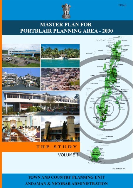
PB Master Plan Volume I.pdf - India Environment Portal
PB Master Plan Volume I.pdf - India Environment Portal
PB Master Plan Volume I.pdf - India Environment Portal

You also want an ePaper? Increase the reach of your titles
YUMPU automatically turns print PDFs into web optimized ePapers that Google loves.
MASTER PLAN FOR<br />
PORT BLAIR PLANNING AREA – 2030<br />
Final Report<br />
December 2011<br />
VOLUME I<br />
THE STUDY<br />
Town and Country <strong>Plan</strong>ning Unit<br />
Andaman & Nicobar Administration
FOREWORD<br />
Emerald islands more popularly known as Andaman and Nicobar Islands on the eastern side of <strong>India</strong> has a<br />
history dating back to 2nd century A.D., as a land of primitive tribes. These Islands played a major role<br />
during the colonial periods of <strong>India</strong>n history. What started as a penal settlement before <strong>India</strong>’s<br />
independence, these islands witnessed urbanization with tribes, islanders, patriots and settlers from the<br />
mainland. The earliest and fastest growing settlement in these islands PORT BLAIR, named after the<br />
British Colonel, serves as the catalyst for the growth of the islands. Port Blair with a population of 99,984<br />
(as of 2001) and extending over an area of 17.74 sq.km exhibit signs of haphazard development along with<br />
problems of urbanization. The emergence of Port Blair and the surrounding islands as a tourist spot,<br />
coupled with all issues and challenges of the ecologically fragile environment throws many challenges for<br />
future development.<br />
Several planning efforts had been undertaken in the past in guiding the future development. The Outline<br />
Development <strong>Plan</strong> for Port Blair prepared by the Town and Country <strong>Plan</strong>ning Organisation, New Delhi in<br />
1991, State Development Report prepared by National Institute of Public Finance and Policy in 2004,<br />
Andaman Islands Coastal Area Assessment Report by Equations, Ecological Sensitive Architecture Report<br />
by Expert Committee constituted by Ministry of Urban Development, Government of <strong>India</strong>, and<br />
Sustainable Development of Tsunami Affected Areas Report by School of <strong>Plan</strong>ning and Architecture,<br />
New Delhi have all studied the problems and potentials of the ANI and Port Blair. They have brought out<br />
the issues confronting the development and have suggested several recommendations.<br />
Realizing the complexity and interrelationships of the issues concerning development, and the need to<br />
have an integrated approach towards sustainable urban development, the Town and Country <strong>Plan</strong>ning Unit<br />
of the Andaman Public Works Department (APWD) has taken the lead in preparation of a <strong>Master</strong> <strong>Plan</strong> for<br />
Port Blair and its environs under Section 6, Chapter III of the Andaman and Nicobar Islands Town and<br />
Country <strong>Plan</strong>ning Regulations, 1994. The School of Architecture and <strong>Plan</strong>ning, Anna University, Chennai<br />
was entrusted with the task late in the year 2006.<br />
To evolve a most appropriate physical development strategy with the aim of developing Port Blair and its<br />
environs into a self sustaining entity, the consultancy team studied the development issues, their causes<br />
and consequences. The conceptual proposals were presented to the Coordination (Integration) Committee<br />
and the Advisory Council during May 2007, which were widely accepted. Thereafter, detailed field<br />
investigations were carried out and sectoral analysis were made in order to detail the conceptual proposals.<br />
To translate these into realities, an effective zoning and land use plan is conceived with appropriate<br />
development regulation. The draft <strong>Master</strong> <strong>Plan</strong> incorporating these features was thus prepared and<br />
presented to the Coordination (Integration) Committee and the Advisory Council in April 2008. The<br />
suggestions of the committee have been incorporated and the draft plan was notified in May 2009 for<br />
inviting objections and suggestions from any person and any institution including the local authorities. It<br />
was notified as per section 7 (1) and (2) of the Andaman and Nicobar Islands Town and Country <strong>Plan</strong>ning<br />
Regulation, 1994. Towards creating awareness among the people of Port Blair an Open House meeting<br />
was held in July 2009 and positive suggestions were received. The draft <strong>Master</strong> <strong>Plan</strong> was also presented to<br />
His Excellency the Lt. Governor. The Chief Secretary chaired the discussion meetings held in connection<br />
with the review of various comments received from the individuals/institutions and also the meeting held<br />
to review the follow up action taken. Appropriate decisions were taken in every meeting and this final<br />
report incorporates these decisions.<br />
It is hoped that the proposals envisaged as part of this final report which is presented in two volumes<br />
(volume I containing the study part and the volume II containing the development proposals) would meet<br />
the aspirations of the people and enable Port Blair to achieve sustainable growth taking into account, the<br />
fragile ecology of the region.
FOREWORD<br />
CHAPTER NO. TITLE<br />
CONTENTS<br />
VOLUME I – THE STUDY<br />
i<br />
PAGE NO.<br />
1. THE PAST & THE PRESENT 1<br />
2. DEVELOPMENT ISSUES AND PROSPECTS 39<br />
VOLUME II – DEVELOPMENT PROPOSALS
LIST OF TABLES<br />
TABLE NO. TITLE PAGE NO.<br />
Table No. 1.2.1<br />
ANI - Administrative Districts, District Head Quarters &<br />
Tehsils<br />
Table No. 1.4.2 Growth of Population - Port Blair 7<br />
Table No. 1.4.3 Population, Sex Distribution and Density in Port Blair 8<br />
Table No. 1.4.6 Changing Sex Ratio in Port Blair 9<br />
Table No. 1.5.3 Distribution of Working and Non-Working Population-2001 11<br />
Table No. 1.8.1 Port Blair - Sources of Water Supply 14<br />
Table No. 1.9.1 Higher Education Facilities in Port Blair 16<br />
Table No. 1.9.4 (a) Vital Statistics – South Andaman (2005) 17<br />
Table No. 1.9.4 (b) Health Institutions – South Andaman (2005) 17<br />
Table No. 1.9.4 (c) Manpower in Health Sector – South Andaman (2005) 17<br />
Table No. 1.10.4 (a) Tourist Accommodation Facilities-2004 20<br />
Table No. 1.10.4 (b) Domestic and International tourist arrival 21<br />
Table No. 1.12.3 Land Use Distribution: 2010 - Port Blair 25<br />
Table No: 1.13.3 Key Programmes of XI <strong>Plan</strong> – Port Blair 27<br />
ii<br />
4
LIST OF MAPS<br />
MAP NO. TITLE PAGE NO.<br />
Map No. 1 Location of Andaman Islands 29<br />
Map No. 2 Location of Port Blair 31<br />
Map No. 3 P B P A - Transportation Network 2010 33<br />
Map No. 4 P B P A – Water Sources 35<br />
Map No. 5 Port Blair – Existing Land use – 2010 37<br />
Map No. 6 Location of Slums in Port Blair 51<br />
LIST OF FIGURES<br />
FIGURE NO. TITLE PAGE NO.<br />
Figure No. 1.4.5 Ward wise net population density 9<br />
Figure No.1.5.1 Ward wise Literacy Profile 10<br />
Figure No. 1.6.5 Ward wise Distribution of Residential Areas 12<br />
Figure No. 1.6.6 Ward wise Distribution of Commercial Areas 13<br />
Figure No. 1.10.4<br />
Trends of Monthly Seasonal Variation in Tourist<br />
Arrival- 2004<br />
Figure No. 1.11.9 (a) Vehicular Status from 1990-2010 24<br />
Figure No. 1.11.9 (b) Vehicles Registration by Type upto 2010 24<br />
iii<br />
20
ABBREVIATIONS<br />
AMD -- Andaman Marine Drive<br />
ANI -- Andaman and Nicobar Islands<br />
APWD -- Andaman Public Works Department<br />
ATR -- Andaman Trunk Road<br />
BOD -- Biological Oxygen Demand<br />
BSNL -- Bharat Sanchar Nigam Limited<br />
C -- Commercial<br />
CAA -- Constitutional Amendment Acts<br />
CBA -- Continuous Building Area<br />
CMZ -- Coastal Management Zoning<br />
CRZ -- Coastal Regulation Zone<br />
D -- Defence<br />
DDMA -- District Disaster Management Authority<br />
DTCP -- Department of Town and Country <strong>Plan</strong>ning<br />
ECCE -- Early Childhood Care and Education<br />
EIL -- Engineers <strong>India</strong> Limited<br />
EWS -- Economically Weaker Section<br />
FAR -- Floor Area Ratio<br />
FAST -- Foundation for Aviation and Sustainable Tourism<br />
GDI -- Gender Disparity Index<br />
HDI -- Human Development Index<br />
HPI -- Human Poverty Index<br />
iv
HTL -- High Tide Line<br />
I -- Industrial<br />
ICRZ -- Island Coastal Regulation Zone<br />
ICS -- <strong>India</strong>n Civil Service<br />
IED -- Integrated Education for Disabled<br />
IPZ -- Island Protection Zone<br />
JNNURM -- Jawaharlal Nehru National Urban Renewal Mission<br />
MES -- Military Engineering Services<br />
MR -- Mixed Residential<br />
NDMA -- National Disaster Management Authority<br />
NEERI -- National <strong>Environment</strong>al Engineering and Research Institute<br />
NIOT -- National Institute of Ocean Technology<br />
ODP -- Outline Development <strong>Plan</strong><br />
<strong>PB</strong>PA -- Port Blair <strong>Plan</strong>ning Area<br />
<strong>PB</strong>PDA -- Port Blair <strong>Plan</strong>ning and Development Authority<br />
<strong>PB</strong>MC -- Port Blair Municipal Council<br />
POS -- Parks and Open Spaces<br />
PPH -- Persons per Hectare<br />
PR -- Primary Residential<br />
PSP -- Public and Semi Public<br />
SL -- Submergible Lands<br />
SPA -- School of <strong>Plan</strong>ning and Architecture, Delhi<br />
SR -- Special Reservation<br />
v
SWOT -- Strength, Weakness, Opportunities and Threats<br />
TC -- Transportation and Communication<br />
UDPFI -- Urban Development <strong>Plan</strong> Formulation & Implementation<br />
UNDP -- United Nations Development Programme<br />
UT -- Union Territory<br />
UTDMA -- Union Territory Disaster Management Authority<br />
WAPCOS -- Water and Power Consultancy Services (<strong>India</strong>) Limited<br />
WTD -- World Tourism Development<br />
vi
vii
<strong>Master</strong> <strong>Plan</strong> for Port Blair <strong>Plan</strong>ning Area The Past & The Present<br />
1<br />
THE PAST & THE PRESENT<br />
1.1 EVOLUTION OF SETTLEMENT 3<br />
1.2 ADMINISTRATION AND GOVERNANCE 4<br />
1.3 PHYSICAL FEATURES AND CLIMATE 5<br />
1.4 DEMOGRAPHIC CHARACTERISTICS 7<br />
1.5 SOCIO-CULTURAL FACTORS AND ECONOMIC STRUCTURE 9<br />
1.6 SHELTER AND BUILT ENVIRONMENT 11<br />
1.7 TRAFFIC AND TRANSPORTATION 13<br />
1.8 PHYSICAL INFRASTRUCTURE 14<br />
1.9 SOCIAL INFRASTRUCTURE 16<br />
1.10 RECREATION AND TOURISM 18<br />
1.11 ENVIRONMENT 21<br />
1.12 LAND USE AND OWNERSHIP 24<br />
1.13 DEVELOPMENT MEASURES 25<br />
1
<strong>Master</strong> <strong>Plan</strong> for Port Blair <strong>Plan</strong>ning Area The Past & The Present<br />
2
<strong>Master</strong> <strong>Plan</strong> for Port Blair <strong>Plan</strong>ning Area The Past & The Present<br />
THE PAST & THE PRESENT<br />
1.1 EVOLUTION OF SETTLEMENT<br />
1.1.1 Bay Islands more popularly known as Andaman and Nicobar Islands (ANI) are the large<br />
land forms though there are lesser known Islands and Islets named after persons who spotted them,<br />
visited them, managed them or colonized them. The primitive inhabitants of the Andaman and<br />
Nicobar Islands have been partly nomadic and lived by hunting and fishing. Anthropological<br />
studies reveal there are four Negrito tribes viz., the Great Andamanese, the Onges, the<br />
Jarawas and the Sentinelese, in Andaman group of Islands and the Nicobarese and Shompen, the<br />
two Mangoloid tribes in the Nicobar group of Islands. There are reports of the Chinese and the<br />
Malay pirates visiting these Islands in their canoes to capture these natives for their slave trade.<br />
Yet the Aboriginals undisputedly occupied these Islands for countless generations, though several<br />
people from outside attempted to colonise these Islands.<br />
1.1.2 The history of the Islands could be broadly divided into the following distinct periods;<br />
i) 2nd Century A.D to 16th Century AD : Stray incidents of Warfare, Slavery, bonded labour<br />
and looting ii) 1789 A.D : Establishment of settlement at Port Blair iii) 1792 A.D to 1796 A.D :<br />
Shifting of the settlements to North and its closure iv) 1796 A.D to 1858 A.D : Incidents of shipwrecks<br />
v) 1858 A.D : Setting up of the penal settlement at Port Blair vi) 1932 A.D to 1940 A.D :<br />
Japanese occupation of these Islands and advent of Netaji Subash Chandra Bose vii) 1941 A.D :<br />
Earthquake in the Ross Island, which made the Japanese to flee from the Islands, and viii) Since<br />
1947 A.D : Post Independence period with developmental activities.<br />
1.1.3 Vinayak Damodar Savarkar, great <strong>India</strong>n freedom fighter opined that the name Andaman<br />
is derived because of their egg shaped appearance (Anda means egg in most <strong>India</strong>n languages).<br />
Some historians say that the name Andaman relate to the Ramayana hero Hanuman while some<br />
pirates thought that Hanuman came from these Islands, which in course of time became Andaman.<br />
The East <strong>India</strong> Company planted its roots in the mainland and felt the necessity of a safe harbour<br />
on the east of Coramandel Coast. Lord Cornwallis, the then Governor General of the East<br />
<strong>India</strong> Company, commissioned Lieutenant Archibald Blair in December 1785 who sighted Port<br />
Cornwallis, now called as Port Blair. In 1789, it was decided to develop the settlements in the<br />
Andaman Islands, thus the regions surrounding Port Blair started developing.<br />
1.1.4 With the end of British Raj in <strong>India</strong> in 1947, these Islands became an integral part of<br />
<strong>India</strong>. Even before <strong>India</strong> could obtain full Independence the last British Chief Commissioner W.K.<br />
Patterson had handed over charge to Inam-ul-Majid, an <strong>India</strong>n officer of the <strong>India</strong>n Civil<br />
Service (ICS), who is credited for having launched the co-operative movement. The cooperative<br />
societies or the Panay-Hanay for the local people is a great social move. A.K. Gosh of<br />
the <strong>India</strong>n Civil Service, who succeeded formed an Advisory council for himself. He<br />
rehabilitated 2000 Bengali refugees, strengthened the Bush police and successfully conducted<br />
an expedition to have contact with Shompen, a hostile tribal group. Realizing the low sex ratio<br />
3
<strong>Master</strong> <strong>Plan</strong> for Port Blair <strong>Plan</strong>ning Area The Past & The Present<br />
in the Island, he encouraged mixed marriages, resulting in the development of a very<br />
heterogeneous society.<br />
1.1.5 A.K. Gosh was replaced by S.N. Moitra another ICS Officer, who could be the first person to<br />
have concentrated on the physical development of Port-Blair. Besides beautifying the City of Port<br />
Blair, he was responsible for carrying out the projects started in the First Five Year <strong>Plan</strong>. He<br />
constructed roads, introduced inter-island ship traffic, inaugurated the first bus service and also<br />
introduced mobile health services to different inhabited islands with a “Ship Hospital”. He planned<br />
the visit of Dr. Rajendra Prasad, the first President of Republic <strong>India</strong>. He brought Port Blair and the<br />
Island on the wheels of a major socio-economic reform making the Island an inseparable part of<br />
<strong>India</strong>n union.<br />
1.1.6 The erstwhile Municipal Board Regulations for Port Blair came into effect on 18 th June<br />
1957. The opening up of Air-Traffic between Calcutta and Port-Blair in 1963 and the starting of<br />
the All <strong>India</strong> Radio Station, in the same year are remarkable achievements. Under the State Re-<br />
Organization <strong>Plan</strong>, the Andaman and Nicobar Island was accorded the status of a Union Territory,<br />
with effect from 1 st November, 1966.<br />
1.2 ADMINISTRATION AND GOVERNANCE<br />
1.2.1 The Union Territory of Andaman and Nicobar Islands, after <strong>India</strong>’s political freedom,<br />
was awarded the status of Part-D State. For administration purposes the Union Territory has<br />
been divided into three Districts i.e. the Districts of South Andaman, North & Middle Andaman<br />
and the District of Nicobar. Andaman Islands have been divided into five tehsils and Nicobar into<br />
two tehsils. The sub division of the Islands and the tehsils under each of them are indicated in<br />
Table 1.2.1.<br />
Table No. 1.2.1 ANI - Administrative Districts, District Head Quarters & Tehsils<br />
DISTRICT<br />
North & Middle Andaman<br />
DISTRICT HEAD<br />
QUARTERS<br />
Mayabunder<br />
South Andaman Port Blair<br />
Nicobar Car Nicobar<br />
TEHSILS AREA (IN SQ.KM)<br />
Diglipur 884<br />
Mayabunder 1348<br />
Rangat 1070<br />
Port Blair 2021<br />
Ferrargunj 1085<br />
Car Nicobar 129<br />
Nancowry 1824<br />
4
<strong>Master</strong> <strong>Plan</strong> for Port Blair <strong>Plan</strong>ning Area The Past & The Present<br />
1.2.2 The Union Territory is a separate parliamentary constituency and there exists a three tier<br />
Panchayat Raj system to look after developmental activities and assist in the administration.<br />
Accordingly there are 67 Gram Panchayats, 7 Panchayat Samities and 2 Zilla Parisheds which<br />
function form the Panchayat Raj Systems in the Islands. The Lieutenant Governor is the<br />
Administrator of the Union Territory. There are nine Community Development Blocks in the<br />
Andaman and Nicobar Islands. Port Blair is the only major urban settlement. The Port Blair<br />
Municipal Area has been divided into eighteen wards for administrative purposes. There are<br />
eighteen elected councilors inclusive of Chairman, Senior Vice- Chairman and Junior Vice-<br />
Chairman (on rotational basis) and three nominated members.<br />
1.3 PHYSICAL FEATURES AND CLIMATE<br />
1.3.1 The Andaman and Nicobar Islands is the group of 572 Islands / Islets, of which only 37<br />
are inhabited. The Andaman and Nicobar groups of Islands are separated by the Ten Degree<br />
Channel. These Islands are bounded by the 10 0 N and 14 0 N latitudes as well as 92 0 E and 95 0 E<br />
longitudes. The North Andaman, the Middle Andaman, the South Andaman and the little Andaman<br />
are the major significant Islands of the group. The Andaman Islands stretches approximately for<br />
464 km. in length between North and South with an average width of 24 km. in the East - West<br />
direction. Map No. 1 and 2 indicate the location of Island with reference to mainland and Port Blair<br />
in Andaman and Nicobar Islands respectively.<br />
1.3.2 Andaman and Nicobar Islands of the Bay of Bengal is situated between Irrawaddy Head in<br />
Burma and the Achin Head of Sumatra. Significantly these Islands lie on the borders of the<br />
Eurasian Plate and Indo-Australian Plate which of late have shown signs of movement. These<br />
Islands also lie within the seismic zone of South East Asia (Earthquake belt) and they have been<br />
experiencing earth tremors at frequent intervals. As per the Meteorological Department these<br />
Islands are covered under Zone V, which are seismically most active region where earthquakes<br />
of magnitude 8 or more could occur. The earthquakes that occurred on 31st December 1881<br />
followed by another one in 1941 are the worst in the history. The TSUNAMI that struck the<br />
Island in December 2004 left a major scar in the history of the Island.<br />
1.3.3 Geologically the Islands are composed of thick Eocene deposits, sediment on Pre-Tertiary<br />
Sandstones, Shale's and Lime Stones. In these, sedimentary rocks have intruded basic and ultra<br />
basic rocks. Calcareous sandstones and sand rocks occur frequently interspersed with Intercalate<br />
clays and conglomerates. The intercalated clays are susceptible for erosion and give birth to serrated<br />
ridges in this region. Soils are original on the hill tops and ranges whereas along the sea-coast and<br />
valleys transported soils are found. The sandy soil along the coast consists of Shingles and Corals.<br />
Lower slopes of valleys have Clayey Loams. The soils vary from heavy clays to clay-loams,<br />
gravely loams, and sandy loams. These soils have low moisture retention capacity. Humus, an<br />
organic matter is lacking even in forest areas. With regard to minerals the surveys so far conducted<br />
reveals that the region has no deposits.<br />
5
<strong>Master</strong> <strong>Plan</strong> for Port Blair <strong>Plan</strong>ning Area The Past & The Present<br />
1.3.4 Andaman Islands in general and Port Blair in particular is located south of Tropic of Cancer<br />
and the region is surrounded by warm seas. The climate of this region is classified as Warm and<br />
Humid. The average temperature is in the range of 25 0 C to 30.5 0 C. The high temperature along<br />
with high relative humidity gives rise to high perceptible temperature and sultry weather. But<br />
this type of weather is tempered with pleasant sea breezes. Relative humidity is high throughout the<br />
year reaching > 90 % during the North West monsoons. The maximum temperature recorded at Port<br />
Blair is 32 0 C. The average annual rainfall is around 300 to 350 cm. Rainfall is received both from<br />
the South- West and North-East monsoon. May to August is the rainiest months and April is the<br />
warmest month is this region. It is observed that it is only the South-West monsoon that brings in<br />
most of the rainfall. During May-June, onset of the monsoon and in September- October withdrawal<br />
of monsoon is observed. The North East monsoons beginning in November continue till the end of<br />
February. March is observed to be the driest of the months. This transitional period is nonetheless<br />
disturbed by cyclonic storms which may be accompanied by thunder showers. Most of the storms<br />
experienced by the mainland and this region around Port Blair originate in Bay of Bengal.<br />
Occasionally storms originating in China Sea reach these parts of the Islands and have some impact.<br />
1.3.5 The water drains out rapidly because of steep slopes and sandy as well as loamy soils.<br />
Resultantly fresh water supply is scarce. South Andaman particularly has Ghats on the east and west.<br />
During dry season the streams either do not have any water or only a trickle of water. However, the<br />
streams in the South Andaman where Port Blair is located are somewhat perennial because of<br />
continuous and heavy rainfall.<br />
1.3.6 With an average temperature of 28 0 C and an exceptionally high rainfall around 350 cm. and<br />
active monsoon disturbances, these Islands are naturally covered with evergreen forests. The<br />
evergreen forests cover nearly 82 % of the total areas of these Islands excluding urbanized<br />
areas like Port Blair, Diglipur and Mayabunder. Along the coasts, vegetation is of mangrove type.<br />
Along the valleys typical tropical evergreen forests are present with scrub forests on the summits.<br />
Hardwood, Cane wood, Plywood, Matchwood, Cane and Resins are valuable gifts of Andaman<br />
forests with occasional occurrence of Glades and Bamboos. Andaman is called as “gold mine of<br />
timber”. Padak, Kukku, Chulgam, Marble wood, Satin wood, Pyinma, Bombway, Choei,<br />
Lalchim, Pongyet, Thitmin, Mouha, Khaya, Gangraw, Didu and Gurjan are some of the principal<br />
timber wealth in the forests of Andaman. Padak is the best known timber for its variety of colours<br />
and grains and is not found anywhere in <strong>India</strong>. The fauna and the animal life in South Andaman<br />
include Elephants, King Cobra, <strong>India</strong>n Cobra, Black Woodpecker, Lion Tailed Monkeys, Water<br />
Lizard, Estuarian Crocodile, Green Sea Turtle and Andaman Island Snake to mention a few.<br />
1.3.7 The Town of Port Blair, the administrative head quarters of the Union Territory of the<br />
Andaman and Nicobar Islands, is situated at the South East Coast of South Andaman at a distance<br />
of 1248 km. from Kolkata, and 1184 km. from Chennai. Port Blair, is characterized by undulating<br />
and rolling topography compared to relatively large valleys as seen in Diglipur and Betapur<br />
region in the north.<br />
6
<strong>Master</strong> <strong>Plan</strong> for Port Blair <strong>Plan</strong>ning Area The Past & The Present<br />
1.4 DEMOGRAPHIC CHARACTERISTICS<br />
1.4.1 Andaman Islands remained abode of Aborigines, and the Negritoes in seclusion, until the<br />
16th century. At the end of the 18th century and with the formation of penal settlement in 1858<br />
there began an influx of people, mainly from different parts of the <strong>India</strong>n mainland, East<br />
Pakistan (Bangladesh) and Burma (Myanmar). After independence refugees from East<br />
Bengal and South <strong>India</strong> started settling here. From planning and demographic point of view the<br />
people can broadly be classified as: 1) The Aboriginal Population, 2) the Refugees, 3) the Early<br />
Settlers and 4) the New Settlers. These people in the Island and Port Blair indicate the complex<br />
culture of this society.<br />
1.4.2 The population at Port Blair is steadily increasing. In 1961, the population at Port Blair<br />
was 14075. The population has shown nearly seven times increase during the period 1961-2001.<br />
As per the 2001 census, the population of Port Blair Town was 99984. During 1961-71 and 1971-<br />
81, Port Blair recorded a very high growth rate of 86 and 89 per cent respectively. Since 1981 the<br />
growth rates have notably come down. The growth rate of 51 per cent recorded in the year 1981-<br />
91 further came down to 33 per cent during 1991-2001. The declining growth rates could be<br />
attributed to out-migration outside Port Blair to surrounding regions and to mainland owing to the<br />
public policies that prevailed in the Islands and limitation of the Island in terms of its connectivity<br />
to the mainland. The detail of population and the growth of population at Port Blair is shown in<br />
Table 1.4.2.<br />
Table No. 1.4.2 Growth of Population - Port Blair<br />
Sl.No. Year Population Decadal Growth<br />
(%)<br />
1 1961 14075 --<br />
2 1971 26218 86.27<br />
3 1981 49634 89.31<br />
4 1991 74995 51.10<br />
5 2001 99984 33.32<br />
Source: Census of <strong>India</strong>.<br />
1.4.3. The gross density of the Andaman and Nicobar Islands has increased from 4 persons per<br />
sq.km., to 43 persons per sq.km., during the period 1951-2001. However, it is still substantially<br />
lower than the National figure of 324 persons per sq.km. The gross density at Port Blair Town<br />
was 5636 persons per sq.km., in the year 2001. A comparative statement of ward wise distribution<br />
of population in 1991 and 2001 at Port Blair is shown in Table 1.4.3.<br />
7
<strong>Master</strong> <strong>Plan</strong> for Port Blair <strong>Plan</strong>ning Area The Past & The Present<br />
WARD<br />
NUMBER<br />
Table No. 1.4.3 Population, Sex Distribution and Density in Port Blair<br />
POPULATION - 1991 POPULATION - 2001<br />
GROSS<br />
DENSITY<br />
MALE FEMALE TOTAL MALE FEMALE TOTAL<br />
(PPH)<br />
2001<br />
1 4701 3812 8513 2926 2445 5371 103<br />
2 2763 1942 4705 4890 3367 8257 258<br />
3 3635 2890 6525 3482 2933 6415 50<br />
4 5336 4364 9700 3811 3324 7135 125<br />
5 3564 2757 6321 2533 2129 4662 72<br />
6 958 629 1587 2433 2038 4471 60<br />
7 1824 1115 2939 3278 2727 6005 200<br />
8 3715 3041 6756 2656 2285 4941 137<br />
9 6672 4783 11455 2984 2564 5548 97<br />
10 1791 1325 3116 5185 4232 9417 59<br />
11 7424 5914 13338 2856 2339 5195 22<br />
12 --- --- --- 2613 2117 4730 75<br />
13 --- --- --- 2342 1820 4162 149<br />
14 --- --- --- 2693 1997 4690 66<br />
15 --- --- --- 1953 1700 3653 34<br />
16 --- --- --- 2435 1724 4159 88<br />
17 --- --- --- 3444 2680 6124 24<br />
18 --- --- --- 2859 2190 5049 19<br />
Total 42383 32572 74955 55373 44611 99984 56<br />
Source: Sustainable Development of Tsunami Affected Areas, Report by SPA, New Delhi<br />
1.4.4. The distribution of population at ward level indicates that the population is highest at the<br />
northern portion of the Town in areas like Aberdeen, Haddo, which constitute the oldest parts of<br />
the Town. After 2001, it is observed that parts of south adjoining Garacharma, Brichgunj and<br />
Dollygunj show higher densities. The gross density pattern of wards range between 258 persons<br />
per hectare (PPH) (ward no: 2) to as low as 19 PPH in outlying areas (ward no.18) and it is also<br />
seen from the Table 1.4.3, that more than 12 of the 18 wards register less than 100 PPH.<br />
Variations in density can be attributed to the fact that in many of the wards sizable extent of lands<br />
are under defence or unsuitable for development.<br />
1.4.5 The net density pattern which includes residential areas alone again varies like gross<br />
density. In most of the wards it is seen that gross density is directly correlated to the net density,<br />
except in ward no.9, where nearly two third of the ward area is observed to be under defence lands<br />
and the net density is as high as 1109 PPH. Out of the remaining 17 wards except for five wards i.e.<br />
3, 11, 15, 17, and 18 all others have already reached a net density of 200 PPH. Even these five<br />
wards indicate that they comprise of agriculture and forest lands. Analysis reveals that densities are<br />
high and seen growing along the major roads in the same direction of urban expansion in south<br />
8
<strong>Master</strong> <strong>Plan</strong> for Port Blair <strong>Plan</strong>ning Area The Past & The Present<br />
towards Garacharma, Dollygunj areas. Secondly, it is also observed that non-availability of land for<br />
development poses constraint for future development of the Town. Figure 1.4.5 shows the net<br />
population density in Port Blair.<br />
Figure No. 1.4.5 Ward wise Net Population Density<br />
Source: Sustainable Development of Tsunami Affected Areas, Report by SPA, New Delhi<br />
1.4.6 Sex ratio of Andaman Islands is reported to be 846 which is low compared to the National<br />
average of 933. The Port Blair Municipal Area has recorded a sex ratio of 806 in the year 2001. The<br />
sex ratio is gradually increasing from 1971 upto 2001 in the Municipal Area of Port Blair.<br />
Government employees who have come and settled with their families have been responsible for a<br />
gradual increase in sex ratio over the time as indicated in Table 1.4.6.<br />
Table No. 1.4.6 Changing Sex Ratio in Port Blair<br />
YEAR 1971 1981 1991 2001<br />
SEX RATIO 560 708 781 806<br />
Source: Census of <strong>India</strong><br />
1.5 SOCIO-CULTURAL FACTORS AND ECONOMIC STRUCTURE<br />
1.5.1 Since independence major changes have occurred with the continuous implementation of<br />
Five Year <strong>Plan</strong>s by the Government of <strong>India</strong>. With the thrust on social and tribal welfare<br />
programmes, the community has become more literate and economic generation through<br />
specific occupations to support modern way of life is noticed. In today’s context Port Blair<br />
Town accounts for high literacy rate compared to the Union Territory’s level. The literacy rate of<br />
Port Blair has increased from 69% in 1991 to 77% in 2001. As per census 2001, 81% of the males<br />
are literate while female literacy rate stands at 72%. Port Blair Town and surrounding region<br />
indicate high literacy rate because of its administrative importance and accounts for large number<br />
9
<strong>Master</strong> <strong>Plan</strong> for Port Blair <strong>Plan</strong>ning Area The Past & The Present<br />
of government employees. In Port Blair, wards numbers 6, and 11 to 16 accounts for highest<br />
literate population of more than 80% compared to other wards. The ward wise literacy profile is<br />
shown in Figure 1.5.1.<br />
Source: Census of <strong>India</strong><br />
Figure No. 1.5.1 Ward wise Literacy Profile - 2001<br />
1.5.2 Socio culturally, the population of Port Blair and the surrounding regions presents a<br />
heterogeneous mix. The Hindus dominate with 64% followed by Christians 24%, Muslims 8%,<br />
and the rest from other religions. People from all parts of the mainland are seen here and hence<br />
Port Blair is generally known as miniature <strong>India</strong>. Leaving the six dialects of the Nicobarese, as on<br />
date there are about thirty language groups amongst the population of Port Blair. The main groups<br />
are Hindi, Bengali, Malayalam, Tamil, Telugu and Nicobarese.<br />
1.5.3 Occupational structure of Port Blair and the surrounding regions reveals that in the<br />
beginning, economy of the Island was mainly dependent on agriculture, fishing and timber based<br />
small scale industries. In Port Blair, 60% of the workforce is employed in the tertiary sector and<br />
most of them are placed in the government sector. Agriculture in the Island and specifically South<br />
Andaman is dependent entirely on rainfall and the extent of irrigation is limited. The State<br />
Development Report for Andaman and Nicobar Islands, 2006 suggests that there is scope for<br />
growing medicinal plant, cultivation of spices and coconut, improvements in horticultural<br />
products and flora and fauna of ethnic communities. Early settlers have developed paddy farms in<br />
South Andaman. Other important crops are coconut, fruit, condiments and spices. Occupational<br />
structure of population as per 2001 census shows 63% as non- workers, 36% as main workers and<br />
1% as marginal workers. The State Development Report – 2006 indicates a declining trend of<br />
workers productivity. The output of per worker value has also decreased from 1996 to 2002.<br />
However, the per capita income of Rs. 15,703/- for the year 2001-02 in the ANI is higher than<br />
<strong>India</strong>’s figure of Rs.12,203/-. Similarly the minimum average wage rate in the Islands has<br />
increased from Rs.27/- during 1992-93 to Rs.100/- during 2002-03 and to Rs.162/- during 2005-<br />
2006. Table 1.5.3 provides the distribution of working and non-working population of Port Blair<br />
Town.<br />
10
<strong>Master</strong> <strong>Plan</strong> for Port Blair <strong>Plan</strong>ning Area The Past & The Present<br />
Table No. 1.5.3 Distribution of Working & Non Working Population - 2001<br />
CATEGORY MALE FEMALE TOTAL PERCENTAGE<br />
Main Workers 30,183 5,202 35,385 36<br />
Marginal Workers 1076 280 1,356 1<br />
Non – Workers 24,114 39,129 63,243 63<br />
Total Population<br />
Source: Census of <strong>India</strong><br />
55,373 44,611 99,984 100<br />
1.6 SHELTER AND BUILT ENVIRONMENT<br />
1.6.1 The Town of Port Blair as a symbol of urbanization is an amalgam of various land uses<br />
catering to the various expectations and aspirations of contemporary community. The total<br />
Municipal area is 17.74 sq. km. of which only 6.63 sq.km of land is under residential use.<br />
1.6.2 Unlike the towns on the main land <strong>India</strong>, where residential areas in a town occupy 45% to<br />
55% of total town area, in Port Blair the residential area occupies only 33 % of the Town area as<br />
of 2010. This phenomenon is due to the fact that 30% percentage of land is occupied by defence,<br />
forest, agriculture, water bodies, and intricate road network within the municipal limits. Some of<br />
the residential areas within municipal limits lack community recreational spaces and related civic<br />
amenities. There are no Theatres screening Movies at Port Blair, and viewing Cinema is restricted<br />
to Televisions. Recreational area occupies only 2 % of Town area which indicates the contended<br />
life style of the people. Public and semi public areas occupy 10 % of total Municipal Area with a<br />
concentration of government offices and institutions. Comparative analysis from 1981 to 2010<br />
indicates substantial growth under this zone. In the surrounding regions outside Port Blair,<br />
Bamboo flat on the North, Dollygunj, Austinabad and Garacharma on the South West account<br />
for large residential areas.<br />
1.6.3. The household survey conducted in the year 2007, reveals that majority of the households<br />
(78 %) at Port Blair are living in their own house. Only 9 % of the households are in rental houses<br />
and the remaining 13 % of the households are accommodated at Government quarters. However<br />
in surrounding regions of Port Blair, more than 25 % of households are residing at rented houses.<br />
Most of the people in the Town of Port Blair live in individual types of houses (81% ) indicating a<br />
preference to such form of development and less popularity of flats or apartments which<br />
constitute 3% of total housing. At the same time, apartments are emerging in the surrounding<br />
region which is of the order of 9%. The average plot size in Port Blair and environs is around 60<br />
sq.m with a built up area of 50 sq.m accounting for 73% of total residential accommodation. Even<br />
today the Town of Port Blair indicates a preference for single storied housing which constitutes<br />
84% of total housing and most of them remain as primary residential area.<br />
11
<strong>Master</strong> <strong>Plan</strong> for Port Blair <strong>Plan</strong>ning Area The Past & The Present<br />
1.6.4. Residential dwellings in Port Blair predominantly use celcrete or hollow blocks (55%) as<br />
filler material with RCC load bearing members followed by bricks (20%). It is observed that in<br />
the outlying areas around Port Blair hollow blocks manufacturing industries are existing and are<br />
coming up. Timber as a partition was used in some of the houses accounting for 15% of total<br />
housing. The most popular roofing material is galvanised iron sheets which accounts for 51%<br />
because of its lightness, easy transportation cost and quick erection possibilities. Around 21%<br />
housing, especially the government housing use reinforced cement concrete as roofing material.<br />
Continuous building as a typology is restricted to certain areas like Aberdeen, Delanipur, Haddo,<br />
Phoenix Bay and Dairy Farm Area accounting for 15% of total housing.<br />
1.6.5. Figure 1.6.5 indicates the ward wise distribution of residential areas in Port Blair. It is seen<br />
that Wards 3,4,10,11,17 and 18 consisting of areas in Haddo, Junglighat, Lambaline, Nayagoan,<br />
Dudhline and School Line account for large spread of residential areas.<br />
Figure No. 1.6.5 Ward wise Distribution of Residential Areas<br />
Source: Sustainable Development of Tsunami Affected Areas, Report by SPA, New Delhi<br />
1.6.6. Morphological evolution of the built environment in the Island and Port Blair in particular<br />
indicate an informal, organic growth with colonial histogenesis and sporadic developments of<br />
building activities continuously. Commercial requirements of the community and people<br />
indicate a sporadic distribution, organically developed to meet the demands of the people. Unlike<br />
the towns of the mainland where it is possible to discern a central business district in the oldest<br />
part of the town, Port Blair remains an exception. The only “possible” commercial hub i.e. the<br />
Aberdeen market in the central area of Town is characterized by mixed land uses, including<br />
residential areas. Linear, sporadic, discontinuous, strips of commercial activities are observed<br />
along most of the major roads. It is also observed that there is no distinct segregation of wholesale<br />
and retail activities. The existing commercial activities, shops and business premises have reached<br />
a stage giving little possibilities for expansion. Figure 1.6.6 gives an idea of ward-wise<br />
distribution of commercial areas in Port Blair.<br />
12
<strong>Master</strong> <strong>Plan</strong> for Port Blair <strong>Plan</strong>ning Area The Past & The Present<br />
Figure No. 1.6.6 Ward wise Distribution of Commercial Areas<br />
Source: Sustainable Development of Tsunami Affected Areas, Report by SPA, New Delhi<br />
1.6.7. From the Figure it is seen that ward no. 3 (Delanipur), ward no. 6, ward no. 12 (Aberdeen),<br />
ward no. 13 and 17 (Dudhline) have substantial areas (more than 4 Hectares) under commercial<br />
land use which are the oldest parts of the Town as well as outlying (presently developing) areas<br />
showing signs of development . It is also observed that linear strips of commercial areas in the<br />
frontage of prominent streets not only contain residential settlements behind them, which are<br />
invariably on slopes but also make the commerce and business premises easily seen and<br />
accessible. The low rate of commercial activities (2 % of total Town area) suggests the need for<br />
improvement.<br />
1.7 TRAFFIC AND TRANSPORTATION<br />
1.7.1 The principle modes of transportation within the Union Territory are roads and waterways.<br />
During 1982-83 the total road lengths in the Islands was 695 km., which increased to 733 km.<br />
during 1987-88 and to 850 km. at present. South Andaman, where Port Blair is situated accounts<br />
for 281 km. length and the Town has 65 km. within it. Apart from the land transport and vehicles,<br />
ships, boats, steamers, ferries are available for inter- island transportation. Air <strong>India</strong> and couple of<br />
private airline services link Port Blair with Chennai, and Kolkata.<br />
1.7.2 Within the Town of Port Blair, due to its organic growth, terrain and topography<br />
meandering road pattern is observed. The form and pattern resembles open order settlement and<br />
the roads are very steep (more than 1:10) and plain in certain regions. Map No. 3 shows the<br />
predominant road network in Port Blair. The plots and sites on steep slopes make accessibility<br />
difficult. Traffic congestion and bottlenecks are observed on several roads due to location of<br />
private and automobile workshops. Garages along road margins also reduce effective width of the<br />
roads. Most of the roads are subjected to encroachments and these roads have reached saturation<br />
point beyond their carrying capacity. The total area under roads is 140 hectares i.e. 8% of total<br />
area.<br />
13
<strong>Master</strong> <strong>Plan</strong> for Port Blair <strong>Plan</strong>ning Area The Past & The Present<br />
1.7.3 The existing air-port is a civil enclave and is with the Defence. It is located at the heart of<br />
the Town, surrounded by hills on both sides and has limited scope for expansion. It has a unidirectional<br />
run-way. During adverse weather condition, the run way gets inundated and results in<br />
disruption and delay of flights. However, recently it has been declared as an International Air Port<br />
by Government of <strong>India</strong>. The Air Passenger traffic has increased to 130% from November 2005<br />
to November 2006 for Port Blair. Air link is observed to be most popular between the Island and<br />
Mainland.<br />
1.8 PHYSICAL INFRASTRUCTURE<br />
1.8.1 At a macro level the islands have no major water sources. Even with urbanization of<br />
certain areas, in the absence of any perennial rivers or streams and with a saline and brackish<br />
ground water, treated and protected water supply becomes a challenge. The main source of water<br />
for drinking purpose and domestic consumption is through collection of rainwater in natural<br />
reservoirs and small check dams and wells. The main water sources for Port Blair within South<br />
Andaman are indicated in Table 1.8.1.<br />
Table No. 1.8.1 Port Blair - Sources of Water Supply<br />
SL.NO. NAME CAPACITY (MLD)<br />
1. Dilthaman Diggi 0.01<br />
2. Jawahar Sarovar 1.75<br />
3. Nayagoan Diggi & Chakkaragaon 0.45<br />
4. Dhanikhari Reservoir 16.86<br />
5. Other Sources 6.70<br />
Total 25.77<br />
1.8.2. The water supplied to Port Blair and its environs are treated at the four locations namely<br />
Lambaline, Dairy farm, Garacharma and Dilthaman tank. Treated water from these plants is<br />
distributed to various parts of the city and sub-urban areas, through pumping stations. The four<br />
main pumping stations are: (i) Police Hill pumping station, (ii) Buniyabad pumping station, (iii)<br />
A.I.R. pumping station and (iv) Dairy Farm pumping station. Map No. 4 shows the sources of<br />
water, location of treatment plants and pumping stations in the region of Port Blair. Water supply<br />
to the Town is provided by Port Blair Municipal Council (<strong>PB</strong>MC) and to the rest of the areas by<br />
the Andaman Public Works Department (APWD) mainly through piped network and Lorries. At<br />
present the total demand of water for Port Blair is estimated as 28.80 MLD, leaving a short fall of<br />
around 3.03 MLD. The water supply to the consumers is on alternate days only during monsoon<br />
and once in three days during summer. Water tariffs for domestic supply are heavily subsidized at<br />
the rate of Rs.18/- per month. Tariff for religious institutions are treated as domestic connection,<br />
while for commercial, establishments, institutions, Government Departments it varies.<br />
14
<strong>Master</strong> <strong>Plan</strong> for Port Blair <strong>Plan</strong>ning Area The Past & The Present<br />
1.8.3 Underground sewerage system is not available at present in Port Blair. Systems of<br />
individual and combined septic tanks are popularly in use at most areas of the Town. Since there<br />
are no separate sewer lines, the sewage joins the natural drainage system and is let out onto sea.<br />
1.8.4 Out of the total 18 wards in Port Blair, Mohanpura is considered to be most<br />
problematic because of low lying land involving intricate network of drains. These drains flow<br />
directly into Bay of Bengal at various outlets. The main drainage originates from Goal Ghar,<br />
following the existing terrain, falls at Phoenix Bay carrying all the discharge of the subsidiary<br />
drains on the eastern and western sides of the trunk road. The present Airport complex and<br />
surrounding areas also drain into Bay of Bengal. The outlet drains of Mohanpura are at Phoenix<br />
Bay and the Airport region near Corbyn’s Cove. Wards 6 and 8 have problem of drainage<br />
congestion and stagnation caused by clogging of drains. Garbage refuse in places like Haddo and<br />
commercial areas clog the drains at slopes which are gentle or relatively flat. The carrying<br />
capacity of most of the drains is much less than the average rainfall and hence the drains overflow<br />
and inundate adjoining areas leading to environmental hazards. Houses built on steep slopes have<br />
cut through the terrain for a flat base and thus reduce the natural flow of rain water.<br />
1.8.5 With the constitution of Port Blair Municipal Council in the year 1967, the responsibility of<br />
solid waste collection and disposal rests with it. The Municipal Council employs about 1150<br />
workers, who collect about 50 metric tonnes of garbage per day. Garbage is collected in Port Blair<br />
Town at 68 locations through door to door collection system. However segregation of garbage<br />
into degradable and non-degradable has not been fully achieved. The garbage is collected by 10<br />
garbage trucks (Hydraulic Tipper Trucks) and 2 Dumper Placer Trucks (with the facility of<br />
Mechanical placement). Each truck has a carrying capacity of 4 to 5 cubic meters and runs twice a<br />
day.<br />
1.8.6 Brookshabad is the place where segregation of garbage is done and plastic are disposed off<br />
through a plasma pyrolysis plant located there. Bio-medical waste segregation is given<br />
importance, by separating them at generation points. Waste disposal at Wharfs and Dock yards<br />
are not properly handled. Garbage thrown by tourists and dwellings on the coast into the sea are<br />
partly brought back to beaches on coastal stretches by the waves. Corbyn’s cove beach is a<br />
standing example. Garbage cans are collected by the tipper trucks. It is also ascertained that some<br />
of the stretches within the city do not have daily collection of garbage leading to spillage and<br />
causing environmental degradation. It is also observed that where door to door collection of<br />
garbage is not there, they are dumped on the nearby empty grounds in plots acting as breeding<br />
grounds for insects, flies and mosquitoes. Solid waste management in the Island and Port Blair in<br />
particular is not satisfactory and requires improvements.<br />
15
<strong>Master</strong> <strong>Plan</strong> for Port Blair <strong>Plan</strong>ning Area The Past & The Present<br />
1.9 SOCIAL INFRASTRUCTURE<br />
1.9.1 South Andaman including Port Blair can boast of 22 pre-primary, 54 primary, 24 middle,<br />
and 16 secondary and 24 senior secondary schools. In addition 1 industrial training institute, 2<br />
polytechnic, 1 teacher training institute, 1 B.Ed. College, 1 government arts college and 1<br />
Engineering college are located in Port Blair. Higher education facilities are available as indicated<br />
in the Table 1.9.1. Schools are spread throughout the Island and it is observed that there has been<br />
no substantial increase or expansion of this facility. Education is provided free in Andaman and<br />
Nicobar Islands. Free text books and uniforms to all tribal students, and to students of poor<br />
families are provided. Free travel concessions are also provided to students attending schools.<br />
The Teacher’s Training Institute at Port Blair provides two year instructions at undergraduate<br />
level to primary school teachers. Computer education is provided to girls under the social welfare<br />
scheme. The State library at Port Blair is well established with more than 83,000 volumes.<br />
SL. NO. FACILITY<br />
Table No. 1.9.1 Higher Education Facilities in Port Blair<br />
NO. OF<br />
INSTITUTION<br />
ENROLMENT OF<br />
STUDENTS<br />
TEACHING STAFF<br />
1. Industrial Training Institute 1 192 8<br />
2. Teachers Training Institute 1 123 17<br />
3. Teachers College (B.Ed.) 1 139 18<br />
4. Government Arts and Science College 1 2039 98<br />
5. Polytechnic 2 407 40<br />
6. Engineering College 1 78<br />
1.9.2 As far as Port Blair is concerned, compared to the region of South Andaman, though<br />
educational facilities are adequate in terms of number and quality, the distribution is not rational<br />
in terms of accessibility. The student-teacher ratio has improved to 19:1 in 2006. Concentration of<br />
prime and important educational institutions in Port Blair indicate that it is an important<br />
educational centre apart from being the administrative centre. Considering the fragile nature<br />
of environment in the Islands, school education policy may have to sensitize students on<br />
<strong>Environment</strong>al Education and Sustainable Development. Similarly, sensitization of the<br />
community and younger generation of students towards forest education, focusing on<br />
conservation, preservation and forest resources is required.<br />
1.9.3. The Island authorities have taken up lots of efforts in strengthening the education sector<br />
through several other schemes. Early Childhood Care and Education (ECCE.), Improvement in<br />
Academic Inputs, Community Participation, Science Education, Integrated Education for<br />
Disabled (IED), Adult Education, Sarva Shiksha Abhiyan, Computer Education, Enhancement<br />
of Merit Scholarships and Upliftment of Rural and Tribal Education are some of the schemes.<br />
1.9.4 Port Blair and environs witness the presence of health institutions from the highest level<br />
to the lowest level, with good strength of support staff. In spite of certain constraints, the<br />
16
<strong>Master</strong> <strong>Plan</strong> for Port Blair <strong>Plan</strong>ning Area The Past & The Present<br />
Union Territory present a very good picture of health facilities available. The following Tables<br />
1.9.4 (a), 1.9.4 (b), 1.9.4 (c) show the vital statistics, availability of health institutions and man<br />
power in health sector in South Andaman during the year 2005 respectively.<br />
Table No. 1.9.4 (a) Vital Statistics – South Andaman (2005)<br />
SL. NO. INDICATOR VALUE / 1000 PPL<br />
1. Birth Rate 17.81<br />
2. Death Rate 3.41<br />
3. Infant Mortality Rate 17.33<br />
4. Total Fertility Rate 1.9<br />
5. Institutional Delivery 88<br />
Source: Island wise Statistical Outline – 2005, Directorate of Economics & Statistics<br />
Table No. 1.9.4 (b) Health Institutions – South Andaman (2005)<br />
SL. NO.<br />
INSTITUTION NUMBER<br />
1. Hospital 1<br />
2. Community Health Centre 1<br />
3. Primary Health Centre 4<br />
4. Urban Health Centre 5<br />
5. Sub Centre 26<br />
6. Dispensary 2<br />
7. Total Bed Strength 565<br />
Source: Island wise Statistical Outline – 2005, Directorate of Economics & Statistics<br />
Table No: 1.9.4 (c) Manpower in Health Sector – South Andaman (2005)<br />
SL. NO. CATEGORY NUMBER<br />
1. Doctors 90<br />
2. Nurses / Midwives/LHVs 269<br />
3. Para Medical Staff 1002<br />
Source: Island wise Statistical Outline – 2005, Directorate of Economics & Statistics<br />
1.9.5 The 450 bedded General Hospital at Port Blair is the only referral hospital for the entire<br />
territory. This hospital has emergency treatment facilities for patients, ambulance services, and<br />
tele-consultation / online services. All the Primary Health Centres have a minimum of 10 beds<br />
each and Community Health Centres have a minimum of 50 beds and diagnostic facilities. The<br />
Sub Centres are located approximately within 5 Km. and Primary Health Centres within 10 km.<br />
distance. In addition, there are eight Homeopathy Dispensaries and one Ayurvedic Hospital in and<br />
around Port Blair. It is observed that modernization of equipments and increased staffs are<br />
required to improve health care. All health facilities are provided free of cost including<br />
17
<strong>Master</strong> <strong>Plan</strong> for Port Blair <strong>Plan</strong>ning Area The Past & The Present<br />
investigation, treatment, medicines and diet. The occurrence of AIDS and HIV +ve cases,<br />
cause concern requiring special attention. About 301 cases of HIV +ve have been detected till<br />
2006. With the declaration of Port Blair as an international airport the mainland and foreign<br />
tourist population are increasing. To cater to their needs a super specialty hospital is necessary.<br />
1.9.6 Health care facilities are comprehensive and adequate for the animals and live stock in the<br />
surrounding region of Port Blair. There are three Veterinary Hospitals, four Veterinary<br />
Dispensaries, seven Veterinary Sub-Dispensaries, one Veterinary Poly Clinic, two Disease<br />
Investigation Labs and one Artificial Insemination Centres and fifteen Sub Centres are available.<br />
Though most of these are concentrated in and around Port Blair, they greatly benefit the entire<br />
South Andaman Island.<br />
1.9.7 A broad list of community facilities discussed here for Port Blair surrounding region<br />
include Postal service, Telecommunication, Mass Media, Banking, Co-operatives and Social<br />
Welfare. There is one head post office at Middle point, and thirteen sub-post offices distributed in<br />
South Andaman. There are nineteen telephone exchanges with 29,442 telephone connections.<br />
There is one telegraph office. Around 187 public call offices are available in the South Andaman<br />
in addition to BSNL, Airtel, Vodofone, and Reliance provide mobile and broadband connectivity.<br />
As for Mass Communication is concerned there are two Doordarshan Transmission Centres and<br />
one Radio Transmission Centre in Port Blair.<br />
1.9.8 The Banking and Co-operative sectors are good and fairly distributed in South Andaman<br />
District. In addition, two All <strong>India</strong> financial institutions, eleven commercial banks, twenty three<br />
commercial bank branches and twelve co-operative bank branches are located in the District.<br />
1.9.9 In terms of social welfare facilities, South Andaman has five Balwadi centres, sixty one<br />
Crèche Centres and five Craft Centres. Womenfolk greatly benefit from these. South Andaman<br />
region has 265 Fair Price Shops regulated by the Civil Supplies Department, of which 10 cater to<br />
the Town’s requirement. Facilities that are concerned with law and order are adequate. South<br />
Andaman has six Police Stations, one Police Outpost, 7 Fire Stations to take care of Law and<br />
Safety of the people in the region. Community facilities such as Marriage Halls and Community<br />
Halls are adequate for the population.<br />
1.10 RECREATION AND TOURISM<br />
1.10.1 Andaman and Nicobar Islands are covered with dense evergreen forests with exotic flora<br />
and fauna, sandy beaches, meandering coastline, mangrove lined creeks, and unpolluted fresh air<br />
to produce a life time memorable experience. Town of Port Blair is strategically located in South<br />
Andaman and connected to other tourist spots with an international airport. Detailed<br />
analysis of tourism sector reveals that the ANI Islands have a potential in the future. Tourism is<br />
bound to generate employment, foreign exchange, and improve economy.<br />
18
<strong>Master</strong> <strong>Plan</strong> for Port Blair <strong>Plan</strong>ning Area The Past & The Present<br />
1.10.2 Some of the most important Tourism destinations in and around Port Blair include -<br />
• Cellular Jail: Located on the North East of Port Blair Town was completed in 1906 and is a<br />
National memorial. It derives its name for its individual cells for the solitary confinement<br />
of our freedom fighters and prisoners. The Government of <strong>India</strong> has taken efforts to<br />
maintain and landscape the entire campus which attracts lots of tourists.<br />
• Chatham Saw Mill: Located on the North of Port Blair in the Chatham Island which is the<br />
Asia’s largest Saw Mill. It is approached from Port Blair through a causeway over stretch<br />
of water.<br />
• Ross Island: It was the Original Capital during the British regime and this tiny Island (0.6<br />
sq. km. area) is 10 minutes journey from Port Blair. The Island houses reminiscent of bygone<br />
British era in extreme dilapidated condition, like the Ball Room, Chief Commissioner’s<br />
house, Government house, Church, Cemetery, Hospital, Bakery, Press, Swimming pool<br />
and Troop barracks.<br />
• Corbyn’s Cove: The coconut farmed beach is 7 km. from Port Blair. Tourist facilities like<br />
hotel, restaurant, bar, changing room are available near the beach. Historical Japanese<br />
bunkers can be seen here. Snake Island is nearby and it is recommended for scuba diving.<br />
• Viper Island: The first jail for freedom fighters of <strong>India</strong> was built by Britisher's here and<br />
was abandoned after building the cellular jail at Port Blair. In the gallous atop the hillock,<br />
Sher Ali, who killed Lord Mayo, Viceroy of <strong>India</strong> was hanged in the year 1872.<br />
1.10.3 In addition to these, Port Blair has a City Aquarium, Andaman Water Sports Complex,<br />
Light & Sound shows at Cellular Jail, Marine Museum, Zoological Survey of <strong>India</strong> Museum,<br />
Forest Museum, Anthropological Museum and Science Centre. Chidiyatapu, 25 KM by road from<br />
Port Blair on the southernmost tip of South Andaman houses the biological park. It is an ideal<br />
picnic spot for its sun-rise and sun-set. Sippighat, 14 km. by road from Port Blair, and Collinpur<br />
sandy beach 36 km. from Port Blair are suitable for swimming. Madhuban, 75 km. by road and 20<br />
km. by ferry from Port Blair is a suitable area for trekking. The Island authorities and Tourism<br />
department organizes Festivals, Cultural Shows, Shopping Mela, apart from package tours and<br />
conducted tours. The predominant season is observed to be December to March.<br />
1.10.4 Tourist accommodation facilities are available both from the government and private<br />
sector. The available facilities are listed in Table 1.10.4 (a). The average occupancy rate of<br />
organized accommodation has hardly reached 65%. The peak occupancy rate records 2667<br />
beds as against available 2837 beds (94%). Tourism has not reached its full potential in<br />
generation or acceleration of economy in the Island though it offers vast scope for<br />
development.<br />
19
<strong>Master</strong> <strong>Plan</strong> for Port Blair <strong>Plan</strong>ning Area The Past & The Present<br />
SL.<br />
NO.<br />
Table No: 1.10.4 (a) Tourist Accommodation Facilities-2004<br />
TYPE / CATEGORY<br />
1. Private hotels affiliated to State<br />
Tourism Department<br />
Government accommodation affiliated<br />
to State Tourism Department<br />
3. Budget accommodation affiliated to<br />
State Tourism Department<br />
NO. OF<br />
COMPLEXES<br />
AVAILABLE<br />
BEDS<br />
TARIFF<br />
RANGE IN<br />
RUPEES<br />
16 900 350-3650<br />
19 586 150-2000<br />
45 1351 150-900<br />
Total 80 2847<br />
Source: Sustainable Development of Tsunami affected areas – Report by SPA, Delhi.<br />
The monthly seasonal variation of tourist arrival in 2010 is shown in Figure 1.10.4. Generally<br />
December is the month attracting more number of tourists. During the month of December 2010<br />
alone, 27550 have visited these islands. The peak season for tourist arrival is October to<br />
December. About 37 % of the tourists visit these islands during this season. The tourist's arrival<br />
gradually decline from the month of January and the drops to the minimum of 7 – 8 thousands<br />
during July and August.<br />
Figure No: 1.10.4 Trends of Monthly Seasonal Variation in Tourist Arrival- 2010<br />
Source: Tourism Department, A & N Island.<br />
Around 1.80 lakhs of domestic tourists and 15000 foreign tourists visited these Islands during<br />
2010. Though the number of foreign tourists is only around 8 per cent of the domestic tourists, the<br />
rate of growth of foreign tourists far exceeds the local tourists. During the period 2004 – 10, the<br />
domestic tourists have increased only by around 72 per cent, while for the same period the<br />
increase in foreign tourists is more than 200 per cent. The Tsunami, which struck the Island in<br />
December 2004, brought down the tourists significantly in 2005. However, the tourism was back<br />
20
<strong>Master</strong> <strong>Plan</strong> for Port Blair <strong>Plan</strong>ning Area The Past & The Present<br />
to normal in the following year. The number of domestic and international tourist arrival, year<br />
wise is given in Table 1.10.4 (b).<br />
Table No. 1.10.4 (b) Domestic and International Tourist Arrival<br />
Sl.No. Year No. of Domestic No. of Foreign<br />
Total<br />
Tourists<br />
Tourists<br />
1 2004 105004 4578 109582<br />
2 2005 30225 2156 32381<br />
3 2006 118580 9051 127625<br />
4 2007 136015 10975 146990<br />
5 2008 123914 12512 136426<br />
6 2009 142045 13692 155737<br />
7 2010 180781 14615 195396<br />
Source: Tourism Department, A & N Island.<br />
1.10.5 Travel agencies recognized by Directorate of Tourism are observed to be adequate.<br />
Travel guides are restricted to only Cellular Jail and Ross Island, but are missing in rest of the<br />
places especially in places of Nature Tourism. The available tourist accommodation is in adequate<br />
at present. For projected period by 2030, it will face acute shortage. Choice of tourist<br />
accommodation, boarding facilities to suit all categories of tourist are satisfactory at present.<br />
1.11 ENVIRONMENT<br />
1.11.1 Earlier in this chapter, in section 1.3 on physical characteristics and climate, some of the<br />
attributes have been discussed in terms of the Islands’ location, climate, topography, flora<br />
and fauna. Here, environment in its holistic sense with a focus on bio- diversity and peculiar ecosystems<br />
of the Island are discussed. Government of <strong>India</strong>’s National Forest Policy 1988 lays<br />
emphasis on preservation of ecology and natural resources. These Islands are rich in both<br />
terrestrial and marine eco-system. Out of 87 % of Notified Forest Area, 35 percent is under Tribal<br />
Reserves, which are the home of six aboriginal tribes. The Island has 96 Wildlife Reserves, 9<br />
National Parks, and a Bio-Reserve which occupy an area of 1969 sq. km.. According to the State<br />
Forest Report, 84.42 % (6964 sq. km.) is the forest cover. Of total forest area, 42 % is under ‘very<br />
dense forest’, 34.42 % in ‘moderately dense forest’ and 8 % in ‘open forest cover’. Open forest<br />
generally spread adjoining urban areas like Port Blair.<br />
1.11.2 Biotic and Abiotic environmental issues need serious considerations. Major issues to be<br />
discussed here include changes in Hydraulic cycle, impact of Watershed, Natural Hazard<br />
considerations, Quarrying pollution, and Deforestation. In addition, review of Coastal Regulation<br />
Zone (CRZ) Notification and Coastal Management Zone (CMZ) Notification are to be made.<br />
21
<strong>Master</strong> <strong>Plan</strong> for Port Blair <strong>Plan</strong>ning Area The Past & The Present<br />
1.11.3 Changes in hydraulic cycle occur as built form replaces natural landscape. The movement<br />
of water is influenced by the human modified hydraulic cycle and the analysis of Port Blair city<br />
with respect to human modification of the natural land form shows that the steep slopes and<br />
natural drains are built on with city’s population growth and infrastructure development.<br />
The superimposition of land use and drains, with slope analysis reveals conflicting zones<br />
and vulnerable areas. Modifications of drainage, alteration of soil quality and vegetative cover,<br />
use of surface and subsoil water mainly have contributed to changes in hydrological effects.<br />
These include i) a change in total surface run off, ii) an alteration in peak flow characteristics, iii)<br />
a decline in quality of water, and iv) changes in hydraulic amenities to include streams, and<br />
reservoirs. The transformation of natural land to urban purpose will result in decreased<br />
percolation, increased run off accelerated erosion and altered flood regions leading to<br />
submergence of land.<br />
1.11.4 Impact of water shed becomes important since the water demand of Port Blair is<br />
tremendously increasing. The existing reservoir and potential water collecting areas are identified<br />
for enhanced utilization. But the lower standards of ground or sub-soil water reserve have brought<br />
pressure on rainfall as the only source. In Port Blair the dispersed pattern of water drainage or<br />
runoff has led to wastage of rain water and the Town had to depend on streams and drainage<br />
channels.<br />
1.11.5 Andaman and Nicobar Islands come under zone V of seismic activity. These Islands have<br />
also experienced tsunami. Such natural hazard consideration involves three main issues viz.,<br />
i) CRZ IV regulations and recommendation in the light of recent Costal Management Notification,<br />
ii) The elevation of lands up to 20 metres as suggested by the Institute of Ocean Management,<br />
Anna University, Chennai, and iii) No building zone of 200 metres to reduce the hazard on bioshield<br />
potential. Though it is reported that there was no loss of human life in Andaman during<br />
Tsunami 2004, damage is reported in destruction of corals, mangroves, coconut farms, fishing<br />
implements, sea fronts, communication links including shipping and ferry services.<br />
1.11.6 Quarrying activities do exist in the Port Blair surrounding region but to a restricted area.<br />
Quarrying of hillocks are observed in Austinabad and Pattargatta, which provide blue metal for<br />
construction and quarry dust to make Celcrete or Hollow block which are becoming popular as a<br />
walling material in housing sector. In addition, cutting up of hillocks for construction purposes is<br />
observed.<br />
1.11.7 Discussion on environmental considerations is incomplete without observations on various<br />
types of pollutions. The major types of pollutions happen to water, soil and air. The extent of<br />
water bodies is around 39 hectares in Port Blair. Recent developmental activities have resulted in<br />
the increase of ship movement and cargo handling. Main harbours are located at Chatham, Haddo<br />
and boat jetties at Hope Town, Phoenix Bay and Navy Bay, which have the following problems.<br />
22
<strong>Master</strong> <strong>Plan</strong> for Port Blair <strong>Plan</strong>ning Area The Past & The Present<br />
• Haddo handles both passengers and petroleum products with a Wharf of 405 metres<br />
length requiring careful management.<br />
• HOPE TOWN handles hazardous cargo like L.P.G. Cylinders.<br />
• PHOENIX BAY handles passengers and cargo for inter-Island services, resulting in<br />
solid wastes strewn around requiring periodical removal.<br />
• Ship Repair Facilities, Workshops and Dry Dock leading to marine pollution.<br />
1.11.8 Apart from such sea and marine pollution caused by the harbours, drinking water quality is<br />
observed to have changed as seen from the tests carried out by Pollution Control Committee.<br />
Tests were conducted at Dhanikhari Dam, Dollygunj, Industrial Estate, Patharguda and Sippighat<br />
Creek. The levels of Biological Oxygen Demand (BOD.) were found to be high for three<br />
locations and turbidity of ground water at Pattargatta is observed to be beyond the acceptable<br />
standards. The alkalinity around Industrial Estate is higher than the acceptable limits and the main<br />
reason is observed to be the impact of Tsunami 2004. The Tsunami 2004 has caused major<br />
changes in soil conditions through inundation of sea water. The sea water has seeped into ground<br />
water table. In certain localities, soil can be seen to have de-coloured. Soil reclamation is essential<br />
to reduce soil pollution. Reclamation of alkaline soil needs addition of ‘gypsum’. In reclamation<br />
Sodium is replaced by Calcium and Sodium salts are leached down. Of course proper drainage<br />
system plays an important role in preventing soil pollution.<br />
1.11.9 Port Blair and its surroundings, with its importance of administrative, commerce,<br />
trade and tourism activities along with its educational infrastructure is witnessing consistent<br />
growth of vehicles. The growth of vehicle population has resulted in noise pollution in different<br />
zones beyond permissible limits. Among all the types 2-Wheeler constitute a major share which is<br />
equal to 40,078 as on 2010.The total number of vehicles registered as on 2010 is equal to 64,843.<br />
Figure 1.11.9 (a) & (b) show the vehicular status from 1990-2010 and the type of vehicles<br />
registered up to 2010 respectively.<br />
1.11.10 The Pollution Control Committee in Andaman and Nicobar Islands has been regularly<br />
conducting noise level studies in Port Blair Town. It is observed that while residential areas do<br />
not have noise pollution (i.e. the noise levels are within the permissible limits of 40-50 dB).<br />
Commercial areas like Aberdeen and Goal Ghar record noise levels more than the permissible<br />
limits of 50-60 dB, both during day time and evening. The main sources of noise pollution are the<br />
use of audio players, air horns and engine noise of the vehicles. In certain silent zones including<br />
areas around G.B. Pant Hospital both day time and night time noise levels are observed to be high<br />
which is more than the permissible limits of 35 -40 dB. Further as mentioned already, the multicultural<br />
society of the Island with a heterogeneous socio-cultural and religious life witness large<br />
number of festivals. Among these Diwali, Ganesh Pooja and Durga Pooja are the days where<br />
noise levels increase both during day time and night time. Some of the areas worst affected<br />
include Delanipur, Aberdeen, Mohanpura, Gol Ghar and Junglighat.<br />
23
<strong>Master</strong> <strong>Plan</strong> for Port Blair <strong>Plan</strong>ning Area The Past & The Present<br />
`<br />
Figure No. 1.11.9 (a) Vehicular Status from 1990 – 2010<br />
Source: Sustainable Development of Tsunami affected areas – report by SPA, Delhi.<br />
Figure No. 1.11.9 (b) Vehicles Registration by Type upto 2010<br />
Source: Traffic Branch, Port Blair, ANI<br />
1.12 LAND USE AND OWNERSHIP<br />
1.12.1 A unique feature of land use distribution in Port Blair Town (as of 2010) is the appreciable<br />
percentage of land under defence (18%), Vacant (11%) and Public and Semi Public (11%). Port<br />
Blair Town accounts for 4% of lands within urban limits under forest. Port Blair and its environs<br />
have rugged, rolling topography with hillocks. Such elevations of lands on deep slopes inhibit<br />
land development and results in reduction of developable urban land.<br />
1.12.2 The land use break up for Port Blair Town indicate that the important land use like<br />
Residential, Commercial and Industrial account for about one third of the total Town area. All<br />
governmental programmes, activities and buildings are spread throughout the Town because of<br />
the absence of land regulation and management policy. A unique feature of ownership in the<br />
Town and Island is that substantial area are vested with Government and are let on long lease for<br />
99 years to individuals and organizations.<br />
24
<strong>Master</strong> <strong>Plan</strong> for Port Blair <strong>Plan</strong>ning Area The Past & The Present<br />
1.12.3 Until 1995, the extent of municipal area was 14.14 sq.km. and divided into 11 wards.<br />
Consequent to growth in population and physical development, the town was expanded to 17.74<br />
sq.km., with inclusion of areas from Brookshabad, Austinabad and Pahargaon. The increase in<br />
town area also resulted in increase of wards from 11 to 18. The population of Port Blair Town, as<br />
of 2001 Census is 99,984, growing at a rate of 2.92 % per annum during the last decade. Map No.<br />
5 shows the land use distribution at Port Blair in the year 2010. It may be seen from the Map that<br />
the Defence lands are sporadically distributed. The Town is surrounded by Andaman Sea on the<br />
North, East and West with land form extending on the South. The stretch of land on the South<br />
consists of forest and agricultural land thus making future development difficult. All these point<br />
to the fact that the development and expansion of Port Blair and its environs is a challenging task.<br />
The breakup of land uses for Port Blair Town as surveyed in the year 2010 is indicated in Table<br />
1.12.3.<br />
Table No. 1.12.3 Land Use Distribution: 2010 - Port Blair<br />
LAND USE<br />
AREA (HA.)<br />
AREA (%)<br />
Residential 521.32 29.39<br />
Commercial 45.41 2.56<br />
Industrial 15.19 0.85<br />
Public and Semi Public 189.30 10.67<br />
Transport & Communication 153.76 8.67<br />
Recreational 45.05 2.54<br />
Agricultural 27.55 1.55<br />
Defence 324.36 18.28<br />
Reserved Forest 0.00 0.00<br />
Other Forest 77.82 4.39<br />
Mangroves 4.91 0.28<br />
Water bodies 51.70 2.91<br />
Roads 119.21 6.72<br />
Vacant 192.79 10.87<br />
Submerged Land 5.63 0.32<br />
Total 1774.00 100.00<br />
1.12.4 The land value distribution indicates a high correlation between the residential densities<br />
and costs of land as stipulated by Government. The land values vary considerably between<br />
commercial areas and surrounding development areas. While the highest land costs reaches<br />
rupees 7.50 crores per hectare (Rs.7500 per sq.m. in areas like Aberdeen and Haddo), the lowest<br />
rate gets fixed at rupees 1.00 Crore per hectare (Rs.1000 per sq.m.), in others areas.<br />
1.13 DEVELOPMENT MEASURES<br />
1.13.1 The Union Territory of Andaman and Nicobar Islands receives appreciable logistics,<br />
physical and fiscal support in the administration and management of the Islands. The funds<br />
25
<strong>Master</strong> <strong>Plan</strong> for Port Blair <strong>Plan</strong>ning Area The Past & The Present<br />
received from the Government of <strong>India</strong> apart from implementing various welfare schemes<br />
and measures have also been judiciously invested in various research and study reports. The<br />
Ministry of <strong>Environment</strong> and Forest, Department of Fisheries, and Department of Tourism have<br />
taken lot of interest and have come out with several long term measures and short term projects in<br />
the development of these Islands. Major schemes and programmes also have been taken up and<br />
implemented successfully by the Andaman Public Works Department. Several projects and<br />
programmes are under various stages of implementation. With limitations of physical<br />
connectivity from the main land, these Islands in general and Port Blair specifically have<br />
problems in terms of services and energy. Water supply, Sewage Disposal, Electricity and Energy<br />
are to be given additional importance on a sustainable basis despite the subsidies that they attract<br />
at present. After the Tsunami 2004, and other natural disasters like cyclone, high tides, inundation<br />
or submergence of lands, rehabilitation of communities have equally drawn the attention of the<br />
Island administration.<br />
1.13.2 After the enactment of Municipal Board Regulations, 1957 the Andaman Public Works<br />
Department have taken up several steps in the physical development of the Island and Port Blair<br />
Town specifically. As early as 1985, a Regional <strong>Plan</strong> was prepared by Town and Country<br />
<strong>Plan</strong>ning Organization, New Delhi. The Outline Development <strong>Plan</strong> by the Town and Country<br />
<strong>Plan</strong>ning Organization, New Delhi, Andaman Islands Coastal Area Assessment Report by<br />
Equations - <strong>India</strong>, Ecologically sensitive Architecture Report by the Expert Committee<br />
constituted by Ministry of Urban Development, Government of <strong>India</strong> in 1986, Sustainable<br />
Development of Tsunami Affected Areas, Report by School of <strong>Plan</strong>ning and Architecture and<br />
<strong>India</strong>n <strong>Environment</strong>al Society in 2006, the State Development Report of Andaman and<br />
Nicobar Islands by National Institute of Public Finance and Policy, New Delhi in 2006 and<br />
several other reports give an independent and sectoral picture of programmes under<br />
implementation, to be taken up and future course of action for a plan period.<br />
1.13.3 The Departments of Andaman and Nicobar Island Administration in the 11 th Five year<br />
plan 2007-2012, have enumerated their policies, the ongoing programmes and programme to<br />
be taken up in the physical, social and economic spheres towards welfare of the UT. It becomes<br />
imperative to have an overview of these programmes to have a development strategy and<br />
recommend specific plan proposals. The analysis and studies made so far in conjunction with the<br />
ongoing programmes lead us to various “issues and proposals” for laying down the “<strong>Plan</strong><br />
Proposals” of the <strong>Master</strong> <strong>Plan</strong>. Table 1.13.3 gives some of the major programmes under<br />
implementation by various departments of the Island administration that require land development<br />
and buildings.<br />
26
<strong>Master</strong> <strong>Plan</strong> for Port Blair <strong>Plan</strong>ning Area The Past & The Present<br />
Table No: 1.13.3 Key Programmes of XI <strong>Plan</strong> – Port Blair<br />
SL.<br />
NO.<br />
SECTOR / SUB-SECTOR<br />
DEPARTMENTS<br />
NAME OF THE PROGRAMME / SCHEME REMARKS<br />
1. Energy – Electricity Reclamation of 1000 sq.m. of land in<br />
Chatam Islands<br />
Land augmentation<br />
from sea<br />
2. Social Sciences Working Women’s Hostel<br />
Anganwadi Training Centre Dollygunj<br />
Vocational Training Centre for Disabled –<br />
Brookshabad<br />
Construction of 70 Anganwadis<br />
All are land and<br />
building extensive<br />
programmes<br />
3. Education Upgradation of Directorate Building Building Programme -<br />
Physical<br />
4. Agriculture and Allied<br />
Activities – Animal Husbandry<br />
& Veterinary Services<br />
Strengthening of Department<br />
Establishment of Slaughter House with<br />
modern facilities<br />
5. Health Services Construction of PHC at Chouldari, South<br />
Andaman<br />
Upgradation of PHC at Tushnabad to<br />
CHC<br />
Strengthening the PHC at Garacharama<br />
Expansion of PHC building at Wimberlygunj<br />
Extension of Medical Ward in G.B. Pant<br />
Hospital<br />
6. Industries –Industries and<br />
Minerals.<br />
7. Rural Development –Land<br />
Reforms- Revenue<br />
Department<br />
8. Transport<br />
A) Port Management<br />
B) Civil Aviation<br />
C) Roads And Bridges<br />
9. APWD<br />
Road Transport<br />
Municipal Council<br />
10. Science & Technology<br />
A. Bio Diversity Wild Life<br />
Conservation & Eco<br />
Development<br />
Strengthening of existing Industrial<br />
Estate Wimberlygunj<br />
Extension to Office of the Disaster<br />
Management & Assistant Commissioner<br />
Completion of Quarters for Department<br />
Staff<br />
Extension to Port Blair Airport<br />
Extension to Port Blair Runway<br />
Improvement to existing roads in Port<br />
Blair<br />
Renovation of Directorate Building<br />
Upgradation of 41 Km. as double lane<br />
Improvement to Government Saw Mill at<br />
Chatam<br />
Conservation & Development of<br />
Mangroves & Literal Format<br />
Improvements to Directorate of Tourism<br />
Building / Physical<br />
Programme<br />
All are building/<br />
physical programme<br />
Land Development<br />
Physical Programme<br />
Building /Physical<br />
Programme<br />
Building /Physical<br />
Programme<br />
Building /Land/<br />
Physical Programme<br />
Economic Programme<br />
Building /Physical<br />
Programme<br />
Land – Economic<br />
Programme<br />
Building/ Physical<br />
Programme<br />
Social and Economic<br />
Programme<br />
Building Physical<br />
Programme<br />
27
<strong>Master</strong> <strong>Plan</strong> for Port Blair <strong>Plan</strong>ning Area The Past & The Present<br />
11. Housing<br />
APWD<br />
Department of Police<br />
Housing<br />
Construction of 100 residential<br />
accommodation for Government servants<br />
Addition of first floor accommodation with<br />
timber as eco-friendly material<br />
Renovation of Bachelor’s accommodation<br />
12. Revenue Enhancing preparedness for Disaster<br />
Management<br />
Separate Directorate of relief and<br />
rehabilitation<br />
Source: XI Five Year <strong>Plan</strong>, ANI<br />
Land / Building<br />
/Physical Programme<br />
Building /Physical<br />
Programme<br />
Physical/ Economic<br />
Programme<br />
Both Physical<br />
Programme<br />
NB: Building Programme - Construction of Building Social Programme - Development of human resources<br />
Land Programme - Acquisition of Land Economic Programme - Generation of income<br />
Physical Programme - Strengthening of infrastructure<br />
1.13.4 An overview of these schemes and programmes indicate a demand for land. If we<br />
consider the projected schemes and programmes of the Five Year <strong>Plan</strong> (2007 – 2012) the situation<br />
indicates a high demand for land requirements within Port Blair. This chapter on the past and the<br />
present has covered all aspects which are crucial to the preparation of <strong>Master</strong> <strong>Plan</strong>. The<br />
development issues and prospects to be discussed in the forthcoming chapter will give a clue to<br />
evolve a strategy for the physical development of Port Blair.<br />
28
LOCATION OF ANDAMAN AND NICOBAR ISLANDS<br />
MASTER PLAN FOR PORT BLAIR PLANNING AREA - 2030<br />
DRG NO.<br />
MAP NO. 1<br />
CLIENT<br />
Town and Country <strong>Plan</strong>ning Unit<br />
Andaman Public Works Department<br />
A & N Administration, Port Blair<br />
CONSULTANTS<br />
School of Architecture & <strong>Plan</strong>ning<br />
Anna University, Chennai-25<br />
±<br />
NOT TO SCALE<br />
APWD<br />
29
LOCATION OF PORT BLAIR<br />
MASTER PLAN FOR PORT BLAIR PLANNING AREA - 2030<br />
DRG NO.<br />
MAP NO. 2<br />
CLIENT<br />
Town and Country <strong>Plan</strong>ning Unit<br />
Andaman Public Works Department<br />
A & N Administration, Port Blair<br />
CONSULTANTS<br />
School of Architecture & <strong>Plan</strong>ning<br />
Anna University, Chennai-25<br />
±<br />
NOT TO SCALE<br />
APWD<br />
31
Mohwa Dera<br />
B<br />
A<br />
Y<br />
O<br />
F<br />
B<br />
E<br />
N<br />
G<br />
A<br />
L<br />
Tirur<br />
Manpur<br />
n|<br />
Temple Myo<br />
Hobdipur<br />
Mohwa Dera<br />
Balu Ghat<br />
Alexandra Island<br />
Hobday Island<br />
LEGEND<br />
n|<br />
n¢<br />
Wandoor<br />
Cadlegunj<br />
Tushnabad<br />
Hasmatabad<br />
Andaman Trunk Road<br />
Other Roads<br />
Harbours & Boat Jetties<br />
Airport<br />
Port Mout<br />
Ferargunj<br />
Aniket<br />
Ograbraj<br />
Muslim Basti<br />
Maymyo<br />
Guptapara<br />
Brindaban<br />
Chouldari<br />
Mathura<br />
Namunaghar<br />
Mittakhari<br />
Dhanikhari<br />
HomfreyGunj<br />
n£<br />
Badmas Pahar<br />
Manglutan<br />
Craikabad<br />
Bus stand<br />
Nayasahar<br />
Alipur<br />
Manjeri<br />
Kanyapuram<br />
StewartGunj<br />
Govindapuram<br />
Kadakachang<br />
n|<br />
Sippighat<br />
Port Blair Municipal Area<br />
JIRKATANG R F<br />
BRINDAVAN PF<br />
FLAT BAY<br />
Dundas Point<br />
n|<br />
Viper Island<br />
n|<br />
Minnie Bay<br />
n|<br />
Chidiyatapu<br />
Mannarghat<br />
Wimberlygunj<br />
Bamboo Flat<br />
Garacharma<br />
Bimblitan<br />
n£<br />
n|<br />
Shore Point<br />
n|<br />
Dollygunj<br />
Teylerabad<br />
Municipal Boundary<br />
Village Boundary<br />
Ward Boundary<br />
n|<br />
2<br />
Hope Town<br />
3<br />
n|<br />
n|<br />
n|<br />
®q<br />
9<br />
11<br />
PORT BLAIR<br />
10<br />
Pahargaon<br />
Calicut<br />
TRANSPORTATION NETWORK<br />
PORT BLAIR AND ITS ENVIRONS-2010<br />
MASTER PLAN FOR PORT BLAIR PLANNING AREA - 2030<br />
1<br />
8<br />
4<br />
18<br />
Prothrapur<br />
5<br />
7<br />
Beadonabad<br />
6<br />
New Rangachang<br />
SOUTH ANDAMAN RF<br />
13<br />
n£<br />
15<br />
Brichgunj<br />
Rangachang<br />
14<br />
North Bay<br />
12<br />
n|<br />
17<br />
Mount Harriet<br />
16<br />
Austinabad<br />
Brookshabad<br />
Scale<br />
n|<br />
Ross Island<br />
PROJECTION SYSTEM : UTM<br />
DATUM : WGS84<br />
SPHEROID : WGS84<br />
ZONE : 46<br />
1 : 100000<br />
ANDAMAN SEA<br />
0 1,000 2,000 4,000<br />
Meters<br />
DRG NO.<br />
MAP NO. 3<br />
CLIENT<br />
Town and Country <strong>Plan</strong>ning Unit<br />
Andaman Public Works Department<br />
A & N Administration, Port Blair<br />
CONSULTANTS<br />
School of Architecture & <strong>Plan</strong>ning<br />
Anna University, Chennai-25<br />
±<br />
APWD<br />
33
Mohwa Dera<br />
B<br />
A<br />
Y<br />
O<br />
F<br />
B<br />
E<br />
N<br />
G<br />
A<br />
L<br />
Tirur<br />
Manpur<br />
Temple Myo<br />
Hobdipur<br />
Mohwa Dera<br />
Balu Ghat<br />
Alexandra Island<br />
Hobday Island<br />
LEGEND<br />
KJ "M<br />
3Q<br />
[Ú<br />
Wandoor<br />
Cadlegunj<br />
Tusnabad<br />
Water Supply Source<br />
Bore Well<br />
Hashmatabad<br />
Water Treatement <strong>Plan</strong>t<br />
Pumping Stations<br />
Port Mout<br />
Ferargunj<br />
Aniket<br />
Ograbraj<br />
Muslimbasti<br />
Maymyo<br />
KJ<br />
Guptapara<br />
Brindaban<br />
Badmaspahar<br />
Chouldari<br />
Manglutan<br />
Mathura<br />
Namunaghar<br />
Mithakhari<br />
Crakabad<br />
Chouldhari Dam<br />
Dhanikari<br />
Humphrey Gunj<br />
KJ<br />
Nayasahar<br />
Alipur<br />
Manjeri<br />
Andaman Trunk Road<br />
Other Roads<br />
Municipal Area<br />
JIRKATANG R F<br />
Sippighat<br />
Kanyapuram<br />
Stewart Gunj<br />
Govindapuram<br />
Kadakachang<br />
BRINDAVAN PF<br />
FLAT BAY<br />
Dundaspoint<br />
Viper<br />
Dhanikhari Reservoir<br />
3Q<br />
Mannarghat<br />
Wimberlygunj<br />
Garacharama<br />
Teylerabad<br />
Bamboo Flat<br />
Shore point<br />
Dollygunj<br />
Bimblitan<br />
Chidiyatapu<br />
Municipal Boundary<br />
Village Boundary<br />
Ward Boundary<br />
[Ú [Ú<br />
[Ú<br />
KJ<br />
3Q 3Q<br />
"M<br />
KJ<br />
Calicut<br />
Hope Town<br />
Pahargaon<br />
WATER SOURCES<br />
PORT BLAIR AND ITS ENVIRONS-2010<br />
MASTER PLAN FOR PORT BLAIR PLANNING AREA - 2030<br />
Prothrapur<br />
Beodnabad<br />
"M<br />
New Rangachang<br />
SOUTH ANDAMAN RF<br />
3Q<br />
[Ú KJ<br />
Lamba Line Diggi<br />
KJ<br />
Austinabad<br />
Brichgunj<br />
Rangachang<br />
Scale<br />
KJ<br />
Mount Harriet<br />
North Bay<br />
Brooksahabad<br />
Ross Island<br />
Dilthaman Diggi<br />
Nayagaon-Chakkargaon Diggi<br />
Brichgunj Nallah<br />
PROJECTION SYSTEM : UTM<br />
DATUM : WGS84<br />
SPHEROID : WGS84<br />
ZONE : 46<br />
1 : 100000<br />
ANDAMAN SEA<br />
0 1,000 2,000 4,000<br />
Meters<br />
DRG NO.<br />
MAP NO. 4<br />
CLIENT<br />
Town and Country <strong>Plan</strong>ning Unit<br />
Andaman Public Works Department<br />
A & N Administration, Port Blair<br />
CONSULTANTS<br />
School of Architecture & <strong>Plan</strong>ning<br />
Anna University, Chennai-25<br />
±<br />
APWD<br />
35
F<br />
L<br />
A<br />
T<br />
B<br />
A<br />
Y<br />
LEGEND<br />
DOLLYGUNJ<br />
Residential<br />
Commercial<br />
Industrial<br />
Public & Semi-Public<br />
Vacant<br />
HADDO JETTY<br />
!<br />
BUNIYABAD<br />
!<br />
10<br />
PAHARGAON<br />
2<br />
3<br />
HADDO<br />
ZOO<br />
!<br />
1<br />
! TOURIST HOME COMPLEX<br />
!<br />
INDIAN NAVY<br />
!<br />
9<br />
ICMR Quarters<br />
!<br />
CHATAM ISLAND<br />
!<br />
8<br />
HOSPITAL<br />
!<br />
CELLULAR JAIL<br />
!<br />
ABERDEEN<br />
POWER HOUSE<br />
!<br />
13<br />
!<br />
5 SYNDICATE BANK<br />
! BUS STAND<br />
!<br />
GYMKHANA GROUND<br />
!<br />
Delanipur Junction<br />
! PHOENIX BAY !<br />
!<br />
A.I.R<br />
!<br />
4<br />
14<br />
APWD<br />
!<br />
RAJ NIWAS<br />
6<br />
!<br />
GOAL GHAR JUNCTION DC's OFFICE<br />
!<br />
!<br />
TEMPLE<br />
JUNGLI GHAT SECRETARIAT TEMPLE!<br />
!<br />
!<br />
! DILTHAMAN ! TANK<br />
GOVT. COLLEGE<br />
!<br />
16<br />
LAMBA LINE<br />
!<br />
PROTHRAPUR<br />
Transport & Communication<br />
Defence<br />
Recreational<br />
Agriculture<br />
Roads<br />
AERODROME<br />
!<br />
SCHOOL LINE<br />
!<br />
18<br />
7<br />
! !<br />
Hyat Singh Junction<br />
Diary Farm Junction<br />
Reserved Forest<br />
Other Forest<br />
Submerged Land<br />
Water body<br />
Mangrooves<br />
11<br />
POLICE LINE<br />
!<br />
NAYA GAON<br />
!<br />
PORT BLAIR - EXISTING LAND USE - 2010<br />
MASTER PLAN FOR PORT BLAIR PLANNING AREA - 2030<br />
ANDAMAN SEA<br />
15<br />
12<br />
Scale<br />
SHADIPUR<br />
!<br />
PORT BLAIR<br />
Ward Boundary<br />
Municipal Boundary<br />
P B P A Boundary<br />
BROOKSHABAD<br />
SOUTH POINT<br />
!<br />
GOOD WILL ESTATE<br />
DUDH LINE !<br />
!<br />
17<br />
0 250 500 1,000<br />
Meters<br />
PROJECTION SYSTEM : UTM<br />
DATUM : WGS84<br />
SPHEROID : WGS84<br />
ZONE : 46<br />
1 : 30000<br />
DRG NO.<br />
MAP NO. 5<br />
CLIENT<br />
Town and Country <strong>Plan</strong>ning Unit<br />
Andaman Public Works Department<br />
A & N Administration, Port Blair<br />
CONSULTANTS<br />
School of Architecture & <strong>Plan</strong>ning<br />
Anna University, Chennai-25<br />
±<br />
APWD<br />
37
<strong>Master</strong> <strong>Plan</strong> for Port Blair <strong>Plan</strong>ning Area Development Issues and Prospects<br />
DEVELOPMENT ISSUES AND PROSPECTS<br />
2.1 PHYSICAL 41<br />
2.2 SOCIAL 43<br />
2.3 ECONOMY 44<br />
2.4 ENVIRONMENTAL 45<br />
2.5 INSTITUTIONAL AND LEGAL 47<br />
2<br />
39
<strong>Master</strong> <strong>Plan</strong> for Port Blair <strong>Plan</strong>ning Area Development Issues and Prospects<br />
40
<strong>Master</strong> <strong>Plan</strong> for Port Blair <strong>Plan</strong>ning Area Development Issues and Prospects<br />
DEVELOPMENT ISSUES AND PROSPECTS<br />
2.1 PHYSICAL<br />
2.1.1 The town of Port Blair located in South Andaman has more than 25% of lands under forest,<br />
agriculture, water bodies, and defence possession, which leaves only about 75% of lands available<br />
for development. The land under development cannot be intensified because of steep slopes and<br />
the net density of more than 200 PPH is observed in most of the wards. This is a major issue and<br />
hence for expansion in future the development potentials of the adjoining settlements need to be<br />
considered. The second major issue is the fragile eco system of the island with 87 % of land under<br />
notified forest which restricts the carrying capacity of further developments.<br />
2.1.2 The Islands and Port Blair to a large extent depends upon the main land for energy,<br />
consumer products and building materials. There is a limited scope for augmentation of water<br />
supply and expansion of transportation network. Traffic movement within Port Blair and<br />
immediate region is restricted and at times difficult. With limited institutional mechanism towards<br />
land management the town of Port Blair experiences encroachment and unauthorized construction,<br />
and environmentally evasive activities. The encroachments into revenue lands and forest lands<br />
pose greatest challenge for regulated development. Future development proposals for Port Blair<br />
consider these aspects.<br />
2.1.3 In terms of electricity and energy, augmentation of generator capacity to meet future<br />
demand at Phoenix Bay, Bamboo flat and Chatham to reach per capita energy consumption at<br />
1000 kwh/annum and exploration of Nuclear Power Generation, Ocean Wind, Biomass, Solar<br />
and Hydro – based production of electricity are receiving attention of the government. Similarly,<br />
as per the XI th five year plan, Industries and Minerals sector have identified priorities for setting<br />
up Air Cargo complex, establishment of State Productivity Council, Island Entrepreneurship<br />
Development Institute, Food Processing Cell, Industrial Training Centre, Exhibition centre and<br />
Software Technology Park. Identification of appropriate lands for implementing such physical<br />
development projects is a prerequisite.<br />
2.1.4 It was observed that 1375 hectares of paddy area got submerged during Tsunami 2004 and<br />
several areas under agriculture got damaged in the island. So the Agricultural sector has gone for<br />
high value (spices & fruits) and low volume (limited land) crops along with crop intensity and<br />
rotation of crop techniques. Apart from building up of terminal markets, composite live-stock<br />
farming and development of fodder seed production farm are envisaged for future. Some of these<br />
have to get located around Port Blair for which land requirement is necessary. Fisheries sector<br />
need facilities for fish processing units, cold storages, and marketing facilities. Fisheries museum<br />
and Aquarium at Shore Point are also contemplated, which require lands.<br />
41
<strong>Master</strong> <strong>Plan</strong> for Port Blair <strong>Plan</strong>ning Area Development Issues and Prospects<br />
2.1.5 Port Blair, a memorable place in the <strong>India</strong>n Freedom Movement houses many heritage<br />
buildings reminiscent of the British legacy. These buildings are under the possession of both<br />
Administration and private, which add value to the heritage and tourism of these islands. It is to<br />
be ensured that the development objective should include amelioration of these values, by<br />
appropriate measures and development strategies.<br />
2.1.6 Aberdeen is the most popular commercial area in Port Blair. Characteristically, this<br />
settlement serves both the commercial and residential functions of the Town, apart from housing<br />
the bus terminal. Floating population add to density and congestion. It is also the place of old<br />
settlement and Aberdeen has seen intense organic growth over the years which does not correlate<br />
with the physical developments.<br />
2.1.7 Under transportation sector, it is proposed to improve the air terminal facilities. The road<br />
network in the town is such that it takes more than 2 hours to reach tourist spots like Wandur,<br />
Chouldari, Chidiyatapu and Dundas Point in the vicinity of Port Blair. In order to improve<br />
intra island communication, improvements and widening of roads is a must. Within Port Blair<br />
road improvements for a length of 50 km., is required to improve the carrying capacity. The<br />
Comprehensive Traffic & Transportation <strong>Plan</strong> prepared by the Division of Transportation<br />
Engineering, Anna University has observed congestion at three critical junctions and the need<br />
for widening the road connecting Chatham to Bhatubasti via Junglighat, Hyatsingh junction and<br />
Airport. Inadequate parking areas, limitation of city bus terminal at Aberdeen and movement of<br />
trucks within the city are the other issues to be addressed.<br />
2.1.8 Water supply is an important sector which needs thrust as it is a challenging issue. The<br />
present requirement of water for Port Blair is 28.80 MLD. At present only 90 % of the total<br />
demand is available for supply on alternate days in monsoon and once in 3 days in summer. In<br />
order to augment supply, in a phased manner, short term, medium term and long term measures<br />
are to be envisaged.<br />
2.1.9 Sewerage and Drainage system in Port Blair and surrounding region throws lot of<br />
challenges in terms of land availability, rainfall run off to the sea because of terrain. The<br />
comprehensive study report on sewage and drainage by WAPCOS, projects the sewage discharge<br />
to be 45 MLD for Port Blair surrounding region by the year 2041. Since terrain is hilly, it may not<br />
be possible for the sewage to flow in one direction and to take the entire sewage to one place<br />
cutting through hills & valleys would involve huge pumping cost. Hence, decentralized sewerage<br />
system is required. The location of sewage treatment plants need careful consideration in view of<br />
the fact that treated effluent will have to be disposed off, into sea through a Marine outfall.<br />
2.1.10 Housing demand at present is apparently not felt as a major issue. However in absolute<br />
terms rehabilitation of slum dwellers, transitional accommodation of Tsunami victims and need<br />
for more government housing because of expansion of departments, bring in additional demand<br />
for housing. As against 26,500 employees in the government sector only 7340 are accommodated<br />
42
<strong>Master</strong> <strong>Plan</strong> for Port Blair <strong>Plan</strong>ning Area Development Issues and Prospects<br />
in government housing, while the remaining employees are observed to have their own<br />
accommodation.<br />
2.1.11 Rehabilitation of slum and provision of housing for slum dwellers also is equally<br />
challenging. There are sixteen pockets or areas within Port Blair where slums are located. There<br />
are 2132 dwelling units with a total population of around 10,000. Map No. 6 indicates the spread<br />
of slum areas in the various parts of Port Blair town. Considering the fact that less than 10 % of<br />
population only is living in slums and less than 10 % are below the poverty line, slums can be<br />
phased out in Port Blair through environmental upgradation programme. Sanitary condition and<br />
solid waste disposal are matter of concern. The main issue arises out of the fact that more 41% do<br />
not have toilet or water closet facilities, resulting in environmental degradation. Similarly<br />
re-settlement of families likely to be affected because of the various plan proposals requires<br />
consideration.<br />
2.1.12 Acceptance of alternative building materials for walls in the place of celcrete or hollow<br />
blocks and roofing material in the place of GI sheets and concrete throws challenge in terms of<br />
sustainability. There is scope for using adobe clay walls, brick panel slabs, tiles and thatch which<br />
can become appropriate technology for the island. The recommendation of the committee set up<br />
by the Ministry of Urban Development in 1986 was to promote aesthetic and ethnic or vernacular<br />
design, needs consideration and adoption.<br />
2.2 SOCIAL<br />
2.2.1 The Islands in general and Port Blair particularly consist of people indicating a<br />
heterogeneous society with a mixture of culture, religious and social values. The people indicate a<br />
high level of literary rate of 81% of males and 72 % of females in the town. Similarly, good health<br />
condition is observed. Analysis of social infrastructure and observations of State Development<br />
Report 2006, bring out the need for strengthening social infrastructure with a thrust on education,<br />
health, vocational and farmers training urgently<br />
2.2.2 The Human Development Report prepared by the United Nations Development<br />
Programme (UNDP) for the A & N Island, has generated three important indices of human<br />
development, namely (i) Human Development Index (HDI), (ii) the Human Poverty Index (HPI),<br />
and (iii) Gender Disparity Index (GDI). The Human Development Index has improved in ranking<br />
in rural areas i.e. from 12 in 1981 to 5 in 1991. The disturbing trend is seen in urban areas where<br />
the rank has fallen from 2 in 1981 to 4 in 1991, though as a consolation it indicates a reduction of<br />
urban-rural disparity. The Gender Disparity Index has improved from an index value of 0.645 in<br />
1981 to 0.857 in 1991 indicating the attainment of women in overall human development. These<br />
statistics point out that in urban areas like Port Blair the declining Human Development Index has<br />
to improve and requires strengthening of social infrastructure for overall human development.<br />
43
<strong>Master</strong> <strong>Plan</strong> for Port Blair <strong>Plan</strong>ning Area Development Issues and Prospects<br />
2.2.3 Among the various sectors of social sphere, education receives priority, as the<br />
development of the society depend largely human resource. It was already observed that<br />
education facilities are adequate at the higher secondary level, and students - staff ratio is<br />
observed to be satisfactory. The main issue is in terms of accessibility to schools in outlying<br />
areas in and around Port Blair. Most of the schools need infrastructure upgradation in the form<br />
of land and building development. Specifically higher education facilities like vocational and<br />
technical training institutes to match the present needs and future is necessary. The existing<br />
engineering college which offers regular programmes can diversify and offer programmes related<br />
to <strong>Environment</strong>, Bio-Diversity, Marine Biology, Ocean Research and Disaster Mitigation<br />
<strong>Plan</strong>ning. Port Blair at present has a small scale Ayurvedic, Siddha and Homeopathy hospital<br />
offering medical treatment.<br />
2.2.4 Health and family welfare as the second factor of social sphere has to receive adequate<br />
attention. Demographic indicators present a very good picture of healthcare facilities available at<br />
present. However considering the future growth, strengthening of existing facilities and creation<br />
of new facilities are essential. Health care in terms of animal husbandry and veterinary services<br />
as a value addition to economic development needs to be given adequate importance. The existing<br />
polyclinics, dispensaries, hospitals and laboratories are just sufficient but needs to be developed<br />
further.<br />
2.3 ECONOMY<br />
2.3.1 The State Development Report 2006 for Andaman and Nicobar Islands has pointed that<br />
there is a virtual stagnation of per capita income at a level of Rs.15,703 per annum during 2001-<br />
02, which of course is higher than the country’s level of Rs.12,203. At the same time as a positive<br />
sign nominal income is growing annually at 8% per annum from 1994 onwards. Similarly labour<br />
productivity indicates a declining trend with more than 30 % of population below 25 years and<br />
not contributing to potential workforce. It becomes pertinent to review the status of<br />
infrastructure development for greater economic growth. It is also clearly observed that there is<br />
relatively lesser exploitation of growth potential of primary and secondary sectors of employment.<br />
As mentioned already there are abundant natural resources having potential for tourism and<br />
fishery activities. In addition, the agriculture sector can support the economy.<br />
2.3.2 Fisheries: With one fourth of the total coastline of <strong>India</strong> and about 80 % of the total<br />
Exclusive Economic Zone, ANI has significant potential in fisheries. The present level of marine<br />
fish production in ANI is 30,000 tonnes, which is about 12 % of the estimated potential. It has<br />
been reported by the Department of Fisheries that there are about 3,448 active and full time<br />
fishermen. The perspective plan of the Andaman and Nicobar Islands, drawn up for a period upto<br />
2012, aims to exploit at least 40 % of the estimated potential of fishery (State Development<br />
Report of Andaman & Nicobar Islands, 2006). The Fisheries department is aiming at facilities for<br />
storage, preservation of fish, processing of the same and marketing facilities.<br />
44
<strong>Master</strong> <strong>Plan</strong> for Port Blair <strong>Plan</strong>ning Area Development Issues and Prospects<br />
2.3.3 Tourism: The importance of tourism is borne out by the Vision Statement of A&N<br />
Administration which states that ‘The limited scope for industrial activities in the islands coupled<br />
with the decline in the wood-based industry pursuant to the Supreme Court judgment dated May 7,<br />
2002 has led to tourism being identified as a thrust sector for economic development, revenue and<br />
employment generation in the islands’. Keeping in view of the fragile ecology and limited<br />
carrying capacity of the islands, the objective of A&N Administration is to strive for sustainable<br />
tourism.<br />
2.3.4. The <strong>Plan</strong>ning Commission of <strong>India</strong> forecasts <strong>India</strong>n tourism to grow at 7 % for the<br />
international tourists and at 9-10 % for the domestic tourists. The ANI is ranked 27 th and 22 nd<br />
(out of 32 States / UTs) respectively in the number of domestic and foreign tourist arrivals.<br />
Tourism is increasingly considered to be the emerging life-line of these islands. The A. F.<br />
Ferguson & Co., in their report (2003) states that “The direct revenue from tourism with average<br />
stay of domestic tourists for 5 days and foreigners for 10 days with corresponding spending of<br />
1000 and 2000 Rupees per person per day is expected to yield Rs.300 crores at current prices".<br />
Port Blair is one of the six hubs identified as principle excursion points for development.<br />
2.3.5 Agriculture and Animal Husbandry: The nature of terrain and the soil profile especially<br />
after the Tsunami, act as constraints for active traditional agricultural practices. However, this<br />
sector can support the economic activities by concentrating on high value and low volume crops.<br />
Cultivation of medicinal plants/spices, coconut and horticultural products are to be given thrust in<br />
this regard. State Level Agricultural Exhibition (Kisan Mela), establishment of Central soil<br />
Testing Laboratory are programmes envisaged by the Agriculture Department for creating<br />
awareness and promoting research. In addition, Composite Live Stock Farming, Fodder<br />
Production as nutrient to animals and Fodder Seed Production farm at South of Andaman are<br />
some of the programmes on the anvil.<br />
2.4 ENVIROMNENT<br />
2.4.1 Considering the ecologically fragile nature of the islands, and the need to accommodate<br />
future growth the following environmental issues assumes greater significance:<br />
• Changes in the hydraulic cycle caused by built form; underground water supply, and<br />
sewage disposal system.<br />
• The disbursed pattern of surface runoff causing wastage of the available rainfall<br />
• The depleting and lower standards of ground water and increased dependency of rain<br />
water requiring augmentation<br />
• Susceptibility to earth Tremors, Tsunami and impact of Coastal Zoning Regulations IV,<br />
requiring stretches of land to be excluded from further urban development.<br />
45
<strong>Master</strong> <strong>Plan</strong> for Port Blair <strong>Plan</strong>ning Area Development Issues and Prospects<br />
• Restriction and regulation of cutting clearing of hillocks, quarrying and mining activity in<br />
areas like Austinabad, Pahargaon, Dollygunj and Dairy Farm.<br />
• Regulating and restricting water pollution caused by cargo handling in harbours and Ship<br />
Repair Works.<br />
• Regulating and restricting the pollution caused to soil, water and noise levels in selected<br />
areas.<br />
2.4.2 The main strength of the islands in promoting tourism is its environment. Abutting the<br />
shore line of emerald islands in the sea about 3.0 lakh sq.km., of marine wealth and culture<br />
fisheries are available. The beaches, the islands, the forest, the mangroves and the coral reefs<br />
constitute the biotic environment. These abundant natural resources need to be sustainably<br />
exploited. Similarly, the forest based activities needs to be enhanced. The Vision Statement of<br />
Andaman and Nicobar Island Administration is to develop Andaman and Nicobar Islands as an<br />
upmarket island destination for eco tourists through environmentally sustainable development of<br />
infrastructure without disturbing the natural eco-system with the objective of generating revenue,<br />
creating more employment opportunities. In keeping with the policies of Government of <strong>India</strong> and<br />
the Island Administration the following issues emerge.<br />
• Promoting high value low volume eco-friendly and environmentally sustainable tourism<br />
• To incorporate proposals of UNDP/WTO report 1996 on sustainable tourism<br />
• Encouraging private sector investment in development of tourism infrastructure.<br />
• Gradual privatization of management of tourism infrastructure and development of new<br />
tourism activities and<br />
• Marketing Emerald Islands as tourist destination not only at national level but also at<br />
international level.<br />
2.4.3 With such major issues emerging at the policy level, several micro level issues are<br />
observed as follows. The first and foremost seems to be connectivity between the islands and the<br />
main land. The entire tourist travel from mainland as already mentioned is routed from Kolkata<br />
and Chennai through air and ship. According to Rajavel (1998) Report and Foundation for<br />
Aviation and Sustainable Tourism (FAST 2002) Report, it is seen that while 65% to 75% of<br />
domestic tourists travel by ship. However, the scenario has changed over the years, and more<br />
people prefer take the aerial route to these islands, with the introduction of private airlines,<br />
competitive airfares and increasing levels of income in the country. Presently, three airline<br />
companies operate services to Port Blair from Chennai and Kolkata. The Port Blair Airport has<br />
also been declared as an International Airport, which can further lead to operation of more air<br />
services and increase in the volume of tourists.<br />
46
<strong>Master</strong> <strong>Plan</strong> for Port Blair <strong>Plan</strong>ning Area Development Issues and Prospects<br />
2.4.4 The second issue pertains to transport within the island. Travel within the islands<br />
including Port Blair is characterized by long waiting time and lack of synchronization between<br />
alternative and complementary modes. The State Development Report 2006 says that on a very<br />
broad assumption, the speed of transit between the islands averages between 12 to 18 km., per<br />
hour. It is striking to note that as per Rajavel’s survey nearly 58% of foreigners and almost 28%<br />
of domestic tourists did not go to any other islands because of the “risk perception” associated<br />
with ferry boat, country boat and dongies. About 32% of domestic tourists, and 10% of<br />
International tourists, who used private car, van and bus have generally expressed dissatisfaction<br />
because of the connectivity and quality of vehicles. The foreshore services that connect Port Blair<br />
to nearby islands require up- gradation of Port, anchoring, berthing, storage and processing<br />
facilities. One option or strategy is high quality intensive tourism development within a small<br />
geographical area.<br />
2.5 INSTITUTIONAL AND LEGAL<br />
2.5.1 Port Blair, at present is the UT Headquarters, situated in the district of South Andaman.<br />
The Municipal Council for Port Blair consists of eighteen elected councilors inclusive of<br />
i) Chairman, ii) Senior Vice- Chairman and iii)Junior Vice-Chairman (on rotational basis) and<br />
three nominated members. All the physical planning and development works are executed by the<br />
Andaman Public Works Department under the control of the Chief Engineer. Town and Regional<br />
<strong>Plan</strong>ning activities are carried out by the Town and Country <strong>Plan</strong>ning Unit of the Andaman Public<br />
Works Department (APWD) under the control of an Associate Town and Country <strong>Plan</strong>ner, with<br />
minimum technical support. The APWD is essentially a prime construction agency of Andaman<br />
and Nicobar Administration. The department is entrusted with the work of providing<br />
infrastructure support to the people and departments functioning under the Andaman and Nicobar<br />
Administration. The major activities include, i) Roads and Bridges, ii) Water supply and<br />
sanitation, iii) Housing, iv) Urban Development, v) Public works, and vi) Minor Irrigation.<br />
2.5.2 The Town & Country <strong>Plan</strong>ning Unit of the APWD is also engaged with updation of<br />
planning data and co-ordination of some of the developmental programmes. Empowerment of<br />
such a technical wing is necessary for an optimistic foresight, and spatial integration of all<br />
planning decisions. The existing Town and Country <strong>Plan</strong>ning Unit needs to be strengthened both<br />
in terms of technical man power, finance and infrastructure.<br />
2.5.3 It is seen that the Andaman and Nicobar Islands Coastal Zone Management Authority was<br />
constituted in November 1998 and the latest notification regarding the extension of its members is<br />
dated 31st March 2005. This authority is specified with functions relating to all physical<br />
development and is supposed to perform with support of officials of Municipal Council,<br />
Department of Revenue, Deputy Commissioner of the District for CRZ, and Divisional Forest<br />
Officer. The various physical development projects are dealt individually on case to case basis<br />
and not in the light of a coordinated development plan. Hence projects along the coast are<br />
sporadically developing. Finally though the entire island is under CRZ-IV, some coastal stretches<br />
of Port Blair and surroundings are categorized under CRZ-II.<br />
47
<strong>Master</strong> <strong>Plan</strong> for Port Blair <strong>Plan</strong>ning Area Development Issues and Prospects<br />
2.5.4 A strong legal framework flexible enough for futuristic, directed growth strategy is<br />
important. In the absence of a strong legal framework, the growth strategy proposed cannot be<br />
achieved. The Regional <strong>Plan</strong> for Andaman and Nicobar Islands and the Outline Development<br />
<strong>Plan</strong> (ODP) prepared by the Town and Country <strong>Plan</strong>ning Organization, Government of <strong>India</strong><br />
could not be implemented as they did not have the required statutory support. This <strong>Master</strong> <strong>Plan</strong> is<br />
set to fill the void.<br />
2.5.5 Port Blair Municipality as well as the Andaman and Nicobar Islands at present are<br />
governed by the following statutes or legal frame works which contain provisions for regulation<br />
and development of building and land activities:<br />
1) The Andaman and Nicobar Islands (Municipal) Regulation, 1994 – effective from 8 th<br />
Dec. 1994.<br />
2) The Andaman and Nicobar Islands Town and Country <strong>Plan</strong>ning Regulation, 1994 –<br />
effective from 19 th Dec. 1994.<br />
3) Port Blair Municipal Council Building Bye-laws – effective from 13 th October 1999.<br />
4) The Andaman and Nicobar Islands Town and Country <strong>Plan</strong>ning Rules, 2005 –effective<br />
from 28th Sept. 2005.<br />
5) The Andaman and Nicobar Islands Panchayat (Administration) Rules, 1997- (Chapter VII,<br />
Control of building Operations.)<br />
2.5.6 The Andaman and Nicobar Islands (Municipal) Regulation, 1994 is a statute covering<br />
the entire Union Territory of Andaman and Nicobar Islands. The entire focus and thrust is on<br />
Governance, Administration and Management. Chapter X relates to Buildings, where the focus<br />
is on ‘sanctioning’ procedures. Clause 78(I) under chapter III makes provision for formation of<br />
sub-committees. It is seen that “Town <strong>Plan</strong>ning” is linked to “work and improvement” like other<br />
sub-committees on finance, taxation, public health, sanitation, water works, education and<br />
social justice. Developmental activities need to get integrated within the frame work of the<br />
<strong>Master</strong> <strong>Plan</strong> and hence there is need for the separate sub-committee on planning.<br />
2.5.7 The Andaman and Nicobar Islands Town and Country <strong>Plan</strong>ning Regulation, 1994 again<br />
extending to the whole of Union Territory focuses on monitoring of town planning activity<br />
through an establishment and procedures in the preparation of <strong>Master</strong> <strong>Plan</strong> and implementation of<br />
the same. Sub section (3) of section (11) states that “after the coming into operation of the <strong>Master</strong><br />
<strong>Plan</strong>, no development shall be undertaken or carried out in the development area unless such<br />
development is accordance with such plan”. Also the Section (14) of the above Regulation<br />
stipulates that “land needed for implementing a <strong>Master</strong> <strong>Plan</strong> notified shall be deemed to be land<br />
needed for a Public purpose”.<br />
48
<strong>Master</strong> <strong>Plan</strong> for Port Blair <strong>Plan</strong>ning Area Development Issues and Prospects<br />
2.5.8 The Port Blair Municipal Council Building Bye-laws which came into force from October<br />
1999 is perhaps the most detailed statute available to regulate building activities and has direct<br />
public oriented responsibility. All the provisions are on par with Bye-laws of other States of <strong>India</strong><br />
prepared and are being implemented. Mandatory requirement in the form of sustainable and green<br />
building concepts are needed especially for all government buildings. The present staffs are inadequate<br />
to oversee all the building and land activities especially when this institution has to<br />
create a positive image. The responsibility becomes more critical considering the expansion of<br />
urban development activities beyond the Port Blair Municipal boundaries.<br />
2.5.9 The Andaman and Nicobar Islands Town and Country <strong>Plan</strong>ning Rules, 2005 are a well<br />
thought out and guiding statute in terms of manner in which the objections and suggestions<br />
are to be invited over the draft <strong>Master</strong> <strong>Plan</strong>. It also deals with the manner in which the<br />
approval of the <strong>Master</strong> <strong>Plan</strong> is to be published and the procedure to be followed in effecting<br />
any changes required in the <strong>Master</strong> <strong>Plan</strong>.<br />
The development issues and prospects of Port Blair and its environs analyzed and documented in<br />
this report are the basis of the development proposals enunciated in <strong>Volume</strong> II of the <strong>Master</strong> <strong>Plan</strong>.<br />
49
F<br />
L<br />
A<br />
T<br />
B<br />
A<br />
Y<br />
LEGEND<br />
DOLLYGUNJ<br />
Fishermen Colony<br />
Haddo Market<br />
2<br />
13<br />
5<br />
Telegu Basti, Buniyadabad<br />
3<br />
Valmiki Nagar (Delanipur Sweeper's Colony)<br />
Phong-yi-chaung clusters<br />
Fishermen Colony-Junglighat<br />
8<br />
Diary Farm Area<br />
10<br />
Ladai BastiMalai Bijan<br />
9<br />
1<br />
Ranchi Busti Area-School Line<br />
Telegu Basti<br />
PAHARGAON<br />
Port Blair Municipal Area<br />
Slums Area / Pockets<br />
4<br />
Prem Nagar sweepers colony<br />
Lal Bijan-Diaryfarm<br />
18<br />
New Pahargaon (Ranchi Village)<br />
PROTHRAPUR<br />
7<br />
6<br />
P B P A Boundary<br />
Municipal Boundary<br />
Village Boundary<br />
Ward Boundary<br />
Roads<br />
11<br />
ANDAMAN SEA<br />
15<br />
12<br />
14<br />
Nayagaon Basti<br />
Brookshabad Ranchi Tikri<br />
LOCATION OF SLUMS IN PORT BLAIR<br />
MASTER PLAN FOR PORT BLAIR PLANNING AREA - 2030<br />
PORT BLAIR<br />
BROOKSHABAD<br />
Scale<br />
17<br />
16<br />
0 500 1,000<br />
250<br />
Meters<br />
PROJECTION SYSTEM : UTM<br />
DATUM : WGS84<br />
SPHEROID : WGS84<br />
ZONE : 46<br />
1 : 30000<br />
DRG NO.<br />
MAP NO. 6<br />
CLIENT<br />
Town and Country <strong>Plan</strong>ning Unit<br />
Andaman Public Works Department<br />
A & N Administration, Port Blair<br />
CONSULTANTS<br />
School of Architecture & <strong>Plan</strong>ning<br />
Anna University, Chennai-25<br />
±<br />
APWD<br />
51