

GROUND WATER IN NORTH-CENTRAL TENNESSEE
GROUND WATER IN NORTH-CENTRAL TENNESSEE
GROUND WATER IN NORTH-CENTRAL TENNESSEE

You also want an ePaper? Increase the reach of your titles
YUMPU automatically turns print PDFs into web optimized ePapers that Google loves.
U. S. GEOLOGICAL SURVEY <strong>WATER</strong>-SUPPLY PAPER 640 PLATE 4<br />
bbaccoport<br />
(Cuba Landing<br />
Buinpus Mills<br />
Base enlarged from U. S. Geological Survey base map of Tennessee compiled in 1911 and 1912,<br />
with corrections from topographic maps by the U. S. Geolcgical Survey and from county<br />
traverse maps by the Tennessee Geological Survey, during the period 1912 1927<br />
R T<br />
eaversi<br />
Store<br />
Indian Mound<br />
Cumberlan<br />
1 Reconnaissance geology by O.P.Jenkins<br />
Z Reconnaissance geology by BruceWade<br />
3 Geology by C.WHayes and E.O.UIrich<br />
4 Geology by R.S.Bassler<br />
5 Geology by J.J.Galloway<br />
6 Geology by E.O.UIrich and R.S.Bsssler<br />
St Bethlehem<br />
ThomasviHe<br />
B \ E<br />
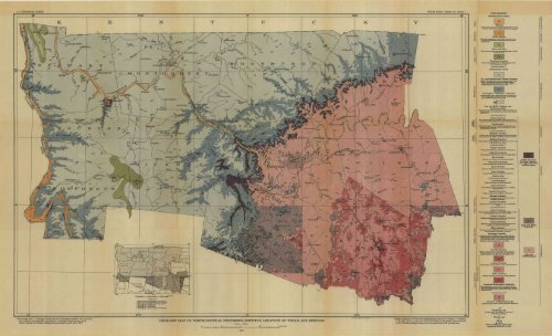
GEOLOGIC MAP OF <strong>NORTH</strong>-<strong>CENTRAL</strong> <strong>TENNESSEE</strong>, SHOW<strong>IN</strong>G LOCATION OF WELLS AND SPR<strong>IN</strong>GS<br />
Scale 250,000<br />
5<br />
1932<br />
10 15 MILES<br />
WILLIAMS A HE<strong>IN</strong>TZ CO,WASH.D.C.<br />
Geology compiled by A. M. Piper from detailed geologic maps by R. S. Bassler, J. J. Galloway,<br />
C. W. Hayes, and E. 0. Ulrich, also from the third edition of the geologic map of Tennessee<br />
by the Tennessee Geological Survey, with minor adjustments to the corrected base<br />
Ji<br />
ft!<br />
;s<br />
EXPLANATION<br />
UNCONSOL1DATED ROCKS<br />
(Gravel, sand, and silt, composing flood plains of major<br />
streams; deposits on secondary streams not mapped)<br />
Terrace deposits<br />
(Hounded to subangular gravel, sand, and silt on river<br />
terraces; locally several hundred feet above present<br />
Eutaw formation<br />
(Red micaceous sand with interstratified layers of clay<br />
Tuscaloosa formation<br />
(Gravel derived from chert of Mississippian rocks.<br />
with little sand and clay)<br />
UNCONFORMITY<br />
CONSOLIDATED ROCKS<br />
St. Louis limestone and Warsaw formation<br />
(Massive fine-grained gray to blue limestone (St. Louis)<br />
above; thick-bedded coarsely crystalline sandy or<br />
cherty limestone (Warsaw) below. Both weather to<br />
reddish clay with loose chert fragments)<br />
Cfp<br />
__J<br />
Fort Payne ("Tullahoma") formation<br />
(Siliecowi ahale, chert, flint, and cherty crinoidal lime<br />
stone of'extremely variable character; progressively<br />
more argillaceous from west to east)<br />
New Providence, Ridgetop, and<br />
Chattanooga shales<br />
(Limestone and greenish clay shale (New Providence a-nd<br />
Ridgetop) above and carbonaceous black shale (Chatta<br />
nooga) below)<br />
UNCONFORMITY<br />
Pegram limestone<br />
(Thick-bedded light-gray limestone with coarse-grained<br />
sandstone at base locally ; forms small violated outcrops)<br />
Camden chert<br />
(Alternating layers of dense bluish-gray limestone and<br />
yellowish chert; known at only two localities in south<br />
ern Humphreys County)<br />
UNCONFORMITY<br />
Harriman (?) chert<br />
(White, gray, and buff nonfossUiferous chertv limestone,<br />
known only in the Wells Cresk Basin, Stewart County)<br />
Birdsong limestone<br />
(Thin-bedded cherty fossHiferous limestone; known only<br />
in the Wells Creek Basin)<br />
UNCONFORMITY<br />
Decatur limestone<br />
(Thick-bedded light-gray relatively pure limestone)<br />
Lobelville formation<br />
(Thin-bedded earthy limestone and variegated shale)<br />
Bob formation<br />
(Massive pure limestone and variegated shale)<br />
Beech River formation<br />
(Calcareous shale and shaly cherty limestone)<br />
Dixon limestone<br />
(Earthy red limestone and red and purple shale)<br />
Lego limestone<br />
(Compact light-gray miitcrystalline limestone)<br />
Waldron shale<br />
(Light-gray shaly limestone)<br />
Laurel limestone<br />
(Massive purple and reddish limestone)<br />
Osgood limestone<br />
(Thi-n-beddrd compact light-gray, blue, or reddish<br />
earthy limestone)<br />
Brassfield limestone<br />
(White or blue cherty fossiliferous limestone)<br />
Fernvale formation<br />
(Soft green or chocolate-colored shale with bands of<br />
crystalline limestone)<br />
Arnheim formation<br />
(Blue granular crystalline limestone and interbedded<br />
shale)<br />
UNCONFORMITY<br />
Leipers limestone<br />
(Knotty earthy limestone and interbedded shale, or gran<br />
ular crystalline limestone without shale)<br />
Catheys limestone<br />
(Knotty earthy limestone and shale with thick bands<br />
of impure blue limestone)<br />
Cannon limestone<br />
(Massivs pure dove-colored and gray limestone, also<br />
argillaceous cherty blue limestone)<br />
Bigby limestone<br />
(Mainly granular crystalline gray or brown laminated<br />
and cross-bedded phosphatic limestone)<br />
Hermitage formation<br />
(At western edge of Nashville Basin, chiefly medium-<br />
bedded sandy and phosphatic subgranular limestone<br />
with local beds of shale. Toward the northeast and<br />
east grades into flaggy blue-gray sandy and earthy<br />
limestone, calcareous sandstone, and shale)<br />
Lowville limestone<br />
(Massive compact white or light-blue cherty limestone<br />
(Carters limestone member) with thin-bedded dovecolored<br />
limestone and yellowish-gray shale at top)<br />
Lebanon limestone<br />
(Thin-bedded compact bluish or dove-colored limestone)<br />
Ridley limestone<br />
(Massive fine-grained blue-gray cherty limestone)<br />
Pierce and Murfreesboro limestones<br />
(Thin-bedded blus or drab brittle limestone with local<br />
thick beds of bluish-brown coarse crystalline limestone<br />
(Piercs) overlying massive brittle drab cherty limestone<br />
(Murfreesboro))<br />
UNCONFORMITY<br />
Limestone of Beekmantown age<br />
(Light-gray fine-grained cherty magnesian limestone)<br />
+SO<br />
o<br />
Nonflowing well<br />
(Number refers to description in text and<br />
in tabulated well data)<br />
Flowing well<br />
Spring<br />
Well or spring for which water<br />
analysis is tabulated in text<br />
Middle and Lower<br />
Devonian, Silurian,<br />
and Upper Ordovician<br />
undifferentiated<br />
Upper and Middle<br />
Ordovician<br />
Ordovician<br />
undifferentiated<br />
z<br />
o:<br />
ui<br />
r-<br />
o:<br />
o:<br />
U)<br />
D<br />
O<br />
UJ<br />
U<br />
<<br />
Ul<br />
a<br />
u<br />
(I)<br />
D<br />
o<br />
IE<br />
111<br />
U.<br />
Z<br />
O<br />
u<br />
Z<br />
o Ul<br />
0<br />
o<br />
o IT<br />
O


