

GROUND WATER IN NORTH-CENTRAL TENNESSEE
GROUND WATER IN NORTH-CENTRAL TENNESSEE
GROUND WATER IN NORTH-CENTRAL TENNESSEE

Create successful ePaper yourself
Turn your PDF publications into a flip-book with our unique Google optimized e-Paper software.
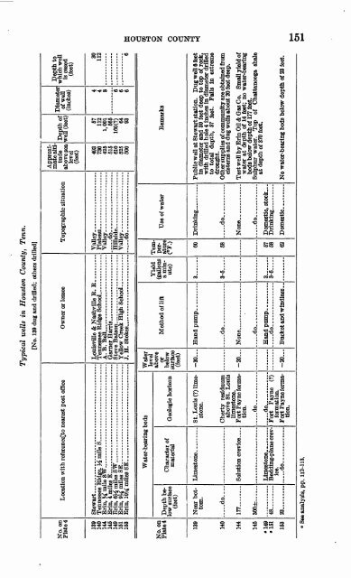
Typical wells in Houston County, Tenn.<br />
[No. 139 dug and drilled; others driHed]<br />
Depth to<br />
which well<br />
is cased<br />
(feet)<br />
Diameter<br />
of well<br />
(inches)<br />
Depth of<br />
well (feet)<br />
Approximatealtitude<br />
above sea<br />
level<br />
(feet)<br />
Topographic situation<br />
Owner or lessee<br />
Location with referencelto nearest post office<br />
No. on<br />
Plate 4<br />
30<br />
112<br />
57<br />
112<br />
1,001<br />
565<br />
6<br />
4<br />
4<br />
8<br />
6<br />
6<br />
160(?)<br />
64<br />
93<br />
493<br />
730<br />
425<br />
515<br />
610<br />
525<br />
500<br />
Vail ey-_ .....<br />
Plat<br />
Vail<br />
Hittside<br />
..... .....<br />
Vailey_<br />
....... ... ......<br />
io- ___ _. . __ .<br />
Lou isville & Nashville R. R<br />
Ten<br />
A T\.<br />
Bell.... ....... ...<br />
Oar<br />
Stev<br />
Yell<br />
j H.<br />
Stokes^ _____ ____ . __ .<br />
Stewart<br />
Tennessee<br />
Erin, % mi le SW. .... ... .... .....<br />
Erin, 4 mil<br />
Erin, % m ilesSW...-....... .......................<br />
Erin, 9J£ m ilesSE _____ . .......................<br />
Erin, 10M iniles<br />
SE ___ .. ____ .. ...... ...<br />
139<br />
140<br />
144<br />
145<br />
149<br />
151<br />
153<br />
Water<br />
level<br />
above<br />
or<br />
below<br />
surface<br />
(feet)<br />
Water-bearing beds<br />
Remarks<br />
Use of water<br />
Temperature<br />
(°F.)<br />
Yield<br />
(gallons<br />
a minute)<br />
Method of lift<br />
Depth below<br />
surface<br />
(feet)<br />
No. on<br />
Plate*<br />
Geologic horizon<br />
Character of<br />
material<br />
Public well at Stewart station. Dug well 6 feet<br />
in diameter and 30 feet deep to top of rock,<br />
with drilled hole 4 inches in diameter drilled<br />
to total depth, 57 feet. Fails in extreme<br />
drought.<br />
Other supplies of community are obtained from<br />
cisterns and dug wells about 20 feet deep.<br />
Test wen by Erin Oil & Gas Co. Small yield of<br />
water at depth of 14 feet; no water-bearing<br />
beds below depth of 177 feet.<br />
Sulphur water. Top of Chattanooga shale<br />
at depth of 370 feet.<br />
60<br />
3<br />
-30<br />
St. Louis (?) limestone.<br />
Near bottom.<br />
139<br />
... -do.. ...<br />
58<br />
3-5<br />
..... do.-<br />
Cherty residuum<br />
above St. Louis<br />
limestone.<br />
Fort Payne formation.<br />
... -do.. ...<br />
do ....... ...<br />
Fort Payne (?)<br />
formation.<br />
Fort Payne formation.<br />
do--<br />
140<br />
None... _<br />
None _ ... __ ...<br />
-20<br />
Solution crevice ....<br />
177<br />
144<br />
... -do..<br />
Domestic, stock.. .<br />
.....do _ ,<br />
300±<br />
145<br />
57<br />
68<br />
3 ...<br />
3-5<br />
.....do __ ___<br />
No water-bearing beds below depth of 23 feet.<br />
62<br />
-20<br />
Bedding-plane crevice,<br />
do<br />
48<br />
23<br />
"149<br />
151<br />
153<br />
1 See analysis, pp. 112-113.


