

GROUND WATER IN NORTH-CENTRAL TENNESSEE
GROUND WATER IN NORTH-CENTRAL TENNESSEE
GROUND WATER IN NORTH-CENTRAL TENNESSEE

Create successful ePaper yourself
Turn your PDF publications into a flip-book with our unique Google optimized e-Paper software.
to<br />
00<br />
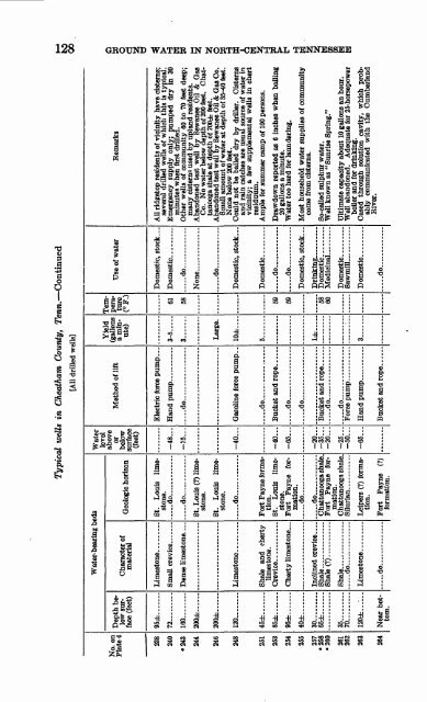
Typical wells in Cheatham County, Tenn. Continued<br />
[All drilled wells]<br />
Water<br />
level<br />
above<br />
or<br />
below<br />
surface<br />
(feet)<br />
Water-bearing beds<br />
Remarks<br />
Use of water<br />
Temperature<br />
(°F.)<br />
Yield<br />
(gallons<br />
a minute)<br />
Method of lift<br />
Depth belowsurface<br />
(feet)<br />
No. on<br />
Plate 4<br />
Geologic horizon<br />
Character of<br />
material<br />
All ridgetop residents of vicinity have cisterns;<br />
several drilled wells of which this is typical.<br />
Emergency supply only; pumped dry in 30<br />
minutes when first drilled.<br />
Other wells of community 60 to 70 feet deep;<br />
many cisterns used by upland residents.<br />
Abandoned test well by Sewanee Oil & Gas<br />
Co. No water below depth of 200 feet. Chattanooga<br />
shale at depth of 700± feet.<br />
Abandoned test well by Sewanee Oil & Gas Co.<br />
Small amount of water at depth of 35-40 feet.<br />
None below 200 feet.<br />
Could not be bailed dry by driller. Cisterns<br />
and rain catches are usual source of water in<br />
vicinity; a few supplemental wells in chert<br />
residuum.<br />
Ample for summer camp of 100 persons.<br />
Drawdown reported as 6 inches when bailing<br />
20 gallons a minute.<br />
Water too hard for laundering.<br />
Most household water supplies of community<br />
come from cisterns.<br />
Domestic, stock ...<br />
Electric force pump<br />
Hand pump __<br />
..... do... ..... ... ...<br />
St. Louis limestone.<br />
.do.......<br />
do.-.<br />
St. Louis (?) limestone.<br />
St. Louis limestone.<br />
do.....- ....<br />
Small crevice .......<br />
95±<br />
72.........<br />
do<br />
61<br />
58<br />
3-5 .<br />
3 -<br />
-48...<br />
-75<br />
160........<br />
200± ...<br />
238<br />
240<br />
-243<br />
244<br />
..... do.. ..... .<br />
Large.<br />
200±......<br />
246<br />
Domestic, stock ...<br />
10±<br />
-40<br />
Limestone.--.- __<br />
120. ....<br />
248<br />
5.......<br />
.....do...... ........<br />
Bucket and rope. ... ..<br />
..do, .............<br />
- do..... . _<br />
Fort Payne formation.<br />
St. Louis limestone.<br />
Fort Payne formation.<br />
.... . do......... ....<br />
.....do..<br />
Chattanooga shale.<br />
Fort Payne formation.<br />
Chattanooga shale.<br />
Shale and cherty<br />
limestone.<br />
do............<br />
..... do ....<br />
Domestic, stock...<br />
45±.......<br />
85±. ......<br />
251<br />
253<br />
59<br />
59<br />
-40<br />
-66...<br />
Cherty limestone _<br />
95± ...<br />
40±<br />
254<br />
255<br />
1±<br />
So-called sulphur water.<br />
Well known as "Sunrise Spring."<br />
58<br />
60<br />
-20...<br />
-35...<br />
-20...<br />
Shale<br />
Shale (?). .<br />
30.........<br />
65±.......<br />
257<br />
«258<br />
"260<br />
Ultimate capacity about 10 gallons an hour.<br />
Well abandoned. Adequate for 25-horsepower<br />
boiler and for drinking.<br />
Cased through solution cavity, which probably<br />
communicated with the Cumberland<br />
River.<br />
... ..do.....-.,. .......<br />
-25...<br />
-50<br />
do. .... ....<br />
35.........<br />
70 __ ....<br />
261<br />
262<br />
3... ....<br />
-65<br />
Leipers (?) formation.<br />
Fort Payne (?)<br />
formation.<br />
120±<br />
263<br />
do. .... .<br />
..... do... ... .... ... .<br />
Near bottom.<br />
264


