

GROUND WATER IN NORTH-CENTRAL TENNESSEE
GROUND WATER IN NORTH-CENTRAL TENNESSEE
GROUND WATER IN NORTH-CENTRAL TENNESSEE

Create successful ePaper yourself
Turn your PDF publications into a flip-book with our unique Google optimized e-Paper software.
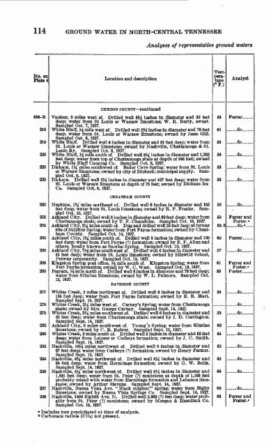
114 <strong>GROUND</strong> <strong>WATER</strong> <strong>IN</strong> <strong>NORTH</strong>-<strong>CENTRAL</strong> <strong>TENNESSEE</strong><br />
No. on<br />
Plate 4<br />
198-B<br />
218<br />
219<br />
220<br />
225<br />
229<br />
243<br />
258<br />
259<br />
260<br />
265<br />
268<br />
269<br />
277<br />
278<br />
279<br />
282<br />
286<br />
292<br />
294<br />
295<br />
Location and description<br />
DICKSON COUNTY continued<br />
Analyses of representative ground waters<br />
deep; water from St Louis or Warsaw limestone; W. R. Berry, owner.<br />
Sampled Oct. 7, 1927.<br />
White Bluff, ^ mile west of.' Drilled well 5% inches in diameter and 75 feet<br />
deep; water from St. Louis or Warsaw limestone; owned by Jesse Gill.<br />
Sampled Oct. 8, 1927.<br />
St. Louis or Warsaw limestone; owned by Nashville, Chattanooga & St.<br />
Louis Ry. Sampled Oct. 8, 1927.<br />
White Bluff, ^ mile south of. Drilled well 8M inches in diameter and 1,383<br />
feet deep; water from top of Chattanooga shale at depth of 246 feet; owned<br />
by White Bluff Canning Co. Sampled Oct. 8, 1927.<br />
or Warsaw limestone; owned by city of Dickson; municipal supply. Sam<br />
pled Oct. 8, 1927.<br />
Dickson. Drilled well 5M inches in diameter and 427 feet deep; water from<br />
St. Louis or Warsaw limestone at depth of 75 feet; owned by Dickson Ice<br />
Co. Sampled Oct. 8, 1927.<br />
CHEATHAM COUNTY<br />
Neptune, 1% miles northeast of. Drilled well 6 inches in diameter and 165<br />
feet deep; water from St. Louis limestone; owned by E. P. Frazier. Sam<br />
pled Oct. 10, 1927.<br />
Ashland City. Drilled well 6 inches in diameter and 69 feet deep; water from<br />
Chattanooga shale; owned by T. F. Chambliss. Sampled Oct. 10, 1927.<br />
Ashland City, 2M miles south of. Dug and drilled well 25 feet deep at former<br />
site of Sulphur Spring; water from Fort Payne formation; owned by Cheat-<br />
ham County. Sampled Oct. 10, 1927.<br />
feet deep; water from Fort Payne (?) formation; owned by E. F. Alien and<br />
others; locally known as Sunrise Spring. Sampled Oct. 10, 1927.<br />
45 feet deep; water from St. Louis limestone; owned by Idlewild School,<br />
Petway community. Sampled Oct. 10, 1927.<br />
Kingston Spring post office, J^ mile south of. Kingston Spring; water from<br />
Fort Payne formation; owned by W. C. West. Sampled Oct. 10, 1927.<br />
water from Silurian limestone; owned by W. L. Palmore. Sampled Oct.<br />
12, 1927.<br />
DAVIDSON COUNTY<br />
Whites Creek, 3 miles northwest of. Drilled well 6 inches in diameter and<br />
158 feet deep; water from Fort Payne formation; owned by E. B. Hart.<br />
Sampled Sept. 14, 1927.<br />
Whites Creek, 2X miles west of. Carney's Spring; water from Chattanooga<br />
shale; owned by Mrs. George Carney. Sampled Sept. 14, 1927.<br />
23 feet deep; water from Chattanooga shale; owned by 3. D. Carrington.<br />
Sampled Sept. 14, 1927.<br />
Ashland City, 8 miles southwest of. Young '.s Spring; water from Silurian<br />
limestone; owned by C. R. Rohrer. Sampled Sept. 13, 1927.<br />
deep; water from Leipers or Catheys formation; owned by J. C. Smith.<br />
Sampled Sept. 14, 1927.<br />
97 feet deep; water from Catheys (?) formation; owned by Henry Farmer.<br />
Sampled Sept. 13, 1927.<br />
Nashville, 4M miles northwest of. Drilled well 6M inches in diameter and<br />
94 feet deep; water from Hermitage formation; owned by Q. W. Bolin.<br />
Sampled Sept. 14, 1927.<br />
1,491 feet deep; water from St. Peter (?) sandstone at depth of 1,165 feet<br />
probably mixed with water from Hermitage formation and Lebanon limestone;<br />
owned by Arthur Stevens. Sampled Sept. 14, 1927.<br />
297 Nashville, Buena Vista Ave. "Black sulphur" spring; water from Bigby<br />
limestone; owned by Buena Vista Springs Co. Sampled Sept. 14, 1927.<br />
298 Nashville, 1400 Eighth Ave. N. Drilled well 2,965 (?) feet deep; water probably<br />
from St. Peter (?) sandstone; owned by Morgan & Hamilton Co.<br />
Sampled Oct. 10, 1927.<br />
° Includes iron precipitated at time of analysis.<br />
* Carbonate radicle (COs) not present.<br />
Tem<br />
pera<br />
ture<br />
C°F.)<br />
58<br />
61<br />
58<br />
58<br />
58<br />
58<br />
58<br />
58 Farrar and<br />
Foster.'<br />
59.5 ..... do.'<br />
60<br />
57<br />
61<br />
58<br />
58<br />
59<br />
60<br />
64<br />
62<br />
62<br />
66<br />
60<br />
68<br />
Analyst<br />
do<br />
.... -do<br />
do<br />
.... .do. -<br />
do .<br />
.... .do<br />
. _ .do...<br />
Farrar and<br />
Foster.'<br />
Foster ......<br />
..... do<br />
do<br />
do<br />
. - do ...<br />
.... -do ...<br />
do- ....<br />
do<br />
do<br />
... ..do ...<br />
Farrar and<br />
Foster.*


