

GROUND WATER IN NORTH-CENTRAL TENNESSEE
GROUND WATER IN NORTH-CENTRAL TENNESSEE
GROUND WATER IN NORTH-CENTRAL TENNESSEE

Create successful ePaper yourself
Turn your PDF publications into a flip-book with our unique Google optimized e-Paper software.
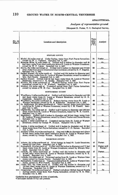
110 <strong>GROUND</strong> <strong>WATER</strong> <strong>IN</strong> <strong>NORTH</strong>-<strong>CENTRAL</strong> <strong>TENNESSEE</strong><br />
No. on<br />
Plate 4<br />
1<br />
6<br />
19<br />
24<br />
27<br />
32<br />
35<br />
42<br />
AA.<br />
TTt<br />
54<br />
57<br />
64<br />
67<br />
68<br />
71<br />
Location and description<br />
STEWABT COUNTY<br />
ANALYTICAL<br />
Analyses of representative ground ;<br />
[Margaret D. Foster, IT. S. Geological Survey,<br />
Model, 5}4 miles west of. Cedar Spring, water from Fort Payne formation;<br />
owned by W. C. Outland. Sampled Oct. 5, 1927.<br />
Bumpus Mills, % mile south of. Drilled well 6 inches in diameter and 48<br />
feet deep; water from chert residuum above St. Louis or Warsaw limestone;<br />
owned by W. P. Luten. Sampled Oct. 5, 1927.<br />
Dover, 5% miles northwest of. Drilled well 6 inches in diameter and 75 feet<br />
deep; water from gravel (weathered chert nodules) ; owned by B . F. Riggins.<br />
Sampled Oct. 5, 1927.<br />
Indian Mound, 4}^ miles north of. Drilled well 5$l inches in diameter and<br />
164 feet deep; water from St. Louis or Warsaw limestone; owned by estate of<br />
Mrs. Bert Smith. Sampled Oct. 4, 1927.<br />
Indian Mound. Drilled well 55 feet deep; water from St. Louis or Warsaw<br />
limestone; owned by C. K. Keatts. Sampled Oct. 4, 1927.<br />
Mobley, 3M miles northwest of. Wofford Spring; water from Fort Payne<br />
formation; owned by J. W. Wofford. Sampled Oct. 5, 1927.<br />
Mobley, 4^4 miles east of. Unnamed spring from Fort Payne formation;<br />
owned by estate of W. H. Cox. Sampled Oct. 5, 1927.<br />
MONTGOMEEY COUNTY<br />
Woodlawn, 5 miles northwest of. Drilled well 551 inches in diameter and 136<br />
feet deep; water from St. Louis or Warsaw limestone; owned by E. B.<br />
Ingraham. Sampled Oct. 4, 1927.<br />
Woodlawn, 5}4 miles northeast of. Britton Spring; water from St. Louis or<br />
Warsaw limestone; owned by H. E. Killebrew. Sampled Oct. 4, 1927.<br />
St. Bethlehem, 2J£ miles southwest of. Idaho Spring; water from alluvium<br />
overlying St. Louis or Warsaw limestone; owned by J. H. Unseld. Sampled<br />
Oct. 4, 1927.<br />
Clarksville, 4}^ miles east of. Drilled well 6 inches in diameter and 162 feet<br />
deep; water from St. Louis or Warsaw limestone, leased by W. R. Corlew.<br />
Sampled Oct. 4. 1927.<br />
Hackberry. Drilled well 6 inches in diameter and 50 feet deep; water from<br />
St. Louis or Warsaw limestone; owned by Henry Yarber and James Broom.<br />
Sampled Oct. 4, 1927.<br />
Louise, 4 miles southwest of. Unnamed spring from St. Louis or Warsaw<br />
limestone; owned by George W. Bryant. Sampled Oct. 4, 1927.<br />
Louise, 5 miles southeast of. Drilled well 5 inches in diameter and 65 feet<br />
deep; water from Fort Payne formation; owned by C. D. Batson. Sampled<br />
Oct. 4, 1927.<br />
Hickory Point, 6M miles northeast of. Dug well 4 fdet in diameter and about<br />
60 feet deep; water from chert residuum above St. Louis or Warsaw limestone;<br />
owned by George Watson. Sampled Oct. 4, 1927.<br />
EOBEETSON COUNTY<br />
73 Adams, S^4 miles northwest of. Mint Spring; in basal St. Louis limestone;<br />
owned by Joel Fort. Sampled Oct. 9, 1927.<br />
81 Springfield, 10 miles north of. Drilled well 5


