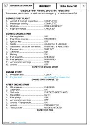
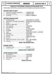
400/500 Series Garmin Optional Displays
400/500 Series Garmin Optional Displays
400/500 Series Garmin Optional Displays

Create successful ePaper yourself
Turn your PDF publications into a flip-book with our unique Google optimized e-Paper software.
Unlighted Obstacles<br />
1000’ AGL<br />
Potential Impact Points<br />
52<br />
Section 2<br />
TAWS Operation<br />
Figure 2-6: TAWS Symbols<br />
Lighted Obstacles<br />
1000’ AGL<br />
TAWS Symbols<br />
The symbols depicted in Figure 2-6 are used to represent obstacles and potential impact points on the<br />
TAWS Page. Note that obstacle symbols are shown on display zoom ranges up to 10 nm.<br />
Color Interpretation<br />
<strong>Garmin</strong> TAWS uses black, yellow, and red to depict terrain information relative to aircraft altitude<br />
(Figure 2-7). Each color is associated with an alert severity level and a suggested course of action. Color<br />
assignments are used by terrain graphics, obstacle symbols, and visual annunciations.<br />
Color TERRAIN/Obstacle Location<br />
Red TERRAIN/Obstacle is within 100’ or<br />
above aircraft altitude.<br />
Yellow TERRAIN/Obstacle is within 1000’<br />
of aircraft altitude.<br />
Black TERRAIN/Obstacle is more than<br />
1000’ below aircraft altitude.<br />
1000' AGL<br />
100' Threshold<br />
Alert Level Suggested Aircrew Response<br />
WARNING Initiate climb and/or turn away from<br />
terrain/obstacle.<br />
CAUTION Be aware of surroundings.<br />
Be prepared to take action.<br />
NO DANGER No action required.<br />
Table 2-1: TAWS Color Symbology<br />
Projected Flight Path<br />
Unlighted Obstacle<br />
Figure 2-7: Terrain Altitude/Color Correlation<br />
Potential Impact Point