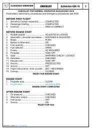
400/500 Series Garmin Optional Displays
400/500 Series Garmin Optional Displays
400/500 Series Garmin Optional Displays

Create successful ePaper yourself
Turn your PDF publications into a flip-book with our unique Google optimized e-Paper software.
WARNING: Terrain data is obtained from third party sources. <strong>Garmin</strong> is not able to independently verify<br />
the accuracy of this data which should be used only as an aid for situational awareness. Terrain data<br />
must not be used as the sole basis for decisions or maneuvers to avoid terrain or obstacles. Terrain<br />
data must not be used for navigation.<br />
CAUTION: Use the <strong>400</strong>/<strong>500</strong> <strong>Series</strong> Units at your own risk. To reduce the risk of unsafe operation, carefully<br />
review and understand all aspects of the Owner’s Manual and the Flight Manual Supplement,<br />
and thoroughly practice basic operation prior to actual use.<br />
CAUTION: The Global Positioning System is operated by the United States government, which<br />
is solely responsible for its accuracy and maintenance. The system is subject to changes which<br />
could affect the accuracy and performance of all GPS equipment. Although <strong>Garmin</strong> <strong>400</strong>/<strong>500</strong><br />
<strong>Series</strong> Units are precision electronic NAVigation AIDS (NAVAID), any NAVAID can be misused or<br />
misinterpreted and therefore become unsafe.<br />
CAUTION: Use the Weather Data Link Interface, TIS, TAWS, and TERRAIN at your own risk. To reduce the<br />
risk of unsafe operation, thoroughly practice basic operation prior to actual use. When in actual use,<br />
carefully compare indications from the <strong>Garmin</strong> unit to all available navigation sources, including the<br />
information from other NAVAIDS, visual sightings, charts, etc. For safety, always resolve any discrepancies<br />
before continuing navigation. The GPS altitude format calculated by the <strong>Garmin</strong> <strong>400</strong>/<strong>500</strong> <strong>Series</strong><br />
units is geometric height above mean sea level and could vary significantly from altitude displayed by<br />
pressure altimeters in aircraft. Never use GPS altitude for vertical navigation.<br />
CAUTION: The Jeppesen database incorporated in the <strong>Garmin</strong> <strong>400</strong>/<strong>500</strong> <strong>Series</strong> Units must be updated<br />
regularly in order to ensure that its information is current. Updates are released every 28 days. A<br />
database information packet is included in your <strong>Garmin</strong> <strong>400</strong>/<strong>500</strong> <strong>Series</strong> Unit package. Pilots using an<br />
out-of-date database do so entirely at their own risk.<br />
CAUTION: The Weather Data Link, TIS, TAWS, and TERRAIN information contained in this Pilot’s Guide<br />
Addendum is not intended to replace the documentation that is supplied with the applicable <strong>Garmin</strong><br />
<strong>400</strong>/<strong>500</strong> <strong>Series</strong> Unit and the GTX 330 Transponder. The user must know how to operate the <strong>400</strong>/<strong>500</strong><br />
<strong>Series</strong> Unit and be knowledgeable of the information in the <strong>400</strong>/<strong>500</strong> Pilot’s Guide.<br />
INTRODUCTION<br />
Warnings and Cautions<br />
TIS CAUTION:<br />
TIS is NOT intended to be used as a collision<br />
avoidance system and does not relieve the<br />
pilot responsibility to “see and avoid” other<br />
aircraft. TIS should not be used for avoidance<br />
maneuvers during IMC or other times<br />
when there is no visual contact with the<br />
intruder aircraft. TIS is intended only to<br />
assist in visual acquisition of other aircraft<br />
in VMC. Avoidance maneuvers are not<br />
recommended, nor authorized, as a<br />
direct result of a TIS intruder display or<br />
TIS alert.<br />
While TIS is a useful aid to visual traffic<br />
avoidance, it has some system limitations that<br />
must be fully understood to ensure proper<br />
use. Many of these limitations are inherent<br />
in secondary radar surveillance. In other<br />
words, the information provided by TIS will<br />
be no better than that provided to ATC.<br />
i