Create successful ePaper yourself
Turn your PDF publications into a flip-book with our unique Google optimized e-Paper software.
The<br />
Volume 2, No. 3<br />
September 2004 2004<br />
SEDIMENTARY<br />
A publication of <strong>SEPM</strong> Society for Sedimentary Geology<br />
Debrite<br />
Gravite<br />
Densite<br />
Record<br />
INSIDE: SEDIMENT GRAVITY FLOWS<br />
PLUS: UPCOMING <strong>SEPM</strong> RESEARCH CONFERENCES<br />
PROGRAM UPDATE FROM NSF - PRESIDENT’S OBSERVATIONS<br />
<strong>Turbid</strong>ite<br />
Debrite<br />
<strong>Turbid</strong>ite
<strong>SEPM</strong> Research Conference<br />
May 21-22, 2005 • Springfield, Missouri<br />
The Sedimentary Record of<br />
Meteorite Impacts<br />
Keynote Address:<br />
Jay Melosh<br />
University of Arizona<br />
Convenors:<br />
Kevin R. Evans<br />
Southwest Missouri State University<br />
J. Wright Hor<strong>to</strong>n<br />
U.S. Geological Survey<br />
Mark Thompson<br />
Kentucky Geological Survey<br />
John Warme<br />
Colorado School of Mines<br />
Featuring talks, posters, and<br />
core study followed by a field<br />
trip* <strong>to</strong> the recently discovered<br />
Weaubleau-Osceola structure.<br />
* Optional field trip <strong>to</strong> Decaturville<br />
and Crooked Creek<br />
structures, May 23, 2005
Debrite<br />
Gravite<br />
Densite<br />
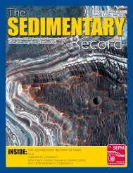
On the Cover: Simplified model for gravites (deposits of sedimentary<br />
gravity flows) and a gravite from a submarine fan deposit in the Permian<br />
Brushy Canyon Formation of west Texas. See the article by Gani, this issue.<br />
CORRECTION:<br />
In the Field Notes article of the June, 2004 issue,<br />
the following references were omitted:<br />
<strong>Turbid</strong>ite<br />
CONTENTS<br />
4 <strong>From</strong> <strong>Turbid</strong> <strong>to</strong> <strong>Lucid</strong>:<br />
A Straightforward Approach <strong>to</strong> Sediment Gravity<br />
Flows and Their Deposits<br />
9 President’s Observations<br />
<strong>SEPM</strong> Members: Readers of the Rocks<br />
10 The Sedimentary Geology and Paleobiology<br />
Program Update from NSF<br />
The Sedimentary Record (ISSN 1543-8740) is published quarterly by the<br />
Society for Sedimentary Geology with offices at 6128 East 38th Street,<br />
Suite 308,Tulsa, OK 74135-5814, USA.<br />
Copyright 2004, Society for Sedimentary Geology.All rights reserved. Opinions<br />
presented in this publication do not reflect official positions of the Society.<br />
The Sedimentary Record is provided as part of membership dues <strong>to</strong> the<br />
Society for Sedimentary Geology.<br />
Mann, K.O. and H.R. Lane, 1995, Graphic Correlation, <strong>SEPM</strong> (Society for Sedimentary Geology), Sp. Pub.<br />
53, 263 pp.<br />
Olson, H.C., A.C. Gary and G.D. Jones, 2003, Similarity curves as indica<strong>to</strong>rs of stratigraphic discontinuities,<br />
in H.C. Olson and R.M. Leckie (eds.), Micropaleon<strong>to</strong>logic proxies for sea-level change and stratigraphic<br />
continuities, <strong>SEPM</strong> (Society for Sedimentary Geology), Sp. Pub. 75, p. 89-96.<br />
O’Neill, B.J., A.E. DuVernay and R.A. George, 1999, Applied palaeon<strong>to</strong>logy: a critical stratigraphic <strong>to</strong>ol in<br />
Gulf of Mexico exploration and exploitation, in R.W. Jones and M.D. Simmons (eds.), Biostratigraphy in<br />
Production and Development Geology, The Geological Society (London), Sp. Pub. 152, p. 303-308.<br />
Russell, R.D. and R.C. Tener, 1981, <strong>SEPM</strong> The First Fifty Years, J. Sed. Pet., v. 51, 1401-1432.<br />
Shaw, A.B., 1964, Time in Stratigraphy, McGraw-Hill, New York, 365 pp.<br />
Wakefield, M.I., 2003, Bio-Sequence stratigraphic utility of SHE diversity analysis, in H.C. Olson and R.M.<br />
Leckie (eds.), Micropaleon<strong>to</strong>logic proxies for sea-level change and stratigraphic continuities, <strong>SEPM</strong> (Society<br />
for Sedimentary Geology), Sp. Pub. 75, p. 81-97.<br />
<strong>Turbid</strong>ite<br />
Debrite<br />
Edi<strong>to</strong>rs<br />
The Sedimentary Record<br />
Loren E. Babcock, Department of Geological Sciences,<br />
The Ohio State University, Columbus, Ohio 43210<br />
<br />
Stephen A. Leslie, Department of Earth Science, University of<br />
Arkansas at Little Rock, Little Rock, Arkansas 72204<br />
<br />
Marilyn D. Wegweiser, Bucking Dinosaur Consulting;<br />
P.O. Box 243; Powell, WY, 82435;<br />
<br />
<strong>SEPM</strong> Staff<br />
6128 East 38th Street, Suite #308,Tulsa, OK 74135-5814<br />
Phone (North America): 800-865-9765<br />
Phone (International): 918-610-3361<br />
Dr. Howard Harper, Executive Direc<strong>to</strong>r<br />
<br />
Theresa Scott, Business Manager<br />
<br />
Kris Farnsworth, Publications Coordina<strong>to</strong>r<br />
<br />
Judy Tarpley, Event and Conference Manager<br />
<br />
Michele Woods, Membership Services Associate<br />
<br />
<strong>SEPM</strong> Council<br />
J. Frederick Sarg, President<br />
<br />
William A. Morgan, President-Elect<br />
<br />
Lesli J. Wood, Secretary-Treasurer<br />
<br />
Serge P. Berne, International Councilor<br />
<br />
Stephen A. Leslie, Councilor for Paleon<strong>to</strong>logy<br />
<br />
Maria Mutti, Councilor for Sedimen<strong>to</strong>logy<br />
<br />
Vi<strong>to</strong>r Abreu, Councilor for Research Activities<br />
<br />
Kitty Lou Milliken, Co-edi<strong>to</strong>r, JSR<br />
<br />
Colin P. North, Co-edi<strong>to</strong>r, JSR<br />
<br />
Chris<strong>to</strong>pher G. Maples, Edi<strong>to</strong>r, PALAIOS<br />
<br />
Laura J. Crossey, Edi<strong>to</strong>r, Special Publications<br />
<br />
Tim Carr, President, <strong>SEPM</strong> Foundation<br />
<br />
www.sepm.org<br />
September 2004 | 3
The Sedimentary Record<br />
<strong>From</strong> <strong>Turbid</strong> <strong>to</strong> <strong>Lucid</strong>:<br />
A Straightforward Approach <strong>to</strong> Sediment<br />
Gravity Flows and Their Deposits<br />
M. Royhan Gani<br />
Department of Geosciences<br />
University of Texas at Dallas<br />
P.O. Box, 830688, Richardson, TX, 75083-0688, USA<br />
mrg013000@utdallas.edu<br />
ABSTRACT<br />
Deepwater sediment gravity flows are categorized on the basis of a combination of four<br />
parameters – sediment concentration, sediment-support mechanism, flow state (laminar<br />
or turbulent), and rheology. Because there is no agreement among sedimen<strong>to</strong>logists<br />
about which of these parameters should be the decisive one, one school’s turbidites<br />
become another school’s debrites, and vice-versa. Except for rheology, all of these<br />
parameters change gradationally from one end member <strong>to</strong> another.Therefore, rheological<br />
classification of sediment gravity flows should be the most straightforward and the<br />
least controversial.These flows can be either New<strong>to</strong>nian (i.e., turbidity currents), or<br />
non-New<strong>to</strong>nian (i.e., debris flows). However, identification of flow rheology by examining<br />
the deposits may not be easy.Although we may confidently identify some rocks as turbidites<br />
and others as debrites, there are some transitional deposits, here called densites,<br />
that share both the characteristics of turbidites and debrites. Densites are the deposits<br />
of dense flows, which are rheologically stratified flows having a composite rheology of<br />
New<strong>to</strong>nian fluids and non-New<strong>to</strong>nian fluids. Moreover, the absence of a general term for<br />
all types of sediment gravity flow deposits has resulted in overuse and misuse of the<br />
term turbidite.The term ‘gravite’ is proposed here for deposits of any kind of sediment<br />
gravity flow, irrespective of their depositional environment.<br />
INTRODUCTION<br />
The term ‘turbidity current’ was introduced<br />
by Johnson (1938) and applied <strong>to</strong> a current<br />
generated due <strong>to</strong> turbid or muddy water.<br />
Later, Kuenen (1957) introduced the term<br />
‘turbidite’ for the deposit of a turbidity current,<br />
and Bouma (1962) introduced a classic<br />
five-fold vertical facies model for turbidites.<br />
Soon, the terms ‘turbidites,’ ‘Bouma<br />
sequences,’ and ‘deepwater deposits’ became<br />
almost synonymous in many published<br />
accounts. Although the overuse and misuse of<br />
the terms ‘turbidity current’ and ‘turbidite’<br />
was first indicated by Sanders (1965), the turbidite<br />
controversy has recently caught wide<br />
attention (e.g., Shanmugam, 2000; Lowe and<br />
Guy, 2000; Kneller and Buckee, 2000; Mulder<br />
and Alexander, 2001).<br />
Sediment gravity flows play a major role in<br />
transporting and depositing sediments in<br />
deepwater environments, and can be defined<br />
as a complex mixture of sediment and fluid<br />
that flows down slope due <strong>to</strong> the action of<br />
gravity. Sediment gravity flows are different<br />
from fluid gravity flows, because in the latter,<br />
4 | September 2004<br />
fluid is moved by gravity dragging the sediment<br />
along, whereas in former gravity moves<br />
the sediment, which drags the fluid along. A<br />
turbidity current is only one type of sediment<br />
gravity flow. The center point of the turbidite<br />
controversy lies in the classification scheme of<br />
sediment gravity flows, which is so far poorly<br />
constrained and a bit ambiguous. This controversy<br />
can lead <strong>to</strong> erroneous numerical modeling<br />
of sediment gravity flows frequently used<br />
in submarine construction and hydrocarbon<br />
exploration because specific mathematical formulae<br />
govern specific types of sediment gravity<br />
flows. Therefore, it is felt that this classification<br />
scheme needs <strong>to</strong> be reviewed <strong>to</strong> clarify the<br />
controversy. In this paper, I take a simple and<br />
straightforward approach <strong>to</strong> classifying sediment<br />
gravity flows. I also suggest some key<br />
depositional features on which flow types can<br />
be interpreted least equivocally. Although the<br />
suggestions made here are applicable irrespective<br />
of depositional environments, this paper<br />
mainly deals with deepwater sediment gravity<br />
flows and their deposits.<br />
CLASSIFICATION OF<br />
SEDIMENT GRAVITY<br />
FLOWS: BACKGROUND<br />
AND REVIEW<br />
The initial definitions of turbidity currents<br />
and debris flows were purely descriptive, without<br />
being specific about the physical properties<br />
of the current. Therefore, from the beginning,<br />
questions revolved around what should<br />
be the main basis of classification of sediment<br />
gravity flows. Different authors emphasized<br />
different parameters in their classification<br />
schemes (sediment concentration: Bagnold,<br />
1962; rheology: Dott, 1963; fluid turbulence:<br />
Sanders, 1965; sediment-support mechanisms:<br />
Middle<strong>to</strong>n and Hamp<strong>to</strong>n, 1973; combination<br />
of rheology and sediment-support mechanism:<br />
Lowe, 1982; combination of physical flow<br />
properties and sediment-support mechanism:<br />
Mulder and Alexander, 2001). Among the<br />
four most important parameters (sediment<br />
concentration, sediment-support mechanism,<br />
flow state, and rheology) of sediment gravity<br />
flows, sediment concentration (by volume)<br />
directly affects other three parameters.<br />
Therefore, sediment concentration appears <strong>to</strong><br />
be the most pragmatic parameter for defining<br />
the various types. Unfortunately, we can not<br />
establish specific threshold values for various<br />
types of sediment gravity flows (Shanmugam,<br />
1996) because grain size and concentration of<br />
clay minerals offset these threshold values.<br />
Sediment-support mechanisms include<br />
matrix strength, dispersive grain pressure,<br />
escaping pore fluid, and fluid turbulence.<br />
These mechanisms may change gradationally<br />
with increasing fluid content, and more than<br />
one support mechanism may operate simultaneously<br />
for a specific type of sediment gravity<br />
flow. Similarly, the flow state may change gradationally<br />
and back-and-forth between a laminar<br />
state and a turbulent state with the change<br />
of sediment concentrations or basin slopes.<br />
On the other hand, the rheology of sediment<br />
gravity flows is expressible in a straightforward<br />
and simplified mathematical way in a 2-D<br />
graph (Fig. 1). Most importantly, the rheological<br />
types do not vary gradationally among<br />
each other. Therefore, rheology may be the<br />
one parameter that can be used least ambiguously<br />
<strong>to</strong> define various types of sediment gravity<br />
flows.<br />
According <strong>to</strong> Figure 1, there are only two<br />
basic types of rheology in sediment gravity<br />
flows – New<strong>to</strong>nian and non-New<strong>to</strong>nian. If a<br />
sediment gravity flow deforms instantly with<br />
applied stress and develops a linear relationship<br />
between shear stress and strain rate, it is<br />
called a New<strong>to</strong>nian fluid. Any deviation from<br />
this characteristic results in non-New<strong>to</strong>nian
Shear stress<br />
Yield strength<br />
Cohesive debris flow<br />
<strong>Turbid</strong>ity current<br />
rheology. Sediment gravity flows can show two<br />
types of non-New<strong>to</strong>nian rheology (Fig. 1). In<br />
a non-New<strong>to</strong>nian Bingham plastic, a critical<br />
value of shear stress (called yield stress) has <strong>to</strong><br />
be crossed before there is any deformation,<br />
after which the deformation is linear (i.e., a<br />
Bingham plastic is a combination of an ideal<br />
plastic and a New<strong>to</strong>nian fluid). In a non-<br />
New<strong>to</strong>nian dilatant fluid there is no yield<br />
strength, but the deformation is nonlinear<br />
with applied stress in such a way that it<br />
becomes progressively harder <strong>to</strong> deform the<br />
fluid (Fig. 1). Applying the above concepts, I<br />
recommend that sediment gravity flows with<br />
New<strong>to</strong>nian rheology should be called ‘turbidity<br />
currents,’ and those with non-New<strong>to</strong>nian<br />
rheology should be called ‘debris flows’ (Fig.<br />
1). Debris flows can be divided further in<strong>to</strong><br />
‘cohesive debris flows’ (non-New<strong>to</strong>nian<br />
Bingham plastics), and ‘non-cohesive debris<br />
flows’ (non-New<strong>to</strong>nian dilatant fluids) (Fig.<br />
1). This ‘cohesiveness’ of debris flows generally<br />
depends on the clay concentration of the<br />
flows. Although some workers (e.g.,<br />
Hamp<strong>to</strong>n, 1975; Baas and Best, 2002)<br />
showed that as little as 2-4% clay (by volume)<br />
can generate yield strength in the flows, further<br />
research is needed <strong>to</strong> clarify the matter. So<br />
far, we know the least about the numerical and<br />
experimental modeling of non-New<strong>to</strong>nian<br />
dilatant sediment gravity flows (e.g., grain<br />
flows) and their deposits. I suspect that it is a<br />
critical loophole in understanding the evolution<br />
of sediment gravity flows; hence it is an<br />
(Non-New<strong>to</strong>nian Bingham Plastic)<br />
(New<strong>to</strong>nian fluid)<br />
Non-cohesive debris flow<br />
Strain rate (du/dy)<br />
(Non-New<strong>to</strong>nian dilatant fluid)<br />
Figure 1. Basic types of rheology in sediment gravity flows. According <strong>to</strong> this diagram, turbidity currents<br />
are New<strong>to</strong>nian fluids, whereas debris flows are not. Debris flows can be either non-New<strong>to</strong>nian Bingham<br />
plastics (cohesive debris flows; e.g., mud flows) with a certain yield strength, or non-New<strong>to</strong>nian dilatant<br />
fluids (non-cohesive debris flows; e.g., grain flow) without any yield strength.<br />
issue of turbidite controversy.<br />
It may be easy <strong>to</strong> determine the rheology of<br />
flows in the labora<strong>to</strong>ry. However, interpreting<br />
Grain size<br />
B<br />
A<br />
Reynolds number<br />
Laminar Turbulent<br />
Gravel<br />
Coarse sand<br />
Fine sand<br />
Silt<br />
Clay<br />
4<br />
10<br />
3<br />
10<br />
2<br />
10<br />
0<br />
1<br />
10<br />
Non-New<strong>to</strong>nian dilatant fluid<br />
?<br />
New<strong>to</strong>nian fluid<br />
? ?<br />
0 10 20 30 40 50 60 70 80 90<br />
<strong>Turbid</strong>ity current<br />
(Hybrid of<br />
turbidity current<br />
and non-cohesive<br />
debris flow)<br />
10<br />
0.1 Subcritical 1 Supercritical<br />
Froude number<br />
The Sedimentary Record<br />
the flow rheology of a deposit by examining<br />
its depositional features may be challenging.<br />
There are sediment gravity flow deposits that<br />
share both the characters of turbidites and<br />
debrites (deposits of debris flows). If we follow<br />
the turbidite controversy for the last ten years,<br />
it becomes obvious that these hybrid deposits<br />
are the main issue of debate. A plethora of terminology<br />
(e.g., high density turbidity currents,<br />
sandy debris flows, slurry flows, concentrated<br />
density flows) has been applied <strong>to</strong> these<br />
rocks. Most of these deposits originate from<br />
rheologically stratified (or bipartite) sediment<br />
gravity flows (e.g., Sanders, 1965; Tinterri et<br />
al., 2003) with commonly a lower zone of<br />
non-New<strong>to</strong>nian dilatant fluid (non-cohesive<br />
debris flow) overlain by a New<strong>to</strong>nian fluid<br />
(turbidity current). Because these types of<br />
flows can frequently change the intra-flow rheological<br />
boundaries, and can generate a single<br />
event bed, a separate name is needed for these<br />
flows and their deposits. In this study, these<br />
flows are called ‘dense flows’ (after Allen,<br />
1997), as they show an intermediate density<br />
(due <strong>to</strong> intermediate sediment concentration)<br />
between turbidity currents and debris flows<br />
(Fig. 2A), and their deposits are named ‘densites.’<br />
However, it is emphasized that according<br />
<strong>to</strong> rheology there are only two basic types<br />
Bingham plastic Figure 2.<br />
Distribution of different<br />
types of sediment<br />
gravity flows<br />
in 2-D space of sediment<br />
concentration<br />
vs. grain size (A),<br />
Dense flow Debris flow<br />
and Reynolds number<br />
vs. Froude number<br />
(B). Note that<br />
dense flows (rheologically<br />
stratified sediment<br />
gravity flows)<br />
20 30 40 50 60 70 80 90<br />
Sediment concentration (% by volume)<br />
100 occupy an intermediate<br />
position<br />
between turbidity<br />
currents and debris<br />
flows. For conven-<br />
<strong>Turbid</strong>ity current<br />
ience, rheological<br />
types are shown for<br />
possible operational<br />
ranges of sediment<br />
Dense flow<br />
concentrations; however,<br />
the percentage<br />
of clay within the<br />
bulk sediments (not<br />
shown in Fig. 2A) is<br />
Debris flow<br />
an important fac<strong>to</strong>r<br />
controlling the flow<br />
rheology (after Allen,<br />
1997).<br />
10<br />
September 2004 | 5
The Sedimentary Record<br />
Increasing fluid content<br />
of sediment gravity flows – turbidity currents<br />
and debris flows.<br />
As mentioned earlier, there are no threshold<br />
values of sediment concentration (by volume)<br />
in constraining the types of sediment gravity<br />
flows. A range of sediment concentration values,<br />
which can vary according <strong>to</strong> grain size, is<br />
suggested for turbidity currents, dense flows,<br />
and debris flows (Fig. 2A). In general, with<br />
increasing sediment concentration, a turbidity<br />
current can transform in<strong>to</strong> a dense flow, and<br />
then in<strong>to</strong> a debris flow. Similarly, depending<br />
on the Froude numbers, these three flows can<br />
be both turbulent and laminar (Fig. 2B).<br />
However, turbidity currents are mostly turbulent,<br />
whereas debris flows are mostly laminar.<br />
Based on flow rheology and incorporating<br />
the concept of dense flows, a simplified tabular<br />
classification of sediment gravity flows is generated<br />
(Fig. 3). Because most of the sediment<br />
gravity flows originate from slides and slumps,<br />
these are included at the bot<strong>to</strong>m of this classification.<br />
The classification also shows the dominant<br />
sediment-support mechanism and flow<br />
state for each of the types <strong>to</strong> give a comprehensive<br />
picture about the nature of these flows.<br />
DIAGNOSTIC FEATURES OF<br />
DIFFERENT SEDIMENT<br />
GRAVITY FLOW DEPOSITS<br />
One reason for the turbidite controversy is the<br />
lack of consensus among sedimen<strong>to</strong>logists<br />
6 | September 2004<br />
Rheology Flow Type Deposits<br />
New<strong>to</strong>nian<br />
fluid<br />
Variable<br />
(Partly non-<br />
New<strong>to</strong>nian fluid,<br />
partly New<strong>to</strong>nian<br />
fluid)<br />
Non-New<strong>to</strong>nian<br />
dilatant fluid<br />
Bingham<br />
plastic<br />
Bingham plastic<br />
<strong>Turbid</strong>ity<br />
current<br />
(mostly<br />
turbulent)<br />
Dense flow<br />
(partly laminar,<br />
partly turbulent)<br />
Debris flow<br />
(mostly<br />
laminar)<br />
Subcatagories:<br />
- Low-concentration (
Debrite<br />
mechanisms of flows suggest a number of<br />
links, which, in turn, point <strong>to</strong> a set of key<br />
depositional features for each type of sediment<br />
gravity flow deposits (Fig. 4). Based on these<br />
diagnostic features, the concepts described in<br />
the previous section, and on numerous published<br />
works, I suggest the following terminology<br />
be applied for the deposits of different<br />
sediment gravity flows.<br />
Gravite<br />
Gravite is defined as a sediment or rock<br />
deposited from a sediment gravity flow (Gani,<br />
2003). It is an umbrella term that incorporates<br />
all sediment gravity flow deposits (including<br />
slide and slump deposits) irrespective of their<br />
depositional environment (Fig. 5). The<br />
absence of such a concise, general term resulted<br />
in overuse and misuse of the term ‘turbidite’<br />
in geological literature. For example,<br />
although submarine fans consist of different<br />
types of sediment gravity flow deposits, the<br />
term ‘turbidite systems’ has been used interchangeably<br />
with ‘submarine fan systems’ (e.g.,<br />
Bouma and S<strong>to</strong>ne, 2000). When the assignment<br />
of sediment gravity flow deposits <strong>to</strong> any<br />
particular types is either problematic (due <strong>to</strong><br />
preservational bias, poor outcrop quality, etc.)<br />
or unnecessary, the term gravite can be used<br />
conveniently without creating any debate of<br />
the recent kind. Gravites exclude deposits of<br />
fluid gravity flows.<br />
Debrite<br />
Debrites, a class of gravites, are deposits of<br />
debris flows. Traditionally, debris flows are<br />
regarded as moving mass of rock clasts, clay<br />
minerals, and water. Although debris flows are<br />
commonly regarded as plastic flows (e.g.,<br />
Gravite<br />
Densite<br />
Lowe, 1982), there are other views that support<br />
non-New<strong>to</strong>nian fluid rheology (e.g.,<br />
Allen, 1997). In this study, for the sake of simplicity,<br />
I consider debris flows as sediment<br />
gravity flows whose rheology is not<br />
New<strong>to</strong>nian (Fig. 1). Therefore, debrites can<br />
include both cohesive debrites (Bingham plastic<br />
rheology) and non-cohesive debrites (non-<br />
New<strong>to</strong>nian dilatant fluid rheology). In general,<br />
a gravite bed that does not show any distribution<br />
grading even in the uppermost part is a<br />
debrite (Fig. 5). Cohesive debrites are relatively<br />
easy <strong>to</strong> identify. Most importantly, because<br />
of the yield strength of the flow, they contain<br />
‘floating,’ outsized clasts in a muddy matrix<br />
(Figs. 5A, 6A). These deposits show poor sorting<br />
with rare, if any, coarse-tail grading. On<br />
the other hand, non-cohesive debrites are relatively<br />
mud-free sands<strong>to</strong>nes (e.g., grain flow<br />
deposits) that show inverse grading because of<br />
the dispersive grain pressure (Fig. 5C).<br />
Generally, non-cohesive debrites aggrade layer<br />
by layer (~
The Sedimentary Record<br />
Debrite<br />
A<br />
Densite<br />
B<br />
<strong>Turbid</strong>ite<br />
C<br />
5 cm<br />
3 cm<br />
14 cm<br />
Figure 6. (A) Wackes<strong>to</strong>ne cohesive debrite in the<br />
base-of-slope deposits of Permian Lamar<br />
Limes<strong>to</strong>ne Member, Guadalupe Mountains,<br />
west Texas. Poorly sorted skeletal grains floating<br />
within matrix mud along with ungraded and<br />
sharp upper boundary indicate a Bingham plastic<br />
rheology of the depositing flow. Compare with<br />
Fig. 5A. (B) Delta front densite in the Upper<br />
Cretaceous Wall Creek Formation of central<br />
Wyoming. The lower layer of this bed is ungraded<br />
with floating mud clasts, hence indicates non-<br />
New<strong>to</strong>nian flow rheology. The upper layer shows<br />
distribution grading with flat stratification indicating<br />
New<strong>to</strong>nian flow rheology. Note that as<br />
bedding plane has not developed between these<br />
two layers, the entire bed is called a densite<br />
(hybrid of debrite and turbidite; compare with<br />
Figs. 5E-F). (C) <strong>Turbid</strong>ite in Miocene base-ofslope<br />
deposits of the Bengal Basin, Bangladesh<br />
(modified from Gani and Alam, 1999). The<br />
entire bed shows distribution grading with the<br />
development of Bouma T abc divisions and without<br />
any floating clasts in T a division. These indicate<br />
differential grain settling from a New<strong>to</strong>nian<br />
fluid. Compare with Fig. 5G.<br />
rents’ are densites (Figs. 5D-F). However, the<br />
<strong>to</strong>p part of these deposits should show normal<br />
grading (e.g., Baas, 2004), otherwise they are<br />
debrites. The only real-world example of<br />
quasi-steady turbidity currents are the hyperpycnal<br />
flows produced during river floods.<br />
These hyperpycnites show reverse-then-nor-<br />
8 | September 2004<br />
<strong>Turbid</strong>ite<br />
Debrite<br />
Tc<br />
Tb<br />
Ta<br />
mal grading analogous <strong>to</strong> a waxing-then-waning<br />
flood hydrograph (Mulder et al., 2003;<br />
Fig. 5H). Hyperpycnal flows are regarded as<br />
low-concentration (0.2-3% by volume) and<br />
medium-grained turbidity currents (Fig. 3).<br />
Therefore, their deposits (Fig. 5H) should not<br />
be confused with deposits of dense flows (Figs.<br />
5D-F). However, more study is needed for<br />
successful identification of ancient hyperpycnites.<br />
Future research is also necessary in order<br />
<strong>to</strong> identify deposits of fluid muds commonly<br />
developed on modern continental shelves<br />
(Traykovski et al., 2000) from ancient records.<br />
Because sediment concentration of fluid muds<br />
is very low (
PRESIDENT’S OBSERVATIONS<br />
<strong>SEPM</strong> MEMBERS:<br />
READERS OF THE ROCKS<br />
Summertime always causes me <strong>to</strong> think about<br />
the field with anticipation and nostalgia.<br />
Sedimentary geologists are, in large measure,<br />
field-based geoscientists. We are the few people<br />
on the planet who interpret the rocks, be<br />
they on Earth, the Moon, or Mars. By doing<br />
this, we have a distinct role <strong>to</strong> play in many of<br />
modern life’s critical endeavors. My doc<strong>to</strong>ral<br />
advisor, Lloyd Pray, would always tell us that if<br />
we could “read the rocks”, we would always<br />
make a contribution and better yet keep a job.<br />
Whether our professional lives involve academia,<br />
government, or industry, and irregardless<br />
of whether it is in energy, minerals, water<br />
resources, or the environment, the ability <strong>to</strong><br />
decipher the origin and his<strong>to</strong>ry of the sedimentary<br />
rocks is a critical element of our<br />
work. Understanding the environments of<br />
deposition, the stratal geometries, diagenetic<br />
alterations, and structural configuration of the<br />
rocks is basic <strong>to</strong> our jobs.<br />
As past-president, John Anderson, stated in<br />
an earlier letter, the first principles of science<br />
and mathematics are absolutely essential <strong>to</strong><br />
modern geoscience and it’s increasing quantification.<br />
There is also no substitute for field<br />
experience. It provides the context and<br />
ground truth for our ideas and for our interpretations<br />
of the subsurface. The field is<br />
where we go <strong>to</strong> test our ideas and concepts. It<br />
provides scale relationships from the seismic<br />
scale (10’s-100’s-m) <strong>to</strong> the reservoir flow unit<br />
scale (m’s). Having just spent ten days in the<br />
field in Australia with our regional exploration<br />
team in Melbourne has reminded me once<br />
again of the value of this experience. The<br />
focus of the trip was <strong>to</strong> introduce a very experienced<br />
exploration group <strong>to</strong> ancient carbonate<br />
platforms using the classic outcrops of the<br />
Devonian of the Canning basin, and <strong>to</strong> expose<br />
them <strong>to</strong> the modern carbonate environments<br />
of the Shark Bay region. Observing the platform<br />
lithofacies, stratal architecture, and paleogeography<br />
of these different carbonate settings<br />
has enhanced their ability <strong>to</strong> interpret<br />
the subsurface by giving them visual images of<br />
scale and geometry, and by giving them<br />
insight in<strong>to</strong> the lateral and vertical stratigraphic<br />
and lithofacies relationships present in carbonate<br />
sequences.<br />
Field mapping is a critical component of<br />
the field experience. It forces us <strong>to</strong> build a<br />
three-dimensional picture of the geology of an<br />
area. It gives us the knowledge and insight<br />
in<strong>to</strong> structure and stratigraphy that are essential<br />
<strong>to</strong> the interpretation of rocks less well<br />
exposed, of strata in the subsurface, and now<br />
even of the rocks of remote places like Mars.<br />
Fieldwork gives us an understanding of sedimentary<br />
environments from deepwater <strong>to</strong> the<br />
fluvial siliciclastics, <strong>to</strong> lacustrine settings, <strong>to</strong><br />
evaporites, and <strong>to</strong> the whole world<br />
of carbonate platforms and basins.<br />
This understanding of the geometry<br />
and continuity of sedimentary<br />
rocks gives us a predictive framework<br />
that among many other<br />
things allows us <strong>to</strong> understand flow<br />
through porous media, whether<br />
that flow is hydrocarbons, water, or<br />
contaminants. Finally, the field is<br />
the database for biostratigraphy. It<br />
provides the basis for building a<br />
time his<strong>to</strong>ry of the crust of the<br />
earth that is essential <strong>to</strong> our understanding,<br />
among other things, the<br />
movement of the continents and<br />
the origin of life.<br />
As students and professionals,<br />
but especially as students, we cannot<br />
get enough field time. There is<br />
much we, as members of <strong>SEPM</strong>,<br />
can do <strong>to</strong> promote the field. I<br />
strongly encourage you all <strong>to</strong> take<br />
every opportunity <strong>to</strong> go <strong>to</strong> the field.<br />
Whatever the venue, field camp,<br />
field trips, or as part of your<br />
research, the more rocks you see the<br />
better a reader of those rocks you’ll<br />
be. Field experience is absolutely<br />
essential <strong>to</strong> the education of a geoscientist,<br />
and every <strong>SEPM</strong> member<br />
should encourage their favorite<br />
University department <strong>to</strong> retain<br />
and enhance field-based programs.<br />
As undergraduate students, seek<br />
out Geoscience Departments for<br />
graduate work that embrace the<br />
field experience. As graduate students<br />
make the field part of your<br />
The Sedimentary Record<br />
thesis. Those of us in the professional ranks<br />
should be proactive in taking students <strong>to</strong> the<br />
outcrop. Field-based work is critical <strong>to</strong> continuing<br />
<strong>to</strong> advance sedimentary geology, and<br />
there will always be work for the “reader of the<br />
rocks”. Have a good rest of the summer, and I<br />
know I’ll see many of you this fall at the GSA<br />
in Denver.<br />
Rick Sarg; President <strong>SEPM</strong><br />
Rick.sarg@exxonmobil.com<br />
September 2004 | 9
The Sedimentary Record<br />
The Sedimentary<br />
Geology and<br />
Paleobiology<br />
Program Update<br />
from NSF<br />
INTRODUCTION<br />
This column is our annual update on activities, opportunities and<br />
changes that are happening at NSF that impact the soon <strong>to</strong> be formalized<br />
Sedimentary Geology and Paleobiology Program at NSF. These are<br />
divided in<strong>to</strong> Organization, People, Budget, Special<br />
Programs/Initiatives, and Program News.<br />
ORGANIZATION<br />
The Geology and Paleon<strong>to</strong>logy Program became three programs beginning<br />
August 1, 2004. These new programs are the Sedimentary<br />
Geology and Paleobiology Program (SGP), Geobiology and<br />
Environmental Geochemistry Program (GEG), and the<br />
Geomorphology and Land Use Dynamics Program (GLD). Other<br />
changes include the establishment of the EarthScope Program, for<br />
which a Program Officer has already been hired. Along with these new<br />
programmatic additions, there is a new organization for the Earth<br />
Science Division. The new organization consists of two sections, the<br />
Surface Earth Processes (SEP) Section and the Deep Earth Processes<br />
(DEP) Section.<br />
PEOPLE<br />
There have been several changes in staffing this year. SGP is staffed by<br />
one full time and one half time Program Direc<strong>to</strong>r—H. Richard Lane<br />
and Paul Filmer, respectively—one science assistant—Shana Pimley—<br />
and one program assistant—Lerome Jackson. Felicia Means, who has<br />
served the Geology and Paleon<strong>to</strong>logy so well for so many years, is now<br />
the Administrative Officer for the Division. In the new organization,<br />
the EAR Division, directed by Hermann Zimmerman, consists of two<br />
sections, SEP and DEP. These are headed by Walter Snyder and Jim<br />
Whitcomb, respectively. Currently, the Division is advertising for a<br />
temporary two-year appointment <strong>to</strong> replace Walter Snyder as the<br />
Section Head for the Surface Earth Processes Section, with an expected<br />
selection after the first of the year. I strongly encourage,…. no plead,<br />
for those in our community who are interested and qualified <strong>to</strong> apply.<br />
Without strong scientific leadership in NSF aligned in our area of the<br />
science, the exciting progress seen in the last couple years will end.<br />
Many other EAR Division staffing changes have occurred in the last<br />
couple years and the current staffing can be found on the NSF website<br />
at www.geo.nsf.gov/ear/start.htm.<br />
BUDGET<br />
As reported last year, Congress and the President had NSF on track for<br />
doubling its budget in 5 years. A number of obvious economic problems<br />
have conspired <strong>to</strong> delay or sidetrack that plan. The overall budget<br />
increase declined for NSF and EAR significantly this year <strong>to</strong> around<br />
1%, for which most increased revenues were applied <strong>to</strong> Earthscope<br />
10 | September 2004<br />
research fund and the geoinformatics initiative. Bot<strong>to</strong>m line is that the<br />
GE and other EAR core programs’ budgets were flat for the fiscal year<br />
2004. Budget requests <strong>to</strong> Congress for GY 2005 represent a 3%<br />
increase, but it appears as though the optimistic scenario is for a flat<br />
budget.<br />
SPECIAL PROGRAMS<br />
There are numerous NSF special programs that should be of interest <strong>to</strong><br />
the SGP community as funding sources. These special programs generally<br />
last for 3-5 years, require multidisciplinary team approaches, and<br />
commonly fund larger requests. Some of these include:<br />
• Collaborations in Mathematical Geosciences (CMG):<br />
www.nsf.gov/pubs/2004/nsf04508/nsf04508.pdf<br />
• Assembling the Tree of Life (ATOL):<br />
www.nsf.gov/bio/progdes/bioa<strong>to</strong>l.htm<br />
• Biocomplexity in the Environment (BE): Integrated Research<br />
and Education in Environmental Systems:<br />
www.nsf.gov/pubs/2002/nsf02167/nsf02167.htm<br />
• Earth System His<strong>to</strong>ry (ESH):<br />
www.nsf.gov/pubs/2004/nsf04597/nsf04597.htm<br />
• Research in the Biogeosciences:<br />
www.geo.nsf.gov/cgi-bin/geo/showprog.pl?id=114&div=ear<br />
• Major Research Instrumentation (MRI):<br />
www.nsf.gov/od/oia/programs/mri/start.htm<br />
• Margins:<br />
www.nsf.gov/pubsys/ods/getpub.cfm?ods_key=nsf02110<br />
• Faculty Early Career Development (CAREER) Program:<br />
www.nsf.gov/pubsys/ods/getpub.cfm?ods_key=nsf02111<br />
NSF/SGP SUPPORTED PROJECTS OF<br />
INTEREST TO THE SEDIMENTARY<br />
GEOLOGY AND PALEOBIOLOGY<br />
COMMUNITIES<br />
Geoinformatics: NSF is emphasizing the need for development of a<br />
cyberinfrastructure across all of science and engineering. The community<br />
has coined the term “GeoInformatics” for cyberinfrastructure<br />
applied <strong>to</strong> the Earth Sciences. GeoInformatics is an information technology<br />
system that will provide earth scientists with the <strong>to</strong>ols necessary<br />
<strong>to</strong> conduct the next generation of geoscience research. GeoInformatics<br />
is designed <strong>to</strong> take advantage of powerful new information technologies<br />
such as Geographical Information Systems (GIS), remote sensing, scientific<br />
visualization, information networks, and wireless applications in<br />
a truly integrated manner.<br />
NCED: The University of Minnesota’s St. Anthony Falls Labora<strong>to</strong>ry<br />
(SAFL), Univ. California—Berkeley, the Science Museum of<br />
Minnesota, MIT, Prince<strong>to</strong>n University, and Fond du Lac Tribal and<br />
Community College have received a five-year (renewable for up <strong>to</strong> 5<br />
additional years) Science and Technology Center (STC) grant from the<br />
NSF for a new National Center for Earth-surface Dynamics (NCED).<br />
www.nced.umn.edu<br />
CHRONOS: CHRONOS aims <strong>to</strong> create a dynamic, interactive and<br />
time-calibrated framework for Earth his<strong>to</strong>ry. CHRONOS’s main objective<br />
is <strong>to</strong> develop a network of databases and visualization and analytical<br />
methodologies that broadly deal with chronostratigraphy. The goal<br />
is not only <strong>to</strong> produce a system for assembling and consolidating such a<br />
wide range of Earth his<strong>to</strong>ry data, but also <strong>to</strong> provide a platform for
modern, innovative Earth science research, and <strong>to</strong> empower the general<br />
public with new knowledge of Earth science facts and issues.<br />
www.chronos.org<br />
EARTHTIME: Recent developments in geochronology and in stratigraphic<br />
correlation suggest that for the first time it will be possible <strong>to</strong><br />
calibrate the entire geologic timescale <strong>to</strong> better than 0.1% back at least<br />
<strong>to</strong> the beginning of the Phanerozoic, 542 million years ago. This effort<br />
will require about a decade of focused work; unprecedented cooperation<br />
between different geochronological labora<strong>to</strong>ries and communitywide<br />
involvement of stratigraphers, geochronologists, geochemists,<br />
magne<strong>to</strong>stratigraphers, and paleon<strong>to</strong>logists. The payoff of this effort is<br />
enormous. www-eaps.mit.edu/earthtime/<br />
THE PALEO PORTAL: This site is a resource for anyone interested in<br />
paleon<strong>to</strong>logy, from the professional in the lab <strong>to</strong> the interested amateur<br />
scouting for fossils, <strong>to</strong> the student in any classroom. Many different<br />
resources are gathered in<strong>to</strong> this single entry “portal” <strong>to</strong> paleon<strong>to</strong>logical<br />
information on the Internet. www.paleoportal.org<br />
GEOSYSTEMS: GeoSystems is a developing community-based initiative<br />
that focuses on the importance of the deep-time perspective for<br />
understanding the complexities of Earth’s atmosphere, hydrosphere,<br />
biosphere and surficial lithosphere using climate as the focus. The proposed<br />
GeoSystems initiative will be able <strong>to</strong> progress only through data<br />
enhancements and modeling collaborations among earth, ocean, and<br />
atmospheric-modeling researchers, focusing on the deep-time record <strong>to</strong><br />
achieve a holistic understanding of Earth’s climate and related systems.<br />
This effort began with a National Science Foundation-sponsored workshop<br />
in May, 2003 that addressed the state of research on Earth’s pre-<br />
Quaternary climate record. A second workshop is slated for September,<br />
2004. geosystems.ou.edu<br />
PALEOSTRAT: PaleoStrat is a non-profit, web-accessible information<br />
system currently being developed and as part of a collaborative research<br />
effort <strong>to</strong> help implement web-based <strong>to</strong>ols <strong>to</strong> deal with stra<strong>to</strong>type sections<br />
and the geologic time scale- specifically for the Carboniferous and<br />
Permian intervals. However, its structure will be capable of supporting<br />
such data for all of the Phanerozoic. www.paleostrat.com<br />
PALEOBIOLOLGY DATABASE: This effort is <strong>to</strong> provide the public<br />
and the paleon<strong>to</strong>logical research community with collection-level information<br />
on the spatial, temporal, and environmental distribution of fossils,<br />
as well as images and taxonomic accounts of fossils and web-based<br />
scripts for analyzing large-scale patterns in these data. In the future,<br />
phylogenetic and morphometric data also will be collected and provided<br />
freely on the web. Any professional paleon<strong>to</strong>logist may volunteer <strong>to</strong><br />
become a contribu<strong>to</strong>r <strong>to</strong> the database. paleodb.org<br />
CSDMS (Community Surface Dynamics Modeling System): A group<br />
of Earth system modelers have recently launched an international effort<br />
<strong>to</strong> develop a suite of modular numerical models able <strong>to</strong> simulate the<br />
evolution of landscapes and sedimentary basins, on time scales ranging<br />
from individual events <strong>to</strong> many millions of years. Ideas behind the<br />
CSDMS concept were discussed by participants of at several international<br />
workshops. The formal CSDMS idea, however, <strong>to</strong>ok shape at a<br />
panel convened by NSF in March 1999. That panel identified a<br />
CSDMS as a high priority NSF research initiative in sedimentary geology,<br />
and since then the concept has been widely discussed in the North<br />
The Sedimentary Record<br />
American sediment-dynamics community.<br />
instaar.colorado.edu/deltaforce/workshop/csdms.html<br />
GEON: The GEON (GEOscience Network) research project is<br />
responding <strong>to</strong> the pressing need in the geosciences <strong>to</strong> interlink and<br />
share multidisciplinary data sets <strong>to</strong> understand the complex dynamics<br />
of Earth systems. The need <strong>to</strong> manage the vast amounts of Earth science<br />
data was recognized through NSF-sponsored meetings, which gave<br />
birth <strong>to</strong> the Geoinformatics initiative. The creation of GEON will provide<br />
the critical initial infrastructure necessary <strong>to</strong> facilitate<br />
Geoinformatics and other research initiatives, such as EarthScope.<br />
geongrid.org<br />
HOUSTON RESEARCH CENTER (HRC): Much material resulting<br />
from NSF-funded research never reaches a place that s<strong>to</strong>rage and later<br />
access is assured in perpetuity. Much of these materials are eventually<br />
discarded and many valuable samples and materials are lost forever.<br />
Because of this EAR is looking for a place for the community <strong>to</strong> permanently<br />
s<strong>to</strong>re such materials. Although not yet definite, the Hous<strong>to</strong>n<br />
Research Center (HRC) of the Texas Bureau of Economic Geology has<br />
come forward <strong>to</strong> act in this capacity with the help of NSF funding.<br />
www.beg.utexas.edu/crc/hous<strong>to</strong>n.htm<br />
SEDIMENTARY GEOLOGY INITIATIVE: The Sedimentary<br />
Geology Initiative is a community-based effort, co-sponsored by<br />
NCED, <strong>SEPM</strong>, and NSF, <strong>to</strong> build a stronger and more cohesive sedimentary<br />
geology community. The first informal meetings in 2003, lead<br />
<strong>to</strong> a desire for a larger open discussion meeting just before the<br />
AAPG/<strong>SEPM</strong> annual meeting in Dallas 2004. This all day meeting<br />
<strong>to</strong>ok place on April 16, 2004 and another is planned for Saturday,<br />
November 6 at GSA meeting in Denver.<br />
www.nced.umn.edu/Sedimen<strong>to</strong>logy_Stratigraphy_Initiative.html<br />
EARTHSCOPE: EarthScope is a bold undertaking <strong>to</strong> apply modern<br />
observational, analytical and telecommunications technologies <strong>to</strong> investigate<br />
the structure and evolution of the North American continent and<br />
the physical processes controlling earthquakes and volcanic eruptions.<br />
EarthScope will provide a foundation for fundamental and applied<br />
research throughout the United States that will contribute <strong>to</strong> the mitigation<br />
of risks from geological hazards, the development of natural<br />
resources, and the public’s understanding of the dynamic Earth.<br />
www.earthscope.org<br />
CUAHSI: The Consortium of Universities for Advancement of the<br />
Hydrologic Science, Inc. is a consortium of 68 universities that was<br />
organized <strong>to</strong> foster advancements in the hydrologic sciences, in the<br />
broadest sense of that term. Although there are 68 participating universities<br />
at this time, participation is unlimited. Please contact Marshall<br />
Moss at memos@worldnet.att.net or Rick Hooper at<br />
rhooper@agu.org if you are interested in your university participating.<br />
www.cuahsi.org<br />
H. Richard Lane<br />
Program Direc<strong>to</strong>r,<br />
Sedimentary Geology and Paleobiology Program<br />
Earth Science Division<br />
National Science Foundation<br />
4201 Wilson Blvd., Room 789,<br />
Arling<strong>to</strong>n, Virginia 22203 USA<br />
September 2004 | 11