n Alas - Alaska Division of Geological & Geophysical Surveys - State ...
n Alas - Alaska Division of Geological & Geophysical Surveys - State ... n Alas - Alaska Division of Geological & Geophysical Surveys - State ...
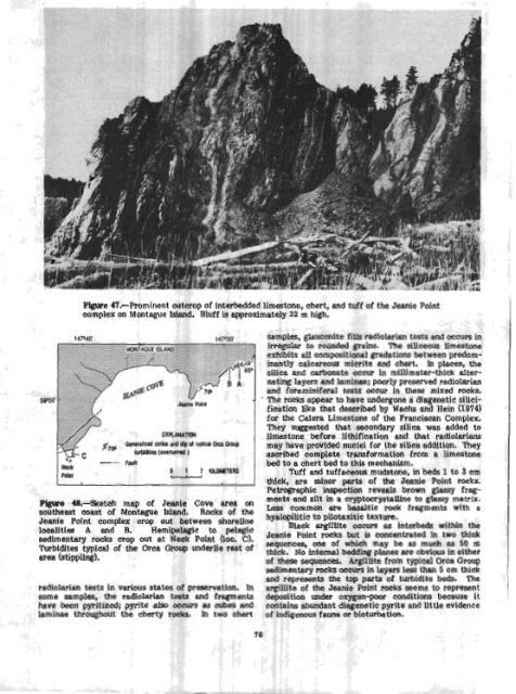
Pigure 47.-Prominent outcrop of interbedded limestone, chert, and tuff of the Jeanie Faint complex on Montague Island. Bluff is approximately 32 m high. 0 -... Nstk Fau)l 0 1 2 M U H m R S , . a I Egtm 48.-Sketch map of Jeanie Cove area on southeast mast of Montegue Island, Rocks of the Jeanie Point cornp1ex crop out between shoreline lditfes A and B. Hemipelagic to pelagic sedimentary mcks crop out at Neck Point (Ioc. C). Turbfdltes typical of the &c& Group underlie rest of area (stippling). radiolarim tests in various' states of preservation. In some mrnples, the radiolarim tests and fragments have been ppitized; pyrite &so occurs as wbes and laminae throughout the cherty rocks. In two chert samples, ghuconite fill.$ radiolarian tests and occurs in Irregular to rounded grains. The siliceous limestone exhibits all compositional gradat ions between predom- inantly calcareous micrite and chert. In places, the silica and carbonate occur in millimeter-thick alter- nating layers and laminae; poorly preserved radiolarim and foraminifera1 tests occur in these mixed rocks. ' The rocks appear to have undergone a diegenetic silici- fication like that described by Wachs and Hein (1974) for the Calera Limestone or the Franciscan Complex. They suggested that secondary silica was added to . limestone before lithif ication and that rediolarians may have provided nuclei for the silica addition. They ascribed complete transformation from a limestone bed to a chert bed to this mechanism. Tuff and tuffaeeous mudstone, in beds I to 3 em thlek, are minor parts of the Jennie Point rocks. Petrographic inspection reveals brown gLassy frag- ments and silt in a cryptocrystalline to glassy matrix. Less common are basaltic rock fragments with a hyalopifitic to pilotaxitic texture. Black argilllte occurs as interbeds within the Jeanie Point rocks but is concentrated in two thick sequences, one of which may be as much as 50 m thick. No internal bedding planes me obvious in either of these sequences. Argilltte from typical Orca Group sedimentary rocks occurs in layers less than 5 cm thick and represents the top parts of turbidite beds. The argillite of the Jeenie Point rocks seems to represent deposition under oxygen-psw conditions because it contains abundant diagenetic pyrite and llt tle evidence of indigenous fauna or bioturbation .
Thin lenses of cabonate packtone to wacks- stone wcnr sparsely throughout the Jeanie PoLnt rocks. These tocks show grading on 8 millimeter to centimeter scale and contain silt- to sand-size clasts in a micrltic matrix. ?he dasts consist of skeletal debris, angular quartz, and volcanic fragments, includ- fng glass. These calcareous rocks could be small-scale Kelts, Kmy, and Arthur, M. A, 1981, Turbidties after ten years of deep sea drilling--wringing out the mop?, jg Warrne, J. E., Douglas, R. G., and Winterer, E. L., eds., The Deep Sea Drilling hoj- ect: A decade of progress: Society of Economic Paleontologists and Minerdogis ts Special Publi- cation 32, p. 91-137. Wauhs, Daniel, and Hein, J. R., 1974, Petrography and diagenesis of Franciscan limestones: Journal of Sedimentary Petrology, v. 44, no. 4, p. 1217- 1231. Wlnkler, G. R., 1976, Deep-sea fan deposition of the lower Tertiaq Orca Qmup, eastern Prince William Sound, Alaska: U.S. Geological Survey Open-File Report 76-83, 20 p. locally derived turbidites or hemipelagic sediment r e worked by bottom currents (~elts and Arthur, 1981). Clastic rocks of a leas local provenance than thase discussed above also occur in the Jeanie Point rocks. A few thin beds of fine- to medium-grained sandstone, rich in Lithic clasts, that closely resemble tutbidites of the Orca Group on Montague Island ace interbedded with Jeanie Point carbonate rocks at two localities. Sandstone rich in lithic clasts also occurs as clastic dikes, containing as much as 20 percent sparrycalcite cement, that are found throughout the Jeanle Occurreace of the Cantwell(?) Formation wth uf the Point rocks but seem to be most abundant in the argU- Deaali fault system in the Healy qudwgle, southern Ute-rich intervals. Ah3k.S Helwig and Emmet (1~81) reported that the Jeanie Point complex is fault bounded. It is cut by By B h Csejtey, Jr, Warren E. Yeend, and David J. northeasterly trending faults that parallel the neotec- G.0erZn.I tonic faults on this part of Montague Bland, In fact, a probable fault slice of turbidite Is exposed in the tidal The Denalj fault system is one of the most conflats between the two prominent points. In places, this spicuous structural features of southern Alaska; its turbidite slice is olistostromal; irregular blocks of northward-onvex trace trends more than 1,200 km sandstone and mudstone, as much as several meters across the entire width of the State (Grmtz, 1966). across, occur in a mudstone matrix. However, the This -tern has been previously described as a major Jade Point rwks are not actually fault bounded; al- strikesup feature with possibly as much a8 several though faults are present near their borders, the hundreds of kilometers of Cenozoic ri ht-lateral offset Jeanie Point rocks lie on both sides of these faults and (for example, Forbes and others, 1978 are interbedded with the apparently typical Orca Zn more recent years, an informal but Important Gmup turbidites. This relation is most evident at the consideration in the tectonic evaluation of the DenaU northeasternmost of the two prorninent points men- fault system was the assumption that continental rocks tioned above. of the Paleocene (Wolfe and Wahrhaftig, 1970, p. A46) Our structural and lithologic data suggest that Cant well Fornia tion, which underlie large areas north the Jeanie Point rocks do not represent an exotic ter- of the McKinley fault of the Denall system near its cane or an older basement for the Orca Group. Inter- apex, are absent south of it. Earlier reports by Capps beds of Jeanie Point limestone and typlcal Orca Group (1933, 1940) of outcrops of the Cantwell Formation turbidites at the northeast margin of the complex south of the Denali fault system, in the southwestern ague agahst a fault-slice origin. Furthermore, sub- part of the Healy quadrangle, have been informally stantial intervals of pelagic to hemipelagjc rocks are discredited by many geologists. Our current reconknown elsewhere within typical Orca Group turbidites; naisaAnce geologic investigations in the Healy quedexamples include the sequences on Hawkins and Hinch- rangle (area 5, fig. 44) suggest that the Cantwen inbrook Islands (Wlnkler, 1976), at Gravina Point and Formation occurs south of the Denali fault system, as Point Martin in the Cordova quadrangle, and at Neck originally mapped by Capps. T%is occurrence south of Point on Montague Island, just 9 km southwest of the McKinley fault (fig. 49) is b8sed on plant-fossil Jeanie Point (loc. C, fig. 48). evidence and on the lithologic and sbatigraphic simi- These occurrences negate the uniqueness of the larltles of these rocks to the typical Cantwell north of Jeanle Point rocks within the Orca Group. The hemi- the fault. pelagic composltton of the rocks suggests that bey The proposed correlation lends credence to the were deposited in a slope environment in a small, re- tectonic interpretation that no more than about 10 km stricted basin. Winkler (1976) suggested that the fine- of Cenozoic right-lateral offset has occurred along the grained carbonate rocks of Hinchhbrook Island were central section of the Denali fault system In Alaska deposited in the shadow of local volcanlc barriers. (Csejtey and others, 1982). TBis interpretation of lim- Tempornry volcanic barriers may have provided pro- ited right-lateral Cenozoic offset is based on the I tection from the Influx of terrigenous sediment and occurrence of the same Piassic and Lower Cretaceous I allowed the Jeenie Point sediment to accumulate. units on both sides of the McKinley fault, and on the continuity of a belt of Upper Cretaceous metamorphic REPERENCES CITED rocks that extends across the DenaU fault system in the eastern part of the Heaiy quadrangle (Pig. 49; I Helwig, James, and Emmet, Peter,, 1981, Structure of Csejtey md others, 1982). Here, we brlefly descrlbe the Early Tertiary Orca Group in Prince WUam the probable CantweU Formation south of the Denall Sound and some implications for the plate tec- fault and, for comparison, some of the Cantwell strata tonic history of southern Alaska: Alaska Ceolog- to the north. Pigure 49 shows the localities of the ical Society Journal, v. 1, p. 12-55. described stratigraphic sections and rook samples.
- Page 35 and 36: 3 EUMN OF MAP UNITS WAmWARY OUAERNA
- Page 37 and 38: -om displacement of the cc tween th
- Page 39 and 40: I US I Surlicial dcnrrua,ts [~dater
- Page 41 and 42: I Plafker, George, Hudson, Travis,
- Page 43 and 44: !omlensed iring vapors generated by
- Page 45 and 46: and the thinning. -upward cycles .,
- Page 47 and 48: Kellum, L. B., Devless, S. N., and
- Page 49 and 50: 1912 sample (a mediumwey pumice blo
- Page 51 and 52: various Utholagic units present Thu
- Page 53 and 54: fault, and Its depositional basemen
- Page 55 and 56: suggested by coplanar foUaticm and
- Page 57 and 58: 1 slgnlficarrtly more umnlum (73&1,
- Page 59 and 60: ecrSigtallized catadastic matrix of
- Page 61 and 62: analyzed to determine whether Immob
- Page 63 and 64: are tgplcd of both ocean-floor basa
- Page 65 and 66: & Fclsic in~rutirt rucks 0 Eio~ite
- Page 67 and 68: are Lrdlcated by coexisting @&ite+q
- Page 69 and 70: (Mg3.09 pe2+ 0.69 pe 0.~1~0.01~~0.9
- Page 71 and 72: westward into a narrow band that ex
- Page 73 and 74: EXF'lANATIOW 66600' Contan-Apprnimn
- Page 75 and 76: ! few fold closures are preserved.
- Page 77 and 78: even thickness and conform to irreg
- Page 79 and 80: (Alnus ap.), heaths (Ericaceae, + E
- Page 81 and 82: terrane extends at least 300 krn to
- Page 83 and 84: Table 19.--6tneral petrography of M
- Page 85: were measured on 8 12-in. mass spec
- Page 89 and 90: The cantwell(?) Pormation south of
- Page 91 and 92: in the 18 lava flows b thermoremane
- Page 93 and 94: Upper Cretaceous shale in contact w
- Page 95 and 96: Gran tz, Arthur, 1960, Generalized
- Page 97 and 98: at 15 to 20 percent. Primary Inolus
- Page 99 and 100: addition, this factor generally def
- Page 101 and 102: Joreskog, K. G., Klovan, J. E., and
- Page 103 and 104: Mineral qItWation end r ~ k t k W e
- Page 105 and 106: 1 "~_liO-/ 200 1000 B roo C E % A B
- Page 107 and 108: Smaller placer mines ere active on
- Page 109 and 110: Figme 62.-Plant fassils from the co
- Page 111 and 112: Hallam, Anthony, 1975, Alfred Wegen
- Page 113 and 114: u ALASKA Figure 65.--Sketch map of
- Page 115 and 116: F ' i a?.-Intertidal bluffs compose
- Page 117 and 118: C-s - - Figure 70.-Products of eros
- Page 119 and 120: curve is based indicates that 6.1 c
- Page 121 and 122: sampled is related to widespread ma
- Page 123 and 124: marble is alsa locally present In t
- Page 125 and 126: Bedding in the conglomerate ranges
- Page 127 and 128: 1 purpose of this study wes to dete
- Page 129 and 130: The secona k~~-~ri?tation mmes that
- Page 131 and 132: epizonb'l granitic Miss, mixed with
- Page 133 and 134: 40 40 Forbes, R. B., and Engels, J.
- Page 135 and 136: foliated and inequigranular end con
Pigure 47.-Prominent outcrop <strong>of</strong> interbedded limestone, chert, and tuff <strong>of</strong> the Jeanie Faint<br />
complex on Montague Island. Bluff is approximately 32 m high.<br />
0 -...<br />
Nstk<br />
Fau)l<br />
0 1 2 M U H m R S<br />
, . a I<br />
Egtm 48.-Sketch map <strong>of</strong> Jeanie Cove area on<br />
southeast mast <strong>of</strong> Montegue Island, Rocks <strong>of</strong> the<br />
Jeanie Point cornp1ex crop out between shoreline<br />
lditfes A and B. Hemipelagic to pelagic<br />
sedimentary mcks crop out at Neck Point (Ioc. C).<br />
Turbfdltes typical <strong>of</strong> the &c& Group underlie rest <strong>of</strong><br />
area (stippling).<br />
radiolarim tests in various' states <strong>of</strong> preservation. In<br />
some mrnples, the radiolarim tests and fragments<br />
have been ppitized; pyrite &so occurs as wbes and<br />
laminae throughout the cherty rocks. In two chert<br />
samples, ghuconite fill.$ radiolarian tests and occurs in<br />
Irregular to rounded grains. The siliceous limestone<br />
exhibits all compositional gradat ions between predom-<br />
inantly calcareous micrite and chert. In places, the<br />
silica and carbonate occur in millimeter-thick alter-<br />
nating layers and laminae; poorly preserved radiolarim<br />
and foraminifera1 tests occur in these mixed rocks.<br />
' The rocks appear to have undergone a diegenetic silici-<br />
fication like that described by Wachs and Hein (1974)<br />
for the Calera Limestone or the Franciscan Complex.<br />
They suggested that secondary silica was added to<br />
. limestone before lithif ication and that rediolarians<br />
may have provided nuclei for the silica addition. They<br />
ascribed complete transformation from a limestone<br />
bed to a chert bed to this mechanism.<br />
Tuff and tuffaeeous mudstone, in beds I to 3 em<br />
thlek, are minor parts <strong>of</strong> the Jennie Point rocks.<br />
Petrographic inspection reveals brown gLassy frag-<br />
ments and silt in a cryptocrystalline to glassy matrix.<br />
Less common are basaltic rock fragments with a<br />
hyalopifitic to pilotaxitic texture.<br />
Black argilllte occurs as interbeds within the<br />
Jeanie Point rocks but is concentrated in two thick<br />
sequences, one <strong>of</strong> which may be as much as 50 m<br />
thick. No internal bedding planes me obvious in either<br />
<strong>of</strong> these sequences. Argilltte from typical Orca Group<br />
sedimentary rocks occurs in layers less than 5 cm thick<br />
and represents the top parts <strong>of</strong> turbidite beds. The<br />
argillite <strong>of</strong> the Jeenie Point rocks seems to represent<br />
deposition under oxygen-psw conditions because it<br />
contains abundant diagenetic pyrite and llt tle evidence<br />
<strong>of</strong> indigenous fauna or bioturbation .


