n Alas - Alaska Division of Geological & Geophysical Surveys - State ...
n Alas - Alaska Division of Geological & Geophysical Surveys - State ... n Alas - Alaska Division of Geological & Geophysical Surveys - State ...
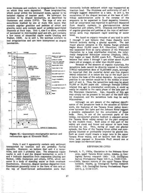
Holes as much as 5 m deep within the weathered conglomerate have been dug by the miners, but the presence of large volumes of subsurface water makes mining difficult at this depth. One local miner stated that an early-day miner sank a shaft 25 m In the Ter- tiary(?) conglomerate wlthout reaching its base. The conglomerate is truncated by a fault (Hot Springs fault?) near Crooked Creek. Orange-brown clayey weathered (Tertiary?) con- glomerate is exprsed at the base of a backhoe trench excavated in the fan grovel of Deadwood Creek. Here, the Tertiary(?) conglomerate is overlain by about 2 m of silty gray-brown gold-bearing fan gravel. Clasts in the orangedrown material are generally 5 cm in diam- eter or smaller, composed of 90 to 95 percent weathered quartzite and schist and 5 to 10 percent quartz. A total of 12 gold "colorsn were panned from a sample collected at the contact of the gray gravel with the underlying orange+rown conglomerate, and 2 l'colorsT1 were panned from the weathered conglom- erate itself approximately 48 cm below this contact. Although Tertiary(?) clastic mcks in the Circle quadrangle appear to be restricted to the Tintina fault zone, when Initially deposited they probably covered arms beyond the fault zone. If so, these rocks most likely were a source for much of the gold occurring in the Holocene alluvium that has supplied the Circle dis- trlct placer miners with a gold resource for more than 80 yem. REFERENCES CITED Mertie, J. B., Jr., 1938, Gold placers of the Fortymile, Eagle, and Circle districts, Alaska: U.S. Geo- logical Survey Bulletin 8974, p. 133-261. Weber, F. R., and Foster, H. L., 1982, Tertiary(?) con- glomerate and Quaternary faulting in the Circle quadrangle, Alaska, Coonrad, W. L., ed., The United States Geological Survey in Alaska: Accomplishments during 1980: U.S. Geological Survey Circular 844, p. 58-61. Leeusrrime and eolian deposits of Wiscoasin age at Bivhde W f in the rpper Tanane Ever valley, Alaska By L. David Carter and John P. Galloway Riverside Bluff (loe. 4, Pig. 231, a 40-m-high cutbank on the nottheast side of the Tanana River near Riverside Lodge, about 50 km southeast of Tok (Tanacross A-3 quadrangle, let 6 3O0913 8" N., long 142°0612511 W.), is one of the few readily accessible localities in this area at which Quaternary deposits are both thick and well exposed. Part of the bluff was described by Fernald (1965a), but he did not identify lacustrine beds nnd could not directly date eolim deposits in the section. Here, we present two radiocarbon dates for the eolian part of the section as well as eviderlce that some of the bluff deposits are lacustrine in origin, and comment on the possible significance of these lacustrine beds to the late Quaternary history of the upper Tanma Valley. The part of the bluff in which Quaternary deposits are well exposed extends from Bitters Creek downstream about 1.5 km. Fernald (1965~1) described the bluff materials near Bitters Creek es consisting of 4.5 m of compacted sand, silt, artd muck that is unconformably overlain by 24 m of fluvial sand and silt and some fine to coarse rubble. Overlying this fluvial material is 6 m of eolian sand, above which is as much as 6 m of alluvial-colluvial sand, silt, organic material, and fine rubble. Pernald (1965a, p. ~122) reported radibctlrbon eges of 1,520 to 6,200 years for the uppermost alluvial-colluviel materials, of 25,800 years in the upper part of the fluvfd deposits, and of greater than 42,000 years on wood from the basal sand, silt, and muck. Fernald (1965a) proposed that the basal unit was deposited during the last or Sangamon Interglaciation and correlated the fluvial and overlying eolian deposits with the deposits of the Jatahmund Lake Glaciation, which he presumed to be equivalent to the entire Wisconsinan Stage. He equated the 25,800 year age to e Wisconsjnan interstadid. We examined the bluff about 1.25 km downstream Prom Bitters Creek, near where a small unnanred stream enters the 'Panana River. Here, the silty sand to sandy silt that makes up the bluff deposits can be divided into 11 units on the basis of sedimentary structures (fig. 41). We correlate unit I with Pernald's (1965~) basal unit and agree that it is most llkely of last interglacial age. Units 2 through 5 are probably equivalent to his overlying "fluvial" deposits, but we believe that a significant part of the deposits which we examlned are lecustrine in origin. We correlate units 6 through 9 with Fernald's eolian deposits, and unit 10 with the elluvial-colluvial upper part of his section. The volcanic ash beneath the modern turf is probably the White River tkh Bed (Phd, 19751, a widespread member of the Engineer Loess in east-central Alaska and the adjacent Yukon Territory that is about 1,400 years old. The eolian part of the section b about 10 m thick and conslsts of dune supface deposits with lqe-scde high-angle cross-stratification (units 7, 9) and of inter dune-pond deposits composed of laminated silty sand (units 6, 8). Radiocarbon ages of 12,230f 120 years (USGS-1037) md 11,BBOf 100 years (I-11,704), determined on plant remains collected from the pond deposits, Lndicate that the eolian beds are Late Wisconsinan, as Pernald (1965a) suggested, and agree well with radioctlrbon ages of 12,400, 11,250, and 8,200 years obtained by Pecneld (1965b) on organic materials associated with stabilized eolian sand at nearby localities in the upper Tanana Valley. Bedding nttitudes in the dune-slipface deposits of El. 22' E., 27' SE., in unit 7 and of N. 17' E., 30' Sl?., in unit 9 indicate upvalley dune migration, as do the slipfacc orientations of stabilized dunes on top of the bluff and elsewhere in the upper Tanana Valley. Our contention that laeustrlne beds are present below the eolian deposits is based on sediment composition and structure. Units 2 and 5, which are 9 and 1.5 rn thick, respectively, consist of silty sand containing angular granules and pebbles of locally derived schist and granite. Beds are a few centimeters to about 10 cm thick and exhibit tabular crossbedding, trough crossbedding, lenticular bedding, md minor horizontal bedding. Unit 3, which is 6 m thick, consists of sets that are each about 1 m thick. Each set generally contains a lower zone of laminated sand and silt as much as 0.5 rn thick, and an upper zone of silty sand with tabular crossbedding. The laminee are of
even thickness and conform to irregularities in the bed on which they were deposited. These irregularities, which occur within the lsminatd zones, appear to be isolated ripples of coarser sand. We interpret the lamin~e to be draped lamination, 8s described by Gustavson and others (1975). The tops of sets are sometimes marked by one or more thin layers that contain angular granules and pebbles of schist and granite; some sets contain sand- or pebblyad-filled channels at their taps. Unit 4, also 6 m thick, consfsts of laminated to thin+edded sand and silt, and contains a few zones of sinusoidal ripple marks (Jopling and Walker, 1968). As in unit 3, the laminae conform to bed irregulrvities and are here interpreted as draped Lamination. Figme 4l.-Quaternary stratipaphic section and radiocarbon ages at Riverside Bluff. Units 2 and 5 apparently contain only sediment transported by traction and are probably fluvial deposits. However, we believe that unit 4 is lacus- trine, and unit 3 probably also. The sinusoidal ripple marks in unit 4 and the draped lamination in units 3 and 4 Indicate deposition from suspension (JopUng and Walker, 1968; Gustavson md others, 1975), which can occur in a body of standing water or from overbank floodwaters. However, draped Iaminae deposited from floodwaters generally occur in the form of thin sets at the top of flood-formed sedimentation units that commonly include seclirnent wMch was transported as traction load. The thickness and uniformity of unit 4 strongly suggest deposition in a lake. h unit 3, the occurrence of the draped laminae at the base of indi- vidual sedimentation units b the reversa of the sequence to be expected In flood deposits; however, such an occurrence was reported In sediment deposited from density currents In glaciolacustrine deltas (Gustavson and others, 1975). Channels and thln layers of angular granules and pebbles at the tops of sedimen- tation units may represent rapid lowering of water level. We found no organic remains of any kind In units 2 through 5 and believe that these deposits were formed entirely during a glaclal episode. The lasi major glacial advance in the Alaska Range probably began about 25,000 years B.P. (Hamilton, 1982) end was separated from en early advance of the Wisconsin Glaciation by a long interstadid interval, the infor- mally designated Boutelher interval (Hopkins, 19831, that began at.1-t 49,000 years B.P. Therefore, we believe that units 2 through 5 are either about 25,000 years old or younger, or older than 49,000 years. Because of the absence of organic materlds, the lacustrine beds cannot be directly related to Pernald's (19654 radiocmbon date of 25,800*00 years, although he reported that the materlal dated was fine organic debris collected 14 m below the top of the bluff and 6 rn below the bese of the eolian deposits. An equivalent position In our section would be in the middle or lower part of unit 4. Thus, the lacustrine beds may be about 25,000 or 26,000 years old. Although Fernald (1965a) related this age to interstadia1 conditions, it could as easily be related to the early phase of the late part of the Wisconsin Glaciation. Also, deposits of this age may simply not be present in the part of the bluff that we measured, and the lacuatdne beds may be early W isconsinan. Although we are unsure of the reglonal slgrufi- cmce of the lecustrine beds in the absence of further work, the features of the Tanana River vdley down- river between Dot Lake and the Johnson River suggest e possible explanation for the occurrence of these beds. Here, in one of the narrowest parts of the valley, ice-scoured granitic bedrock is exposed across the Tanana River valley except for the part occupied by the modern river. Both sides of this part of the valley are steep and linear and appear to have been trimmed by ice. Thus, during at least one glacial episode, the flow of the Tanana River either was com- pletely blocked or profoundly impeded by glacial ice. Such an event could create a large lake in the upper Tanana Rtver vaUey, and we believe that the lacus- trhe beds exposed in Rivecside Bluff record one or more large ice-dam med lakes. BWERBNC BS CITED Pernald, A. T., 1965a, Glaciation in the Nabesna River area, uppel. Tanana River valley, Alaska, Geo- logical Survey research 1965: U.S. Geological Survey Professional Paper 525-C, p. C120-Cl23. -1965b, Recent history of the upper Tanana River lowlnd, Alaska, ~ Geological Survey research 1965: U.S. Geological Survey Professional Paper 525-C, p. C124-C127.
- Page 25 and 26: I (Nilsen and others, 1981a); (2) f
- Page 27 and 28: I that contains the Upper Devonian
- Page 29 and 30: who found Westeqaardodina sp., posb
- Page 31 and 32: Table 2 lists the means rtnd for th
- Page 33 and 34: ' Noatak Vdley (fig. 129. This ice
- Page 35 and 36: 3 EUMN OF MAP UNITS WAmWARY OUAERNA
- Page 37 and 38: -om displacement of the cc tween th
- Page 39 and 40: I US I Surlicial dcnrrua,ts [~dater
- Page 41 and 42: I Plafker, George, Hudson, Travis,
- Page 43 and 44: !omlensed iring vapors generated by
- Page 45 and 46: and the thinning. -upward cycles .,
- Page 47 and 48: Kellum, L. B., Devless, S. N., and
- Page 49 and 50: 1912 sample (a mediumwey pumice blo
- Page 51 and 52: various Utholagic units present Thu
- Page 53 and 54: fault, and Its depositional basemen
- Page 55 and 56: suggested by coplanar foUaticm and
- Page 57 and 58: 1 slgnlficarrtly more umnlum (73&1,
- Page 59 and 60: ecrSigtallized catadastic matrix of
- Page 61 and 62: analyzed to determine whether Immob
- Page 63 and 64: are tgplcd of both ocean-floor basa
- Page 65 and 66: & Fclsic in~rutirt rucks 0 Eio~ite
- Page 67 and 68: are Lrdlcated by coexisting @&ite+q
- Page 69 and 70: (Mg3.09 pe2+ 0.69 pe 0.~1~0.01~~0.9
- Page 71 and 72: westward into a narrow band that ex
- Page 73 and 74: EXF'lANATIOW 66600' Contan-Apprnimn
- Page 75: ! few fold closures are preserved.
- Page 79 and 80: (Alnus ap.), heaths (Ericaceae, + E
- Page 81 and 82: terrane extends at least 300 krn to
- Page 83 and 84: Table 19.--6tneral petrography of M
- Page 85 and 86: were measured on 8 12-in. mass spec
- Page 87 and 88: Thin lenses of cabonate packtone to
- Page 89 and 90: The cantwell(?) Pormation south of
- Page 91 and 92: in the 18 lava flows b thermoremane
- Page 93 and 94: Upper Cretaceous shale in contact w
- Page 95 and 96: Gran tz, Arthur, 1960, Generalized
- Page 97 and 98: at 15 to 20 percent. Primary Inolus
- Page 99 and 100: addition, this factor generally def
- Page 101 and 102: Joreskog, K. G., Klovan, J. E., and
- Page 103 and 104: Mineral qItWation end r ~ k t k W e
- Page 105 and 106: 1 "~_liO-/ 200 1000 B roo C E % A B
- Page 107 and 108: Smaller placer mines ere active on
- Page 109 and 110: Figme 62.-Plant fassils from the co
- Page 111 and 112: Hallam, Anthony, 1975, Alfred Wegen
- Page 113 and 114: u ALASKA Figure 65.--Sketch map of
- Page 115 and 116: F ' i a?.-Intertidal bluffs compose
- Page 117 and 118: C-s - - Figure 70.-Products of eros
- Page 119 and 120: curve is based indicates that 6.1 c
- Page 121 and 122: sampled is related to widespread ma
- Page 123 and 124: marble is alsa locally present In t
- Page 125 and 126: Bedding in the conglomerate ranges
even thickness and conform to irregularities in the bed<br />
on which they were deposited. These irregularities,<br />
which occur within the lsminatd zones, appear to be<br />
isolated ripples <strong>of</strong> coarser sand. We interpret the<br />
lamin~e to be draped lamination, 8s described by<br />
Gustavson and others (1975). The tops <strong>of</strong> sets are<br />
sometimes marked by one or more thin layers that<br />
contain angular granules and pebbles <strong>of</strong> schist and<br />
granite; some sets contain sand- or pebblyad-filled<br />
channels at their taps. Unit 4, also 6 m thick, consfsts<br />
<strong>of</strong> laminated to thin+edded sand and silt, and contains<br />
a few zones <strong>of</strong> sinusoidal ripple marks (Jopling and<br />
Walker, 1968). As in unit 3, the laminae conform to<br />
bed irregulrvities and are here interpreted as draped<br />
Lamination.<br />
Figme 4l.-Quaternary stratipaphic section and<br />
radiocarbon ages at Riverside Bluff.<br />
Units 2 and 5 apparently contain only sediment<br />
transported by traction and are probably fluvial<br />
deposits. However, we believe that unit 4 is lacus-<br />
trine, and unit 3 probably also. The sinusoidal ripple<br />
marks in unit 4 and the draped lamination in units 3<br />
and 4 Indicate deposition from suspension (JopUng and<br />
Walker, 1968; Gustavson md others, 1975), which can<br />
occur in a body <strong>of</strong> standing water or from overbank<br />
floodwaters. However, draped Iaminae deposited from<br />
floodwaters generally occur in the form <strong>of</strong> thin sets at<br />
the top <strong>of</strong> flood-formed sedimentation units that<br />
commonly include seclirnent wMch was transported as<br />
traction load. The thickness and uniformity <strong>of</strong> unit 4<br />
strongly suggest deposition in a lake. h unit 3, the<br />
occurrence <strong>of</strong> the draped laminae at the base <strong>of</strong> indi-<br />
vidual sedimentation units b the reversa <strong>of</strong> the<br />
sequence to be expected In flood deposits; however,<br />
such an occurrence was reported In sediment deposited<br />
from density currents In glaciolacustrine deltas<br />
(Gustavson and others, 1975). Channels and thln layers<br />
<strong>of</strong> angular granules and pebbles at the tops <strong>of</strong> sedimen-<br />
tation units may represent rapid lowering <strong>of</strong> water<br />
level. We found no organic remains <strong>of</strong> any kind In units<br />
2 through 5 and believe that these deposits were<br />
formed entirely during a glaclal episode. The lasi<br />
major glacial advance in the <strong>Alas</strong>ka Range probably<br />
began about 25,000 years B.P. (Hamilton, 1982) end<br />
was separated from en early advance <strong>of</strong> the Wisconsin<br />
Glaciation by a long interstadid interval, the infor-<br />
mally designated Boutelher interval (Hopkins, 19831,<br />
that began at.1-t 49,000 years B.P. Therefore, we<br />
believe that units 2 through 5 are either about 25,000<br />
years old or younger, or older than 49,000 years.<br />
Because <strong>of</strong> the absence <strong>of</strong> organic materlds, the<br />
lacustrine beds cannot be directly related to Pernald's<br />
(19654 radiocmbon date <strong>of</strong> 25,800*00 years, although<br />
he reported that the materlal dated was fine organic<br />
debris collected 14 m below the top <strong>of</strong> the bluff and 6<br />
rn below the bese <strong>of</strong> the eolian deposits. An equivalent<br />
position In our section would be in the middle or lower<br />
part <strong>of</strong> unit 4. Thus, the lacustrine beds may be about<br />
25,000 or 26,000 years old. Although Fernald (1965a)<br />
related this age to interstadia1 conditions, it could as<br />
easily be related to the early phase <strong>of</strong> the late part <strong>of</strong><br />
the Wisconsin Glaciation. Also, deposits <strong>of</strong> this age<br />
may simply not be present in the part <strong>of</strong> the bluff that<br />
we measured, and the lacuatdne beds may be early<br />
W isconsinan.<br />
Although we are unsure <strong>of</strong> the reglonal slgrufi-<br />
cmce <strong>of</strong> the lecustrine beds in the absence <strong>of</strong> further<br />
work, the features <strong>of</strong> the Tanana River vdley down-<br />
river between Dot Lake and the Johnson River suggest<br />
e possible explanation for the occurrence <strong>of</strong> these<br />
beds. Here, in one <strong>of</strong> the narrowest parts <strong>of</strong> the<br />
valley, ice-scoured granitic bedrock is exposed across<br />
the Tanana River valley except for the part occupied<br />
by the modern river. Both sides <strong>of</strong> this part <strong>of</strong> the<br />
valley are steep and linear and appear to have been<br />
trimmed by ice. Thus, during at least one glacial<br />
episode, the flow <strong>of</strong> the Tanana River either was com-<br />
pletely blocked or pr<strong>of</strong>oundly impeded by glacial ice.<br />
Such an event could create a large lake in the upper<br />
Tanana Rtver vaUey, and we believe that the lacus-<br />
trhe beds exposed in Rivecside Bluff record one or<br />
more large ice-dam med lakes.<br />
BWERBNC BS CITED<br />
Pernald, A. T., 1965a, Glaciation in the Nabesna River<br />
area, uppel. Tanana River valley, <strong>Alas</strong>ka, Geo-<br />
logical Survey research 1965: U.S. <strong>Geological</strong><br />
Survey Pr<strong>of</strong>essional Paper 525-C, p. C120-Cl23.<br />
-1965b, Recent history <strong>of</strong> the upper Tanana River<br />
lowlnd, <strong>Alas</strong>ka, ~ <strong>Geological</strong> Survey research<br />
1965: U.S. <strong>Geological</strong> Survey Pr<strong>of</strong>essional Paper<br />
525-C, p. C124-C127.


