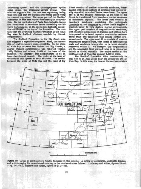
analyses, might determin r the Au and Ag con- tents <strong>of</strong> the oxidized zone are considerably above the crustaI averages, which would indicate mineralization within the system. Such analyses have not yet been made. SUMMARY Several features charaeterlstic <strong>of</strong> hotspring and stockwork gold deposits occur at Sunrise dome in the Nowitna River area, including silicification, argillic alteration, hydrothermal brecciation, significant trace-metal anomaUes in Hg, As, and Sb, and high con- centration <strong>of</strong> iron oxides, probably from the weather- tng <strong>of</strong> sulfldes (Berger and Tingley, 1980; Wallace, 1980; M. L. Silberman, unpub. data, 1981). The geometry <strong>of</strong> the hydrothermal system is not known, although the features present suggest it to be very shallow. Although no detectable (at the limits <strong>of</strong> the analytical techniques used) gold or silver are present at the surface, it may be that supergene and (or) hypogene leaching has resulted In their enrichment at depth. It may a h be that mineralization was limited to deeper parts <strong>of</strong> the system, possibly within a densely silicified and (or) stockwork zone, as is common in many deposjts <strong>of</strong> me tme described. . - NCES cr igneous KI~U lrretainorphic cocks <strong>of</strong> the Me quadrangle, <strong>Alas</strong>ka: U.S. <strong>Geological</strong> Su Open-Pile Report 80-811-C, 19 p. Patton, W. W., Jr., Moll, E. J., Dutro, J. T., Jr., berman, M. L., and Chapman, R M., 1980, lirninary geologic map <strong>of</strong> the Medfra quadrru,,,, <strong>Alas</strong>ka: U.S. <strong>Geological</strong> Survey Open-Pile Report 80-81 1-A, scale 1:250,000. Radtke, A. S., Rye, R. O., and Dickson, F. W., 1980, Geology and stable isotope studies <strong>of</strong> the Carlin gold deposit, Nevada: Economic Geology, v. 75, no. 5, p. 641-672. Wallace, A. B., 1980, Geology <strong>of</strong> the Sulphur district, southwestern Humboldt County, Nevada: Society <strong>of</strong> Economic Geologists Field Conference, Reno, 1980, Road Log and Articies, p. 80-91. SO-RN ALASKA (Figure 19 shows study arm discussed) Newly meognhd dimentmy envimnmeuts Ln the SheWt<strong>of</strong> Formation, Blaslca By WilZLam 8. BUaway, Jr, and John W. Muel The Shelik<strong>of</strong> Formation was named by Capps (1922) for the rocks that form most <strong>of</strong> the bold heacth. Berger, B. R., and Tinglt,, .,. v V . ., 1980, Geochemistry lands along the northwest shore <strong>of</strong> Shelik<strong>of</strong> Strait be<strong>of</strong> the Round Mountain gold deposit, Nye Co., tween Katmai Bay and the southwest end <strong>of</strong> Wide Nevada [abs.]: Society <strong>of</strong> Mining Engineers <strong>of</strong> Bay. During summer 1981, a stratipaphie study <strong>of</strong> the AIME, Northern Nevada Section Precious Metals Shelik<strong>of</strong> Formation was conducted as part <strong>of</strong> the <strong>Alas</strong>- Symposium, Reno, Nev., Abstracts, p. 18c. kan Mineral Resource llssessment Program (AMRAP), Boyle, R W., 1979, The geochemistry <strong>of</strong> gold and its Ugashik and Karluk quadrangles. The areas investideposits: <strong>Geological</strong> Survey <strong>of</strong> Canada Bulletin gated (area 1, fig. 19; fig. 20) included the peninsula 280, 584 p. between Puale and Mnchak Bays, an area near the Buchanan, L. J., 1981, Precious metal deposits associ- head <strong>of</strong> Big Creek (north end <strong>of</strong> Wide Bay), and the ated with volcanlc environments In t' he sout h- ridge southwest <strong>of</strong> Ahi Creek (south end <strong>of</strong> Wide Bay). west: Arizona <strong>Geological</strong> Society Dig€ !st, V. 1 4, Environmental interpretations <strong>of</strong> the Shelik<strong>of</strong> p. 237-262. Formation in the literature are few. On the basis <strong>of</strong> Kessler, S. E., Russell, N., Seaword, M., Rav=~a, J., ammonite assemblages, Imlag (1953; oral communs., McCurdy, K., Cumming, G. L., and Sutter, J. F., 1979, 1980) interpreted the Shelik<strong>of</strong> Fopmation to have 1981, Geology and geochemistry <strong>of</strong> sulfide been deposited on a steep slope fronting an open minerallzatfon underlying the Pueblo Vieja gold- ocean. Burk (1965) suggested a deep neritic environsilver deposit, Dominican RepubLic: Economic ment for the Shelik<strong>of</strong>. Other early workers (Capps, Geology, v. 76, no. 5, p. 1096-1117. 1922; Martin, 1926; Smith, 1926; Kellum and others, Kimbech, F. W., Cruzon, M. G., md Brooks, I€. A., 1945) reported marine molluscan toss% but otherwise 1981, Geology <strong>of</strong> stockwork gold deposits as made no environmentd interpretations <strong>of</strong> the exemplified by the Cinola deposit: Denver, Shelik<strong>of</strong>. Recent work on radiolarians collected from Colorado Mining hssociation, Mining Year Bo ok a lir nestone lens in the middle <strong>of</strong> the SheIik<strong>of</strong> Porma- 1981, p. 122-129. t ion at Puale Bay shows hat this part <strong>of</strong> the section Hudson, D. M., 1977, Geology and alteration <strong>of</strong> tl he was deposited in a deep basinal environment (C. D. Wedekind and part <strong>of</strong> the Peavine districi ts, Blor ne, oral commun., 1981). Washoe Caunty, Nevada: Reno, University <strong>of</strong> Our investigations indicate that the Shelik<strong>of</strong> Nevada, M. Se. thesis, 103 p. Formation not only consists <strong>of</strong> marine facies but nlso Meyer, Chnrles, and Hemley, J. J., 1967, W d rock Is locally nonmarine (see stratigraphic section in fig. alteration, in Barnos, H. L., ed., Geochemistry <strong>of</strong> 21). The rocks in the lower part <strong>of</strong> the section at hydrothermal ore deposits: New York, Holt, hale Bay were almost entirely deposited in a fairly Rinehart and Winston, p. 167-235. deep shelf submarine-fan environment. The sandstone Parker, R. L., 1967, Cornpasftion <strong>of</strong> the E~UI's crust, units consist mainly <strong>of</strong> turbidites <strong>of</strong> facies B (Mutti chap. D <strong>of</strong> Pleischer, Michael, ed., Data <strong>of</strong> geo- and Ricci Lucci, 1972) and some <strong>of</strong> facies A and C; the chemistra6th ed.): U.S. <strong>Geological</strong> Survey Pro- interbedded siltstone is mainly <strong>of</strong> facies E and G. This fessional Paper 44043, p. Dl-D19. sequence is interpreted to represent an hnerfen to Moll, E. J., Silberman, M. L., and Patton, W. W., Jr., mid-fan sequence. Although several thiiing-upward 1981, Chemistry, mineralogy, and K-Ar ages <strong>of</strong> cycles occur within the section, the overall trend is
and the thinning. -upward cycles .,.1-1---:-- . .--.-.----I cur auove rrlr: r~~~r.ne~ur~-uywlrru cycles. This lation suggests that the sea was regressing during at time and that the depositional cycles ended owing channel migration. Thc upper pmt <strong>of</strong> the Shelik<strong>of</strong> CCI ~rm ation in this area varies considerably in compositic jn. On the north shore <strong>of</strong> Puale Bay, turbidite facies arc e transitional to nearshore facies containing the bivalve Corbicula sp.; on the south side, turbidite deposi- +iqn continued to the top <strong>of</strong> the formation. The conct with the overlying Naknek Formation Ln the Puale y area is Shelik<strong>of</strong> siltstone overlain by Naknek nglomerate. The Shelik<strong>of</strong> Formation in the Big Creek area also suggests a regressive sequence. Here, the succession <strong>of</strong> environments is more complete. On the shore <strong>of</strong> Wide Bay between Des Moines and Big Creeks, a coarse channel conglomerate was reported (~apps, 1922; KeUum and others, 1945) at the base <strong>of</strong> the Shellk<strong>of</strong>. We interpret this conglomerate to be an inner-fanehamel deposit. The rocks at the base <strong>of</strong> the section thin upward to shelf siltstone. The section tween the shore <strong>of</strong> Wide Bay and the head <strong>of</strong> Big Creek canslsts or shallow s abnerltlc sandston e, inter -.-a:-* , .-^ ---I- bedded with thick sacrrolm <strong>of</strong> siltstone that were ~FUUably deposited on a shelf below wave ! base. T he upper 460 m <strong>of</strong> the Shelik<strong>of</strong> Formation a' t the hea d <strong>of</strong> Big Creek is transitional from nearshore marine andstone ..nr+ nr. to nonmarine deposits. The lower ~~nsists <strong>of</strong> nearshore sandstone contairung the pelecypods Corbicula sp. and Gryphaea sp.; these fossils suggest a brackish-water to very shallow marine environment. The upper part consists <strong>of</strong> magnetite-rich sandstone, with inclined laminations <strong>of</strong> granules and pebbles here interpreted to be beach deposits, overlain by carbnaceous shale and sandstone that locally contain preserved roots. The uppermost 60 m consists <strong>of</strong> massive channelized conglomerate, with lenses <strong>of</strong> carbonaceous shale and sandstone interpreted to be levee deposits preserved within it. We interpret this conglomerate and the associated finer pained rocks to be nonmarine delteic or fluvial deposits. The entire section at the northesat end <strong>of</strong> Wide Bay is about 1,500 m thick. The Shellkoi Formation thins considerably to only 820 m at Alai Creek near the southwest end <strong>of</strong> Wide Bay. In this area, the base <strong>of</strong> the section consists -Areas in south wes tern <strong>Alas</strong> :ka discussed in this volume. A tistil ~g <strong>of</strong> autt iorshlp, applicable paging (in I parenthe ses) rela! king to the numbered tiweas follows. 1 , AU~wey 1 and Miller, fi we! 1; 2, Hild~ reth and c bthers, fig :ure 22 (g. 37-39). figures, i 20 and
- Page 1 and 2: n Alas Accompli: ' I.S. GE OLOGI CA
- Page 3 and 4: I CONTENTS Page A bst raet ........
- Page 5 and 6: -- --A I ALASEU i nued rral expluru
- Page 7 and 8: ........ igure .JB. ;5~ercn map ox
- Page 9 and 10: . , ".,k a. ,.e ,\a 1 y U11 IIIUUII
- Page 11: THE UNITED STATES GEOLOGICAL SURVEY
- Page 15 and 16: ~ t I r n t S i m ~ ~ Alarr a ~ man
- Page 17 and 18: I -1977, RelImlnary documentat!on l
- Page 19 and 20: I I MaCenn, W. R., Perez, 0. J., an
- Page 21 and 22: were deslgned to impMve the accurac
- Page 23 and 24: Noatak Sandstom and is overlaln con
- Page 25 and 26: I (Nilsen and others, 1981a); (2) f
- Page 27 and 28: I that contains the Upper Devonian
- Page 29 and 30: who found Westeqaardodina sp., posb
- Page 31 and 32: Table 2 lists the means rtnd for th
- Page 33 and 34: ' Noatak Vdley (fig. 129. This ice
- Page 35 and 36: 3 EUMN OF MAP UNITS WAmWARY OUAERNA
- Page 37 and 38: -om displacement of the cc tween th
- Page 39 and 40: I US I Surlicial dcnrrua,ts [~dater
- Page 41 and 42: I Plafker, George, Hudson, Travis,
- Page 43: !omlensed iring vapors generated by
- Page 47 and 48: Kellum, L. B., Devless, S. N., and
- Page 49 and 50: 1912 sample (a mediumwey pumice blo
- Page 51 and 52: various Utholagic units present Thu
- Page 53 and 54: fault, and Its depositional basemen
- Page 55 and 56: suggested by coplanar foUaticm and
- Page 57 and 58: 1 slgnlficarrtly more umnlum (73&1,
- Page 59 and 60: ecrSigtallized catadastic matrix of
- Page 61 and 62: analyzed to determine whether Immob
- Page 63 and 64: are tgplcd of both ocean-floor basa
- Page 65 and 66: & Fclsic in~rutirt rucks 0 Eio~ite
- Page 67 and 68: are Lrdlcated by coexisting @&ite+q
- Page 69 and 70: (Mg3.09 pe2+ 0.69 pe 0.~1~0.01~~0.9
- Page 71 and 72: westward into a narrow band that ex
- Page 73 and 74: EXF'lANATIOW 66600' Contan-Apprnimn
- Page 75 and 76: ! few fold closures are preserved.
- Page 77 and 78: even thickness and conform to irreg
- Page 79 and 80: (Alnus ap.), heaths (Ericaceae, + E
- Page 81 and 82: terrane extends at least 300 krn to
- Page 83 and 84: Table 19.--6tneral petrography of M
- Page 85 and 86: were measured on 8 12-in. mass spec
- Page 87 and 88: Thin lenses of cabonate packtone to
- Page 89 and 90: The cantwell(?) Pormation south of
- Page 91 and 92: in the 18 lava flows b thermoremane
- Page 93 and 94: Upper Cretaceous shale in contact w
- Page 95 and 96:
Gran tz, Arthur, 1960, Generalized
- Page 97 and 98:
at 15 to 20 percent. Primary Inolus
- Page 99 and 100:
addition, this factor generally def
- Page 101 and 102:
Joreskog, K. G., Klovan, J. E., and
- Page 103 and 104:
Mineral qItWation end r ~ k t k W e
- Page 105 and 106:
1 "~_liO-/ 200 1000 B roo C E % A B
- Page 107 and 108:
Smaller placer mines ere active on
- Page 109 and 110:
Figme 62.-Plant fassils from the co
- Page 111 and 112:
Hallam, Anthony, 1975, Alfred Wegen
- Page 113 and 114:
u ALASKA Figure 65.--Sketch map of
- Page 115 and 116:
F ' i a?.-Intertidal bluffs compose
- Page 117 and 118:
C-s - - Figure 70.-Products of eros
- Page 119 and 120:
curve is based indicates that 6.1 c
- Page 121 and 122:
sampled is related to widespread ma
- Page 123 and 124:
marble is alsa locally present In t
- Page 125 and 126:
Bedding in the conglomerate ranges
- Page 127 and 128:
1 purpose of this study wes to dete
- Page 129 and 130:
The secona k~~-~ri?tation mmes that
- Page 131 and 132:
epizonb'l granitic Miss, mixed with
- Page 133 and 134:
40 40 Forbes, R. B., and Engels, J.
- Page 135 and 136:
foliated and inequigranular end con
- Page 137 and 138:
I I thy euheclra. Sphene anhedra an
- Page 139 and 140:
Quartz Alkali feldspar Plagioclase
- Page 141 and 142:
F'@m 85.--Sketch map of Juneau area
- Page 143 and 144:
HoUister, L. 8, 1966, Garnet zoning
- Page 145 and 146:
! ~ bI8oO, (IN PERMIL) ~lqp~e 87.-8
- Page 147 and 148:
Figure 90.-Offshore ereas discussed
- Page 149 and 150:
Preliminerg analpsis of miemfauna f
- Page 151 and 152:
Survey tn Alaekai AccompUshments hh
- Page 153 and 154:
Gecllogical Survey Open-File Report
- Page 155 and 156:
I provenance, and tectonia sIgnific
- Page 157 and 158:
Keith, T. E. C, Barnes, Ivan, afrd
- Page 159 and 160:
Open-Flle Report 8P811C, 19 p. + 2
- Page 161 and 162:
United States Qeological Survey in
- Page 163 and 164:
, ,. nldslra poblisbe!d by Prior, D
- Page 165 and 166:
60, Alaska: Offshore Technology Con
- Page 167:
Author Index [Page number underscor
- Page 170 and 171:
Parks. Bruce ......................