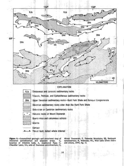
EXPLANATION Cretaceous and Jurassic sedimentary rocks hmq Triasslc, Permian, and Carboniferous sedimentary mcks 1 Dhk I Upper Devonian sedimentary rocks-Hunt Fork Shale and Kanayut Conglomerate 1-1 ..... Devonian sedimentary rocks older than the Hunt Fork Shale Ordovlclan or Cambrian sedimentary mckr Volcanic rocks PI Mount Doonerak Ouartz-mica and calcareous schists ml Granite Contact -I--L Thrust fault; dotted where inferred F9gma 9.-43eneraHzed geologic and structuntt map <strong>of</strong> Mount Daonera~; r, ralsooh Mountain; SS, Woyuk Doonerak anticlinorium and adjacent areas. X, synclinorium; W, Wiseman; WL, Wild Lake (from Dutro loeation <strong>of</strong> trilobite bedst A, Anaktuvuk Pass; C, end others, 1976, fig. 1). Chandler Leke; DA, axis <strong>of</strong> Doonerak anticllnoriurn; Dl
who found Westeqaardodina sp., posble hyouthids, and undetermined accotretid brachiopods. Other samples, from two localities in the gray mwble bodleg, contain micr<strong>of</strong>ossils that, according to Repetski, elso include Westergaarddlna sp., a paraconodont which ranges in age fmm Middle Cambrian into Early Ordovician in many parts <strong>of</strong> the world. It is now clear why we were unable to flnd gap- tolites in this sequence: it is probably entirely Cambrian. The marble bodies and asscxlIated beds provide a key to the geologic mapplng <strong>of</strong> these old rocks. The brown Limestone and gray marble are found as far west as Tobh Creek, on the west-plunging nape <strong>of</strong> the anti- clinorlurn, where they are fsocllnatly folded within the clastic sequence and intrudd by greenstone dikes. Thus, part <strong>of</strong> the mystery <strong>of</strong> Doonerak has been solved. Its Cambrian rmks can be correlated with those <strong>of</strong> the northeastern Brooks Range (Dutro and others, lQ72) and may be related to the Arctic Cam- brian sequences in Siberia, Hllesmerehd, North Greenland, and other parts <strong>of</strong> the North Atlantic Caledonides. These are the oldest fmiliferous rocks thus far dkcovered in the central or western Brooks Range. Further sesrch in the probable southwestward exten- I sion <strong>of</strong> this structural trend should turn up additional discoveries. The search goes on. REFERENCES CITED Brosg6,W. P. and Reiser, H. N., 1971, Prellmjnary bed- rock geologic map, Wiseman and eastern Survey Pass quadrangles, <strong>Alas</strong>ka: O.S. <strong>Geological</strong> Survey open-file map, scale 1:250,000, 2 sheets. Dutro, J. T., Jr., BmsgC,W. P., and Reiser, H. N., 1972, Significance <strong>of</strong> recently discovered Cambrian fossils and rehterpretation <strong>of</strong> NeruoQuk Porma- tion, northeastern Aleska: American Association <strong>of</strong> Petroleum Geologists Bulletin, v. 56, no. 4, p. 808-815. Dutro, J. T., Jr., Brosg6, W. P., Lanphere, M. A., and Reiser, H. N., 1976, Geologic significance <strong>of</strong> Doonerak structural high, central books Renge, <strong>Alas</strong>ka: Amerlcan Association <strong>of</strong> Petroleum Geologists Bulletin, v. 60, no. 6, p. 952-961. Rdser, H. N., hg6, W. P., Dutro, J. T., Jr., and Detterman, R. L., 1971, Preltminary geologic map, M t. Michelson quadrangle, <strong>Alas</strong>ka: U.S. <strong>Geological</strong> Survey open-file map, scale lr200,000, 2 sheets. Reiser, H. N., Brosgd, W. P., Dutro, J. T., Jr., and Dettermm, R L., 1980, Geologic map <strong>of</strong> the Demarcation Point quadrangle, <strong>Alas</strong>ka: U. S. <strong>Geological</strong> Survey Miscellaneous Investigation Series Map 1-1133, scale 1:250,000. Geothermal studies in <strong>Alas</strong>lra: Ccmditlomr at Prudboe sas roents in <strong>Alas</strong>ka as opportunities wlse in holes drilled for other purposes. Ow objective L a htter under standing <strong>of</strong> the tectonics and geothermaknecgy resources, and <strong>of</strong> the geothermal regime <strong>of</strong> permafrost. This year, we completed e study <strong>of</strong> the thermal reglrne in the Prudhoe Bay area on the coast <strong>of</strong> the Beaufort Sea (area 5 <strong>of</strong> fig. 51, on the basis <strong>of</strong> temperature measurements through permafrost In the Rudhoe Bay oilfield that we obtained through the cooperation <strong>of</strong> BP <strong>Alas</strong>ka, Inc., and the Atlantic Richfield Oil Co. An analysh <strong>of</strong> these data, and <strong>of</strong> thermalconductivity measuremenis on samples <strong>of</strong> drill cuttings and frozen core, leads to the following concIusions (~achenbruch and Marshall, 18771 Lachenbruch and others, 1983): 1. The heat flow from the Earth% inbrio5 is 1.33.2 heat-flow units (HPU) (55k8 mW/m 1, a value Wta <strong>of</strong> stable eontlnental regions, similar to the values measured at Cape Thompson (Lachenbruch and others, 1966) and estimated at Barrow (Lachenbruch and &ewer, 1950). 2. me permafrost on land near Prudhoe Bay extends to a depth <strong>of</strong> 630+ m, 50 to 100 percent deeper than permafrost in the mow area. This greater depth is caused by the high thermal conductivity <strong>of</strong> the coarse ice-rich siliceous sediment in the Prudhoe Bey area; only a small thermal gradient is required to transport the heat flowing from the Earth's interior throwh such conductive material. As 8t other sites along the Arctic <strong>Alas</strong>kan the mean annual temperature <strong>of</strong> the Wth's surfaoe has Increased sharply in the pest hundred years. In the Prudhoe Bay area, we estimate that this increase averages about 1.8'~ (from -10.9' to -9.1'~) and that it is aesoeiated with a net accumulation <strong>of</strong> 5 to 6 kcal/cm by the Earth's surfaoe during this perid. Rlsing sea levfil (Hopkins, 1983) and thawing seacuffs (Barnes and others, 1977) pmbably caused the shoreline to advance tern <strong>of</strong> kilometers in the past 20,000 years, so that a part <strong>of</strong> the Continental Shell Ulat is presently the target <strong>of</strong> intensive oil exploration was inundated. A simple heat-conduction mbdel suggests that the warm seabed wlll cause the base <strong>of</strong> Icerich permafrost to rise about 10 m (from 600f m) during the first 2,000 years efter inundation, and thereafter it will rise about 15 m per 1,000 years. Accordingly, this recently Inundated region k probably underlain by near-melting Lcerich permafrost to depths <strong>of</strong> 300 to 500 m; its presence is important to seismic interpretations in oil exploration and to engheering considerations in 011 production. With confirmation <strong>of</strong> the permafrost configuration by <strong>of</strong>fshore drilling, conduction models can yield reliable new Wor mation on the chronology <strong>of</strong> Arctic shorelines. REFBFLENCES CITED Bg Arthur a- Lacbedmlch, John H. Sasq R Vtulghn MmhaU, 'lhornas H. M-, Jr., Robett J. Munroe,and Barnes, Peter, Reirnnitz, Erk, Smith, Oreg, and m e P. Smith Melchior, John, 1977, Bathymetric and shoreline changes, northwestern Prudhoe Bay, <strong>Alas</strong>ka: The U.S. <strong>Geological</strong> Survey% Geothermal Studies U.S. <strong>Geological</strong> Survey Open-Pile Report 77-161, Project is contfnuing to obtafn heat-flow measure- 10 p. -
- Page 1 and 2: n Alas Accompli: ' I.S. GE OLOGI CA
- Page 3 and 4: I CONTENTS Page A bst raet ........
- Page 5 and 6: -- --A I ALASEU i nued rral expluru
- Page 7 and 8: ........ igure .JB. ;5~ercn map ox
- Page 9 and 10: . , ".,k a. ,.e ,\a 1 y U11 IIIUUII
- Page 11: THE UNITED STATES GEOLOGICAL SURVEY
- Page 15 and 16: ~ t I r n t S i m ~ ~ Alarr a ~ man
- Page 17 and 18: I -1977, RelImlnary documentat!on l
- Page 19 and 20: I I MaCenn, W. R., Perez, 0. J., an
- Page 21 and 22: were deslgned to impMve the accurac
- Page 23 and 24: Noatak Sandstom and is overlaln con
- Page 25 and 26: I (Nilsen and others, 1981a); (2) f
- Page 27: I that contains the Upper Devonian
- Page 31 and 32: Table 2 lists the means rtnd for th
- Page 33 and 34: ' Noatak Vdley (fig. 129. This ice
- Page 35 and 36: 3 EUMN OF MAP UNITS WAmWARY OUAERNA
- Page 37 and 38: -om displacement of the cc tween th
- Page 39 and 40: I US I Surlicial dcnrrua,ts [~dater
- Page 41 and 42: I Plafker, George, Hudson, Travis,
- Page 43 and 44: !omlensed iring vapors generated by
- Page 45 and 46: and the thinning. -upward cycles .,
- Page 47 and 48: Kellum, L. B., Devless, S. N., and
- Page 49 and 50: 1912 sample (a mediumwey pumice blo
- Page 51 and 52: various Utholagic units present Thu
- Page 53 and 54: fault, and Its depositional basemen
- Page 55 and 56: suggested by coplanar foUaticm and
- Page 57 and 58: 1 slgnlficarrtly more umnlum (73&1,
- Page 59 and 60: ecrSigtallized catadastic matrix of
- Page 61 and 62: analyzed to determine whether Immob
- Page 63 and 64: are tgplcd of both ocean-floor basa
- Page 65 and 66: & Fclsic in~rutirt rucks 0 Eio~ite
- Page 67 and 68: are Lrdlcated by coexisting @&ite+q
- Page 69 and 70: (Mg3.09 pe2+ 0.69 pe 0.~1~0.01~~0.9
- Page 71 and 72: westward into a narrow band that ex
- Page 73 and 74: EXF'lANATIOW 66600' Contan-Apprnimn
- Page 75 and 76: ! few fold closures are preserved.
- Page 77 and 78: even thickness and conform to irreg
- Page 79 and 80:
(Alnus ap.), heaths (Ericaceae, + E
- Page 81 and 82:
terrane extends at least 300 krn to
- Page 83 and 84:
Table 19.--6tneral petrography of M
- Page 85 and 86:
were measured on 8 12-in. mass spec
- Page 87 and 88:
Thin lenses of cabonate packtone to
- Page 89 and 90:
The cantwell(?) Pormation south of
- Page 91 and 92:
in the 18 lava flows b thermoremane
- Page 93 and 94:
Upper Cretaceous shale in contact w
- Page 95 and 96:
Gran tz, Arthur, 1960, Generalized
- Page 97 and 98:
at 15 to 20 percent. Primary Inolus
- Page 99 and 100:
addition, this factor generally def
- Page 101 and 102:
Joreskog, K. G., Klovan, J. E., and
- Page 103 and 104:
Mineral qItWation end r ~ k t k W e
- Page 105 and 106:
1 "~_liO-/ 200 1000 B roo C E % A B
- Page 107 and 108:
Smaller placer mines ere active on
- Page 109 and 110:
Figme 62.-Plant fassils from the co
- Page 111 and 112:
Hallam, Anthony, 1975, Alfred Wegen
- Page 113 and 114:
u ALASKA Figure 65.--Sketch map of
- Page 115 and 116:
F ' i a?.-Intertidal bluffs compose
- Page 117 and 118:
C-s - - Figure 70.-Products of eros
- Page 119 and 120:
curve is based indicates that 6.1 c
- Page 121 and 122:
sampled is related to widespread ma
- Page 123 and 124:
marble is alsa locally present In t
- Page 125 and 126:
Bedding in the conglomerate ranges
- Page 127 and 128:
1 purpose of this study wes to dete
- Page 129 and 130:
The secona k~~-~ri?tation mmes that
- Page 131 and 132:
epizonb'l granitic Miss, mixed with
- Page 133 and 134:
40 40 Forbes, R. B., and Engels, J.
- Page 135 and 136:
foliated and inequigranular end con
- Page 137 and 138:
I I thy euheclra. Sphene anhedra an
- Page 139 and 140:
Quartz Alkali feldspar Plagioclase
- Page 141 and 142:
F'@m 85.--Sketch map of Juneau area
- Page 143 and 144:
HoUister, L. 8, 1966, Garnet zoning
- Page 145 and 146:
! ~ bI8oO, (IN PERMIL) ~lqp~e 87.-8
- Page 147 and 148:
Figure 90.-Offshore ereas discussed
- Page 149 and 150:
Preliminerg analpsis of miemfauna f
- Page 151 and 152:
Survey tn Alaekai AccompUshments hh
- Page 153 and 154:
Gecllogical Survey Open-File Report
- Page 155 and 156:
I provenance, and tectonia sIgnific
- Page 157 and 158:
Keith, T. E. C, Barnes, Ivan, afrd
- Page 159 and 160:
Open-Flle Report 8P811C, 19 p. + 2
- Page 161 and 162:
United States Qeological Survey in
- Page 163 and 164:
, ,. nldslra poblisbe!d by Prior, D
- Page 165 and 166:
60, Alaska: Offshore Technology Con
- Page 167:
Author Index [Page number underscor
- Page 170 and 171:
Parks. Bruce ......................