

n Alas - Alaska Division of Geological & Geophysical Surveys - State ...
n Alas - Alaska Division of Geological & Geophysical Surveys - State ...
n Alas - Alaska Division of Geological & Geophysical Surveys - State ...

You also want an ePaper? Increase the reach of your titles
YUMPU automatically turns print PDFs into web optimized ePapers that Google loves.
the publlc as a contact polnt for obtaining information<br />
about the activities and pducts <strong>of</strong> the Survey, as<br />
over-the-counter sources <strong>of</strong> map and report products<br />
<strong>of</strong> the U.S. <strong>Geological</strong> Survey, and they provide<br />
referral service for individuals seeking technical<br />
information.<br />
h fiscal year 1981 the Anchorage PIO, staffed by<br />
twb full-time and two part-time employees, replied to<br />
more than 30,000 information requests reaelved in<br />
person, by telephone, and by maU. More than 112,000<br />
topographic and thermetic maps and 2,000 publfcationa<br />
were sold. Some 1,100 people used the reference<br />
library, and more than 800 patrons were assisted in<br />
consulting the files <strong>of</strong> O.S. <strong>Geological</strong> Survey Open-<br />
File Reports on <strong>Alas</strong>ka.<br />
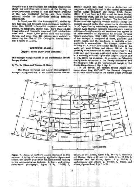
- (Ffgure 5 shows study areas discussed)<br />
The m t Cowbmerate fn tbe weatemmost ~rooke<br />
Ala*<br />
h e Upper Devonian end Lower Missfasippian(?)<br />
Kanayut Conglomerate is an allochthonous coarse-<br />
grained elastic unit that forms a distinctive and<br />
mappable stratigraphic unit in the central and eastern<br />
Brooks Range (Bowsher and Dutm, 1957; Porter,<br />
1966). It Is as thlck as 3,000 m and has been divided,<br />
in ascending order, into the Bar Peak Member, Shainin<br />
Lake Member, and Stwer Member. The Ear Peak and<br />
Stuver members typically contain multiple fining- and<br />
thinning-upward cycles that appear to be characteris-<br />
tic <strong>of</strong> depositlon by meandering streams, whereas the<br />
Shainin Lake Member typically contains more massive<br />
outcrops <strong>of</strong> conglomerate and sandstone that appear to<br />
be characteristic <strong>of</strong> deposition by braided streams<br />
(NUsen and others, 1980, 1Q8lb, 19821. Conglomerate<br />
<strong>of</strong> the Kanayut Is composed <strong>of</strong> chert, quartzite, and<br />
quartz olasts, and the sandstone is typically ortho-<br />
quartzitio in composition. me Kanayut records out-<br />
building <strong>of</strong> a ma'or dominantly fluvial delta to Me<br />
south and west ? Nilsen and others, 198la). It has<br />
generally been considered to pinch out laterally to the<br />
south and west into age-equivalent units. Herein, and<br />
in a recently released Open-File Report (Nilsen and<br />
Moore, 19621, we document its presence in Paleozoic<br />
stratigraphic sequences in the *Husky Mountainsn and<br />
the Mulgrave X U at the westernmost margin <strong>of</strong> the<br />
Broaks Range (area 6, fig. 5; Pig. 6).<br />
In the central and eastern Brooks Range (between<br />
about long 1~6~-147~) the Kanayut Conglomerate<br />
rests conformably on the marine Upper Devonian<br />
FlgUm!! ~.-AII~E~ fn northern <strong>Alas</strong>ka dimused In this Ellersieck and 8 (p. 16-17); 3, Galloway<br />
volume. A listing <strong>of</strong> authorshi , applicable f l<br />
and Koster, figures lu and 11, table 2 (p. 20-21); 4,<br />
tabla, and article pagination P in parenth-~~~?~ Hamilton and Van Etten, figure 12 (p. 21-2311 5,<br />
to the numbered areas follows. 1, Dutro and others, Lachenbruch and others (p. 19-20); 6, Nilsen and<br />
front-cover photograph, flgure 9 (p. 17-19); 2, Moore, figures 6 and 7 (p. 12-16).


