

n Alas - Alaska Division of Geological & Geophysical Surveys - State ...
n Alas - Alaska Division of Geological & Geophysical Surveys - State ...
n Alas - Alaska Division of Geological & Geophysical Surveys - State ...

You also want an ePaper? Increase the reach of your titles
YUMPU automatically turns print PDFs into web optimized ePapers that Google loves.
curve is based indicates that 6.1 cm <strong>of</strong> sedimentation SOUTHEASTERN ALASKA<br />
should have occurred in the 1-year period between<br />
1974 and 1975; however, we measured only 5 cm <strong>of</strong><br />
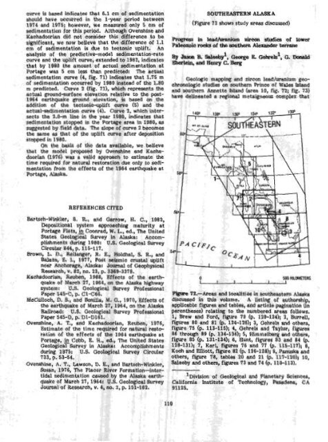
(Figure 72 shows study areas discussed)<br />
sedimentation for this period. Although 0vGshine and<br />
Kachadoorian did not consider this difference to be<br />
significant, we now believe that the difference <strong>of</strong> 1.1<br />
cm <strong>of</strong> sedimentation is due to tectonic uplift. An<br />
analysis <strong>of</strong> the predictive-model sedimentation-rate By J- R saleebyl, George E Gekekl, G. Zknald<br />
curve and the uplift curve, extended to 1982, indicates<br />
3berlein,<br />
that by 1980 the amount <strong>of</strong> actual<br />
and Henry C. Berg<br />
,sedimentation at<br />
Portage was 5 om less than predicted: The actual<br />
sedimentation curve (4, fig. 71) indicates that 1.75 m Geologic mapping and zircon leadlurenium gm<strong>of</strong><br />
sedimentation occurred by 1980 instead <strong>of</strong> the 1.80 chronologic studies on southern Prince <strong>of</strong> Wales Island<br />
rn predicted. Curve 2 (fig. 71), which represents the and southern Annette bland (area 10, fig. 72; fig. 73)<br />
actual ground-surface elevation relative to the post- have delineated a regional rnetaigneous complex that<br />
1964 earthquake ground elevation, is based on the<br />
addition <strong>of</strong> the tectonic-uplift curve (5) and the<br />
actualsedimentation curve (4). Curve 2, which intersects<br />
the 2.0-m line in the year 1980, indicates that<br />
sedimentation stopped in the Portfge area in 1980, as<br />
suggested by field data. The slope <strong>of</strong> curve 2 becomes<br />
the same as that <strong>of</strong> the uplift curve after deposition<br />
stopped in 1980.<br />
on the basis af the data available, We believe<br />
tnat the model proposed by Ovenshine and KachadoorIan<br />
(1976) was a valid approach to estimate the<br />
time required for natural restoration due only to sedimentation<br />
from the effects <strong>of</strong> the 1964 earthquake at<br />
Portage, <strong>Alas</strong>ka.<br />
REFERENCES CITED<br />
Bartsch-Winkler, S. R, and Garrow, H. C., 1982,<br />
Depositional system approaching maturity at<br />
Portage Flats, & Cmnrad, W. L., ed., TRe Ulrited<br />
<strong>State</strong>s <strong>Geological</strong> Survey in <strong>Alas</strong>ka: Accom-<br />
plishments during 1980: U.S. <strong>Geological</strong> Survey<br />
Circular 844, p. 115-117.<br />
Brown, 2. D., Reilanger, R. E., Holdhal, S. R., md<br />
Balazs, E. I., 1977, Post seismic crustal ~ U f t<br />
near Anchorage, <strong>Alas</strong>ka: Journal <strong>of</strong> <strong>Geophysical</strong><br />
Research, v. 82, no. 23, p. 3369-3378.<br />
Kechadoorian, Reuben, 1968, Effects <strong>of</strong> the earth-<br />
quake <strong>of</strong> March 27, 1964, on the <strong>Alas</strong>ka highway<br />
system: U.S. GeologicAl Survey Pr<strong>of</strong>essional<br />
Paper 545-C, p. C1-C66.<br />
WaCLUloch, D. S., and Bonilla, Me G., 1970, Effects <strong>of</strong><br />
the earthquake <strong>of</strong> March 27, 1964, on the <strong>Alas</strong>ka<br />
Railroad: U.S. <strong>Geological</strong> Survey Pr<strong>of</strong>essional<br />
Paper 545-D, p. Dl-D161.<br />
Ovenshine, A. T., end Kachadoorian, Reuben, 1976,<br />
Estimate <strong>of</strong> the time required for natural regto-<br />
ration <strong>of</strong> the effects <strong>of</strong> the 1964 earthquake at<br />
Portage, In Cobb, 6. H., ed., The United <strong>State</strong>s<br />
<strong>Geological</strong> Survey in <strong>Alas</strong>ka: Accomplishm entc<br />
during 1975: U.S. <strong>Geological</strong> Survey Circulai<br />
733, p. 53-54.<br />
Ovenshine, A. T., Lawson, D. E., and Bartsch-Winkler<br />
Susan, 1976, The Placer River Formation-inter-<br />
tidal sdimentatlon caused by the <strong>Alas</strong>ka earth-<br />
quake <strong>of</strong> March 27, 1964: U.S. <strong>Geological</strong> Survey<br />
Souraal <strong>of</strong> Research, v. 4, no. 2, p. 151-162.<br />
FQum 72.-Areas and Icealltie6 In southeBstern <strong>Alas</strong>Ke<br />
discussed in this voltlme. A listing af autbrship,<br />
applicable figures and tables, and article pagination (in<br />
parentheses) relating to the numbered areas follows.<br />
1, Brew and Ford, figure 19 (p. 120-124); 2, Burrell,<br />
figures 80 and 81 (p. 124-126); 3, Gehrels and others,<br />
figure 75 (p. 113-1151; 4, Gehrels and Taylor, figures<br />
86 through 89 (p. 134-1365; 5, Hjmmelberg and others,<br />
fiwe 85 (p. 131-1341; 6, Hunt, figtires 83 and 84 (p.<br />
128-131); 7, Karl, figures 76 and 77 (p. 115-117); 8,<br />
h and Elliott, figure 82 (p. 126-128); 9, Panuska ad ers, figure 78, tables 20 and 21 (p. 117-1~0)~ 10,<br />
!eby and others, figures 73 and 74 (p. 110-1131.<br />
l~ivision<br />
<strong>of</strong> GeolaglcaI md Lanetary WielIea,<br />
California hstftute <strong>of</strong> Technolqy, Pasadena, CA<br />
91125.


