n Alas - Alaska Division of Geological & Geophysical Surveys - State ...
n Alas - Alaska Division of Geological & Geophysical Surveys - State ... n Alas - Alaska Division of Geological & Geophysical Surveys - State ...
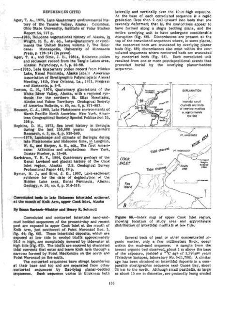
Ager, T. A., 1975, hte Quaternary environmental history of the Tanma Valley, Alaska: Columbus, Ohio State University, Institute of Polar Studies Repmt 54,117 p. -1983, Holocene vegetatimal hfst6ry 09 Alaska, & Wright, H. R., Jr. ed., LateQuaterna~y environments the United States; Volume 2, The Holocene~ Minneapolis, University of Minnesota Press, p. 128-141 [in press?. Ager, T. A,, and Sims, J. D., 1981~1, Holocene pollen end sediment record from the Tangle Lakes area, Alaska: Palynolcgy, v. 5, p. 85-98. -1981b, Lote Quaternaliy pollen record from Hidden Me, Xenai Peninsula, M e [sbs.): American Amlation of Stratigraphic PaIynologists Annual Meeting, 14th, New Orleans, La., 1981, Program and Abstracts, p. 8-9' Denton, G. H., 1974, quaternary glaciations of the White River Valley, Alaska, with a regional synthesis for the northern St, Was Mountains, Alaska and Yukon Territory: Geological Society of America Bulletin, v. 85, no. 6, p. 871-892. Heusser, C. J., 1960, Lote Pleistocene environments of North Pacific North America: New York, American Geographical Weiety Sp~iel Publication 35, 308 p, Hqkins, D. M., 1073, Sea level history in Beringia during the last 250,000 years: Quaternary Research, v. 3, no. 4, p. 520-540. -1979, Landscape and climate of Beringia during late Pleistocene and Holocene time, & LaugNin, W. S., and Harper, A. I3,, eds., The first Americans: Affinities and adaptatiow: New York, Gustav Fischer, p. 15-40. Karlstrom, T. N. V., 1964, Quaternary geology of the Henai Lowlmd and glacial histom of the Cook Inlet region, Alsska: U.S. Geological Survey Profasslonal Paper 443, 69 p. Rymer, M. J., and Sims, J. D., 1982, Lekesedlment evidence for the date of deglaclation of the Hidden M e area, Kenai Peninsda, Alaska: Geology, v. la, no, 6, p. 314-316, Camrbluted be& in hte Haiocene intestidal sediment I .tUle.babofgnUm,-Cmkblet,w Convoluted and contorted intertidal sand-andmud bedded sequence of the present4ay and recent past are exposed in upper Cook Inlet at the mouth of Knk Arm, just southwest of Point Woronzof (loc. 3, fig. 44; fig. 66). These intertidal deposits, which are exposed at low tide in eroded bluffs approximately 10.5 rn high, me completely covered by tidewater at high tide (fig. 67). The bluffs are scoured by channeled tidal currents that enter and leave Knik Arm through a narrows formed by Point MacKenzie on the north and Point Woronzof on the south. The contorted sequences have abrupt boundaries at their base and top and are separated from other contorted sequences by flat-lying planar-bedded sequences. Each sequence vari~ in thickness both laterally and vertically over the 10-m-high exposure. At the base of each convoluted sequence is a rapid gradation (less than 2 cm) upward Into beds that are severely deformed; that is, the contortions appear to have formed along a sfngle bedding plane, and the entire overlying unit to have undergone considerable disruption (fig. 88). Dkcordances ere present at the top of the convoluted sequences where, in some places, the contorted beds are truncated by overlying planar beds (fig. 69); discordances also exist within the con- voluted sequences where contorted beds are truncated by contorted beck (fig. 681. Each convoluted unit resulted Prom one or more postdeposltionfd events that preceded burhl by the overlying planaeedded sequences. Figure 68.-Index map of upper Cook Inlet region, showing locatlon of study ares and approximate distribution of interttdd mudnats at low tide. Several beds oP peat or other concentrated or- ganic matter, only a few millimeters thick, occur within the mud-sand sequence. A sample Prom the lowest organic bed observe bout 1 m above the base of the exposure, yielded age of 3,280i90 years ITeledyne Isotopes, laboratory No. 1-11,706). -A simiLar age has been obtained on In tertidd deposits in a com- parable sbatigraphic sequence near Goose Bay, about 25 km to the north. Although small peatballs, as large as: about 15 cm in diameter, w e presently being eroded
F ' i a?.-Intertidal bluffs composed of unconsolidated silt and snnd aggregate about 9 rn in height from surface of water to tidal flats. Bluffs are result of erosion by tidewater flowing in a channel extendbg from Rnik Arm to upper Cook Inlet. from bluff deposits stratipphieofiy abovs the dated bed (fig. 70B), the absence of outcrops of older peat within or near the study area, as weU as the similarity of es determined on deposits in comparable strati- oa%ic positions, suggests that the age reparted b closely contemporaneous with the enclostng deposits. Landsliding or slumping is probably the primary mechanism by which these sedimentary deposits were deformed, but the events triggering the slumping are speculative. Possible tri ering events include: (1) Earthquakes in the area, 8 undercutting of the sedi- ment by ehmnels, or (3) increase in the stope of local intertidal zones created by channel development. Other deforrnatibnal mechanisms include (1) ice loading in the winter niontlls and (2) wave-induced liquefac- t ion. Anchorage and upper Cook Wet are in a tecton- ically active region characterized by frequent earth- quakes and nearby volcanic activity. Ground shaking of saturated unconsolidated sediment, such as that in the intertidal zones, results in extensive slumping and (or) landsliding. Hansen (1966) documented the major Turnagain Heights landslKde (fig. 66) in the 1964 Alaska earthquake (Richter magni tudc, 8.5). Tectonic events resulting in inplace deformation by dewatering or liquefaction could presumably be recognised in the soft sediment as convoluted layers, and e minimum number of earthquake events could be determined by counting the number of disturbed beds separated by undisturbed beds. Such studies have been undertaken in lake deposits in southern CaIifornirr and on the Kenai Peninsula, 50 krn south of the study aree (Sirns, 1973; Rymer and Sims, 1976). Blocks of ice, which incorporate layers of inter- tidal sand and mud, may grow to housesize dimensions over the course of the winter. These blocks are grounded on the higher intertidal mudflats at low tide (tidal channels are left ice free). At low tide, the weight of these blocks could significantly increase pore pressure in the underlying satursted sediment and cause dewatering and softsediment deformation. Convoluted bedding resulting from ice Loading would be localized in the higher intertidal sandbars, which receive greater numbers of and larger iceblocks. The
- Page 63 and 64: are tgplcd of both ocean-floor basa
- Page 65 and 66: & Fclsic in~rutirt rucks 0 Eio~ite
- Page 67 and 68: are Lrdlcated by coexisting @&ite+q
- Page 69 and 70: (Mg3.09 pe2+ 0.69 pe 0.~1~0.01~~0.9
- Page 71 and 72: westward into a narrow band that ex
- Page 73 and 74: EXF'lANATIOW 66600' Contan-Apprnimn
- Page 75 and 76: ! few fold closures are preserved.
- Page 77 and 78: even thickness and conform to irreg
- Page 79 and 80: (Alnus ap.), heaths (Ericaceae, + E
- Page 81 and 82: terrane extends at least 300 krn to
- Page 83 and 84: Table 19.--6tneral petrography of M
- Page 85 and 86: were measured on 8 12-in. mass spec
- Page 87 and 88: Thin lenses of cabonate packtone to
- Page 89 and 90: The cantwell(?) Pormation south of
- Page 91 and 92: in the 18 lava flows b thermoremane
- Page 93 and 94: Upper Cretaceous shale in contact w
- Page 95 and 96: Gran tz, Arthur, 1960, Generalized
- Page 97 and 98: at 15 to 20 percent. Primary Inolus
- Page 99 and 100: addition, this factor generally def
- Page 101 and 102: Joreskog, K. G., Klovan, J. E., and
- Page 103 and 104: Mineral qItWation end r ~ k t k W e
- Page 105 and 106: 1 "~_liO-/ 200 1000 B roo C E % A B
- Page 107 and 108: Smaller placer mines ere active on
- Page 109 and 110: Figme 62.-Plant fassils from the co
- Page 111 and 112: Hallam, Anthony, 1975, Alfred Wegen
- Page 113: u ALASKA Figure 65.--Sketch map of
- Page 117 and 118: C-s - - Figure 70.-Products of eros
- Page 119 and 120: curve is based indicates that 6.1 c
- Page 121 and 122: sampled is related to widespread ma
- Page 123 and 124: marble is alsa locally present In t
- Page 125 and 126: Bedding in the conglomerate ranges
- Page 127 and 128: 1 purpose of this study wes to dete
- Page 129 and 130: The secona k~~-~ri?tation mmes that
- Page 131 and 132: epizonb'l granitic Miss, mixed with
- Page 133 and 134: 40 40 Forbes, R. B., and Engels, J.
- Page 135 and 136: foliated and inequigranular end con
- Page 137 and 138: I I thy euheclra. Sphene anhedra an
- Page 139 and 140: Quartz Alkali feldspar Plagioclase
- Page 141 and 142: F'@m 85.--Sketch map of Juneau area
- Page 143 and 144: HoUister, L. 8, 1966, Garnet zoning
- Page 145 and 146: ! ~ bI8oO, (IN PERMIL) ~lqp~e 87.-8
- Page 147 and 148: Figure 90.-Offshore ereas discussed
- Page 149 and 150: Preliminerg analpsis of miemfauna f
- Page 151 and 152: Survey tn Alaekai AccompUshments hh
- Page 153 and 154: Gecllogical Survey Open-File Report
- Page 155 and 156: I provenance, and tectonia sIgnific
- Page 157 and 158: Keith, T. E. C, Barnes, Ivan, afrd
- Page 159 and 160: Open-Flle Report 8P811C, 19 p. + 2
- Page 161 and 162: United States Qeological Survey in
- Page 163 and 164: , ,. nldslra poblisbe!d by Prior, D
Ager, T. A., 1975, hte Quaternary environmental history<br />
<strong>of</strong> the Tanma Valley, <strong>Alas</strong>ka: Columbus,<br />
Ohio <strong>State</strong> University, Institute <strong>of</strong> Polar Studies<br />
Repmt 54,117 p.<br />
-1983, Holocene vegetatimal hfst6ry 09 <strong>Alas</strong>ka, &<br />
Wright, H. R., Jr. ed., LateQuaterna~y environments<br />
the United <strong>State</strong>s; Volume 2, The Holocene~<br />
Minneapolis, University <strong>of</strong> Minnesota<br />
Press, p. 128-141 [in press?.<br />
Ager, T. A,, and Sims, J. D., 1981~1, Holocene pollen<br />
end sediment record from the Tangle Lakes area,<br />
<strong>Alas</strong>ka: Palynolcgy, v. 5, p. 85-98.<br />
-1981b, Lote Quaternaliy pollen record from Hidden<br />
Me, Xenai Peninsula, M e<br />
[sbs.): American<br />
Amlation <strong>of</strong> Stratigraphic PaIynologists Annual<br />
Meeting, 14th, New Orleans, La., 1981, Program<br />
and Abstracts, p. 8-9'<br />
Denton, G. H., 1974, quaternary glaciations <strong>of</strong> the<br />
White River Valley, <strong>Alas</strong>ka, with a regional synthesis<br />
for the northern St, Was Mountains,<br />
<strong>Alas</strong>ka and Yukon Territory: <strong>Geological</strong> Society<br />
<strong>of</strong> America Bulletin, v. 85, no. 6, p. 871-892.<br />
Heusser, C. J., 1960, Lote Pleistocene environments <strong>of</strong><br />
North Pacific North America: New York, American<br />
Geographical Weiety Sp~iel Publication 35,<br />
308 p,<br />
Hqkins, D. M., 1073, Sea level history in Beringia<br />
during the last 250,000 years: Quaternary<br />
Research, v. 3, no. 4, p. 520-540.<br />
-1979, Landscape and climate <strong>of</strong> Beringia during<br />
late Pleistocene and Holocene time, & LaugNin,<br />
W. S., and Harper, A. I3,, eds., The first Americans:<br />
Affinities and adaptatiow: New York,<br />
Gustav Fischer, p. 15-40.<br />
Karlstrom, T. N. V., 1964, Quaternary geology <strong>of</strong> the<br />
Henai Lowlmd and glacial histom <strong>of</strong> the Cook<br />
Inlet region, Alsska: U.S. <strong>Geological</strong> Survey<br />
Pr<strong>of</strong>asslonal Paper 443, 69 p.<br />
Rymer, M. J., and Sims, J. D., 1982, Lekesedlment<br />
evidence for the date <strong>of</strong> deglaclation <strong>of</strong> the<br />
Hidden M e area, Kenai Peninsda, <strong>Alas</strong>ka:<br />
Geology, v. la, no, 6, p. 314-316,<br />
Camrbluted be& in hte Haiocene intestidal sediment<br />
I .tUle.bab<strong>of</strong>gnUm,-Cmkblet,w<br />
Convoluted and contorted intertidal sand-andmud<br />
bedded sequence <strong>of</strong> the present4ay and recent<br />
past are exposed in upper Cook Inlet at the mouth <strong>of</strong><br />
Knk Arm, just southwest <strong>of</strong> Point Woronz<strong>of</strong> (loc. 3,<br />
fig. 44; fig. 66). These intertidal deposits, which are<br />
exposed at low tide in eroded bluffs approximately<br />
10.5 rn high, me completely covered by tidewater at<br />
high tide (fig. 67). The bluffs are scoured by channeled<br />
tidal currents that enter and leave Knik Arm through a<br />
narrows formed by Point MacKenzie on the north and<br />
Point Woronz<strong>of</strong> on the south.<br />
The contorted sequences have abrupt boundaries<br />
at their base and top and are separated from other<br />
contorted sequences by flat-lying planar-bedded<br />
sequences. Each sequence vari~ in thickness both<br />
laterally and vertically over the 10-m-high exposure.<br />
At the base <strong>of</strong> each convoluted sequence is a rapid<br />
gradation (less than 2 cm) upward Into beds that are<br />
severely deformed; that is, the contortions appear to<br />
have formed along a sfngle bedding plane, and the<br />
entire overlying unit to have undergone considerable<br />
disruption (fig. 88). Dkcordances ere present at the<br />
top <strong>of</strong> the convoluted sequences where, in some places,<br />
the contorted beds are truncated by overlying planar<br />
beds (fig. 69); discordances also exist within the con-<br />
voluted sequences where contorted beds are truncated<br />
by contorted beck (fig. 681. Each convoluted unit<br />
resulted Prom one or more postdeposltionfd events that<br />
preceded burhl by the overlying planaeedded<br />
sequences.<br />
Figure 68.-Index map <strong>of</strong> upper Cook Inlet region,<br />
showing locatlon <strong>of</strong> study ares and approximate<br />
distribution <strong>of</strong> interttdd mudnats at low tide.<br />
Several beds oP peat or other concentrated or-<br />
ganic matter, only a few millimeters thick, occur<br />
within the mud-sand sequence. A sample Prom the<br />
lowest organic bed observe bout 1 m above the base<br />
<strong>of</strong> the exposure, yielded age <strong>of</strong> 3,280i90 years<br />
ITeledyne Isotopes, laboratory No. 1-11,706). -A simiLar<br />
age has been obtained on In tertidd deposits in a com-<br />
parable sbatigraphic sequence near Goose Bay, about<br />
25 km to the north. Although small peatballs, as large<br />
as: about 15 cm in diameter, w e presently being eroded


