n Alas - Alaska Division of Geological & Geophysical Surveys - State ...
n Alas - Alaska Division of Geological & Geophysical Surveys - State ... n Alas - Alaska Division of Geological & Geophysical Surveys - State ...
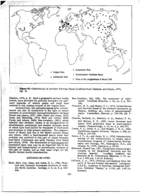
A CathaysIan flora Euramerlan flora o Southwsstsrn American Aoras x Flora ot the conglomerate of Mount Dall F@re 63.-Distribu tion of northern Permian floras (modllied from Chaloner and Meyen, 1973, fig. 3). (Hallem, 1975, p. 9). Such a geographic pattern would, Ben-Avraham, Zvi, 1981, The movement of contl- Indeed, have provided the pathway necessary far east- nents: American Seientkt, v. 69, no. 3, p. 291ward dispersal of Asiatfc plfmts and could have 299. resulted in this Alaskan outpwt of the Angara flora. Chaloner, W. G., and Meyen, S. V., 1973, Carboniferous Alternatively, this paleophy togeograph ic circum- and Permian fldras of the northern continents, In stance can also be interpreted in the light of recent Hallam, Anthony, ed., Atlas of palaeobiogeogconcepts of accretionary tectonostratigraphlc terrmes raphy: Amsterdam, Blsevler, p. 169-186. pls. 1- (Jones and others, 1977, 1981; Dutro and Jones, 1979; 4. Jones and Silberling, 1974; Beck and others, 1980; Churkin, Michad, Jr., Ebwlein, G. D., Hueber, P. M., Coney and others, 1980; Ben-Avrabarn, 1901), which and Marnay, S. H., 1969, Lower Devonlan land indicate that southern Alaska is an amalgematlon of plants from grsptolite shale fn south-eastern ellochthonous continer~tal and oceanic terranes, some Alaska: Pelaeontology, v. 22, no. 4, p. 559-573. of which have been r~fted for thousands of kilometers Coney, p. J., Jones, D. L., M ~ J. W, ~ H., 1980, ~ ~ and accreted to their present positions. The conglom- Cordilleran suspect terranes: Nature, v. 288, no. erate of Mount DaU lies in the Mystic temane (Jones 5789, p. 329-333. and others, lg81), a fault-bounded exotic Dutro, J. T., dr., and Jones, D. L., 1979, Paleotectonic probably was accreted to this part of Alaska between setting of the Carboniferous in Alaska [abs.]: post-Early Cretaceous and early Tertiary time (Reed International Congress of Carboniferous Stratigand others, 1979). The distribution of Zamiopteris and rephy and Geolo!gy, Qth, Washington, D.C., and essociated plant taxa may be an important key to the Urbana, IU., 1979, Abstracts, p. 58-59. history and interpretation of accretionary terranes in Eichwald, ~ d ~ 1871, d [~~~~~t{~-.~~~~t~l~~ this part of Alaska, and an East Asian origin for the remarks on the Mangishlak Peninsula and the Mystic terrane merits consideration. Aleutian Islands]: Acadhie ~rn&aIe dex Solences de St. Petersbourg Mihoires, v. 27, no. REFERENCES CITED 4, p. 1-200, pls. 1-20 [in Rwim]. Fefilova, L. A., 1973, [Permian pteridophyta from the Beck, Myrl, Cox, Allan, and Jones, D. L., 1980, Meso- north of the pre-Uralian depresslonJ: Leningrad, zoio and Cenozoic micropkite tectonics of west- U.S.S.R., Academy of Sciencw, Geological mti- ern North America: Geology, V. 8, no. 9, P. 454- tute, Publisher nNsuka,n p. 1-192, pls. 1-42 [in 456. Rllssianl. 101
Hallam, Anthony, 1975, Alfred Wegener and the hy- pothesis of continental drift: Scientific Ameri- can, v. 232, no. 2, p. 88-97. Jones, D. L., and Silberling, N. J., 1979, Mesozoic sva- tigraphy-the key to tectonic analysis of south- ern and central Alaska: U.S. Geological Survey Open-File Report 79-1200, 37 p. Jones, D. L., Silberling, N. J., Berg, Y. C., and Plafker, George, 1981, Map showing tectonostratigraphic terranes of Alaska, columnar sections, and sum- mary description of terranes: U.S. Geological Survey Open-Pile Report 81-792, 20 p., scale 1:2,500,000. Jones, D. L., Silberlhg, N. J., and Hillhouse, J., 1977, WrmgdXa--a displaced terrane m northwestern North America: Canadian Journal of Earth Sci- ences, v. 14, no. 11, p. 2565-2577. Mamay, 9. H., 1963, Occurrence of Pseudobornia Nathorst in Alaska: Paheobotanist, v. 11, no. L- 2, p. 19-22. Neuburg, M. P., 1948, [Upper Paleozoic flora of the Kusnetzk basin]: Moscow, U.S.S.R., Acackm y of Sciences, Palaeontological Institute, v. 12, no. 3, pt. 2, p. 1-342, pls. 1-73 [in Russian]. Read, C. B., and Marntly, S. H., 1964, Upper Paleozoic floral zones and floral provinces of the United States, with a Glossary of stratigraphic terms, by G. C. Keroher: U.S. Geological Survey Pcofes- sional Paper 454-K, p. K1-K35, pls. 1-19. Reed, B. L., Curtin, G. C., Griscom, Andrew, Nelson, S. W., Singer, D. A., and Stele, W. C., 1979, 'Ibe Alaskan Mineral Resource Assessment Program: Background information to accompany folio of geologic and mineral resource maps of the Td- keetna quadrangle, Alaska: U.S. Geological Survey Circular 775, 17 p. Reed, B. L., and Nelson, S. W., 1977, Geologlc map of the Talkeetna quadrangle, Alaska: U.S. Geologi- cal Survey Miscellaneous Field Studies Map MP- 870-A, scale 1:250,000. 1980, Geologic map of the Talkeetne quadrangle, Alaska: U .S. Geological Survey Miscellaneous Investigations Series Map 1-1174, scale 1t250,000. Schmalhausen, Johannes, 1879, Beitrge zur Jura-Flora RuWends [Contributions to the Jurassic flora of Russia]: Acadhe Irn&ale des Sciences de St. Petersbourg Mhires, v. 27, no. 4, p. 1-96, pls. 1-16. White, David, 1912, The characters of the fossil plant Gigantopteris Schenk and its occurrence in North America: U.S. National Museum Proceedings, v. 41, p. 493-516, pk. 43-49. Zimina, V. C., 1977, [Flora of the Early and the be- ginning of the Late Permian of the South Primor'e]: Moscow, U.S.S.R, Academy of Sci- ences, Publisher "Nauka," p. 1-126, 20 pls. [h Russian]. A middle Wiscansin pollen record from the Copper River basin, Alaska By Cathy L. Connor A 150-rn-thick section, exposed by the Dadina River approxjmately 16 km from its confluence with the Gopper River boc. 4, fig. 44r Valdez D-3 quadrangle), provides an excellent record of middle and late Wisconsin sedimentation on the western flank of Mount Wrangell. A silty clay interval rich in organic material within thIs river-bluff exposure yielded a radiocarbon age of 30,67Oil,050 years. Samples from this interval were analyzed for palynomorphs. Preliminary data indicate that a spruce (Picea)-dominated woodland with intermixed shrub tundra was established by 30,000 years B.P. in the eastern Copper River basin. Thls section (fig. 84 contains four distinct glacial-till units that are separated by sediment representing fluvial, lacustrine, and ~ubglaciel cnvkonments of deposition. The pollen source beds stratigraphically overlie the seoond oldest till and have an upper boundary delineated by a conspicuous seepline 54 m above river level. This silty-clay Interval, 7 m thick, is impermeable to ground water rnovtng through the overlying strata. The gradational boundary bet ween the till and silty-clay unit reflects ablation of glacial ice and onset of shallow stondingwater conditions that were ideal for the growth of peat-forming plants. Upward in the section, immediately above the seepline contact, 3.4 m of white horizontally laminated ashy sand and interbedded clay coarsen upward into lithic and pumice-bearing channeled sand. This sediment indicates sufficient increase in water depth upsection to accommodate a sudden influx of volcanically derived material, presumably representing an ash eruption of Mount Wrmgell. A total of 10 gab samples from a 4.3-m-thick zone within the silty-clay interval were analyzed for fossil spores and pollen, using methods developed by C. E. Schwqer tor alluvial sediment (Matthews, 1974). heUminary data indicate a dominmce of spruce (Picea), as high as 46 percent, followed by sedge (Craceae), 13 percent; birch (Betub), 7 percent; id?$?-), 4 percent; and aide-d, 3 percent in the samples counted. Rerbaceous plants, such as Artemisia, members of the family CaryophyUaceae, Potentilla, and Saussurea are sparse (1-3 percent) as individual groups but m eke up as much as 20 percent of the pollen. Spore-producing plants, such as Sphagnum and Lyeopcdium, make up 8 to 27 percent of the total palynomorphs counted and increase in abundance above the~radiocmbon-dated horizon. Those intervals above the radiocarbondated horlzon also show a decrease in spruce poUen, to a low of 15 percent. Palynomorphs became very sparse at the upper seep-one contact where an increase in water depth is indicated by a transition from silty humus deposits to finely laminated silt and clay. ?he newly Inundated site received pollen and spores that lrad been abraded during transport and diluted by the inflowing sediment. Recovery of usable and sufficient numbem of palynomorphs became particulmly difficult in this type of sedimentary environment. These data suggest that a presentday type of lowland spruce forest with patches of shrub and tundra was extant during middle Wisconsin time in the Dadina River area. This information corroborates the concept of large ice-free areas for much of the Copper River basin during the late Pleistocene, &8 put forth by Perrians and Nichols (1965), and extends the record of vegetational histo~y in this area backward approximately 18,000 years beyond that described by Ager and
- Page 59 and 60: ecrSigtallized catadastic matrix of
- Page 61 and 62: analyzed to determine whether Immob
- Page 63 and 64: are tgplcd of both ocean-floor basa
- Page 65 and 66: & Fclsic in~rutirt rucks 0 Eio~ite
- Page 67 and 68: are Lrdlcated by coexisting @&ite+q
- Page 69 and 70: (Mg3.09 pe2+ 0.69 pe 0.~1~0.01~~0.9
- Page 71 and 72: westward into a narrow band that ex
- Page 73 and 74: EXF'lANATIOW 66600' Contan-Apprnimn
- Page 75 and 76: ! few fold closures are preserved.
- Page 77 and 78: even thickness and conform to irreg
- Page 79 and 80: (Alnus ap.), heaths (Ericaceae, + E
- Page 81 and 82: terrane extends at least 300 krn to
- Page 83 and 84: Table 19.--6tneral petrography of M
- Page 85 and 86: were measured on 8 12-in. mass spec
- Page 87 and 88: Thin lenses of cabonate packtone to
- Page 89 and 90: The cantwell(?) Pormation south of
- Page 91 and 92: in the 18 lava flows b thermoremane
- Page 93 and 94: Upper Cretaceous shale in contact w
- Page 95 and 96: Gran tz, Arthur, 1960, Generalized
- Page 97 and 98: at 15 to 20 percent. Primary Inolus
- Page 99 and 100: addition, this factor generally def
- Page 101 and 102: Joreskog, K. G., Klovan, J. E., and
- Page 103 and 104: Mineral qItWation end r ~ k t k W e
- Page 105 and 106: 1 "~_liO-/ 200 1000 B roo C E % A B
- Page 107 and 108: Smaller placer mines ere active on
- Page 109: Figme 62.-Plant fassils from the co
- Page 113 and 114: u ALASKA Figure 65.--Sketch map of
- Page 115 and 116: F ' i a?.-Intertidal bluffs compose
- Page 117 and 118: C-s - - Figure 70.-Products of eros
- Page 119 and 120: curve is based indicates that 6.1 c
- Page 121 and 122: sampled is related to widespread ma
- Page 123 and 124: marble is alsa locally present In t
- Page 125 and 126: Bedding in the conglomerate ranges
- Page 127 and 128: 1 purpose of this study wes to dete
- Page 129 and 130: The secona k~~-~ri?tation mmes that
- Page 131 and 132: epizonb'l granitic Miss, mixed with
- Page 133 and 134: 40 40 Forbes, R. B., and Engels, J.
- Page 135 and 136: foliated and inequigranular end con
- Page 137 and 138: I I thy euheclra. Sphene anhedra an
- Page 139 and 140: Quartz Alkali feldspar Plagioclase
- Page 141 and 142: F'@m 85.--Sketch map of Juneau area
- Page 143 and 144: HoUister, L. 8, 1966, Garnet zoning
- Page 145 and 146: ! ~ bI8oO, (IN PERMIL) ~lqp~e 87.-8
- Page 147 and 148: Figure 90.-Offshore ereas discussed
- Page 149 and 150: Preliminerg analpsis of miemfauna f
- Page 151 and 152: Survey tn Alaekai AccompUshments hh
- Page 153 and 154: Gecllogical Survey Open-File Report
- Page 155 and 156: I provenance, and tectonia sIgnific
- Page 157 and 158: Keith, T. E. C, Barnes, Ivan, afrd
- Page 159 and 160: Open-Flle Report 8P811C, 19 p. + 2
A CathaysIan flora<br />
Euramerlan flora<br />
o Southwsstsrn American Aoras<br />
x Flora ot the conglomerate <strong>of</strong> Mount Dall<br />
F@re 63.-Distribu tion <strong>of</strong> northern Permian floras (modllied from Chaloner and Meyen, 1973,<br />
fig. 3).<br />
(Hallem, 1975, p. 9). Such a geographic pattern would, Ben-Avraham, Zvi, 1981, The movement <strong>of</strong> contl-<br />
Indeed, have provided the pathway necessary far east- nents: American Seientkt, v. 69, no. 3, p. 291ward<br />
dispersal <strong>of</strong> Asiatfc plfmts and could have 299.<br />
resulted in this <strong>Alas</strong>kan outpwt <strong>of</strong> the Angara flora. Chaloner, W. G., and Meyen, S. V., 1973, Carboniferous<br />
Alternatively, this paleophy togeograph ic circum- and Permian fldras <strong>of</strong> the northern continents, In<br />
stance can also be interpreted in the light <strong>of</strong> recent Hallam, Anthony, ed., Atlas <strong>of</strong> palaeobiogeogconcepts<br />
<strong>of</strong> accretionary tectonostratigraphlc terrmes raphy: Amsterdam, Blsevler, p. 169-186. pls. 1-<br />
(Jones and others, 1977, 1981; Dutro and Jones, 1979; 4.<br />
Jones and Silberling, 1974; Beck and others, 1980; Churkin, Michad, Jr., Ebwlein, G. D., Hueber, P. M.,<br />
Coney and others, 1980; Ben-Avrabarn, 1901), which and Marnay, S. H., 1969, Lower Devonlan land<br />
indicate that southern <strong>Alas</strong>ka is an amalgematlon <strong>of</strong> plants from grsptolite shale fn south-eastern<br />
ellochthonous continer~tal and oceanic terranes, some <strong>Alas</strong>ka: Pelaeontology, v. 22, no. 4, p. 559-573.<br />
<strong>of</strong> which have been r~fted for thousands <strong>of</strong> kilometers Coney, p. J., Jones, D. L., M ~ J. W, ~ H., 1980, ~ ~<br />
and accreted to their present positions. The conglom- Cordilleran suspect terranes: Nature, v. 288, no.<br />
erate <strong>of</strong> Mount DaU lies in the Mystic temane (Jones 5789, p. 329-333.<br />
and others, lg81), a fault-bounded exotic Dutro, J. T., dr., and Jones, D. L., 1979, Paleotectonic<br />
probably was accreted to this part <strong>of</strong> <strong>Alas</strong>ka between setting <strong>of</strong> the Carboniferous in <strong>Alas</strong>ka [abs.]:<br />
post-Early Cretaceous and early Tertiary time (Reed International Congress <strong>of</strong> Carboniferous Stratigand<br />
others, 1979). The distribution <strong>of</strong> Zamiopteris and rephy and Geolo!gy, Qth, Washington, D.C., and<br />
essociated plant taxa may be an important key to the Urbana, IU., 1979, Abstracts, p. 58-59.<br />
history and interpretation <strong>of</strong> accretionary terranes in Eichwald, ~ d ~ 1871, d [~~~~~t{~-.~~~~t~l~~<br />
this part <strong>of</strong> <strong>Alas</strong>ka, and an East Asian origin for the remarks on the Mangishlak Peninsula and the<br />
Mystic terrane merits consideration. Aleutian Islands]: Acadhie ~rn&aIe dex<br />
Solences de St. Petersbourg Mihoires, v. 27, no.<br />
REFERENCES CITED 4, p. 1-200, pls. 1-20 [in Rwim].<br />
Fefilova, L. A., 1973, [Permian pteridophyta from the<br />
Beck, Myrl, Cox, Allan, and Jones, D. L., 1980, Meso- north <strong>of</strong> the pre-Uralian depresslonJ: Leningrad,<br />
zoio and Cenozoic micropkite tectonics <strong>of</strong> west- U.S.S.R., Academy <strong>of</strong> Sciencw, <strong>Geological</strong> mti-<br />
ern North America: Geology, V. 8, no. 9, P. 454- tute, Publisher nNsuka,n p. 1-192, pls. 1-42 [in<br />
456. Rllssianl.<br />
101


