CADD Engineering Standards - Ohio Department of Transportation
CADD Engineering Standards - Ohio Department of Transportation CADD Engineering Standards - Ohio Department of Transportation
Appendix A – CADD Information Table Revised January 20, 2012 By Level Attributes Level Name Description Color Style RW – RIGHT OF WAY – EXISTING (cont’d): Weight Transparency Priority Cell Name Cell Library Name RW_X_Esmt_RS Removal Scenic Easement 5 esmtrsex 2 0 -100 C RW_X_Esmt_SC Scenic Easement 5 esmtscex 2 0 -100 C RW_X_Esmt_SH Standard Highway Easement 5 esmtshex 2 0 -100 C RW_X_Esmt_SL Slope Easement 5 esmtslex 2 0 -100 C RW_X_Esmt_SW Sewer Easement 5 esmtswex 2 0 -100 C RW_X_Esmt_U Utility Easement 5 esmtuex 2 0 -100 C RW_X_Fee_RW Right of Way Fee 5 rowex 2 0 -100 C RW_X_Fee_WL Right of Way Fee with Limitation of Access 5 rowlaex 2 0 -100 C RW_X_Text Right of Way Text 0 0 0 0 500 RW – RIGHT OF WAY - PROPOSED: RW_P_CL_10 Right of Way Centerline, 10 Scale 12 cl10 1 0 500 P RW_P_CL_100 Right of Way Centerline, 100 Scale 12 cl100 1 0 500 P RW_P_CL_1000 Right of Way Centerline, 1000 Scale 12 cl1000 1 0 500 P RW_P_CL_20 Right of Way Centerline, 20 Scale 12 cl20 1 0 500 P RW_P_CL_200 Right of Way Centerline, 200 Scale 12 cl200 1 0 500 P RW_P_CL_2000 Right of Way Centerline, 2000 Scale 12 cl2000 1 0 500 P RW_P_CL_5 Right of Way Centerline, 5 Scale 12 cl5 1 0 500 P RW_P_CL_50 Right of Way Centerline, 50 Scale 12 cl50 1 0 500 P RW_P_CL_500 Right of Way Centerline, 500 Scale 12 cl500 1 0 500 P RW_P_Const_Limits Construction Limits 10 constlimit 0 0 100 C RW_P_Esmt_A Aerial Easement 12 esmtapr 3 0 100 C RW_P_Esmt_CH Channel Easement 12 esmtchpr 3 0 100 C RW_P_Esmt_FL Flowage Easement 12 esmtflpr 3 0 100 C C = Cosmetic P = Physical Levels Do Not Plot NOTE: * Indicates Not By Level Page 83 of 108
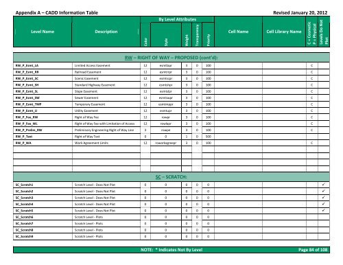
Appendix A – CADD Information Table Revised January 20, 2012 By Level Attributes Level Name Description Color Style RW – RIGHT OF WAY – PROPOSED (cont’d): Weight Transparency Priority Cell Name Cell Library Name RW_P_Esmt_LA Limited Access Easement 12 esmtlapr 3 0 100 C RW_P_Esmt_RR Railroad Easement 12 esmtrrpr 3 0 100 C RW_P_Esmt_SC Scenic Easement 12 esmtscpr 3 0 100 C RW_P_Esmt_SH Standard Highway Easement 12 esmtshpr 3 0 100 C RW_P_Esmt_SL Slope Easement 12 esmtslpr 3 0 100 C RW_P_Esmt_SW Sewer Easement 12 esmtswpr 3 0 100 C RW_P_Esmt_TMP Temporary Easement 12 esmtmppr 3 0 100 C RW_P_Esmt_U Utility Easement 12 esmtupr 3 0 100 C RW_P_Fee_RW Right of Way Fee 12 rowpr 3 0 100 C RW_P_Fee_WL Right of Way Fee with Limitation of Access 12 rowlapr 3 0 100 C RW_P_Prelim_RW Preliminary Engineering Right of Way Line 3 rowpe 3 0 100 C RW_P_Text Right of Way Text 0 0 1 0 500 RW_P_WA Work Agreement Limits 12 roworkagreepr 3 0 100 C SC – SCRATCH: C = Cosmetic P = Physical Levels Do Not Plot SC_Scratch1 Scratch Level - Does Not Plot 0 0 0 0 0 SC_Scratch2 Scratch Level - Does Not Plot 0 0 0 0 0 SC_Scratch3 Scratch Level - Does Not Plot 0 0 0 0 0 SC_Scratch4 Scratch Level - Does Not Plot 0 0 0 0 0 SC_Scratch5 Scratch Level - Does Not Plot 0 0 0 0 0 SC_Scratch6 Scratch Level - Plots 0 0 0 0 0 SC_Scratch7 Scratch Level - Plots 0 0 0 0 0 SC_Scratch8 Scratch Level - Plots 0 0 0 0 0 SC_Scratch9 Scratch Level - Plots 0 0 0 0 0 NOTE: * Indicates Not By Level Page 84 of 108
- Page 152 and 153: Appendix A - CADD Information Table
- Page 154 and 155: Appendix A - CADD Information Table
- Page 156 and 157: Appendix A - CADD Information Table
- Page 158 and 159: Appendix A - CADD Information Table
- Page 160 and 161: Appendix A - CADD Information Table
- Page 162 and 163: Appendix A - CADD Information Table
- Page 164 and 165: Appendix A - CADD Information Table
- Page 166 and 167: Appendix A - CADD Information Table
- Page 168 and 169: Appendix A - CADD Information Table
- Page 170 and 171: Appendix A - CADD Information Table
- Page 172 and 173: Appendix A - CADD Information Table
- Page 174 and 175: Appendix A - CADD Information Table
- Page 176 and 177: Appendix A - CADD Information Table
- Page 178 and 179: Appendix A - CADD Information Table
- Page 180 and 181: Appendix A - CADD Information Table
- Page 182 and 183: Appendix A - CADD Information Table
- Page 184 and 185: Appendix A - CADD Information Table
- Page 186 and 187: Appendix A - CADD Information Table
- Page 188 and 189: Appendix A - CADD Information Table
- Page 190 and 191: Appendix A - CADD Information Table
- Page 192 and 193: Appendix A - CADD Information Table
- Page 194 and 195: Appendix A - CADD Information Table
- Page 196 and 197: Appendix A - CADD Information Table
- Page 198 and 199: Appendix A - CADD Information Table
- Page 200 and 201: Appendix A - CADD Information Table
- Page 204 and 205: Appendix A - CADD Information Table
- Page 206 and 207: Appendix A - CADD Information Table
- Page 208 and 209: Appendix A - CADD Information Table
- Page 210 and 211: Appendix A - CADD Information Table
- Page 212 and 213: Appendix A - CADD Information Table
- Page 214 and 215: Appendix A - CADD Information Table
- Page 216 and 217: Appendix A - CADD Information Table
- Page 218 and 219: Appendix A - CADD Information Table
- Page 220 and 221: Appendix A - CADD Information Table
- Page 222 and 223: Appendix A - CADD Information Table
- Page 224 and 225: Appendix A - CADD Information Table
- Page 226 and 227: Appendix A - CADD Information Table
Appendix A – <strong>CADD</strong> Information Table Revised January 20, 2012<br />
By Level Attributes<br />
Level Name Description<br />
Color<br />
Style<br />
RW – RIGHT OF WAY – PROPOSED (cont’d):<br />
Weight<br />
Transparency<br />
Priority<br />
Cell Name Cell Library Name<br />
RW_P_Esmt_LA Limited Access Easement 12 esmtlapr 3 0 100 C<br />
RW_P_Esmt_RR Railroad Easement 12 esmtrrpr 3 0 100 C<br />
RW_P_Esmt_SC Scenic Easement 12 esmtscpr 3 0 100 C<br />
RW_P_Esmt_SH Standard Highway Easement 12 esmtshpr 3 0 100 C<br />
RW_P_Esmt_SL Slope Easement 12 esmtslpr 3 0 100 C<br />
RW_P_Esmt_SW Sewer Easement 12 esmtswpr 3 0 100 C<br />
RW_P_Esmt_TMP Temporary Easement 12 esmtmppr 3 0 100 C<br />
RW_P_Esmt_U Utility Easement 12 esmtupr 3 0 100 C<br />
RW_P_Fee_RW Right <strong>of</strong> Way Fee 12 rowpr 3 0 100 C<br />
RW_P_Fee_WL Right <strong>of</strong> Way Fee with Limitation <strong>of</strong> Access 12 rowlapr 3 0 100 C<br />
RW_P_Prelim_RW Preliminary <strong>Engineering</strong> Right <strong>of</strong> Way Line 3 rowpe 3 0 100 C<br />
RW_P_Text Right <strong>of</strong> Way Text 0 0 1 0 500<br />
RW_P_WA Work Agreement Limits 12 roworkagreepr 3 0 100 C<br />
SC – SCRATCH:<br />
C = Cosmetic<br />
P = Physical<br />
Levels Do Not<br />
Plot<br />
SC_Scratch1 Scratch Level - Does Not Plot 0 0 0 0 0 <br />
SC_Scratch2 Scratch Level - Does Not Plot 0 0 0 0 0 <br />
SC_Scratch3 Scratch Level - Does Not Plot 0 0 0 0 0 <br />
SC_Scratch4 Scratch Level - Does Not Plot 0 0 0 0 0 <br />
SC_Scratch5 Scratch Level - Does Not Plot 0 0 0 0 0 <br />
SC_Scratch6 Scratch Level - Plots 0 0 0 0 0<br />
SC_Scratch7 Scratch Level - Plots 0 0 0 0 0<br />
SC_Scratch8 Scratch Level - Plots 0 0 0 0 0<br />
SC_Scratch9 Scratch Level - Plots 0 0 0 0 0<br />
NOTE: * Indicates Not By Level Page 84 <strong>of</strong> 108


