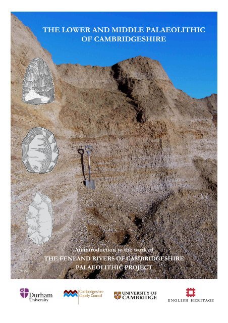
THE LOWER AND MIDDLE PALAEOLITHIC OF CAMBRIDGESHIRE
THE LOWER AND MIDDLE PALAEOLITHIC OF CAMBRIDGESHIRE
THE LOWER AND MIDDLE PALAEOLITHIC OF CAMBRIDGESHIRE

Create successful ePaper yourself
Turn your PDF publications into a flip-book with our unique Google optimized e-Paper software.
<strong>THE</strong> <strong>LOWER</strong> <strong>AND</strong> <strong>MIDDLE</strong> <strong>PALAEOLITHIC</strong><br />
<strong>OF</strong> <strong>CAMBRIDGESHIRE</strong><br />
An introduction to the work of<br />
<strong>THE</strong> FENL<strong>AND</strong> RIVERS <strong>OF</strong> <strong>CAMBRIDGESHIRE</strong><br />
<strong>PALAEOLITHIC</strong> PROJECT
INTRODUCTION<br />
The Palaeolithic or ‘old stone age’ (from the Greek palaeos –old +<br />
lithos – stone) is the earliest archaeological period. In Britain, the<br />
Palaeolithic spans the time from the earliest human occupation, at<br />
present thought to be c.750,000 years ago, until the end of the last ice<br />
age c.10,000 years ago. Unlike later archaeological periods, evidence<br />
from Palaeolithic sites often only consists of concentrations of stone<br />
tools preserved within ancient silts, sands and gravels. The skeletal<br />
remains of ancient humans are very rarely preserved, with only small<br />
fragments of bone and teeth recovered from a handful of British<br />
Palaeolithic sites. In order to understand more about the human<br />
populations that lived in Britain and produced these artefacts,<br />
Palaeolithic archaeologists combine many strands of evidence to<br />
reconstruct the landscape, climate and ecology of the past.<br />
Palaeolithic archaeology is an aspect of Quaternary science, the interdisciplinary<br />
study of the Quaternary geological period (often referred to<br />
as ‘the Ice Age’) which spans the last 2.6 million years. Quaternary<br />
scientists include geologists, archaeologists, soil scientists,<br />
palaeontologists and climatologists, as well as specialists in scientific<br />
dating techniques. All of these sources of evidence can be combined in<br />
various ways to reconstruct past environments and the climatic changes<br />
that have occurred at regular intervals during the Quaternary. The<br />
Quaternary period is subdivided into two epochs; the Pleistocene (2.6<br />
million – c.10,000 years ago) and the Holocene (c.10,000 years ago –<br />
present).<br />
© T. S. White<br />
© Trent Valley Palaeolithic Project
<strong>THE</strong> FENL<strong>AND</strong> RIVERS <strong>OF</strong> <strong>CAMBRIDGESHIRE</strong><br />
<strong>PALAEOLITHIC</strong> PROJECT<br />
The modern county of Cambridgeshire falls between two areas with strikingly different records of early<br />
human occupation. To the north and west are the East Midlands, where Palaeolithic archaeology is<br />
relatively rare and poorly understood; to the south and east lies East Anglia, one of the richest<br />
Palaeolithic landscapes in Europe, which includes the site of Pakefield where the oldest known human<br />
evidence anywhere in Northern Europe was recently discovered. Cambridgeshire itself has produced a<br />
diverse Palaeolithic record dating back c.500,000 years and is an important area for researchers interested<br />
in linking the archaeological and geological records in the Midlands and East Anglia.<br />
Compared to its neighbouring counties of Suffolk and Norfolk, however, Cambridgeshire has received<br />
little attention from researchers in recent years. The Fenland Rivers of Cambridgeshire Palaeolithic<br />
Project (FRCPP) was therefore initiated in 2007 as a short research project to examine the Palaeolithic<br />
and Quaternary evidence from the county. The FRCPP was funded by the Aggregates Levy<br />
Sustainability Fund (ALSF) as a collaborative project between the University of Durham,<br />
Cambridgeshire County Council and the University of Cambridge.<br />
The FRCPP had two main interests:<br />
• the collections of Lower and Middle Palaeolithic stone tools held by various museums and<br />
private collectors<br />
• the ancient deposits of the major rivers flowing across the Cambridgeshire Fenland towards<br />
the Wash (the Great Ouse and Nene, as well as important tributaries such as the Cam) from<br />
which most of these artefacts were recovered.<br />
The sands and gravels deposited by rivers are an important economic resource and are intensively<br />
quarried throughout Cambridgeshire. They are also the source of most of the evidence for Palaeolithic<br />
settlement and Quaternary climate. An important aspect of the project was therefore to provide as<br />
much information as possible about the potential for Palaeolithic and Quaternary material to be<br />
preserved with gravel deposits, so that planners can advise quarrying companies.
The Palaeolithic falls entirely within the Pleistocene epoch and in Britain is also divided, on the<br />
basis of changes in the technology and form of stone tools, into three smaller sub-periods:<br />
The Upper Palaeolithic, c.35,000 – 10,000 years<br />
ago (generally associated with modern humans,<br />
Homo sapiens, right)<br />
© Natural History Museum<br />
The Middle Palaeolithic, c.300,000 – 35,000<br />
years ago (generally associated with the<br />
Neanderthals, Homo neanderthalensis, left)<br />
The Lower Palaeolithic, c.750,000 – 300,000<br />
years ago (generally associated with the archaic<br />
human species Homo heidelbergensis, right)<br />
© Natural History Museum<br />
© Natural History Museum<br />
There is evidence of human occupation in Britain during all three periods, but the populations<br />
were small and occupation was not continuous. The climate has fluctuated throughout the<br />
Quaternary between warm temperate periods similar to the present and extremely cold periods<br />
when ice sheets covered the land. Humans abandoned Britain for warmer parts of mainland<br />
Europe during the cold extremes, returning as the climate returned to more favourable warm<br />
conditions.
<strong>PALAEOLITHIC</strong> RESEARCH IN <strong>CAMBRIDGESHIRE</strong>:<br />
A BRIEF HISTORY<br />
During the nineteenth century, the disciplines of<br />
archaeology and geology were very new and<br />
knowledge about the history of the Earth that is<br />
now taken for granted was unavailable to early<br />
researchers. The evolutionary ideas of Charles<br />
Darwin had also not long taken root, meaning<br />
that many scholars tried to include a theological<br />
aspect in their geological and archaeological<br />
theories. For example, the Great Flood of the<br />
Old Testament was often thought to be<br />
responsible for washing the bones of exotic<br />
animals (such as hyena, lion and hippo) that now<br />
live only in warmer countries into British<br />
deposits.<br />
In the late nineteenth century, suggestions that a<br />
flood was responsible for Quaternary deposits<br />
were abandoned by most scholars in favour of<br />
an Ice Age. This coincided with a widespread<br />
acceptance that Palaeolithic stone tools were<br />
indeed extremely old (another difficult<br />
adjustment to make for a society used to<br />
Creationism) and were connected with the Ice<br />
Age sediments. The study of the Palaeolithic has<br />
therefore been closely linked to the study of<br />
Quaternary geological systems.<br />
The original geological survey of the Cambridge<br />
district was made in 1881 and identified glacial<br />
deposits, ancient river gravels, modern river<br />
gravels and peat deposits among others. The<br />
first artefact to be found in the county was<br />
discovered on a gravel heap by the geologist<br />
William Whitaker in 1862 and given to the great<br />
archaeologist Sir John Evans. Another early find<br />
was made by Mr. A. F. Griffith in 1878 at<br />
Barnwell, where the remains of elephant,<br />
rhinoceros and hippopotamus had been found a<br />
few years earlier.<br />
Because Palaeolithic sites are relatively rare,<br />
Quaternary scientists and Palaeolithic<br />
archaeologists still make considerable use of<br />
collections of stone tools and animal bones made<br />
many decades ago. The work of early researchers<br />
is therefore invaluable. There have been a<br />
number of influential scholars and antiquarian<br />
researchers, many from the University of<br />
Cambridge, who have contributed significantly to<br />
Palaeolithic research in Cambridgeshire and who<br />
are briefly mentioned here:<br />
Professor Thomas McKenny Hughes and Mary Caroline McKenny Hughes<br />
Thomas McKenny Hughes worked for the Geological Survey<br />
between 1861-73 before succeeding Adam Sedgwick as<br />
Woodwardian Professor of Geology at Cambridge in 1873, an<br />
office he held until 1917. He wrote more than fifty research<br />
publications, many relating to glacial and post-glacial phenomena<br />
and deposits. His most important research was done while he was<br />
working for the Geological Survey and in the few years following<br />
his appointment at Cambridge, after which his professorial duties<br />
absorbed most of his time. Hughes stimulated a lot of interest in<br />
geology as he was an excellent lecturer and was very popular with<br />
both students and senior members of the university.<br />
His wife, Mary Caroline (her Christian names were usually omitted from her publications, which identify<br />
her as simply ‘Mrs. McKenny Hughes’), was also interested in Quaternary deposits and archaeology, and<br />
published several papers on sites in Cambridgeshire in the late 19th and early 20th centuries. The most<br />
important site studied by Prof. and Mrs. McKenny Hughes was Grantchester, where an extremely rich<br />
assemblage of Pleistocene molluscs was discovered in an interglacial deposit revealed by coprolite<br />
digging.
Professor John Edward Marr<br />
Miles C. Burkitt<br />
Miles Crawford Burkitt (1890-1971) was a<br />
student of the famous French Palaeolithic<br />
archaeologist, the Abbé Henri Breuil, and<br />
explored prehistoric sites in France and Spain<br />
with both Breuil and Dr Hugo Obermaier,<br />
another eminent early prehistorian. Burkitt<br />
lectured in Cambridge on prehistoric<br />
archaeology, at first on a voluntarily basis, then<br />
officially with a salary of £10 a year, and finally<br />
as a university lecturer in the Faculty of<br />
Archaeology and Anthropology. He also<br />
conducted fieldwork around Cambridgeshire,<br />
notably at the famous Traveller’s Rest Pit site<br />
and at Babraham Park. Burkitt travelled widely<br />
and published a number books and articles on<br />
the Stone Age and prehistoric art around the<br />
world.<br />
John Edward Marr (1857-1933) was another highly respected<br />
geologist from Cambridge who worked on the local Quaternary<br />
deposits. He succeeded Thomas McKenny Hughes as Woodwardian<br />
Professor in 1917, a position he held until 1930. He was particularly<br />
interested in the effects of earth movements and glaciation on<br />
topography and scenery, considering their roles in the formation of<br />
lakes and drainage patterns. In his later years, Marr turned his<br />
attention towards prehistoric archaeology, studying the Pleistocene<br />
deposits in the neighbourhood of Cambridge, and examining the<br />
claims for the existence of flint implements of Pliocene age.<br />
G. Wyman Abbott<br />
Wyman Abbott was a Peterborough solicitor<br />
with an interest in many aspects of prehistory<br />
and was an active collector of Palaeolithic<br />
artefacts during the 1920s. He conducted<br />
fieldwork at gravel pits and brick pits in Fletton,<br />
Woodston and Whittlesey and collected a large<br />
number of Lower and Middle Palaeolithic stone<br />
tools. The material collected from the pits<br />
around Woodston is particularly interesting as it<br />
contains a number of Levallois cores and flakes.<br />
Abbott’s interests lay mainly with later<br />
prehistoric periods, however, and few of his<br />
notebooks and letters refer to the Palaeolithic<br />
finds. This has meant that much of the material<br />
held by museums is difficult to interpret, as<br />
there is no contextual data to accompany them<br />
and the precise pits and levels from which they<br />
were recovered are unknown.<br />
Despite the problems with interpretation, the<br />
Wyman Abbott collections from the<br />
Peterborough district remain the most<br />
comprehensive Palaeolithic record for the river<br />
Nene deposits in Cambridgeshire.<br />
Left: Levallois flake collected by G. Wyman Abbott from a<br />
gravel pit in Woodston, Peterborough (Peterborough<br />
Museum Collection).
<strong>THE</strong> QUATERNARY PERIOD<br />
Although often referred to as simply ‘the Ice<br />
Age’, the Pleistocene was not a continuous<br />
period of extreme cold. There have in fact been<br />
many ‘ice ages’, known as glacials, separated by<br />
periods of warm climate called interglacials.<br />
The Holocene, in which we are living at present,<br />
is in fact the most recent interglacial. The<br />
alternating glacial-interglacial cycle is controlled<br />
by variations in the Earth’s orbit around the sun<br />
and the tilt of its axis. If the global warming<br />
caused by human activities does not<br />
permanently alter the natural chemical balance<br />
of the atmosphere, the world should begin to<br />
enter another glacial period a few thousand years<br />
in the future.<br />
Unravelling the geological record has been<br />
likened to doing a jigsaw puzzle with most of<br />
the pieces missing. This is particularly true for<br />
the Quaternary, as every time an ice sheet<br />
advanced across the landscape during the<br />
intense cold of a glacial, earlier records were<br />
mostly destroyed. Piecing together the<br />
information on the past climates of the<br />
Quaternary is far from straightforward, as the<br />
evidence that survives on land is now very<br />
fragmentary.<br />
Since the 1950s, scientists have been able to<br />
reconstruct a more complex history of<br />
Quaternary climate change by examining the<br />
information contained within sediments drilled<br />
from the ocean floors (right). These sediments<br />
have accumulated continuously and can fill gaps<br />
in the fragmentary records on land. This is<br />
possible because the proportion of different<br />
isotopes of oxygen in seawater varies according<br />
to climate or, more precisely, according to the<br />
amount of ice that exists on the planet. Water<br />
evaporating from the oceans contains more of<br />
the lighter oxygen isotope (O16), which means<br />
that the same is true of ice (the snow and rain<br />
that go to make up ice sheets come from the<br />
evaporation of sea water); the oceans therefore<br />
contain a higher proportion of the heavier<br />
isotope (O18) during glacials when large ice<br />
sheets exist.<br />
© Integrated Ocean Drilling Program, used with permission<br />
These variations are recorded in the shells of<br />
tiny single-celled animals called foraminifera,<br />
which take oxygen into their shells from the<br />
sea-water in which they live. By analysing the<br />
ratios of the isotopes in these shells within<br />
different layers of ocean sediments, the amount<br />
of global ice can be calculated for different<br />
periods of the Quaternary. From these types of<br />
record, around five glacial-interglacial climatic<br />
cycles have been recognized within the last half<br />
million years, each cycle lasting about 100,000<br />
years. The warm interglacial part of each cycle<br />
only accounts for about 10 – 20,000 years of<br />
this time.
Recently these ocean records have been<br />
supplemented by evidence from the ice sheets of<br />
Greenland and Antarctica, which have<br />
accumulated in layers just like sediments. The<br />
lowest and oldest ice layers, sampled by drilling<br />
and retrieving ice cores, provide a history that<br />
extends back over half a million years. Like<br />
ocean sediments, ice cores also show oxygen<br />
isotope variations, as well as containing air<br />
bubbles that represent tiny samples of the<br />
atmosphere at the time of ice formation. From<br />
these we know that the carbon dioxide content<br />
of the air has varied naturally in the past before<br />
modern human actions caused it to increase<br />
alarmingly.<br />
The result of this research has been the oxygen<br />
isotope curve. This illustrates the record of cold<br />
and warm climate conditions throughout the<br />
Quaternary, and provides a way of comparing<br />
the age of sediments on a global scale. The<br />
curve is divided into a series of stages, each of<br />
which is numbered; each glacial period is<br />
assigned an even number, and each interglacial<br />
an odd number. On land, the various glacial and<br />
interglacial periods are often referred to by a<br />
series of names, reflecting important local sites<br />
and sequences. One of the key developments of<br />
recent years has been the correlation of land and<br />
© Trent Valley Palaeolithic Project<br />
ocean sequences. For example, the last<br />
interglacial, known in Britain as the<br />
Ipswichian, has been identified as equivalent<br />
to the early warm part of Oxygen Isotope Stage<br />
5, sub-stage 5e (approximately 125,000 years<br />
ago). Ipswichian deposits can thus be<br />
compared to other MIS5e deposits throughout<br />
the world.<br />
The build-up of huge ice-sheets during the<br />
most severe periods of glaciation also lowers<br />
sea level. Ice-sheets have covered northern<br />
Britain several times, even reaching as far south<br />
as the Thames Valley on one occasion (known<br />
as the Anglian glaciation) about half a million<br />
years ago. Global sea level would have been<br />
around 150 metres lower than present at the<br />
height of the Anglian glaciation, and Britain<br />
would not have been an island, as the shallow<br />
basins that are today the North Sea and the<br />
English Channel would have been dry land<br />
connecting it to mainland Europe. These ‘landbridges’,<br />
as they are often referred to, were<br />
important routes for the migration of both<br />
humans and animals. Indeed, this was very<br />
much the normal Quaternary situation. Sea<br />
level was only high enough to separate Britain<br />
from the continental mainland during the very<br />
warmest periods, i.e. for less than 20% of<br />
Quaternary time.
<strong>THE</strong> FORMATION <strong>OF</strong> S<strong>AND</strong> <strong>AND</strong> GRAVEL DEPOSITS<br />
Deposits of material formed by rivers are<br />
known as fluvial sediments. Some deposits<br />
are coarse sands and gravels, formed during<br />
colder periods when the rivers were more<br />
powerful; other deposits are fine sands and<br />
silts that were laid down when the climate was<br />
warmer and rivers sluggish. The dramatic<br />
changes in the characters rivers and the types<br />
of sediments they deposit are also controlled<br />
by climatic cycles.<br />
As the climate began to warm after a glacial<br />
maximum, the huge quantities of water<br />
released from melting snow and ice (including<br />
permafrost) gave the river the ability to erode<br />
and transport vast quantities of material.<br />
Rivers flowing under these glacial conditions<br />
are known as braided rivers, and have many<br />
channels separated by islands of eroded<br />
gravels. Although the climate was warming,<br />
the temperatures were still very cold, and only<br />
a limited range of vegetation could survive.<br />
The landscape was therefore very bleak,<br />
consisting of wide expanses of gravel<br />
colonized by occasional mosses and hardy<br />
tundra plants. Braided river systems can be<br />
seen today in the glacial and periglacial<br />
landscapes of Iceland, Greenland, Alaska and<br />
the Canadian Arctic, which give an impression<br />
of how Cambridgeshire might have looked as<br />
recently as 13,000 years ago.<br />
©Mike Hambrey, glaciers-online.net. Used with permission<br />
Above: fluvial sands and gravels at Needingworth<br />
Pit, Cambridgeshire.<br />
Left: a typical braided river: the<br />
Tasman River (New Zealand) with<br />
Aoraki / Mount Cook in the<br />
background.<br />
© T. S. White
During interglacial periods, rivers were less<br />
powerful, usually flowing in single meandering<br />
channels. The valley-sides were stabilized by plant<br />
growth, and so coarser sediments were not as<br />
easily eroded and transported. Instead, interglacial<br />
rivers carried a combination of fine sands and<br />
silts, which were usually laid down in abandoned<br />
channel sections (cut-off meanders, known as<br />
oxbow lakes), or on the wider floodplain during<br />
times of flood. If preserved, these fine-grained<br />
interglacial elements of the Quaternary record<br />
often contain organic remains and fossils and can<br />
provide very detailed environmental information<br />
about the local environment. Records of this sort<br />
were often destroyed, however, by subsequent icesheet<br />
advances and erosion by the river in its<br />
higher-energy glacial form.<br />
Above: a fine-grained organic deposit preserved in a<br />
Cambridgeshire gravel pit.<br />
The rich natural resources of<br />
interglacial river valleys made them<br />
extremely attractive to early human<br />
communities like the hunting group<br />
pictured to the right. However,<br />
although life may have been easier<br />
during interglacials, early humans<br />
were able to adapt to a variety of<br />
warm and cold conditions,<br />
probably only leaving Britain<br />
altogether when the climate was at<br />
its coldest.<br />
© T. S. White<br />
Patches of ancient fluvial sand and gravel<br />
deposits can be found scattered across<br />
Cambridgeshire. Their tops often form<br />
relatively flat surfaces known as terraces,<br />
which represent fragments of former valley<br />
floors. Rivers usually form terraces once in a<br />
100,000 year cycle, although it is possible for<br />
two terraces to be formed. Changing climatic<br />
and geological conditions cause the river to<br />
erode into its valley floor (a process known<br />
as downcutting) and deposit large amounts of<br />
coarse fluvial sediment (a process known as<br />
aggradation). The older river deposits are<br />
therefore left ‘high and dry’ when the river<br />
deepens its valley. Repeated downcutting<br />
and aggradation events have created a<br />
‘staircase’ of river terraces, fragments of the<br />
oldest being preserved at the top with each<br />
terrace becoming progressively younger until<br />
the present course of the river is reached. It<br />
is possible to group terrace fragments<br />
together by comparing features such as<br />
height above the current valley bottom, and<br />
the distinctive types of rocks contained<br />
within the gravels. Even if two patches of<br />
sediment are many miles apart, they can be<br />
matched to the same continuous river<br />
terrace. If sufficient fragments survive, the<br />
former floodplain can be mapped. The<br />
evolution of the river systems during the<br />
Quaternary, with minor and sometimes<br />
major course changes, can thus be pieced<br />
together.<br />
© Natural History Museum, used with permission
<strong>THE</strong> RIVERS <strong>OF</strong> <strong>CAMBRIDGESHIRE</strong><br />
All of the river valleys of Cambridgeshire have<br />
been cut into glacial sediments deposited by the<br />
Anglian glaciation and so all the river terraces<br />
are therefore younger than this event (i.e. less<br />
than 500,000 years old). The two major rivers,<br />
the Great Ouse and the Nene, rise on the<br />
Jurassic hills to the west of the county and flow<br />
roughly parallel to each other to the Wash.<br />
They have wide low-lying terraces and<br />
floodplains where they cross the Oxford Clay<br />
into the Fens. Here, the terraces become wide,<br />
delta-like fans. The lowest terrace deposits are<br />
covered with Fen clay or peat, but where they<br />
outcrop as ‘gravel islands’ they have been a<br />
major influence on the location of towns and<br />
villages. Large areas of Cambridgeshire are<br />
extremely low-lying and include Holme Fen, the<br />
UK's lowest physical point at 2.75 m (9 ft)<br />
MAJOR RIVERS <strong>OF</strong> <strong>CAMBRIDGESHIRE</strong><br />
Great Ouse<br />
The Great Ouse is the largest river in Cambridgeshire and the<br />
5th longest in England. The course of the river has been<br />
significantly modified since the 17th century, when the<br />
construction of the Old and New Bedford Rivers was<br />
undertaken in order to drain the Bedford Levels.<br />
Cam<br />
The River Cam is tributary of the Great Ouse and is about 40<br />
miles (64km) long.<br />
The two rivers join to the south of Ely at Pope's Corner. In<br />
earlier times the Cam was named the Granta, but after the<br />
name of the Anglo-Saxon town of Grantebrygge had been<br />
modified to Cambridge, the river was renamed to match. The<br />
two principal tributaries of the Cam are the Granta and the<br />
Rhee, though both are also officially (and confusingly) known<br />
as the Cam. Another minor tributary is the Bourn Brook,<br />
which has its source near the village of Eltisley 10 miles west<br />
of Cambridge, and flows east to join the Cam.<br />
Nene<br />
The River Nene flows for 91 miles (147 km) through<br />
Northamptonshire, Cambridgeshire and Lincolnshire. The<br />
Nene forms the border between Cambridgeshire and Norfolk<br />
for about six kilometres<br />
below sea-level. The Anglian glaciation is<br />
thought to have been responsible for cutting<br />
the huge estuary known as the Wash and<br />
excavating the lowland Fen Basin. At times of<br />
high sea level during the Quaternary the Fen<br />
Basin has therefore been a large embayment of<br />
the sea. Evidence of marine environments has<br />
been found far inland of the present coastline,<br />
such as the marine molluscs that are preserved<br />
in the gravel deposits around March. The<br />
highest point in the county is in the village of<br />
Great Chishill at 146 m/480 ft above sea level.<br />
Other prominent hills, such as the Gog Magog<br />
Downs, Rivey Hill and the Madingley Hills are<br />
capped with gravel deposited by older river<br />
systems, which has acted as armour against<br />
erosion. These hilltop gravel deposits are the<br />
oldest Pleistocene sediments in the county.
The rivers of Cambridgeshire and the Fenland region present unique problems for Quaternary<br />
scientists. In contrast to the Thames and Severn-Avon, which have generally formed one terrace<br />
during each climatic cycle, the valleys of the rivers draining across Cambridgeshire into the Wash<br />
have a relatively low number of terraces. This is partly because their formation began only after the<br />
Anglian glaciation, but even allowing for their short history these rivers have condensed sequences.<br />
One explanation is that single terraces in the Wash rivers can sometimes span more than a single<br />
glacial-interglacial cycle. This is seen in the case of Terrace 1 of the River Welland and Terrace 2 of<br />
the River Cam, which are thought to correlate with one another, both spanning the last two glacialinterglacial<br />
cycles. The difference in numbering between the Welland and Cam has come about<br />
because different Geological Survey mappers have been responsible for each area, the Survey maps<br />
being the primary source of basic information on the extent and identity of terrace deposits. Thus<br />
the Nene and Welland sequences comprise three terraces, whereas the Cam-Ouse system has four. It<br />
is often not possible to distinguish higher (and therefore older) deposits, making interpretation of the<br />
sediments very difficult.<br />
Above: suggested interpretation of the Cambridgeshire river terrace deposits, seen in idealized section (after<br />
Bridgland and Schreve, 2001)
QUARRYING, BRICK-MAKING <strong>AND</strong> COPROLITES<br />
Knowledge of the Palaeolithic period is derived almost entirely from artefacts, animal bones, pollen,<br />
insects and other fossilized remains preserved within deposits exposed by extractive aggregates and<br />
minerals industries. Sand and gravel, clay and ‘coprolites’ have all been quarried extensively across<br />
Cambridgeshire and have formed a major part of the county’s economy.<br />
The Aggregates Industry<br />
As recently as the inter-war years, gravel pits<br />
were still largely dug and sieved by hand,<br />
providing a golden opportunity for collectors to<br />
obtain archaeological and faunal material.<br />
Gravel pit workmen would often gather<br />
Palaeolithic artefacts and animal bones to sell to<br />
collectors, and some very large and significant<br />
artefact collections were amassed in this way.<br />
Some less honest workmen were tempted to<br />
produce forgeries, however.<br />
© T. S. White<br />
Above: a mechanical excavator at work in a gravel quarry.<br />
Above: Mr George ‘Deffy’ Carter sieving gravel by<br />
hand in 1913. Mr Carter, who worked at Maidenhead<br />
in the Thames Valley, gained his nickname from his<br />
love of gramophone records, which he bought with<br />
the money he made by selling stone tools to collectors<br />
(Photo: L. Treacher, reproduced by courtesy of J.J.<br />
Wymer).<br />
In recent years, the mechanization of the sand and<br />
gravel extraction process means that it is now<br />
much more difficult to find Palaeolithic stone<br />
tools and other evidence from the Quaternary.<br />
Research now relies heavily upon the goodwill of<br />
numerous aggregates companies to access the<br />
deeply-buried deposits, which can be many metres<br />
below the present ground surface. Without the<br />
information yielded by these dwindling resources,<br />
most of the evidence for archaic humans and their<br />
activities would have remained undiscovered. The<br />
central irony of the Palaeolithic, then, is that the<br />
industry responsible for revealing the evidence of<br />
ancient human occupation may also be<br />
responsible for its destruction, and it is only<br />
through projects like the FRCPP that this<br />
evidence can be recovered and preserved for the<br />
benefit of future generations.
The Brick Industry<br />
During the late 19th and 20th centuries, the<br />
Fletton and Woodston districts of<br />
Peterborough were the centre of the British<br />
brick-making industry, producing bricks that<br />
were to become known as ‘flettons’. The clay<br />
dug for brick making was excavated by hand<br />
until 1902, when the first mechanical<br />
excavators were brought in so that work could<br />
continue during a strike. Although the clay<br />
being excavated from these sites pre-dates the<br />
Quaternary, post-Anglian gravel deposits and<br />
interglacial sediments have been discovered in<br />
the upper portions of the pits, most famously<br />
at Woodston. Here, estuarine deposits dating<br />
to the Hoxnian interglacial (MIS 11) were<br />
discovered, in which were preserved pollen,<br />
molluscs, insect remains and the bones of<br />
small mammals.<br />
Archaeological material recovered from brick<br />
pits in Woodston and Fletton includes<br />
Levallois cores and flakes, suggesting that<br />
deposits dating to the interglacials in MIS 9<br />
and MIS 7 are also present. There are very few<br />
records of the precise locations for the<br />
archaeological finds, however, and so the<br />
whereabouts of sediments of this age remains<br />
a mystery. Continued quarrying of clay in the<br />
area may lead to their discovery in the future.<br />
Coprolite Digging – an odd business<br />
Between 1850 and 1890, an industry unique to<br />
Cambridgeshire flourished and declined. It was<br />
discovered that the natural phosphatized nodules,<br />
or coprolites, that occurred in the Lower<br />
Greensand deposits between Soham and<br />
Barrington, could be used to manufacture a<br />
powerful fertilizer. The term coprolite usually<br />
refers to the fossilized droppings of animals, often<br />
found in Quaternary cave deposits where boneeating<br />
carnivores such as hyenas were once active.<br />
In this case, however, the term has been applied<br />
to the mineral nodules because of their<br />
resemblance to true coprolites.<br />
Phosphate was the cheapest form of fertiliser<br />
(with the exception of animal manure) and so the<br />
industry boomed. It could be spread on the fields<br />
by hand in the traditional way or could be diluted<br />
with water and placed in a fertiliser drill, a method<br />
often used for the cultivation of root vegetables<br />
such as turnips, swedes and sugar beet. The<br />
bridge across the River Cam at Clayhithe was built<br />
in 1872 specifically to allow coprolite to be<br />
transported more easily. A wharf was also built,<br />
from where the mineral was taken in barges to<br />
Cambridge, Ely or Kings Lynn for subsequent<br />
distribution by sea. By 1900 there were virtually<br />
no coprolite workings left, due to the exhaustion<br />
of the Cambridgeshire deposits and the import of<br />
cheaper phosphate from America. Several<br />
important Quaternary sites were discovered in<br />
coprolite pits, including the interglacial deposits<br />
near Grantchester.<br />
The following resources are a more detailed<br />
overview of this intriguing Cambridgeshire<br />
industry and include further references:<br />
‘Coprolite Mining in England’ by Trevor Ford and<br />
Bernard O’Connor, feature in Geology Today<br />
Vol.18, No.5, September-October 2002.<br />
www.cambridgeshirehistory.com/People/coprolit<br />
ehistory
<strong>LOWER</strong> <strong>AND</strong> <strong>MIDDLE</strong> <strong>PALAEOLITHIC</strong> STONE TOOLS<br />
The working of stone to make tools is referred<br />
to as knapping, and this process has been the<br />
basis of tool manufacture for most of human<br />
history. Even after the use of metals became<br />
widespread during the Bronze Age, stone<br />
continued to be an important raw material.<br />
Knapping is based on the principle of<br />
conchoidal fracture, or the way in which<br />
certain types of brittle stone break very cleanly<br />
to form an extremely sharp edge. In<br />
Cambridgeshire, as in most of the rest of<br />
Britain, the stone most often used by<br />
Palaeolithic knappers was flint. Nodules and<br />
more extensive beds of flint occur in the chalk<br />
bedrock that stretches across the South-East<br />
and East Anglia. In areas where flint was not<br />
available, however, other types of local stone<br />
were substituted, such as quartzite, andesite<br />
and chert. These rocks are not as easy to work<br />
as flint, but can produce equally effective<br />
stone tools in the hands of a practiced<br />
knapper. In Cambridgeshire very few non-flint<br />
Palaeolithic artefacts are known. Lower and<br />
Middle Palaeolithic stone tools are dominated<br />
by four distinctive types of artefact: cores,<br />
flakes, handaxes, and flake tools. Two types<br />
of hammer or percussor were used by<br />
Palaeolithic knappers: hard-hammers, usually<br />
another piece of stone; and soft-hammers,<br />
usually antler or bone, and perhaps wood.<br />
Cores and flakes<br />
When a piece of flint is struck, flakes of stone are removed leaving a central core. Because this type<br />
of knapping often consisted of heavy blows from a hard-hammer, the knapping features on such<br />
objects are very pronounced. The scars left by the flakes on the core are very distinctive. Simple<br />
cores and flakes are highly variable in both size and shape. Sharp edged flakes suitable for cutting are<br />
generally assumed to have been the end goal of this technology, the cores being the waste by-product.<br />
However, some, referred to as choppers or chopper-cores, have a sharp zig-zag edge opposite an<br />
unworked area and it is unclear whether these were specially created to be used in heavy-duty<br />
chopping activities or whether their shape is just coincidental.<br />
Above: a typical Palaeolithic flake with the important<br />
diagnostic features noted<br />
Flake diagnostics<br />
Bulb of percussion: When a flake is<br />
struck from a core, the force of the<br />
blow produces a conical swelling or<br />
bulb next to the striking platform.<br />
The bulb of percussion is one of<br />
the first things to look for when<br />
determining whether a flake is a<br />
genuinely of human workmanship,<br />
as it is rarely present on naturally<br />
broken stone.<br />
Striking platform: The flat surface<br />
from which a flake is struck from a<br />
core.<br />
Bulbar scar: A small secondary flake<br />
detached as the bulb of percussion<br />
forms.<br />
Ripples: These radiate out from the<br />
bulb of percussion, indicating the<br />
direction of the blow that detached<br />
the flake.
The handaxe<br />
Handaxes are perhaps the most<br />
distinctive of all Lower and Middle<br />
Palaeolithic tools. They are<br />
symmetrical, pear-shaped implements<br />
possessing a sharp bifacially-worked<br />
edge around all or part of the<br />
circumference. Unlike simple cores,<br />
handaxes are deliberately shaped objects.<br />
Many are delicately flaked using a soft<br />
hammer to thin their profile, leaving a<br />
complex pattern of scars on both<br />
surfaces. Handaxes were made on<br />
nodules, pebbles or large flakes of<br />
different stone types and can take a<br />
number of different forms around the<br />
basic blueprint. These implements are<br />
often found in large numbers and have<br />
been described as a Palaeolithic ‘Swiss<br />
Army knife’ because they have a wide<br />
variety of potential uses. Microscopic<br />
studies of their edges have shown that<br />
they were most often used in butchery.<br />
Handaxe types and diagnostics<br />
Handaxes come in many shapes and sizes, ranging from small ovate forms to very large pointed<br />
examples. The great Palaeolithic archaeologist, John Wymer, developed as typology of handaxes<br />
which demonstrates the variation in shape.<br />
John Wymer’s handaxe typology:<br />
D: Stone-struck, crude handaxe<br />
E: Small (
Flake tools<br />
Flake tools are modified flakes with additional flaking or retouch on one or more edges. Several<br />
different types are recognised, depending on the nature of the edge produced: scrapers, notches,<br />
denticulates and flaked flakes. Flake tools are not particularly rare, although it is sometimes difficult to<br />
differentiate between man-made and naturally altered edges in sand and gravel deposits. They were<br />
probably used in a variety of wood and hide working activities.<br />
Scraper Notch Denticulate<br />
The handaxe: to have or have not?<br />
Different combinations of these tool forms are used by archaeologists to define different stone<br />
tool industries. In Britain, two Lower Palaeolithic industries are recognised: the Clactonian<br />
(named after the type site at Clacton-on-Sea) and the Acheulian (named after the French village<br />
of St. Achuel in the Somme Valley). The Clactonian is a simple core and flake industry, which<br />
may also contain a variety of flake tools and chopper cores but by definition lacks handaxes. The<br />
Acheulean is defined by the presence of handaxes, but may equally contain a number of flaketools<br />
and cores identical to those found in the Clactonian. The significance of the presence and<br />
absence of handaxes within these two industries, whether the result of different populations each<br />
with their own distinctive tool kit, different toolkits used by the same groups of people for<br />
different purposes, or a response to local raw material suitability, is the subject of heated debate.
Middle Palaeolithic technology and Levallois technique<br />
The Middle Palaeolithic tool kit shows a number of technological advances over the Lower<br />
Palaeolithic. Most notable is the introduction of a new form of core working referred to as the<br />
Levallois technique, which appears in Britain around 300,000 years ago. Levallois is a form of<br />
‘prepared core technology’, in which the core is carefully shaped by removing a series of preparatory<br />
flakes to enable the production of a final flake or series of flakes of predetermined shape and size. In<br />
its classic form Levallois cores are often referred to as ‘tortoise cores’ due to their resemblance to a<br />
tortoise shell, but a number of other variations exist. The Middle Palaeolithic also shows a much<br />
wider range of more sophisticated flake tools, including a large number of different forms of scrapers<br />
with elaborately retouched edges.<br />
With the introduction of Levallois in Britain the number of<br />
handaxes dwindled, Levallois flakes perhaps taking their<br />
place as the main cutting implement. However, the<br />
handaxe reappears some 200,000 years later at the very end<br />
of the Middle Palaeolithic. These later examples are<br />
frequently small and cordiform (heart-shaped). One<br />
peculiar form of late Middle Palaeolithic handaxe, believed<br />
to be unique to this period in Britain, deserves special<br />
mention – the ‘bout coupé’. This is an elongated D-shaped<br />
handaxe with a markedly flat butt and a broad tongueshaped<br />
tip. Bout coupé handaxes often occur as individual<br />
finds on or just beneath the surface.<br />
Left: stages in the preparation of<br />
a Levallois ‘tortoise core’ and the<br />
resulting Levallois core and<br />
flake.<br />
Below: a bout coupé handaxe
RECONSTRUCTING ENVIRONMENT <strong>AND</strong> L<strong>AND</strong>SCAPE<br />
When sediments are laid down in any<br />
geological environment, be it a desert, a lake, a<br />
river valley or beneath an ice sheet, the<br />
sediment and associated features provide a<br />
distinctive record of that environment.<br />
Experienced geologists can read the features<br />
of exposed sediments and identify the<br />
processes that created them, reconstructing<br />
the physical appearance of the landscape.<br />
Sediments can also be sampled for organic and<br />
inorganic remains, which can be used in a<br />
variety of ways. Some are analysed by<br />
laboratory specialists to determine what<br />
species of plants and animals were living in a<br />
given environment at various times during<br />
the Quaternary. Others can be dated, allowing<br />
the development of chronologies and the<br />
comparison of sites of similar date. Some of the<br />
methods used for reconstructing the<br />
environment and landscape are outlined here.<br />
Individually, these analyses can only tell us<br />
about the particular site at which the samples<br />
were collected, a snapshot of a specific place at<br />
a particular time. By combining the information<br />
from a wide range of different samples<br />
collected from several sites, however, we can<br />
begin to reconstruct a continuous history of an<br />
area.<br />
Stone Counting and Gravel Analysis<br />
By studying the different stones that make up gravel deposits, a technique known as ‘clast analysis’, it<br />
is possible to identify where the component rock types originated. Changes in the course of the river<br />
can be mapped by matching distinctive stones in river gravel deposits to the sources from which they<br />
were eroded. Events such as glaciations can also transport ‘exotic’ rocks from far afield and<br />
introduce them into river systems, each event leading to the introduction of new rock types into the<br />
sand and gravel deposits.<br />
The gravels of the Cambridgeshire are rich in flint pebbles derived locally within the river catchments.<br />
Occasionally, more exotic rock types are encountered, such as quartzite from the Midlands. There<br />
are also much less durable Jurassic limestone pebbles from the escarpment to the west, although<br />
these can be regarded as very local components that would not survive long-distance transport in the<br />
rivers.<br />
© T. S. White<br />
Left: examples of gravel clasts likely<br />
to occur in Cambridgeshire gravels.<br />
The most common component is<br />
flint (7). Quartz, quartzite and chert<br />
are derived from the East Midlands<br />
and were transported to<br />
Cambridgeshire by both fluvial and<br />
glacial processes during the<br />
Quaternary.<br />
1: Conglomerate pebble<br />
2: Well-cemented orthoquartzite<br />
3: Poorly-cemented orthoquartzite<br />
4: Metaquartzite<br />
5: Vein quartz<br />
6: Schorl<br />
7: Flint<br />
8: Carboniferous chert<br />
9: Rhaxella chert
Reconstructing Palaeoclimate<br />
Palaeoclimate means ‘ancient climate’. A<br />
number of features and structures found in<br />
sand and gravel deposits are records of the<br />
nature of the climate both during and after<br />
sediment deposition.<br />
During periods of cold climate, the freezing and<br />
contraction of the ground causes the formation<br />
of vertical bodies of ice (ice wedges) within the<br />
deposits, their thickness tapering downwards in<br />
a distinctive V-shape. These structures often<br />
penetrate through the entire sequence of<br />
sediments. When the ice melts, the gap is filled<br />
by material that tumbles in from above, creating<br />
features known as called ice wedge casts.<br />
Research on ice wedges forming today in the<br />
Canadian Arctic suggests that annual air<br />
temperatures of around –6 C are needed for<br />
them to form. Ice wedge casts recorded in the<br />
Cambridgeshire therefore illustrate the severity<br />
of the climate during the glacial periods.<br />
© P. Allen<br />
Above: an exposed ice wedge in a modern arctic region.<br />
The wedge is approximately 3m long.<br />
Although at times climate was harsh, the upper<br />
levels of some of the sand and gravel deposits<br />
show signs of warm-climate soil development.<br />
This type of deposit is known as a palaeolsol<br />
(ancient soil), and indicates that the climate was<br />
comparable with that of the present day.<br />
Finding distinctive features such as these in a<br />
sand and gravel deposit enables geologists to<br />
quickly determine whether the sediments were<br />
deposited during a period of cold or warm<br />
climate<br />
Left: gravel pit section in Essex showing warm-climate<br />
soil formed at the top of a river gravel buried beneath<br />
glacial till. The warm climate soil is indicated by the dark<br />
red coloured areas. It has been disrupted by frost activity<br />
including the formation of an ice-wedge cast (fossil icewedge)<br />
seen in the centre. Compare with the<br />
photograph of a modern ice-wedge above.
ENVIRONMENTAL EVIDENCE FROM<br />
TERRESTRIAL DEPOSITS<br />
Fine-grained sands and silts rich in organic material have been discovered within Quaternary sequences<br />
throughout Cambridgeshire. The remains of plants and animals, both large and small, preserved within<br />
these (usually waterlogged) sediments can help us reconstruct the environments and habitats of the<br />
past.<br />
Plant remains<br />
Pollen grains are the microscopic reproductive<br />
material of flowering plants. Often produced<br />
in vast quantities by wind-pollinated species,<br />
which are therefore the best represented in<br />
sediments, pollen can be transported over<br />
considerable distances. It is highly resistant to<br />
destruction and can survive under the right<br />
conditions for millions of years.<br />
Pollen specialists can identify plant types from<br />
preserved pollen, as different groups of flora<br />
produce characteristic forms of pollen grains.<br />
It is therefore possible to determine the types<br />
of trees, shrubs and grasses that grew in a<br />
particular environment during a specific part<br />
of the Quaternary. Furthermore, because<br />
pollen is widely distributed in the air (as<br />
anyone with hay-fever will tell you), it can<br />
provide a regional picture of the vegetation<br />
growing on the landscape.<br />
As well as pollen, large fragments of plant<br />
material (macrofossils), including tree trunks,<br />
twigs, leaves and seeds, can be preserved and<br />
their species identified. In contrast to pollen,<br />
these remains tend to be deposited relatively<br />
locally and therefore provide an idea of the<br />
plants growing at a specific site, such as the<br />
edges of river channels, lakes and ponds.<br />
Above: pollen grains, magnified several<br />
thousand times (1 mm = one millionth<br />
of a metre)<br />
Left: examples of plant macrofossils (from left to<br />
right): carex seed, birch fruit and a blackberry pip<br />
(rubus)
Animal remains<br />
Remains of animals from Quaternary deposits<br />
consist mainly of bones and shells, the soft parts<br />
of the body only surviving in exceptional cases,<br />
such as the mammoth carcasses frozen in<br />
Siberia. In Britain, animal bones and teeth are<br />
often found in river gravels, and can be used to<br />
determine the prevailing climate when the<br />
deposit was formed. Remains of smaller animals<br />
can also be found, predominantly in the finegrained<br />
organic sediments of interglacials. They<br />
can be used to determine how warm or cold an<br />
interglacial period was, as well as giving an<br />
indication of the types of habitats that would<br />
have existed, such as woodland, grassland, and<br />
tundra.<br />
Fragments of insect exoskeleton are often<br />
found in organic sediments. Wing cases are very<br />
common, although other remains are more<br />
useful for identifying species, especially the<br />
reproductive parts. By identifying the different<br />
species of fossil insects preserved in a deposit, it<br />
is possible to reconstruct their environment by<br />
looking at the habitats of their modern<br />
descendents. Most insects live in very specific<br />
habitats, and many are very intolerant to change<br />
in climate and environment. One advantage<br />
insects have over environmental indicators, such<br />
as vegetation, is that they respond very rapidly to<br />
changes in their environment and are therefore<br />
very sensitive indicators of climate change.<br />
Combinations of insect species of known<br />
environmental distribution can reveal very<br />
precise temperature ranges for past climate.<br />
© T. S. White<br />
Above: tooth of the extinct straight-tusked elephant,<br />
Palaeoloxodon antiquus, recovered from interglacial<br />
sediments dating to MIS 7.<br />
Below: irridescent beetle wing cases washed from<br />
Quaternary sediment<br />
Under specific conditions, the shells of snails and<br />
other molluscs, living on land and in water, may be<br />
preserved. As with other environmental indicators,<br />
individual species have particular ecological<br />
preferences, and can be identified and used to<br />
reconstruct the local environment.<br />
Left: snail shells preserved in Quaternary sediments:<br />
1) Planorbis corneus<br />
2) Bithynia tentaculata<br />
3) Discus rotundatus<br />
4) Theodoxus fluviatilis<br />
5) Aneylus fluviatilis
DATING <strong>THE</strong> SEDIMENTS<br />
There are two types of dating commonly used<br />
by Quaternary scientists; relative and<br />
absolute dating.<br />
Relative dating does not involve any numerical<br />
dates. It is often based on the relationships<br />
observed between deposits. When examining<br />
a geological section, it can usually be assumed<br />
that the oldest deposits are at the bottom of<br />
the sequence, with progressively younger ones<br />
stacked above. Deposits within individual<br />
river terraces conform to this principle, but<br />
the terraces themselves show the opposite, in<br />
BIOSTRATIGRAPHY<br />
As well as helping to reconstruct a picture of<br />
climate and environment, faunal assemblages can<br />
also be used to identify and characterize the various<br />
interglacial episodes. The remains of many different<br />
mollusc and mammal species can be used to obtain<br />
relative dates for geological sediments, especially<br />
where these can be anchored to a well-known<br />
series of terrace deposits. Deposits may contain<br />
fossils which have clearly evolved from an earlier<br />
form found in other deposits, contain groups of<br />
mammals or molluscs that only existed together in<br />
the British Isles during certain periods, or contain<br />
individual species unique to a certain deposit. The<br />
last decade has seen significant advances in tying<br />
these specific mollusc and mammalian groups to<br />
the MIS curve, along with the terrace deposits in<br />
which they are found, a method referred to as<br />
biostratigraphy (building up a chronological<br />
sequence based on biological remains). Some<br />
animals, like the straight-tusked elephant<br />
(Palaeoloxodon antiquus), now extinct, were present in<br />
Britain during each of the last five interglacials and<br />
so are of little use for biostratigraphy. Others<br />
occurred only during some these episodes and so<br />
are of greater value. Taking the last interglacial as<br />
an example, this uniquely contains hippopotamus,<br />
but not horse, humans or the mollusc species<br />
Corbicula fluminalis. Finding hippopotamus within a<br />
deposit can be sufficient to assign it to the<br />
Ipswichian, even if an absolute date is not available.<br />
that the higher terraces are older than those<br />
further down the ‘staircase’.<br />
In recent years, however, advances have been<br />
made in correlating some of the relative dating<br />
sequences to the oxygen isotope curve, thereby<br />
providing a means of locating these sequences<br />
within Quaternary timescales. One way in which<br />
this has been done is through the different<br />
terrace formations of British rivers (principally<br />
the Thames), where a model of terrace formation<br />
based on climate and uplift has suggested that<br />
during each climatic cycle a new terrace is<br />
produced.
GEOCHRONOLOGY<br />
Since the 1950s a number of scientific dating<br />
techniques have been developed which allow<br />
precise age estimates to be calculated. This<br />
type of dating is known as absolute dating, and<br />
methods have been developed to date a variety<br />
of mineral and fossil remains found in<br />
sediments.<br />
Radiocarbon dating is one of the bestknown<br />
techniques, but can only be confidently<br />
used for materials which are less than 30,000<br />
years old. Because the FRCPP is dealing with<br />
deposits that are sometimes almost 20 times<br />
older than this, two comparatively new<br />
absolute dating techniques, both developed in<br />
the last few years, have been used to date the<br />
sands and gravels.<br />
Optically Stimulated Luminescence<br />
Dating (OSL) measures the natural radiation<br />
that builds up in geological deposits over time.<br />
All sediments contain tiny amounts of natural<br />
radioactive isotopes, and the radiation from<br />
these elements is absorbed by quartz or<br />
feldspar grains in the surrounding sediment.<br />
Exposure to sunlight resets the radioactive<br />
signal stored in grains to zero, and so samples<br />
are collected in light-proof tubes. In a<br />
laboratory darkroom (below), grains taken<br />
from the centre of the sample can be made to<br />
emit their stored radiation in the form of light<br />
(luminescence), which can be measured and<br />
used to estimate the amount of time that has<br />
elapsed since they were buried. An OSL date<br />
therefore represents the date at which the<br />
deposit was laid down, not the age of the grain<br />
itself.<br />
OSL has been most successfully used to date<br />
aeolian (wind-blown) sediments, which have<br />
generally been zeroed by exposure to light before<br />
burial. In the last few years, however, scientists<br />
have attempted to use OSL to date both glacial<br />
and fluvial sediments, in which the grains are less<br />
likely to have always been zeroed.<br />
Amino Acid Racemization Dating (AAR)<br />
works by analyzing the amino acids that form<br />
proteins. Protein is an essential part of life: every<br />
cell of every organism contains proteins in<br />
different amounts. However, proteins decompose<br />
very rapidly when an organism dies, and so the<br />
AAR technique relies on protein preserved within<br />
single crystals of the calcium carbonate shells of<br />
snails, which has been preserved from the<br />
moment the snail died.<br />
The amino acids can exist in two forms, that are<br />
chemically the same, but mirror images of each<br />
other, just like left and right hands. Amino acids<br />
in living organisms are all left-handed (L), but<br />
when the organism dies, gradually a reaction<br />
occurs until there are an equal number of lefthanded<br />
and right-handed (D) amino acids. The<br />
ratio of right-handed to left-handed, or D to L,<br />
therefore increases with time and the<br />
measurement of this ratio of amino acids (the DL<br />
ratio) is used to date the shell.<br />
AAR can be used to provide age estimates for<br />
individual mollusc shells preserved in organic<br />
sediments within sand and gravel deposits. It<br />
cannot be used to date all sites, of course, as<br />
mollusc shells are<br />
often not preserved<br />
and some are<br />
unsuitable for this<br />
type of dating. The<br />
opercula of Bithynia<br />
tentaculata (right) have<br />
been most<br />
successfully used for<br />
AAR dating.
COMBINING <strong>THE</strong> EVIDENCE:<br />
CREATING A PORTRAIT <strong>OF</strong> <strong>PALAEOLITHIC</strong> LIFE<br />
As we have seen, the archaeology and landscape<br />
of the Palaeolithic can only be reconstructed by<br />
connecting many lines of inquiry. Every new<br />
strand of evidence adds to the picture of Britain<br />
during the Palaeolithic, and as new sites are<br />
discovered and scientific techniques are<br />
improved our understanding of prehistoric life<br />
continues to expand.<br />
In some respects Lower and Middle Palaeolithic<br />
archaeology has more in common with<br />
palaeontology than with later archaeological<br />
periods. We have remarkably little from which<br />
to reconstruct the lives of ancient humans,<br />
often no more than stone tools and the bones<br />
of wild animals preserved in sands and gravels.<br />
These early people left no monuments,<br />
recognisable architecture or complex<br />
settlements, and their effects on the natural<br />
landscape were minimal. On extremely rare<br />
occasions wooden artefacts have been<br />
preserved, such as the famous Clacton Spear,<br />
discovered in 1911 at Clacton-on-Sea and<br />
dating to approximately 450,000 years ago,<br />
making it the oldest wooden object from the<br />
British Isles.<br />
The evidence we have suggests that they lived<br />
as simple hunter-gatherers who adapted their<br />
lifestyles to meet the challenges of surviving in<br />
the harsh natural environments around them.<br />
Their lifestyle was probably highly mobile but at<br />
the same time very local.<br />
© Natural History Museum<br />
Archaeologists believe that they moved between<br />
a number of well known places in search of food<br />
and other raw materials, foraging for vegetable<br />
foodstuffs and hunting and butchering the<br />
animals that roamed the landscape. They had no<br />
true homes as such, but many temporary camps;<br />
they rarely moved resources further than an hour<br />
or two’s walk and made most of their tools where<br />
suitable raw materials naturally occurred.<br />
Their stone tool kits tell us much about their<br />
level of technological sophistication, the<br />
decisions they took in making them and the skill<br />
and intelligence that this required. The shape<br />
and edges of the tools also allow us to infer the<br />
range of materials on which they were used,<br />
including meat, hides, wood and other plants.<br />
Many tools were involved in butchery, but others<br />
were probably used to make other vital<br />
equipment such as animal skin clothing and<br />
wooden implements. Amazingly, 400,000 yearold<br />
examples of wooden spears have been found<br />
at Clacton-on-Sea in Essex and at the German<br />
site of Schöningen, preserved under exceptional<br />
circumstances. These just hint at the potential<br />
range of tools, manufactured on perishable<br />
materials such as wood and bone, that are now<br />
lost to the Palaeolithic archaeologist. Hunting<br />
was probably based around frequent visits to<br />
places where animals were known to congregate,<br />
such as riverbanks, or where they could be easily<br />
ambushed, such as the gorge at Creswell Crags.<br />
© Natural History Museum<br />
Abo<br />
ve:<br />
the<br />
Clac<br />
ton<br />
Spe<br />
ar,<br />
disc<br />
ove
Glossary<br />
Acheulian – a Lower Palaeolithic stone tool<br />
industry characterized by handaxes, named after<br />
the site at St. Acheul, France.<br />
alluvium – sand, silt and gravel deposited by<br />
rivers, sometimes spread over quite large areas<br />
during flooding.<br />
amino acid – an organic compound, the main<br />
component of proteins. There are over 100<br />
amino acids, but only 20 are commonly found<br />
in living organisms.<br />
andesite – volcanic, igneous rock named after<br />
the Andes mountains of South America where<br />
it is commonly formed.<br />
Anglian glaciation – a period when much of<br />
Britain was covered in ice, extending from<br />
about 480,000 until about 300,000 years ago.<br />
biface – a stone artefact, commonly a handaxe,<br />
that has been flaked on both faces.<br />
braided river – a river overloaded with<br />
sediment and forced to divide into many<br />
channels separated by shifting bars or islands.<br />
chert – a very hard sedimentary rock<br />
commonly found as nodules in limestone as<br />
well as in beds as a primary deposit. It is closely<br />
related to flint, the main difference being that<br />
the latter is found in chalk.<br />
Clactonian – Lower Palaeolithic stone tool<br />
industry made distinct from the Acheulean by<br />
the complete absence of handaxes (probably).<br />
conchoidal fracture – (literally, shell-like) - the<br />
manner in which materials such as flint or glass<br />
fracture with a smooth curved surface.<br />
Devensian glaciation – a period when much<br />
of Britain was covered in ice, extending from<br />
about 70,000 until about 10,000 years ago.<br />
epoch – the smallest unit of geological time,<br />
being a subdivision of a geological period (e.g.<br />
the Pleistocene is an epoch of the Quaternary<br />
period).<br />
exoskeleton – the hard outer covering of<br />
invertebrate organisms such as insects.<br />
flint – a very hard sedimentary silica-based rock<br />
that occurs mainly as nodules or thin beds in<br />
chalk. It breaks to form thin, sharp splinters<br />
when struck with another object, making it a<br />
perfect raw material for stone tool manufacture.<br />
flintknapping – see knapping<br />
fluvial sediments – material deposited by the<br />
action of a stream or river, often sands and<br />
gravels.<br />
foraminifera – tiny, single-celled marine animals<br />
with a hard shell composed of calcium<br />
carbonates that can be analysed to determine the<br />
oxygen isotope ratio in sea water.<br />
glacial period, glaciation – a period of intense<br />
cold, lasting centuries or millennia, during which<br />
ice-sheets and glaciers form.<br />
glaciofluvial sediments – material deposited by<br />
the action of a stream or river fed by a glacier or<br />
ice sheet.<br />
Holocene - the warm period in which we now<br />
live, which began about 10,000 years ago. It is<br />
now thought of as an ongoing interglacial of the<br />
Pleistocene.<br />
Homo heidelbergensis – the Latin name given<br />
to a human species which may have been<br />
ancestral to both modern humans and<br />
Neanderthals. H. Heidelbegensis appears to have<br />
flourished from about 750,000 years ago; in<br />
Britain remains have been found at Boxgrove in<br />
Sussex dating from around 500,000 years ago.
Homo Neanderthalensis – the Latin name<br />
for a species closely related to, but distinct<br />
from, modern humans; popularly known as<br />
‘Neanderthal Man’, they seem to have coexisted<br />
with our own species for about 170,000<br />
years, before becoming extinct about 30,000<br />
years ago.<br />
Homo sapiens sapiens – the Latin speciesname<br />
for modern humans (Homo = man, sapiens<br />
= wise); we appear to have been around for<br />
about 200,000 years.<br />
Industry – a group of archaeological<br />
assemblages found over a specific region or<br />
corresponding to a certain period of time<br />
containing similar artefacts, e.g. the Clactonian<br />
industry.<br />
interglacial period – a warm episode between<br />
two glacial periods or ‘Ice Ages’.<br />
isotope – one of two or more forms of an<br />
element, chemically identical but with different<br />
atomic weights.<br />
knapping – a technique for making stone tools<br />
by striking flakes from a core of stone with<br />
various types of percussor.<br />
Levallois technique – knapping technique in<br />
which a core is carefully prepared in order to<br />
produce flakes of a predetermined size and<br />
shape.<br />
meander – a loop-like bend in a stream or river<br />
channel.<br />
megafauna – large animals, often – as in the<br />
cases of the mammoth and woolly rhinoceros –<br />
more massive equivalents of species which<br />
survive today, which roamed the landscapes of<br />
the Lower and Middle Palaeolithic and were<br />
hunted by their human inhabitants.<br />
Neanderthal – see homo Neanderthalensis.<br />
outwash – gravels, sands, silts and clays<br />
deposited by meltwater flowing outwards from<br />
a glacier.<br />
oxbow lake - a lake formed in the abandoned<br />
channel of a river meander.<br />
palaeo- - from the Greek palaios meaning<br />
ancient, of ancient times. For example,<br />
Palaeoclimate = ancient climate.<br />
Palaeolithic period – The Old Stone Age<br />
(Greek palaios = ‘old’, lithos = ‘stone’); covers<br />
the period from when the earliest ancestral<br />
human species began to manufacture tools<br />
(about 2.5 million years ago, but what is now<br />
Europe effectively begins, as far as we know at<br />
present, about 800,000 years ago), extending<br />
until about 10,000 years ago. The period is<br />
usually subdivided into ‘Lower’ (before 300,000<br />
BP), ‘Middle’ (300,000 – 35,000 BP) and<br />
‘Upper’ (35,000 – 10,000 BP).<br />
palaeontology – the study of the fossil remains<br />
of plants and animals.<br />
percussor – a hammer or striking object used<br />
in flint knapping, which can be made of stone<br />
(for ‘hard-hammer’ techniques) or antler or<br />
bone (for ‘soft-hammer’ techniques).<br />
periglacial – conditions prevailing close to an<br />
ice sheet, but not covered in ice. The ground is<br />
often permanently frozen save the active layer,<br />
resulting in waterlogging of the surface during<br />
summer as drainage is impossible. Such areas<br />
support only tundra vegetation.<br />
permafrost – a layer of soil that has remained<br />
permanently frozen from a few to several<br />
thousand years.
Pleistocene – the most recent major<br />
geological epoch (dating from c. 2.6 million –<br />
10,000 years ago), colloquially known as the<br />
‘Ice Age’ due to cyclical expansion and<br />
contraction of glaciers.<br />
quartzite – usually a metamorphic form of<br />
pure quartz sandstone altered due to heat and<br />
pressure. Some quartzites are sedimentary in<br />
origin, however.<br />
Quaternary – the geological period which<br />
extends from about 2,000,000 years BP until<br />
the present, subdivided into two epochs, the<br />
Pleistocene (2 million – 10,000 years ago) and<br />
the Holocene (10,000 years ago – present).<br />
retouch – further intentional modification of<br />
the sharp edge of a stone tool to suit certain<br />
jobs or to re-sharpen the implement.<br />
Further Reading<br />
Barton, Nick (2005). Ice Age Britain. Batsford, London<br />
river terrace – fragments of ancient river<br />
floodplain surfaces preserved as distinctive flat<br />
steps in the valley side as the river channel cuts<br />
downwards.<br />
scar – distinctive concave feature on the<br />
surface of stone tool where a flake has been<br />
removed.<br />
terrace – see river terrace.<br />
till – material deposited by the movement of<br />
glaciers typically stiff cay containing boulders<br />
and therefore sometimes referred to as ‘boulder<br />
clay’.<br />
uplift – elevation of land surface due in part to<br />
the removal of the great weight of an ice sheet,<br />
and a contributing factor to downcutting of<br />
river channels<br />
Grove, Richard (1976). The Cambridgeshire Coprolite Mining Rush. Oleander Press, Cambridge<br />
Hillier, Richard (1981). Clay that Burns: a History of the Fletton Brick Industry. London Brick Company,<br />
London.<br />
Lord, John W. (1993). The Nature and Subsequent Uses of Flint Vol.1: The Basics of Lithic Technology.<br />
Lowe, J. J. and Walker, M. J. C. (1997). Reconstructing Quaternary Environments, 2nd Edition. Pearson<br />
Prentice Hall, London.<br />
Wymer, J. J. (1999). The Lower Palaeolithic Occupation of Britain (2 Vols). Wessex Archaeology and<br />
English Heritage
Weblinks<br />
Ancient Human Occupation of Britain Project (AHOB) - www.nhm.ac.uk/hosted_sites/ahob<br />
Cresswell Crags - www.creswell-crags.org.uk<br />
National Ice Age Network - www.iceage.bham.ac.uk<br />
Quarry Products Association (QPA) - www.qpa.org<br />
Quaternary Research Association (QRA) - www.qra.org.uk<br />
Trent Valley Palaeolithic Project - www.tvpp.org<br />
Trent Valley Geoarchaeology - www.tvg.org<br />
Young Archaeologists Club (YAC) - www.britarch.ac.uk/yac<br />
The Fenland Rivers of Cambridgeshire Palaeolithic Project Team<br />
Steve Boreham, Department of Geography, University of Cambridge<br />
David Bridgland, Department of Geography, Durham University<br />
Kasia Gdaniec, Development Control Archaeologist, Cambridgeshire County Council<br />
Mark White, Department of Archaeology, Durham University<br />
Tom White, Department of Archaeology, Durham University<br />
Specialists:<br />
Kirsty Penkman, Department of Archaeology, University of York<br />
Richard Preece, Department of Zoology, University of Cambridge<br />
Danielle Schreve, Department of Geography, Royal Holloway University of London<br />
Contact Us<br />
Further details of this project are available from:<br />
Kasia Gdaniec<br />
Cambridgeshire County Council<br />
Castle Court<br />
Castle Hill<br />
Cambridge<br />
CB3 0AP<br />
Mark White<br />
Department of Archaeology,<br />
University of Durham<br />
Science Site<br />
South Road<br />
Durham<br />
DH1 3LE, UK
Acknowledgments<br />
The Fenland Rivers of Cambridgeshire Palaeolithic Project and this publication were funded with a<br />
grant from the Aggregates Levy Sustainability Fund (ALSF) through DEFRA and administered by<br />
English Heritage (Project Number 5266 MAIN). Our thanks go to Jim Leary and Kath Buxton of<br />
English Heritage for project management and support.<br />
We would like to offer our sincere thanks to the curators of the museums visited during the project to<br />
record Palaeolithic artefacts from Cambridgeshire, and the HER officers at Cambridge and<br />
Peterborough for their help with local records. Their time and patience in accommodating our work is<br />
greatly appreciated:<br />
Rebecca Casa Hatton (Peterborough HER)<br />
Bob Burn-Murdoch (St. Ives Museum)<br />
Sarah Poppy (Cambridgeshire HER)<br />
Matt Riley (Sedgwick Museum of Geology, Cambridge)<br />
Ben Robinson (Peterborough HER)<br />
Anne Taylor (Museum of Archaeology and Anthropology, Cambridge)<br />
Glenys Wass (Peterborough Museum)<br />
We would also like to offer our thanks to the following companies and individuals:<br />
Hanson Aggregates<br />
Mr. Alan Holloway<br />
Lastly, thanks to Chris Orton and David Hume of the Durham Digital Design and Imaging Unit for<br />
their care and patience in the production of the illustrations in this publication.<br />
Bibliographic details of this booklet:<br />
White, T. S., Boreham, S., Bridgland, D. R., Gdaniec, K. and White, M. J. (2008) The<br />
Lower and Middle Palaeolithic of Cambridgeshire.