34. Port Charcot - Antarctic Treaty Secretariat
34. Port Charcot - Antarctic Treaty Secretariat
34. Port Charcot - Antarctic Treaty Secretariat

Create successful ePaper yourself
Turn your PDF publications into a flip-book with our unique Google optimized e-Paper software.
<strong>Port</strong> <strong>Charcot</strong>,<br />
Booth Island<br />
65°04’S, 64°02’W<br />
Key features<br />
Description<br />
TOPOGRAPHY<br />
FAUNA<br />
FLORA<br />
OTHER<br />
Visitor impacts<br />
KNOWN IMPACTS<br />
POTENTIAL IMPACTS<br />
Landing Requirements<br />
SHIPS*<br />
VISITORS<br />
Visitor Area<br />
LANDING AREA<br />
CLOSED AREAS<br />
GUIDED WALKING AREAS<br />
FREE ROAMING AREAS<br />
<strong>Port</strong> <strong>Charcot</strong>, Booth Island<br />
- Historic site of <strong>Charcot</strong>’s 1st French <strong>Antarctic</strong><br />
Expedition (HSM 28)<br />
- All three pygoscelid species of penguins<br />
nest on the island<br />
- Glacial scenery<br />
visitor site guide<br />
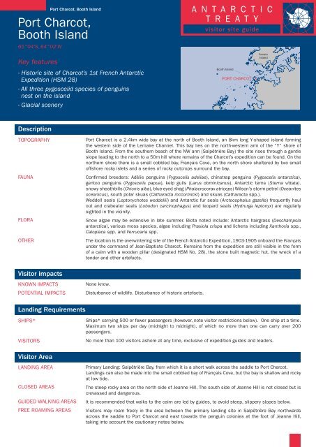
<strong>Port</strong> <strong>Charcot</strong> is a 2.4km wide bay at the north of Booth Island, an 8km long Y-shaped island forming<br />
the western side of the Lemaire Channel. This bay lies on the north-western arm of the “Y” shore of<br />
Booth Island. From the southern beach of the NW arm (Salpêtrière Bay) the site rises through a gentle<br />
slope leading to the north to a 50m hill where remains of the <strong>Charcot</strong>’s expedition can be found. On the<br />
northern shore there is a small cobbled bay, Français Cove, on the north shore sheltered by two small<br />
offshore rocky islets and a series of rocky outcrops surround the bay.<br />
Confirmed breeders: Adèlie penguins (Pygoscelis adeliae), chinstrap penguins (Pygoscelis antarctica),<br />
gentoo penguins (Pygoscelis papua), kelp gulls (Larus dominicanus), <strong>Antarctic</strong> terns (Sterna vittata).<br />
snowy sheathbills (Chionis alba), blue-eyed shag (Phalacrocorax atriceps) Wilson’s storm petrel (Oceanites<br />
oceanicus), south polar skuas (Catharacta mccormicki) and skuas (Catharacta spp.).<br />
Weddell seals (Leptonychotes weddellii) and <strong>Antarctic</strong> fur seals (Arctocephalus gazella) frequently haul<br />
out and crabeater seals (Lobodon carcinophagus) and leopard seals (Hydrurga leptonyx) are regularly<br />
sighted in the vicinity.<br />
Snow algae may be extensive in late summer. Biota noted include: <strong>Antarctic</strong> hairgrass (Deschampsia<br />
antarctica), various moss species, algae including Prasiola crispa and lichens including Xanthoria spp.,<br />
Caloplaca spp. and Verrucaria spp.<br />
The location is the overwintering site of the French <strong>Antarctic</strong> Expedition, 1903-1905 onboard the Français<br />
under the command of Jean-Baptiste <strong>Charcot</strong>. Remains from the expedition are still visible in the form<br />
of a cairn with a wooden pillar (designated HSM No. 28), the stone built magnetic hut, the wreck of a<br />
tender and other artefacts.<br />
None know.<br />
Disturbance of wildlife. Disturbance of historic artefacts.<br />
A N T A R C T I C<br />
T R E A T Y<br />
Booth Island<br />
PORT CHARCOT<br />
Ships* carrying 500 or fewer passengers (however, note visitor restrictions below). One ship at a time.<br />
Maximum two ships per day (midnight to midnight), of which no more than one can carry over 200<br />
passengers.<br />
No more than 100 visitors ashore at any time, exclusive of expedition guides and leaders.<br />
Primary Landing: Salpêtrière Bay, from which it is a short walk across the saddle to <strong>Port</strong> <strong>Charcot</strong>.<br />
Landings can also be made into the small cobbled bay of Français Cove, but the bay is shallow and rocky<br />
at low tide.<br />
The steep rocky area on the north side of Jeanne Hill. The south side of Jeanne Hill is not closed but is<br />
crevassed and dangerous.<br />
It is recommended that walks to the cairn are led by guides, to avoid steep, slippery slopes below.<br />
Visitors may roam freely in the area between the primary landing site in Salpêtrière Bay northwards<br />
across the saddle to <strong>Port</strong> <strong>Charcot</strong> and east towards the penguin colonies at the foot of Jeanne Hill,<br />
taking into account the cautionary notes below.<br />
Anvers<br />
Island
<strong>Port</strong> <strong>Charcot</strong>, Booth Island<br />
<strong>Port</strong> <strong>Charcot</strong>,<br />
Booth Island<br />
65°04’S, 64°02’W<br />
Key features<br />
- Historic site of <strong>Charcot</strong>’s 1st French <strong>Antarctic</strong><br />
Expedition (HSM 28)<br />
- All three pygoscelid species of penguins<br />
nest on the island<br />
- Glacial scenery<br />
Visitor code of conduct<br />
BEHAVIOUR ASHORE<br />
CAUTIONARY NOTES<br />
Landing<br />
site<br />
Cairn<br />
A N T A R C T I C<br />
T R E A T Y<br />
visitor site guide<br />
Walk slowly and carefully. Maintain a precautionary distance of 5m from wildlife and give animals the<br />
right-of-way. Increase this distance if any change in behaviour is observed. Do not touch, disturb or move<br />
historic artefacts.<br />
Avoid walking in the deep snow pathways created by penguins.<br />
The sea-area in the vicinity of <strong>Port</strong> <strong>Charcot</strong> is poorly surveyed.<br />
Care needs to be taken in the vicinity of historic artefacts (see map), some of which may be partially<br />
hidden by snow.<br />
The permanent ice slopes are crevassed and dangerous. These areas should only be accessed by those<br />
with suitable alpine experience and training, and using suitable equipment (e.g. roped access).<br />
Caution must be used when walking close to the snow overhangs east of the Salpêtrière Bay landing<br />
site, which may be unstable.<br />
Penguin<br />
colonies<br />
65°3’45"<br />
65°4’S<br />
Rallier<br />
Island<br />
Hervéou<br />
Point<br />
64°3’<br />
0 500<br />
Metres<br />
R allier C annel<br />
PORT CHARCOT<br />
Cholet<br />
Island<br />
64°2’<br />
64°3’ 64°2’<br />
50<br />
25<br />
/<br />
S a l p ê t r i è r e<br />
B a y<br />
Approx. contours (m)<br />
Crevassed area<br />
Snow Clif f<br />
Penguin breeding area<br />
Closed area<br />
Cairn<br />
Route to cairn<br />
Artefacts<br />
/ Boat landing site<br />
Français <strong>Port</strong> <strong>Charcot</strong><br />
Cove Vanssay Point<br />
25<br />
Jeanne<br />
Hill<br />
50<br />
75<br />
125<br />
100