Sheffield Bus Map & Guide - Stagecoach Supertram
Sheffield Bus Map & Guide - Stagecoach Supertram
Sheffield Bus Map & Guide - Stagecoach Supertram

Create successful ePaper yourself
Turn your PDF publications into a flip-book with our unique Google optimized e-Paper software.
<strong>Sheffield</strong> <strong>Bus</strong> <strong>Map</strong> & <strong>Guide</strong> 04/05/2012 16:41 Page 1<br />
A B C D E<br />
F G<br />
Main bus routes in & around<br />
1<br />
1<br />
Stocksbridge<br />
Junction 36<br />
KEY<br />
Evenings and Sundays Only<br />
Evenings and Sundays Only<br />
Certain Journeys Only<br />
Bolsterstone<br />
Evenings Only<br />
Moss<br />
Way<br />
2<br />
2<br />
Junction<br />
35A<br />
Harley<br />
Evenings only to High Green<br />
Sundays only to Chapeltown<br />
High<br />
Green<br />
Evenings and Sundays Only<br />
Evenings Only<br />
INDEX TO PLACES<br />
B<br />
H<br />
P<br />
Bradway B10 Hackenthorpe F9 Park Hill D7<br />
Thorpe<br />
Brightside D5 Halfway F10 Parson Cross C5<br />
3<br />
Hesley<br />
Brincliffe B8 Handsworth F8 Pitsmoor D6 3<br />
Chapeltown<br />
Broomhill B7 Harley D2<br />
Burncross C3 Heeley D8<br />
R<br />
C<br />
High Green C2 Ranmoor B7<br />
Hillsborough B6 Richmond E8<br />
Burncross<br />
Chapeltown D3 Hollinsend E9 Rotherham G4<br />
Crookes B7<br />
Junction<br />
L<br />
S<br />
35<br />
D<br />
Lodge Moor A7 <strong>Sheffield</strong> D7<br />
Smithywood<br />
Darnall E7 Loxley A6 Shirecliffe C6<br />
Drive<br />
E<br />
Southey Green C5<br />
M<br />
Ecclesfield C4 Malin Bridge B6<br />
W<br />
F<br />
Manor Park D7 Walkley B7<br />
Wharncliffe<br />
Grenoside Ecclesfield<br />
Mosborough F10 Waterthorpe G9<br />
Firth Park D5<br />
Side<br />
Wharncliffe Side A4<br />
Frecheville F9 N<br />
Woodhouse G8<br />
Fulwood A8 Newhall D6 Woodseats C9<br />
4<br />
G<br />
Norwood C5 Worrall A5<br />
4<br />
Greenhill C10 O<br />
Grimesthorpe D6 Oughtibridge B4<br />
Shiregreen<br />
Oughtibridge<br />
Rotherham<br />
Parson Cross<br />
Junction<br />
34<br />
5<br />
Southey<br />
Green<br />
5<br />
Worrall<br />
Middlewood<br />
Firth<br />
Tinsley<br />
Meadowhall<br />
Norwood<br />
Park<br />
Canklow<br />
South<br />
Tinsley<br />
Brightside<br />
Junction<br />
34<br />
Hillsborough<br />
Leppings<br />
Shirecliffe<br />
Lane<br />
Carbrook<br />
Grimesthorpe<br />
Hillsborough<br />
Park<br />
Hillsborough<br />
6<br />
Loxley<br />
Interchange<br />
Valley<br />
6<br />
Centertainment<br />
Junction<br />
Malin<br />
Malin<br />
Newhall<br />
33<br />
Bridge<br />
Bamforth<br />
Bridge<br />
Pitsmoor<br />
Street<br />
Arena/<br />
Don Valley<br />
Europa<br />
Stadium<br />
Langsett Road/<br />
Primrose View<br />
Greenland<br />
Attercliffe<br />
Walkley<br />
Infirmary<br />
Road<br />
Shalesmoor<br />
Woodbourn<br />
Nunnery Road<br />
<strong>Sheffield</strong> City Centre Hyde Cricket Square<br />
Darnall<br />
Park Inn Road<br />
Crookes<br />
7<br />
7<br />
Park<br />
Lodge<br />
Broomhill<br />
<strong>Sheffield</strong> Hill<br />
Moor<br />
Rail Station<br />
Ranmoor<br />
Manor<br />
Park<br />
Park Grange<br />
Fulwood<br />
Richmond<br />
Croft<br />
Handsworth<br />
Spring<br />
Lane<br />
Arbourthorne<br />
Road<br />
8<br />
8<br />
Brincliffe<br />
Manor Top/<br />
Elm Tree<br />
Woodhouse<br />
Heeley Arbourthorne<br />
Hollinsend<br />
Hollinsend<br />
Frecheville<br />
Gleadless<br />
Townend<br />
Hemsworth Gleadless<br />
Hackenthorpe<br />
Herdings<br />
Park<br />
White<br />
Herdings/ Lane<br />
Leighton Road<br />
Birl<br />
9<br />
Woodseats<br />
Birley<br />
Graves<br />
Park<br />
Abbeydale<br />
Beauchief<br />
Greenhill<br />
0<br />
Bingley Lane<br />
Redmires Road<br />
Blackbrook R oad<br />
Lane<br />
Crimicar<br />
River Loxley<br />
Stopes Road<br />
Rig gs High Ro ad<br />
Rivelin Valley R oad<br />
Crimicar Lane<br />
Ringinglow Road<br />
Rowell Lane<br />
River Rivelin<br />
Manchester Road<br />
G range Road<br />
Hallam<br />
Burnt Hill Lane<br />
Loxley Road<br />
Owler Gate<br />
Lumb Lane<br />
La ne<br />
Kirk Edge Road<br />
Stubbing Lane<br />
Myers Lane<br />
Sandygate Road<br />
Tom Lane<br />
Fulwood Road<br />
Ecclesall Road South<br />
Hagg Lane<br />
Abbeydale<br />
Gree n<br />
Bents Rd .<br />
More Hall Lane<br />
Road South<br />
Long Lane<br />
Deer Park<br />
Road<br />
Roscoe Bank<br />
Sandygate Road<br />
Oakbrook Rd .<br />
High Storrs Rd.<br />
Manchester Road<br />
Wharncliffe Side<br />
Primary School<br />
Acorn<br />
Drive<br />
Oldfield<br />
Church Road<br />
St.<br />
Whirlowdale Road<br />
Cockshutts Ln.<br />
Long L n.<br />
Rodney Hill<br />
Rivelin Valley Road<br />
Greysto nes Road<br />
Ecclesall Rd.<br />
Ma n c h e ster Road<br />
Church St.<br />
Greaves Lane<br />
Stannington<br />
Road<br />
83 88 88A Ringinglow Road<br />
Haggstones Road<br />
Dobcroft Road<br />
Langsett Road Sth.<br />
River Don<br />
S tat i on Ln.<br />
Stockarth Ln.<br />
Worrall Road<br />
Loxley Road<br />
Wood Lane<br />
Bole Hill Roa d<br />
Rustlings Road<br />
Manc hester Road<br />
Fulwood Road<br />
Endcl i f f e<br />
Abbeydale Road South<br />
A b b ey Lane<br />
Middlewood Rd. Nth.<br />
Hallowmoor Rd.<br />
Stannington Rd.<br />
Vale Rd.<br />
Woodhead Road<br />
O ug htibridge L a ne<br />
Ben Lane<br />
Carter Knowle Road<br />
Spri n gfield Rd.<br />
C ross<br />
L ane<br />
57<br />
Crookes R d .<br />
Hutcliffe<br />
Langsett<br />
Avenue<br />
Dykes Hall Road<br />
Manchester Rd.<br />
265<br />
265<br />
88A<br />
57<br />
SL<br />
83<br />
88<br />
SL<br />
57<br />
88<br />
265<br />
83<br />
SL<br />
57<br />
83<br />
Northern<br />
57<br />
General<br />
Hospital 265<br />
88<br />
83<br />
83<br />
83<br />
88<br />
52<br />
265<br />
SL2<br />
52<br />
52<br />
123<br />
120<br />
123<br />
120<br />
88 83<br />
57<br />
57.SL<br />
57<br />
SL<br />
SL 57<br />
265 to Barnsley<br />
69<br />
Main <strong>Bus</strong> Routes<br />
57<br />
<strong>Sheffield</strong> Megarider zone<br />
SL<br />
70.71<br />
120<br />
Route terminus<br />
25<br />
78<br />
123<br />
123<br />
57.SL<br />
35A<br />
79<br />
Darnall<br />
Railway line and station<br />
to Wharncliffe Side<br />
215<br />
See map below<br />
83<br />
Tram line and station<br />
87<br />
265<br />
<strong>Sheffield</strong> Megarider<br />
88<br />
<strong>Sheffield</strong> Interchange<br />
boundary extends<br />
50.50A.53<br />
SL<br />
to Stocksbridge<br />
Chapeltown,<br />
52.N52<br />
SL2<br />
57.SL<br />
Hospital<br />
87<br />
Norfolk Arms<br />
to Stocksbridge<br />
57<br />
89<br />
See inset map above<br />
X17<br />
35A<br />
87<br />
87<br />
Chapeltown<br />
57<br />
SL<br />
78<br />
78<br />
87<br />
265<br />
78<br />
79<br />
Rotherham<br />
Central<br />
87<br />
69<br />
78<br />
79<br />
St. Lawrence<br />
Road<br />
20<br />
69<br />
20<br />
20 87<br />
78<br />
20A<br />
Meadowhall<br />
79<br />
Interchange<br />
69<br />
20<br />
20<br />
69<br />
78<br />
79<br />
87<br />
78<br />
79<br />
69<br />
N52<br />
20<br />
87<br />
SL2<br />
N52<br />
69<br />
52<br />
N52<br />
Darnall<br />
N52<br />
25<br />
123<br />
Royal<br />
Hallamshire<br />
123<br />
52<br />
Hospital<br />
N52<br />
53<br />
120 123<br />
52<br />
120<br />
N52<br />
123<br />
25<br />
215<br />
44.44A.87 89 79<br />
X17<br />
Woodhouse<br />
83<br />
87<br />
52N52<br />
88. 88A<br />
52123N52<br />
215<br />
25 25<br />
83 88 25.43.43A<br />
83<br />
89.X17<br />
123<br />
25<br />
88<br />
79<br />
50<br />
215<br />
20<br />
53<br />
120<br />
Bents Road/<br />
Ecclesall Road South<br />
123<br />
120<br />
120<br />
20<br />
20<br />
87<br />
79<br />
89.X17<br />
215 to<br />
Bakewell<br />
79<br />
Dore<br />
8<br />
120 123<br />
Bents Green<br />
88A<br />
88A<br />
Unsliven<br />
Bridge<br />
Hawthorne<br />
Avenue<br />
Holme Ln.<br />
Wal kley Bank Rd.<br />
Springvale Rd.<br />
Nort hfield Rd.<br />
Clarkeho<br />
Road<br />
use<br />
Ecclesall<br />
Road<br />
Psalter Lane<br />
Wood Rd.<br />
Bocking<br />
Lane<br />
Bockin g Lane<br />
Abbeydale Road<br />
Ave<br />
Gree<br />
Moorland Dr.<br />
Sports<br />
Centre<br />
<strong>Sheffield</strong><br />
<strong>Bus</strong> & Tram<br />
Whitwell Ln.<br />
Stone Moor Road<br />
Network <strong>Map</strong> & <strong>Guide</strong><br />
SL2<br />
Middlewood Rd.<br />
South Road<br />
Western<br />
Bank<br />
Stubbing House Ln.<br />
SL<br />
Glossop<br />
Abbeydale Rd.<br />
The D a le<br />
Cedar Rd.<br />
Meadowhead<br />
Halifax Ro ad<br />
S k e w<br />
Woodhead Road<br />
Hill Ln.<br />
Fox Hill Rd.<br />
Fox Hill Road<br />
Penistone Road<br />
Warminster Road<br />
Main Street<br />
Avenue<br />
Wilcox Rd.<br />
H alifax Road<br />
Penistone Roa d<br />
Penistone Road<br />
Penistone<br />
North<br />
Rd.<br />
Langsett<br />
Road<br />
Road<br />
Chesterfield Roa<br />
Coal P i t<br />
Lane<br />
Victoria Rd.<br />
Infirmary<br />
Road<br />
C hesterfield Rd.<br />
Derbyshire Lane<br />
Howbrook Ln.<br />
Berry<br />
Cockshot Lane<br />
Herries<br />
London Road<br />
Lane<br />
P k<br />
Neepsend Ln.<br />
Lees Hall Road<br />
Bramall Ln.<br />
Hall<br />
Halifax Road<br />
Deerlands<br />
Road<br />
Nor t on L a n e<br />
Hollinb erry Ln.<br />
Westwood New Road<br />
Cowper<br />
Wordsworth Ave.<br />
River Don<br />
Myrtle<br />
Hemsworth Road<br />
Towne nd L a ne<br />
Thompso n Hill<br />
Wood Road<br />
Ave.<br />
Firshill<br />
Crescent<br />
School<br />
Drive<br />
burn<br />
k<br />
Hill<br />
Bracken<br />
Blac<br />
Wheel Lane<br />
Creswick Ln.<br />
A616<br />
Manchester Road<br />
20A<br />
<strong>Sheffield</strong> Wednesday F.C.<br />
Hillsborough<br />
Hillsborough<br />
Leisure Centre<br />
20A<br />
20A<br />
25.43.43A<br />
44.44A<br />
Chaucer Rd.<br />
Lane<br />
Elliott<br />
Whitley Lane<br />
Rutland Road<br />
Pitsmoor Rd.<br />
Road<br />
Carr Rd.<br />
Lane<br />
Yew Lane<br />
So uthey Gre en Road<br />
Ad lington Road<br />
Shirecliffe Rd.<br />
Way<br />
Foster<br />
Springwood<br />
20 N52<br />
20A 52<br />
20.20A<br />
44.44A<br />
87<br />
East Bank Rd.<br />
Spencer Road Gleadless<br />
Blackstock<br />
Blackstock Rd.<br />
field Outer Ring Rd.)<br />
Deerlands Avenue<br />
Park Grange<br />
Mortomley<br />
Lane<br />
Wordsworth Avenue<br />
Moonshine Lane Longley Ave.<br />
20 20A<br />
Rock St.<br />
Nursery St.<br />
Road<br />
Greengate Ln.<br />
Holgate Ave.<br />
Burngreave Rd.<br />
West<br />
Spital Hill<br />
Road<br />
Wortley<br />
Rd.<br />
Road<br />
Manchester Road<br />
Worra l l<br />
Ro a d<br />
Bur ncross Road<br />
Be v a n W ay<br />
C rowder Rd.<br />
Chapel Road<br />
Monteney Road<br />
Lindsay Avenue<br />
Elm Lane<br />
Scott Rd.<br />
East Bank Road<br />
Leighton Road<br />
Hartley Brook Road<br />
Hucklow Rd.<br />
Petre Street<br />
Carlisle Street East<br />
Manor Ln.<br />
Road Manor Ln.<br />
Eastern Avenue<br />
Mill Rd.<br />
High Greave<br />
Road<br />
Barnsley<br />
Road<br />
City Rd.<br />
Soughley Lane<br />
Church St.<br />
High Street<br />
Longley Lane<br />
Herries Road<br />
Maltravers Ro a d<br />
Gleadless<br />
A616<br />
Side<br />
L ound<br />
Barnsley Rd.<br />
A616<br />
Thorncliffe<br />
Industrial<br />
88A<br />
Estate<br />
En d<br />
La n e<br />
Ecclesfield Rd.<br />
Ecclesfield<br />
School<br />
88A<br />
Savile Street East<br />
University of<br />
<strong>Sheffield</strong><br />
Town<br />
Interchange<br />
Hall<br />
<strong>Sheffield</strong><br />
Hallam<br />
University<br />
The <strong>Sheffield</strong><br />
For enlargement of<br />
College<br />
<strong>Sheffield</strong> City Centre<br />
50.50A<br />
see inset map overleaf<br />
<strong>Sheffield</strong> United F.C.<br />
Bramall Lane<br />
20.20A<br />
88A<br />
25.43.43A<br />
Tesco<br />
20A<br />
88A<br />
from<br />
May<br />
2012<br />
stagecoachbus.com/sheffield<br />
20A<br />
88A<br />
20A<br />
20A<br />
88A<br />
Gleadless<br />
Common<br />
Barnsley<br />
Common<br />
Cross Hill<br />
Ridgeway Road<br />
Cowley Lane<br />
Nether Lane<br />
Sicey Avenue<br />
Green Lane<br />
Firth Park Roa d<br />
Owler Lane<br />
Attercliffe Road<br />
City Road<br />
Road<br />
35A<br />
Cart Road<br />
Chapeltown Rd.<br />
Warren Lane<br />
The<br />
Harborough Av.<br />
Mano r Pk. Ce n tre<br />
M1 Motorway<br />
White Lane<br />
35A 78<br />
Station Road<br />
88<br />
83<br />
79<br />
88A<br />
Cowley Hill<br />
88A<br />
Ecclesfield Road<br />
Sicey Avenue<br />
S h ire gree n Lane<br />
Bellhouse Road<br />
Brightside Lane<br />
River Don<br />
Holywell Road<br />
Attercliffe Common<br />
Sh effield Parkway<br />
Harborough Ave.<br />
Prince Of Wales Rd.<br />
Road<br />
Mansfield Road<br />
Hollinsend Rd.<br />
Beaumont Road<br />
Woodhouse<br />
S h e f field<br />
U pwell St.<br />
North<br />
Fox Lane<br />
Sheffie l d Road<br />
M1 Motorway<br />
Ro a d<br />
B irley<br />
Kirby Lane<br />
88A<br />
Concord<br />
Sports<br />
Centre<br />
Janson St.<br />
Staniforth Road<br />
Hastillar Road South<br />
Ecclesfield Road<br />
Darnall Road<br />
Prince Of Wales Rd.<br />
Grange Lane<br />
Attercliffe<br />
Common<br />
Broughton Ln.<br />
Greenland Road<br />
Mosborough<br />
Normanton Hill<br />
Linley Lane<br />
Birley Moor Road<br />
Lane<br />
Broadcarr Road<br />
Coach Road<br />
Bar nsley<br />
Hesley Lane<br />
Richmond Road<br />
The Barrow<br />
Brook Hill<br />
Road<br />
Upper Wortley Road<br />
Weedon St.<br />
Parkway<br />
M1 Motorway<br />
Barrow<br />
Road<br />
Meadowhall<br />
Shopping Mall<br />
Meado w h all Way<br />
Main Rd.<br />
Silk s t o n e R oad<br />
<strong>Sheffield</strong> Rd.<br />
Handsworth<br />
Road<br />
Richmond Rd.<br />
Richmond Park Road<br />
Stradbroke Ro a d<br />
Occupation Lane<br />
Shepcote La ne<br />
Europa<br />
Mosborough Parkway<br />
Dyke Vale Road<br />
Link<br />
Handsworth Road<br />
<strong>Sheffield</strong><br />
D<br />
Meadowhall Road<br />
Meadow Bank Ro a d<br />
Bawtry Road<br />
<strong>Sheffield</strong> Parkway<br />
Road<br />
St. Lawrence<br />
Road<br />
Beighton Road<br />
Lane<br />
Handsw orth<br />
Beaver Hill Rd.<br />
Link<br />
Mosborough Parkway<br />
Birley Spa Lane<br />
<strong>Sheffield</strong> Road<br />
Cinema<br />
Bowling Alley<br />
Motorpoint<br />
Arena<br />
Ice<strong>Sheffield</strong><br />
<strong>Sheffield</strong> Eagles R.L.F.C.<br />
Don Valley Stadium<br />
<strong>Sheffield</strong><br />
City Airport<br />
50A<br />
Orgreave<br />
Grange Rd.<br />
25<br />
M1 Motorway<br />
Retford Road<br />
20.20A<br />
43.43A<br />
44.44A<br />
Old Retford Rd.<br />
Moss Way<br />
Bonet Lane<br />
Wilton Ln.<br />
Brins worth Road<br />
Poplar Way<br />
Badger Rd.<br />
Spa<br />
Lane<br />
Hill Rd.<br />
Beaver<br />
Station<br />
Ferham Rd.<br />
River Don<br />
Bawtry Road<br />
Parkway<br />
Brinsworth Ln.<br />
Retford Road<br />
Woodhouse<br />
Cross Street<br />
Woodhouse<br />
Road<br />
B eig h ton Road<br />
123<br />
Mosborough<br />
88A<br />
<strong>Sheffield</strong> Road<br />
Whitehill Rd.<br />
Furn ace<br />
Lane<br />
Robin Lane<br />
River Rother<br />
Whitehill Lane<br />
52 N52<br />
Centenary Way<br />
Centenary Way<br />
<strong>Sheffield</strong> Road<br />
West Bawtry Road<br />
Ro t herway<br />
Rotherham<br />
Interchange<br />
69<br />
25 Woodhouse<br />
<strong>Sheffield</strong><br />
Produced by 4.5.12 www.fwt.co.uk<br />
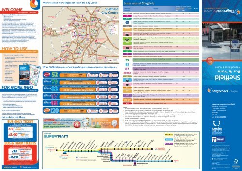
Where to catch your <strong>Stagecoach</strong> bus in the City Centre<br />
Fire and Police<br />
The Law Courts<br />
Netherthorpe<br />
Museum<br />
<strong>Sheffield</strong><br />
University<br />
Campus<br />
University<br />
of <strong>Sheffield</strong><br />
120<br />
Road<br />
123<br />
Police<br />
Headquarters<br />
88A<br />
The Pennine<br />
Centre<br />
88A<br />
Castle Ponds Forge/<br />
University of<br />
Fitzalan Sq.<br />
<strong>Sheffield</strong><br />
Cathedral Square<br />
City<br />
West<br />
Hall<br />
Street<br />
City Hall<br />
Town<br />
Hall<br />
52 Interchange<br />
<strong>Sheffield</strong><br />
Hallam<br />
University<br />
<strong>Sheffield</strong><br />
Rail Station<br />
88A 88A<br />
Superstore<br />
120123<br />
57<br />
20.20A<br />
52.69<br />
83.88<br />
25<br />
20.20A.25<br />
83 52.57 .69 83<br />
88<br />
83 .78 .87 87<br />
88 .88A<br />
83<br />
120 .123<br />
88<br />
265.N52<br />
43 .43A .44<br />
44A<br />
52 25. 43.<br />
.57.69<br />
43A<br />
79 .89.120<br />
44. 44A<br />
123 .265<br />
83 52. 57<br />
87. 88<br />
88A. 120<br />
123 120<br />
50<br />
44.44A<br />
79. 83<br />
120<br />
83. 88 25<br />
88A<br />
44<br />
25 .43<br />
44A .79 .83<br />
87 .88 .88A<br />
83<br />
88<br />
83<br />
88<br />
89<br />
X17<br />
A.<br />
88A.265<br />
52<br />
57.78.79. 83<br />
88. 88A<br />
20.20A<br />
69.83 .87<br />
88. 88A<br />
50A<br />
53.53A<br />
87. 88. 88A<br />
43.43<br />
83.87<br />
43A .44<br />
50 .50A<br />
53A<br />
120<br />
20.20A<br />
25.43.43A<br />
A.44<br />
78<br />
79<br />
87<br />
20. 20A<br />
215<br />
215<br />
215 20.20<br />
20<br />
20A<br />
215<br />
44.44A.87<br />
79<br />
A.25<br />
25<br />
X17<br />
X17<br />
25.43.43A<br />
89.215 .X17<br />
53<br />
88 .88 79<br />
A<br />
N52<br />
N52<br />
79<br />
N52<br />
N52 123<br />
N52<br />
0<br />
0<br />
400 yds.<br />
500 Metres<br />
BOLSOVER ST.<br />
52<br />
123.N52<br />
WESTERN BANK<br />
BROOK HILL<br />
GLOSSOP RD.<br />
UPPER HANOVER ST.<br />
LEAGRAVE<br />
RD.<br />
GELL<br />
ST.<br />
GLOSSOP ROAD<br />
HANOVER WAY<br />
ECCLESALL<br />
ROAD<br />
NETHERTHORPE ROAD<br />
HILL BROAD LANE<br />
PORTOBELLO STREET<br />
FITZWILLIAM STREET<br />
MOORE<br />
WEST STREET<br />
STREET<br />
CHARTER ROW<br />
ST. MARY’S GATE<br />
LONDON<br />
ROAD<br />
GIBRALTAR ST. WEST BAR<br />
SOUTH LANE<br />
TENTER<br />
STREET<br />
LEOPOLD ST.<br />
FURNIVAL<br />
GATE<br />
EYRE STREET<br />
QUEEN ST.<br />
PINSTONE ST.<br />
ST. MARY’S<br />
WEST BAR<br />
20.20A.25<br />
52.79.87<br />
120.123.N52<br />
BANK ST.<br />
SIDNEY<br />
STREET<br />
ARUN D E L<br />
BROWN<br />
STREET<br />
ROAD<br />
SHOREHAM STREET<br />
NURSERY STREET<br />
BRIDGE ST.<br />
ANGEL<br />
STREET<br />
GATE<br />
44<br />
89.215.X17<br />
A.57.69.79<br />
43.43A.44 MATILDA<br />
ST.<br />
HAYMARKET<br />
FLAT STREET POND STREET<br />
PATERNOSTER<br />
ROW<br />
LEADMILL<br />
STREET<br />
LEADMILL<br />
ROAD<br />
SUFFOLK ROAD<br />
50.50A<br />
53.53A<br />
QUEENS ROAD<br />
FARM ROAD<br />
WICKER<br />
BLONK<br />
STREET<br />
SHEAF STREET<br />
PARK SQ.<br />
PA RK<br />
SQ UARE<br />
ROAD<br />
SHREWSBURY<br />
<strong>Sheffield</strong><br />
City Centre<br />
DUKE STREET<br />
SHEFFIELD<br />
BROAD ST.<br />
<strong>Sheffield</strong> Station/<br />
<strong>Sheffield</strong> Hallam<br />
University<br />
TALBOT STREET<br />
120<br />
25<br />
120<br />
123<br />
GRANVILLE ROAD<br />
Granville Rd./<br />
The <strong>Sheffield</strong><br />
College The<br />
<strong>Sheffield</strong><br />
College<br />
PARKWAY<br />
CITY ROAD<br />
NORFOLK ROAD<br />
Hyde<br />
Park<br />
CRICKET INN RD.<br />
25<br />
<strong>Sheffield</strong><br />
Interchange<br />
50.50A.53.53A<br />
57.69.78.89<br />
120.123.215<br />
265.X17<br />
Flat Street<br />
43.43A.44.44A<br />
120<br />
123<br />
50 50A 53 53A<br />
Tram line<br />
and stop<br />
Produced by 30.4.12 www.fwt.co.uk<br />
We’ve highlighted some of our popular more frequent routes, take a look…<br />
To Stocksbridge<br />
To Stannington<br />
buses around <strong>Sheffield</strong><br />
buses run every (mins)<br />
service route MON - SAT SUN NOTES<br />
number day eves<br />
20/20A Hillsborough - Norwood - Pitsmoor - <strong>Sheffield</strong> - Heeley - Bole Hill - Hemsworth – 30 30 –<br />
25 Bradway - Woodseats - Heeley - <strong>Sheffield</strong> - Manor Park - Richmond - Woodhouse 20 – – –<br />
35A Chapeltown - Thorncliffe Industrial Estate 20 – – a<br />
<strong>Sheffield</strong> - Heeley - Woodseats - Dronfield - Dronfield Woodhouse - Gosforth - 30 60 60 –<br />
Unstone - Chesterfield<br />
43A <strong>Sheffield</strong> - Heeley - Woodseats - Dronfield - Hallowes 60 – – b<br />
44/44A <strong>Sheffield</strong> - Heeley - Woodseats - Batemoor - Coal Aston - Dronfield - Holmesdale - 30 – 60 c<br />
Unstone - Sheepbridge Industrial Estate - Chesterfield.<br />
50/50A Chesterfield - New Whittington - Birk Hill (50) / Marsh Lane (50A) - Eckington - 30 60 60 –<br />
Mosborough - Birley Moor - Manor Top - <strong>Sheffield</strong><br />
52 Hillsborough - Crookes - Broomhill - Western Bank - <strong>Sheffield</strong> - Attercliffe - Darnall - 4 15 10 d<br />
Handsworth - Woodhouse<br />
N52 Hillsborough - Crookes - Broomhill - Western Bank - <strong>Sheffield</strong> - Attercliffe - Darnall - – – – e<br />
Handsworth - Woodhouse<br />
53 Mansfield - Bolsover - Clowne - Renishaw - Eckington - Mosborough - Birley Moor - 120 – – –<br />
Manor Top - <strong>Sheffield</strong><br />
57 <strong>Sheffield</strong> - Hillsborough - Worrall - Oughtibridge - Wharncliffe Side - Deepcar - Stocksbridge – 60 60 –<br />
69 <strong>Sheffield</strong> - Meadowhall South - Rotherham – 60 60 –<br />
78 Chapeltown - Burncross - Foxhill - Wadsley Bridge - <strong>Sheffield</strong> 30 – – –<br />
Batemoor - Jordanthorpe - Hemsworth - <strong>Sheffield</strong> - Wadsley Bridge - Ecclesfield 10 – – f<br />
Bents Green - Hunters Bar - <strong>Sheffield</strong> - Norwood - Firshill - Southey Green - 10 30 30 –<br />
Parson Cross - Ecclesfield<br />
Lowedges - Greenhill - Abbeydale Road - <strong>Sheffield</strong> - Norwood - Ecclesfield - 10 – 30 –<br />
Chapeltown - High Green<br />
Bents Green - Hunters Bar - <strong>Sheffield</strong> - Burngreave - Firth Park - Shiregreen - 10 30 30 g<br />
Ecclesfield<br />
89 <strong>Sheffield</strong> - Heeley - Woodseats - Dronfield - Holmesfield - Chesterfield – 2 jnys – –<br />
120 Halfway - Crystal Peaks - Birley Moor - Manor Top - <strong>Sheffield</strong> - Hallamshire Hospital - 4 10-15 10-15 h<br />
Broomhill - Fulwood<br />
123 Crystal Peaks - Beighton - Woodhouse - Manor Top - <strong>Sheffield</strong> - Hallamshire Hospital - 30 – – –<br />
Endcliffe - Fulwood<br />
215 <strong>Sheffield</strong> - Hunters Bar - Bakewell – 2 jnys – –<br />
265 <strong>Sheffield</strong> - Burngreave - Ecclesfield - Chapeltown - Hoyland Common - Birdwell - 30 60 60 –<br />
Worsbrough Village - Barnsley<br />
X17 Matlock - Kelstedge - Chesterfield - Whittington Moor - Woodseats - <strong>Sheffield</strong> 30 – 2 hourly –<br />
STAGECOACH EXPRESS<br />
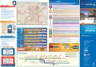
<strong>Supertram</strong><br />
Link (SL)<br />
Middlewood Tram stop - Oughtibridge - Wharncliffe Side - Deepcar - Stocksbridge 10 20 20 –<br />
SL2 Malin Bridge Tram stop - Deer Park Road - Nethergate - Acorn Drive 10 – – –<br />
Notes:<br />
a 20 minute frequency ends at 1930. Additional evening journeys between 2130 and 2230.<br />
b Additional peak journeys on Monday-Friday provide a 30 minute frequency. No Saturday service.<br />
c Route 44/44A provides a 30 minute frequency between <strong>Sheffield</strong>, Dronfield and Chesterfield. Service 44A serves Sheepbridge Industrial Estate.<br />
Sunday frequency operates between <strong>Sheffield</strong> and Dronfield only.<br />
d Joint service with First South Yorkshire. Saturdays joint frequency 5 mins. Sunday evenings joint frequency 15 minutes.<br />
e N52 operates 30 minutes during the early hours of Saturday and Sunday morning. Special fares apply.<br />
f Saturday frequency is every 12 minutes.<br />
g Serves High Green in the evening and Chapeltown in the evening and on Sunday only - route number 88A.<br />
h Joint service with First South Yorkshire. Daytime 4-5 minute frequency between Crystal Peaks and Hallamshire Hospital. 8-10 minute frequency to<br />
Fulwood and Halfway. Daytime Monday to Saturday <strong>Stagecoach</strong> operate Halfway to Hallamshire Hospital, First operate Fulwood to Crystal Peaks.<br />
After 1830 on Mondays to Saturdays and all day Sunday both operators buses run Fulwood to Halfway.<br />
Yellow Route<br />
Blue Route<br />
Purple Route<br />
Monday - Saturday: Trams run every 10 mins<br />
at peak times and every 20 mins off peak.<br />
Sunday: Trams run every 20 mins.<br />
Monday - Saturday: Trams run every 10 mins<br />
at peak times and every 20 mins off peak.<br />
Sunday: Trams run every 20 mins.<br />
Monday - Saturday: Trams run every 30 mins<br />
at peak times and every 20 mins off peak.<br />
Sunday: Trams run every 20 mins.<br />
stagecoachbus.com/sheffield<br />
from<br />
May<br />
2012<br />
Network <strong>Map</strong> & <strong>Guide</strong><br />
<strong>Sheffield</strong><br />
<strong>Bus</strong> & Tram<br />
stagecoachbus com/sheffield<br />
stagecoachbus.com/sheffield<br />
<strong>Stagecoach</strong> Yorkshire<br />
Customer Services<br />
Unit 4 Eldon Arcade<br />
Barnsley<br />
S70 2JP<br />
tel: 01226 202555<br />
travelsouthyorkshire.com<br />
We do our best to meet your expectations, but<br />
occasionally things can go wrong, if you feel we<br />
have failed you in some way, please write in the<br />
first instance to the address above.<br />
If you then remain unhappy with our response,<br />
you can write to<br />
The <strong>Bus</strong> Appeals Body, PO Box 119,<br />
Shepperton, TW17 8UX<br />
This is an independent organisation that will<br />
review your complaint.<br />
Please consider the environment<br />
and recycle this leaflet.<br />
Cover Photograph:<br />
Ponds Forge<br />
courtesy of <strong>Sheffield</strong> International Venues Ltd<br />
Information correct at time of going to print.<br />
May 2012
1<br />
2<br />
3<br />
4<br />
5<br />
6<br />
7<br />
8<br />
9<br />
More Hall Lane<br />
River Loxley<br />
10<br />
Rig gs High Ro ad<br />
Bingley Lane<br />
Redmires Road<br />
Blackbrook R oad<br />
Ma n c h e ster Road<br />
Owler Gate<br />
Lumb Lane<br />
Burnt Hill Lane<br />
Stopes Road<br />
A B C D E<br />
Kirk Edge Road<br />
Stubbing Lane<br />
Myers Lane<br />
Rivelin Valley R oad<br />
Lane<br />
La ne<br />
Crimicar<br />
57<br />
Unsliven<br />
Bridge<br />
Gree n<br />
C ross<br />
L ane<br />
Wharncliffe Side<br />
Primary School<br />
Wharncliffe<br />
Side<br />
Stocksbridge<br />
120 123<br />
Manchester Road<br />
Loxley Road<br />
Rowell Lane<br />
River Rivelin<br />
Manchester Road<br />
Crimicar Lane<br />
Manchester Rd.<br />
Hawthorne<br />
Avenue<br />
<strong>Sheffield</strong> Megarider<br />
boundary extends<br />
to Stocksbridge<br />
57<br />
SL<br />
Lodge<br />
Moor<br />
57.SL<br />
57<br />
SL<br />
Cockshutts Ln.<br />
Long L n.<br />
Acorn<br />
SL2<br />
G range Road<br />
Church St.<br />
Drive<br />
Long Lane<br />
Ringinglow Road<br />
Moorland Dr.<br />
River Don<br />
Woodhead Road<br />
S tat i on Ln.<br />
Langsett Road Sth.<br />
Haggstones Road<br />
Whitwell Ln.<br />
Church Oldfield Road<br />
St.<br />
Hallam<br />
Sports<br />
Centre<br />
57<br />
57<br />
to Stocksbridge<br />
See inset map above<br />
123<br />
120<br />
215 to<br />
Bakewell<br />
Loxley<br />
Sandygate Road<br />
Fulwood<br />
57<br />
Cedar Rd.<br />
Stone Moor Road<br />
Rodney Hill<br />
Roscoe Bank<br />
Hagg Lane<br />
Tom Lane<br />
Fulwood Road<br />
Baslow Road<br />
Middlewood Rd. Nth.<br />
Stockarth Ln.<br />
Worrall Road<br />
Greaves Lane<br />
Road<br />
SL<br />
Worrall<br />
Stannington<br />
SL<br />
83 88<br />
Victoria Rd.<br />
Coal P i t<br />
Deer Park<br />
Road<br />
Lane<br />
Halifax Ro ad<br />
O ug htibridge L a ne<br />
57<br />
Loxley Road<br />
Rivelin Valley Road<br />
Sandygate Road<br />
123<br />
120<br />
57.SL<br />
SL2<br />
Oakbrook Rd .<br />
88 A<br />
SL<br />
Bents Rd .<br />
Ecclesall Road South<br />
High Storrs Rd.<br />
QueenVictoria Rd.<br />
57<br />
Oughtibridge<br />
Hillsborough<br />
Bents Green<br />
Malin<br />
Bridge<br />
Bents Road/<br />
Ecclesall Road South<br />
Howbrook Ln.<br />
Ben Lane<br />
Hallowmoor Rd.<br />
Bole Hill Roa d<br />
Greysto nes Road<br />
Ecclesall Rd.<br />
Road South<br />
Abbeydale<br />
Berry<br />
Stannington Rd.<br />
Woodhead Road<br />
S k e w<br />
Manc hester Road<br />
Endcl i f f e<br />
Rustlings Road<br />
Dobcroft Road<br />
Whirlowdale Road<br />
Prospect<br />
Lane<br />
Langsett<br />
Stubbing House Ln.<br />
Avenue<br />
Ringinglow Road<br />
Fulwood Road<br />
Rd .<br />
A616<br />
Manchester Road<br />
Cockshot Lane<br />
Bolsterstone<br />
Wood Lane<br />
Ranmoor<br />
SL<br />
57<br />
Dykes Hall Road<br />
Hollinb erry Ln.<br />
Westwood New Road<br />
Middlewood Rd.<br />
SL2<br />
Crookes<br />
SL<br />
Carr Rd.<br />
Towne nd<br />
Hall Wood Road<br />
Penistone Roa d<br />
Hill Ln.<br />
Holme Ln.<br />
Wal kley Bank Rd.<br />
Crookes R d .<br />
Vale Rd.<br />
Main Street<br />
Fox Hill Road<br />
Fox Hill Rd.<br />
Abbeydale Road South<br />
Twentywell Lane<br />
Bradway Rd.<br />
Rod Moor Rd.<br />
L a ne<br />
Thompso n Hill<br />
52<br />
N52<br />
Nort hfield Rd.<br />
Penistone Road<br />
Springvale Rd.<br />
52<br />
N52<br />
South Road<br />
A b b ey Lane<br />
Lane<br />
Bracken Hill<br />
Avenue<br />
Wilcox Rd.<br />
Halifax Road<br />
H alifax Road<br />
Penistone<br />
North<br />
Rd.<br />
Clarkeho<br />
Road<br />
use<br />
Carter Knowle Road<br />
Spri n gfield Rd.<br />
Wortley<br />
Foster<br />
87<br />
Western<br />
Royal<br />
Hallamshire<br />
123 Hospital<br />
123<br />
Way<br />
Cowper<br />
Bank<br />
Road<br />
Springwood<br />
Ecclesall<br />
Road<br />
Psalter Lane<br />
Langsett<br />
Road<br />
Hemper Lane<br />
Soughley Lane<br />
Manchester Road<br />
88A<br />
Greengate Ln.<br />
Greenhill<br />
Elliott<br />
Whitley Lane<br />
Wheel Lane<br />
Deerlands<br />
Herries<br />
Glossop<br />
Road<br />
Creswick Ln.<br />
Wordsworth Ave.<br />
Abbeydale Road<br />
A616<br />
Rd.<br />
Chaucer Rd.<br />
Mortomley<br />
Lane<br />
School<br />
Worra l l<br />
Ro a d<br />
Lane<br />
Ave.<br />
Road<br />
Penistone Road<br />
Abbeydale Rd.<br />
Parkway<br />
Bur ncross Road<br />
Yew Lane<br />
Neepsend Ln.<br />
The D a le<br />
Lowedges Road<br />
River Don<br />
Junction 36<br />
Wordsworth Avenue<br />
So uthey Gre en Road<br />
Infirmary<br />
Blac k burn Drive<br />
Ad lington Road<br />
<strong>Sheffield</strong> Wednesday F.C.<br />
Hillsborough<br />
Hutcliffe<br />
Wood Rd.<br />
123<br />
Bocking<br />
Lane<br />
Road<br />
120<br />
88 83<br />
88A<br />
215<br />
Bockin g Lane<br />
A616<br />
Thorncliffe<br />
Industrial<br />
Estate<br />
Be v a n W ay<br />
Avenue<br />
Greenhill<br />
Chapel Road<br />
Holgate Ave.<br />
Chesterfield Road Sth.<br />
L ound<br />
Side<br />
Junction<br />
35A<br />
Deerlands Avenue<br />
Shirecliffe Rd.<br />
Pitsmoor Rd.<br />
Rutland Road<br />
London Road<br />
Chesterfield Roa<br />
En d<br />
La n e<br />
Meadowhead<br />
Cart Road<br />
Church St.<br />
Bramall Ln.<br />
Derbyshire Lane<br />
M1 Motorway<br />
High Street<br />
Ecclesfield Rd.<br />
Mill Rd.<br />
Lindsay Avenue<br />
C rowder Rd.<br />
Moonshine Lane Longley Ave.<br />
C hesterfield Rd.<br />
35A<br />
Ecclesfield<br />
School<br />
Monteney Road<br />
Warren Lane<br />
West<br />
Firshill<br />
Crescent<br />
Rock St.<br />
Warminster Road<br />
Myrtle<br />
Bochum<br />
Lees Hall Road<br />
Sheffie l d Road<br />
White Lane<br />
Chapeltown<br />
Station Road<br />
Cowley Lane<br />
Nether Lane<br />
Common<br />
Elm Lane<br />
Burngreave Rd.<br />
Nursery St.<br />
88A<br />
83<br />
88. 88A<br />
87<br />
83 88<br />
215<br />
83<br />
88<br />
Brincliffe<br />
20.20A<br />
25.43.43A<br />
44.44A<br />
89.X17<br />
88A<br />
215<br />
20<br />
Abbeydale<br />
SL<br />
57<br />
Walkley<br />
87<br />
88A<br />
78<br />
20<br />
78<br />
79<br />
78<br />
87 88A<br />
78<br />
20A<br />
83<br />
20 Hillsborough<br />
Leisure Centre<br />
20A<br />
78<br />
79 20 20A 52 N52<br />
Hillsborough<br />
Interchange<br />
78<br />
79<br />
20<br />
20.20A<br />
25.43.43A<br />
44.44A.87<br />
25<br />
83<br />
35A<br />
87<br />
88A<br />
78<br />
Grenoside Ecclesfield<br />
Broomhill<br />
Dore<br />
57.SL<br />
to Wharncliffe Side<br />
See map below<br />
Middlewood<br />
Leppings<br />
Lane<br />
Hillsborough<br />
Park<br />
Malin<br />
Bridge<br />
Beauchief<br />
Bamforth<br />
Street<br />
87<br />
Burncross<br />
Langsett Road/<br />
Primrose View<br />
Greenhill<br />
Tesco<br />
87<br />
High<br />
Green<br />
79<br />
Shirecliffe<br />
Infirmary<br />
Road<br />
Shalesmoor<br />
Woodseats<br />
79<br />
83<br />
25.43.43A<br />
44.44A<br />
89.X17<br />
87<br />
88A<br />
265<br />
83<br />
Parson Cross<br />
Southey<br />
Green<br />
University of<br />
<strong>Sheffield</strong><br />
For enlargement of<br />
<strong>Sheffield</strong> City Centre<br />
see inset map overleaf<br />
20 20A<br />
Norwood<br />
20A<br />
20A<br />
83<br />
87<br />
89<br />
X17<br />
Chapeltown Rd.<br />
35A<br />
79<br />
20<br />
20A<br />
87<br />
Spital Hill<br />
East Bank Rd.<br />
Road<br />
Cross Hill<br />
Nor t on L a n e<br />
Parkway<br />
Jordanthorpe Parkway<br />
S h e f field<br />
High Greave<br />
Cowley Hill<br />
Barnsley<br />
Scott Rd.<br />
Hartley Brook Road<br />
Hemsworth Road<br />
Ro a d<br />
Green Lane<br />
Road<br />
Road<br />
Spencer Road Gleadless<br />
Dyche La.<br />
265<br />
The<br />
87<br />
265<br />
78<br />
Longley Lane<br />
Northern<br />
General<br />
Hospital<br />
265<br />
88<br />
83<br />
Barnsley Rd.<br />
Herries Road<br />
Barnsley<br />
<strong>Sheffield</strong> United F.C.<br />
Bramall Lane<br />
20<br />
Graves<br />
Park<br />
79<br />
44<br />
44A<br />
79<br />
265 to Barnsley<br />
Chapeltown,<br />
Norfolk Arms<br />
Kirby Lane<br />
M1 Motorway<br />
Chapeltown<br />
87<br />
Pitsmoor<br />
83<br />
88<br />
88A<br />
265 20<br />
20A<br />
Smithywood<br />
Drive<br />
<strong>Sheffield</strong> City Centre<br />
Town<br />
Hall<br />
<strong>Sheffield</strong><br />
Hallam<br />
University<br />
Interchange<br />
79<br />
79<br />
<strong>Sheffield</strong><br />
Rail Station<br />
79<br />
The <strong>Sheffield</strong><br />
College<br />
Heeley<br />
Sicey Avenue<br />
Hucklow Rd.<br />
Park Grange<br />
Road<br />
Blackstock<br />
Broadcarr Road<br />
F G<br />
and Chesterfield<br />
A 25 B C D (43A full route)<br />
50.50A.70.71 to Chesterfield<br />
E F G<br />
Junction<br />
35<br />
Ecclesfield Road<br />
88<br />
88A<br />
Sicey Avenue<br />
88<br />
88A<br />
265<br />
88<br />
88A<br />
Firth Park Roa d<br />
Petre Street<br />
Carlisle Street East<br />
Road Manor Ln.<br />
City Rd.<br />
Road<br />
Blackstock Rd.<br />
The Barrow<br />
Coach Road<br />
Hemsworth<br />
20 20A<br />
20<br />
20A<br />
79<br />
Hesley Lane<br />
Bellhouse Road<br />
Bar nsley<br />
Owler Lane<br />
Savile Street East<br />
N52<br />
69<br />
52<br />
( <strong>Sheffield</strong> Outer Ring Rd.)<br />
S h ire gree n Lane<br />
Attercliffe Road<br />
Maltravers Ro a d<br />
79<br />
Harley<br />
Thorpe<br />
Hesley<br />
Firth<br />
Park<br />
Grimesthorpe<br />
Hyde Cricket<br />
Park Inn Road<br />
Park Grange<br />
Croft<br />
Park<br />
Hill<br />
Arbourthorne<br />
Road<br />
Manor Ln.<br />
Eastern Avenue<br />
Jordanthorpe<br />
Road<br />
East Bank Road<br />
Upper Wortley Road<br />
Leighton Road<br />
Brook Hill<br />
Concord<br />
Sports<br />
Centre<br />
25<br />
50.50A<br />
53<br />
120<br />
123<br />
Grange Lane<br />
Ecclesfield Road<br />
Brightside<br />
Brightside Lane<br />
Holywell Road<br />
U pwell St.<br />
Newhall<br />
City Road<br />
Arbourthorne<br />
Gleadless<br />
River Don<br />
Harborough Av.<br />
Attercliffe Common<br />
Sh effield Parkway<br />
Mano r Pk. Ce n tre<br />
Manor<br />
Park<br />
Gleadless<br />
Shiregreen<br />
25<br />
87<br />
Lowedges Road<br />
<strong>Sheffield</strong> Megarider<br />
79<br />
79 <strong>Sheffield</strong> Megarider<br />
boundary on<br />
service 89<br />
Dronfield, Carr Lane<br />
Longford Road<br />
boundary on service X17<br />
is Norton Hotel<br />
X17 to Chesterfield<br />
Bradway and Matlock<br />
43.43A.89<br />
to Dronfield<br />
44.44A<br />
to Dronfield<br />
and Chesterfield<br />
<strong>Sheffield</strong> Megarider<br />
boundary extends on<br />
service 43, 44 & 44A to<br />
Dronfield, The Three Tuns PH<br />
Nunnery<br />
Square<br />
Spring<br />
Lane<br />
Herdings<br />
Park<br />
Attercliffe<br />
Woodbourn<br />
Road<br />
Manor Top/<br />
Elm Tree<br />
Gleadless<br />
Common<br />
Road<br />
M1 Motorway<br />
Janson St.<br />
Motorpoint<br />
Arena<br />
Prince Of Wales Rd.<br />
Hollinsend<br />
Herdings/<br />
Leighton Road<br />
Ridgeway Road<br />
Hollinsend Rd.<br />
Meado w h all Way<br />
Attercliffe<br />
Common<br />
Broughton Ln.<br />
Darnall Road<br />
Staniforth Road<br />
Harborough Ave.<br />
<strong>Sheffield</strong> Rd.<br />
Greenland Road<br />
Beaumont Road Hastillar Road South<br />
North<br />
KEY<br />
Main <strong>Bus</strong> Routes<br />
20.20A<br />
Evenings and Sundays Only<br />
Meadowhall<br />
Interchange<br />
Road<br />
Barrow<br />
Road<br />
Meadowhall<br />
Shopping Mall<br />
Weedon St.<br />
Ice<strong>Sheffield</strong><br />
Arena/<br />
69 Don Valley<br />
Stadium<br />
<strong>Sheffield</strong> Eagles R.L.F.C.<br />
Don Valley Stadium<br />
Woodhouse<br />
Mansfield Road<br />
Gleadless<br />
Townend<br />
White<br />
Lane<br />
Cinema<br />
52<br />
N52<br />
25<br />
25<br />
35A<br />
43.43A<br />
44.44A<br />
50.50A.53<br />
52.N52<br />
57<br />
Evenings and Sundays Only<br />
Darnall<br />
Junction<br />
34<br />
Meadowhall<br />
69<br />
Prince Of Wales Rd.<br />
Fox Lane<br />
Shepcote La ne<br />
Bowling Alley<br />
Valley<br />
Centertainment<br />
Hollinsend<br />
South<br />
Tinsley<br />
Carbrook<br />
Main Rd.<br />
Meadowhall Road<br />
Meadow Bank Ro a d<br />
Mosborough<br />
Parkway<br />
Richmond Road<br />
50<br />
50A<br />
53<br />
120<br />
B irley<br />
Europa<br />
Handsworth<br />
Road<br />
St. Lawrence<br />
Road<br />
Junction<br />
34<br />
Greenland<br />
Darnall<br />
Richmond<br />
Richmond Park Road<br />
Normanton Hill<br />
123<br />
Linley Lane<br />
Link<br />
Birley Moor Road<br />
Bawtry Road<br />
Richmond Rd.<br />
Silk s t o n e R oad<br />
Lane<br />
Main Road<br />
Handsworth Road<br />
<strong>Sheffield</strong> Parkway<br />
Mosborough Parkway<br />
Stradbroke Ro a d<br />
Birley<br />
Lane<br />
69<br />
Evenings and Sundays Only<br />
70.71<br />
78<br />
79<br />
83<br />
87<br />
88<br />
88A<br />
Evenings only to High Green<br />
Sundays only to Chapeltown<br />
89<br />
Evenings Only<br />
INDEX TO PLACES<br />
B<br />
Bradway B10<br />
Brightside D5<br />
Brincliffe B8<br />
Broomhill B7<br />
Burncross<br />
C<br />
C3<br />
Chapeltown D3<br />
Crookes<br />
D<br />
B7<br />
Darnall<br />
E<br />
E7<br />
Ecclesfield<br />
F<br />
C4<br />
Firth Park D5<br />
Frecheville F9<br />
Fulwood<br />
G<br />
A8<br />
Greenhill C10<br />
Grimesthorpe D6<br />
St. Lawrence<br />
Road<br />
<strong>Sheffield</strong> Road<br />
69<br />
Tinsley<br />
<strong>Sheffield</strong><br />
City Airport<br />
52<br />
N52<br />
High Lane<br />
Wilton Ln.<br />
M1 Motorway<br />
Europa<br />
<strong>Sheffield</strong><br />
Dyke Vale Road<br />
Occupation Lane<br />
Ferham Rd.<br />
Bonet Lane<br />
River Don<br />
Link<br />
Orgreave<br />
Lane<br />
Bawtry Road<br />
Brins worth Road<br />
Poplar Way<br />
Retford Road<br />
Handsw orth<br />
Grange Rd.<br />
Road<br />
<strong>Sheffield</strong> Road<br />
Beaver Hill Rd.<br />
25<br />
Brinsworth Ln.<br />
52123N52<br />
25 25<br />
Frecheville<br />
Mosborough Parkway<br />
Birley Spa Lane<br />
Beighton Road<br />
Donets k Way<br />
Moor Valley Mosborough Moor<br />
50<br />
50A<br />
53<br />
120<br />
69<br />
Handsworth<br />
Birley Moor<br />
Road<br />
Main bus routes in & around<br />
<strong>Sheffield</strong><br />
Hackenthorpe<br />
120<br />
123<br />
123<br />
Certain Journeys Only<br />
215<br />
Evenings Only<br />
265<br />
SL<br />
SL2<br />
X17<br />
Woodhouse<br />
Hackenthorpe<br />
Mosborough<br />
Rotherham<br />
Central<br />
Centenary Way<br />
Whitehill Rd.<br />
52<br />
N52<br />
Old Retford Rd.<br />
Donetsk<br />
Way<br />
25<br />
Centenary Way<br />
Whitehill Lane<br />
Woodhouse<br />
Badger Rd.<br />
Hill Rd.<br />
25 Woodhouse<br />
Beaver<br />
Station<br />
Moss Way<br />
Moss Way<br />
High St.<br />
River Rother<br />
Retford Road<br />
52N52<br />
Woodhouse<br />
Cross Street<br />
Spa<br />
Lane<br />
120<br />
Moss<br />
Way<br />
B eig h ton Road<br />
Gashous e Lane<br />
Road<br />
69<br />
123<br />
West Bawtry Road<br />
Junction<br />
33<br />
52<br />
Lane<br />
Furn ace<br />
Mosborough<br />
Crystal Peaks<br />
120 Calls at<br />
Crystal Peaks<br />
Thorpe<br />
Green<br />
69<br />
Canklow<br />
Parkway<br />
Ochre<br />
Dike<br />
Owlthorpe<br />
Greenway<br />
Westfield<br />
Northway<br />
Westfield<br />
Sports Centre<br />
50<br />
50A<br />
53 120<br />
Halfway<br />
Moss<br />
Way<br />
Darnall<br />
H<br />
Hackenthorpe F9<br />
Halfway F10<br />
Handsworth F8<br />
Harley D2<br />
Heeley D8<br />
High Green C2<br />
Hillsborough B6<br />
Hollinsend<br />
L<br />
E9<br />
Lodge Moor A7<br />
Loxley<br />
M<br />
A6<br />
Malin Bridge B6<br />
Manor Park D7<br />
Mosborough<br />
N<br />
F10<br />
Newhall D6<br />
Norwood<br />
O<br />
C5<br />
Oughtibridge B4<br />
<strong>Sheffield</strong> Megarider<br />
boundary extends to<br />
Eckington Marsh Lane<br />
& Birk Hill Estate<br />
Station Road<br />
50<br />
50A<br />
53<br />
Rotherham<br />
Ro t herway<br />
<strong>Sheffield</strong> Rd.<br />
<strong>Sheffield</strong> Road<br />
N52<br />
Woodhouse<br />
Crystal<br />
Peaks<br />
Waterthorpe<br />
Halfway<br />
Drive<br />
Rotherham<br />
Interchange<br />
Lane<br />
53 to Mansfield<br />
<strong>Sheffield</strong> Megarider zone<br />
Route terminus<br />
Railway line and station<br />
Tram line and station<br />
<strong>Sheffield</strong> Interchange<br />
Hospital<br />
Produced by 4.5.12 www.fwt.co.uk<br />
P<br />
Park Hill D7<br />
Parson Cross C5<br />
Pitsmoor<br />
R<br />
D6<br />
Ranmoor B7<br />
Richmond E8<br />
Rotherham<br />
S<br />
G4<br />
<strong>Sheffield</strong> D7<br />
Shirecliffe C6<br />
Southey Green<br />
W<br />
C5<br />
Walkley B7<br />
Waterthorpe G9<br />
Wharncliffe Side A4<br />
Woodhouse G8<br />
Woodseats C9<br />
Worrall A5<br />
123<br />
Robin Lane<br />
Thorpe<br />
Drive<br />
120<br />
120<br />
70<br />
71<br />
120<br />
Beighton/<br />
Drake House Lane<br />
R otherham Road<br />
Way<br />
70<br />
71<br />
Eckington<br />
Waterthorpe<br />
Westfield<br />
Halfway<br />
Station Rd.<br />
Morrisons<br />
Superstore<br />
1<br />
2<br />
3<br />
4<br />
5<br />
6<br />
7<br />
8<br />
9<br />
70.71 to<br />
Killamarsh<br />
10<br />
<strong>Sheffield</strong> <strong>Bus</strong> <strong>Map</strong> & <strong>Guide</strong> 04/05/2012 16:41 Page 2