WATER RESOURCES OF CALIFORNIA 497 RUNOFF Estimated mean seasonal natural run<strong>of</strong>f <strong>of</strong> the Lahontan Area for the 53-year period from 1894-95 to 1946-47 is 3,177,000 acre-feet, or 4.5 percent <strong>of</strong> total surface run<strong>of</strong>f <strong>of</strong> the <strong>State</strong>. Minimum seasonal run<strong>of</strong>f amounting to 930,000 acre-feet occurred in 1923-24, and the maximum, totalling 7,070,000 acre-feet, in 1906-07. <strong>Water</strong> supply during each year <strong>of</strong> the 10-year period from 1923-24 to 1932-33, except 1926-27, was less than the 53-year seasonal mean, and the average was only 63 percent <strong>of</strong> this long-time mean. Snow falls on large portions <strong>of</strong> the tributary drainage <strong>of</strong> the Lahontan Area. Consequently, a substantial portion <strong>of</strong> seasonal run<strong>of</strong>f is delayed until late spring and early summer. For Truckee River, a typical Lahontan Area stream that flows from the Sierra Nevada, snow melt contributes 95 percent <strong>of</strong> seasonal run<strong>of</strong>f. Minimum run<strong>of</strong>f in the Area occurs from August to October, inclusive. On Truckee River run<strong>of</strong>f during these months is only 4.9 percent <strong>of</strong> the seasonal total. Stream gaging stations in the Lahontan Area, are listed in Table 71 together with the average, maximum and minimum seasonal run<strong>of</strong>f for stations with more than 10 years <strong>of</strong> record. Longest available records <strong>of</strong> stream flow are for Truckee River at or near the state line, and for Owens River near Round Valley. The record for the 'rruckee has been maintained since September, 1899, and that for Owens River since August, 1903, except from October, 1923, to March, 1927. Records for these two stations are no longer published by the Geological Survey, but may be secured from the Federal Court <strong>Water</strong>master for Truckee River and from the <strong>Department</strong> <strong>of</strong> <strong>Water</strong> and Power <strong>of</strong> the City <strong>of</strong> Los Angeles for Owens River. Estimated mean seasonal natural run<strong>of</strong>f <strong>of</strong> the 53 years from 1894-95 to 1946-47, shown in Table 72, has been prepared i:r{ the same manner as corresponding tables in preceding chapters. For stations with partial records, mean seasonal run<strong>of</strong>f shown is the mean <strong>of</strong> estimated natural flow for each season <strong>of</strong> the 53-year period. At locations where records are not available, only directly derived long-time mean estimates are given. Estimates <strong>of</strong> seasonal natural run<strong>of</strong>f <strong>of</strong> main stream and tributary basins having records, presented in Table 73, were made in accordance with principles outlined in Chapter III. Estimates <strong>of</strong> run<strong>of</strong>f from drainage basins where records were not available were made by comparison with run<strong>of</strong>f from other basins. In deriving the 53-year seasonal mean for unmeasured streams discharging into lakes in the northern portion <strong>of</strong> the Area, inflow to a lake, computed from records <strong>of</strong> lake levels, was taken to be run<strong>of</strong>f <strong>of</strong> the stream during the period <strong>of</strong> record. A relationship was then established with an adjacent stream, and the missing record was estimated by the third method <strong>of</strong> restoring missing records described in Chapter III. Estimates <strong>of</strong> mean seasonal run<strong>of</strong>f for streams or basins for which no records <strong>of</strong> any type existed were made by comparison with run<strong>of</strong>f <strong>of</strong> adjacent areas, on the basis <strong>of</strong> geographical, geological and meteorological conditions. The portion <strong>of</strong> mean seasonal run<strong>of</strong>f that was estimated for the Lahontan Area approximates 1,183,000 acre-feet, the remaining 1,994,000 acre-feet being based on records. An unusual feature <strong>of</strong> the natural flow estimate for Truckee River, in Table 73, is the occurrence in several years <strong>of</strong> negative values in esti-
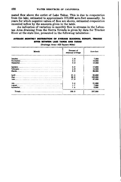
498 WATER RESOURCES OF CALIFORNIA mated flow above the outlet <strong>of</strong> Lake Tahoe. This is due to evaporation from the lake, estimated to approximate 375,000 acre-feet seasonally. In years for which negative values <strong>of</strong> flow are shown, estimated evaporation exceeded inflow by the amounts given in the table. An indication <strong>of</strong> variation in monthly flow in streams in the Lahontan Area draining from the Sierra Nevada is given by data for Truckee River at the state line, presented in the following tabulation: AVEIlAGI MONnaT DlSRlaunoN Of AVEIlAGI SIA50NAL RUNOFF, TRUCKlE RIVER IUWIEN LAKE TAHOI AND FARAD (Drainage Area-425 Squar. Miles) October_•.. 00. __ November.. _ December_" _ laouary__ • . __ February... _ March. __ . _ . ---- ::1 -------1 Pereellt<strong>of</strong> llea80naJ average Acre-f""t 1.8 7,000 2.5 10.000 3.2 13,000 4.2 17,000 4.8 19.000 9.8 311,000 April.. May June __ • _ _ _ 21.4 26.8 17.0 85,000 106.000 67,000 5.4 21,000 1.7 7,000 1.4 6.000 E::;,;;·.· ••·•• •··•···•·.•• •· .••.··•·· •• ·•· ••• ··I------;------ Totals __ . _ _ . _. 100.0 397,000
- Page 11 and 12:
CHAPTER I. INTRODUCTION WATER A MAJ
- Page 15 and 16:
WATER RESOURCES OF CALIFORNIA 21 De
- Page 18 and 19:
24 WATER RESOURCES OF CALIFORKIA No
- Page 21 and 22:
WATER RESOURCES OF CALrFORNIA 27 an
- Page 23:
CHAPTER II. SUMMARY The purpose of
- Page 35:
WATER RESOURCES OF CALIFORNIA 41 ar
- Page 41:
48 WATER RESOURCES OF CALIFORNIA de
- Page 51:
REDWOOD mGHWAY-KORTH COASTAL .ARE.\
- Page 77:
WATER RESOURCES OF CALIFORNIA 85 TA
- Page 107:
114 WATER RESOPRCES OF CALIFORXIA R
- Page 128:
COABTAL TERP.AOf-CEXTRAI.. COASTAL
- Page 144:
152 WATER RESOURCES OF CALIFORNIA T
- Page 166:
li4 WATER RESOURCES OF CALIFORKIA s
- Page 184:
WATER RESOURCES OF CALIFORNIA 191 T
- Page 206:
WATER RESOURCES OF CALIFORNIA 213 T
- Page 339:
346 WATER RESOURCES OF CALIFORNIA R
- Page 407:
414 WATER RESOURCES OF CALIFORNIA f
- Page 458: WATER RESOURCES OF CALIFORNIA 465 c
- Page 476: Number on Plate 2 12 13 14-1 14-2 1
- Page 517 and 518: JOSHUA TREES-COLORADO DESERT AREA (
- Page 519 and 520: 526 WATER RESOURCES OF CALIFORNIA N
- Page 523: 530 WATER RESOURCES OF CALIFORNIA F
- Page 536: APPENDIX A RECLAMATION OF SEWAGE AN
- Page 553:
Table TABLE OF CONTENTS Page 1. Alp
- Page 608:
APPENDIX D GROUND-WATER STORAGE CAP
- Page 614:
WATER RESOURCES OF CALIFORNIA 623 r
- Page 626:
APPENDIX E COLORADO RIVER Diversion