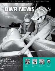
Bulletin 1.pdf - California Department of Water Resources - State of ...
Bulletin 1.pdf - California Department of Water Resources - State of ...
Bulletin 1.pdf - California Department of Water Resources - State of ...

You also want an ePaper? Increase the reach of your titles
YUMPU automatically turns print PDFs into web optimized ePapers that Google loves.
308 WATER RESOURCES OF CALIFORNIA<br />
Sierra Nevada, and Cottonwood, Stony, Cache, and Putah Creeks which<br />
drain the coastal ranges west <strong>of</strong> the Sacramento Valley. San Joaquin<br />
River flows into the Sacramento from the south and its principal tributaries,<br />
the Cosumnes, Mokelumne, Calaveras, Stanislaus, Tuolumne, and<br />
Merced Rivers, are all from the Sierra Nevada. Kings, Kaweah, Tule, and<br />
Kern Rivers also drain from the Sierra Nevada but into Tulare Lake,<br />
rather than northward into San Joaquin River. A portion <strong>of</strong> the flood<br />
flow <strong>of</strong> Kings River is tributary to San Joaquin River, by way <strong>of</strong> Fresno<br />
Slough, and in times past during periods <strong>of</strong> flood Tulare Lake has overflowed<br />
into San Joaquin River. No large streams enter San Joaquin<br />
Valley from the coastal ranges. Areas <strong>of</strong> drainage basins in the Central<br />
Valley Area are listed in Table 53.<br />
PRECIPITATION<br />
It is difficult to generalize regarding precipitation <strong>of</strong> the Central<br />
Valley Area in terms <strong>of</strong> "light," "moderate," or"heavy." Storms<br />
sweeping in from the ocean over the coastal ranges and across the Central<br />
Valley are influenced by changes in elevation. As elevation is gained on<br />
the west slope <strong>of</strong> the coastal ranges precipitation increases. Inversely, it<br />
diminishes down the east slope. In general, little variation is registered<br />
as storms pass eastward across the Central Valley floor, but as they<br />
ascend the west slope <strong>of</strong> the Sierra Nevada precipitation again increases,<br />
reaching the maximum as the crest is approached. Then, as storms pass<br />
over the crest and down the east side, it again decreases.<br />
Heavy snowfall is a winter feature <strong>of</strong> the Sierra Nevada at elevations<br />
above about 3,000 feet in the northern portions and above about<br />
4,000 feet in the south. Its depths are exceeded in few parts <strong>of</strong> the United<br />
<strong>State</strong>s. In March, 1907, and again in 1911, 308 inches <strong>of</strong> snow was measured<br />
at Donner Summit. During the seasons <strong>of</strong> 1880 and 1890, as estimated<br />
from records <strong>of</strong> marks at stations on the transcontinental railroad<br />
crossing the Sierra Nevada, the fall was 370 inches. These figures are<br />
given for snow depths at time <strong>of</strong> measurement. Accretions during a season<br />
have exceeded 800 inches at Tamarack, at an elevation <strong>of</strong> 8,000 feet<br />
in Alpine County. The Cascade Range on the Olympic Peninsula in<br />
WashingtQn is the only area in the United <strong>State</strong>s to record greater<br />
depths. Snow in measurable quantities on floors <strong>of</strong> the Sacramento and<br />
San Joaquin Valleys is rare.<br />
Two hundred and ninety-nine precipitation stations with records <strong>of</strong><br />
10 years or more are being maintained in the Central Valley Area. They<br />
are listed in Table 54, together with mean, maximum and minimum seasonal<br />
precipitation. These stations are at elevations ranging from sea level<br />
to 8,000 feet. The longest record is for the station at Sacramento, which is<br />
unbroken since 1849. Precipitation stations in the Central Valley Area<br />
with continuous recorders are listed in Table 55. Stations with records <strong>of</strong><br />
less than ten years are listed in Table 56.<br />
Precipitation in the Area decreases progressively from north to<br />
south. Mean seasonal rainfall on the floor <strong>of</strong> Sacramento Valley between<br />
the Sacramento-San Joaquin Delta and Red Bluff varies in general from<br />
15 inches to 25 inches. On the San Joaquin Valley floor, which is bounded<br />
by a seasonal isohyet <strong>of</strong> 15 inches, minimum seasonal precipitation <strong>of</strong><br />
less than five inches may occur in the Tulare Lake and Buena Vista Lake<br />
sections. A minimum seasonal total <strong>of</strong> 0.57 inch was recorded at Rio