Pony Path, Tŷ Nant - Snowdonia National Park
Pony Path, Tŷ Nant - Snowdonia National Park
Pony Path, Tŷ Nant - Snowdonia National Park

You also want an ePaper? Increase the reach of your titles
YUMPU automatically turns print PDFs into web optimized ePapers that Google loves.
<strong>Pony</strong> <strong>Path</strong>, <strong>Tŷ</strong> <strong>Nant</strong><br />
© Crown copyright. All rights reserved. 100022403, 2011<br />
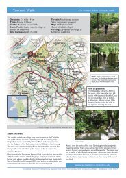
Distance: 6 miles (10km) (there and back)<br />
Ascent: 2,384 feet (727 metres)<br />
Time: About 5 hours (there and back)<br />
Grade: Mountain Walk<br />
Start / Finish: <strong>Tŷ</strong> <strong>Nant</strong> Car <strong>Park</strong> (SH 697 153)<br />
Relevant Map: Ordnance Survey Explorer OL 23 (Cadair Idris & Llyn Tegid)<br />
<strong>Park</strong>ing<br />
The path starts at the entrance to <strong>Tŷ</strong> <strong>Nant</strong> farm (SH 697153) on the ‘Cader’ road<br />
about 3 miles out of Dolgellau. There is a <strong>National</strong> <strong>Park</strong> car park and toilet block at<br />
Pont Dyffrydan almost opposite.<br />
© 2011 <strong>Snowdonia</strong> <strong>National</strong> <strong>Park</strong> Authority
<strong>Pony</strong> <strong>Path</strong>, <strong>Tŷ</strong> <strong>Nant</strong><br />
The <strong>Pony</strong> <strong>Path</strong> from Ty <strong>Nant</strong> is the main footpath up Cader Idris from the Dolgellau side of the mountain.<br />
It is a reasonably safe and easy route, which also offers the most rewarding views.<br />
The Fox’s <strong>Path</strong> rises from the Gwernan hotel. This path requires walkers to walk along a very steep and<br />
loose scree slope above Llyn y Gader in order to reach the summit. Extreme care is needed when undertaking<br />
this path, especially when it's windy, wet or when the stones are covered with ice and snow.<br />
Descending this path requires very good physical fitness and we do not recommend anyone who are not<br />
experienced on these kinds of terrain to choose this path.<br />
The Route<br />
1. The path starts at the entrance to <strong>Tŷ</strong> <strong>Nant</strong> farm. As you<br />
walk from the car park, you will see <strong>Tŷ</strong> <strong>Nant</strong> farmhouse on<br />
your left, and beyond it the Cader Idris Ridge with, from left<br />
to right, Mynydd Moel, Pen y Gader - the summit (2,927ft,<br />
893m) and Cyfrwy (The Saddle), with the conspicuous notch<br />
which is Idris’ Table.<br />
2. Follow the track up to <strong>Tŷ</strong> <strong>Nant</strong>, and pass through a kissing<br />
gate beside the farmhouse. Soon you cross a concrete bridge<br />
over a stream and pass through a mixed woodland of birch,<br />
hazel, sycamore, ash and hawthorn. Woodland is useful on a<br />
mountain farm as it provides shelter for stock in bad<br />
weather. However, constant grazing by sheep prevents young<br />
trees from growing, and this has resulted in a serious decline<br />
in <strong>Snowdonia</strong>’s native woodlands. The <strong>National</strong> <strong>Park</strong> Authority<br />
is taking measures to encourage the conservation of<br />
existing and the creation of new woods.<br />
3. The path is rocky and climbs very gently. This section, as<br />
most of the path up Cader Idris, has suffered badly from<br />
erosion in the past. Slates have been sunk across the path to<br />
prevent hill-slip and to drain off surface water.<br />
4. Shortly you will come to three large sweet chestnut trees<br />
where you must turn right (marker post). Pass through a<br />
kissing gate and cross the stream by the stone bridge.<br />
Presently the path starts to climb steeply up a grassy<br />
hillside.<br />
5. Passing through a gap in a dry-stone wall by a stream,<br />
you will notice that the terrain has become more open. The<br />
only trees around are dwarfed and twisted hawthorns. This is<br />
largely because the climate becomes harsher the higher up<br />
the mountain you go, and fewer species are able to stand<br />
such adverse conditions.<br />
6. Keeping to the steps built into the slope ahead, you will<br />
eventually pass through a gate (please close) and over a<br />
small bridge. To your left are the impressive cliffs of Cyfrwy.<br />
Notice that trees have virtually disappeared at this altitude.<br />
7. Soon you will come to another gate in the wall. As you<br />
pass through the gate (please close) you will notice a large<br />
area of very green grass to your left beside the banks of a<br />
stream. This area is greener, and has a greater variety of<br />
grasses and broad-leaved plant species growing in it because<br />
there are more nutrients in the soil. The stream has<br />
dissolved them out of an area of soft (basic) rocks under the<br />
watershed above. Cross the stream and contrast this area<br />
with the coarser grassland a few yards along the path. There<br />
are very few nutrients in this soil because it is fed by<br />
streams that have flowed over hard (acidic) rocks. Most of<br />
<strong>Snowdonia</strong>’s mountain areas are made up of acid soils of this<br />
type.<br />
8. The path starts to climb very steeply by some stone sheep<br />
pens on your right. At the top of the stone steps a barrier<br />
fence stops you going straight ahead. Please turn left here<br />
(waymarker) and zigzag up the steep slope known as Rhiw<br />
Gwredydd.<br />
9. After a steep climb the path levels out until it reaches an<br />
intersection of fences with a gate and stile. This point is<br />
known as 1842ft.(560m.) - the spot height.<br />
10. Turn left and continue for a while along the level, grassy<br />
path. In some places there has been considerable erosion<br />
and there are several areas where the peat has been deeply<br />
exposed. It is unlikely to be re-colonised by plants because<br />
of the lack of nutrients and the harsh climate. Plants grow<br />
very slowly in these conditions, and the constant passage of<br />
walkers’ feet effectively prevents them from becoming<br />
established. In a few years’ time, heavy rain will have<br />
washed most of the peat away leaving only bare subsoil and<br />
rock. Some of the steeper parts of the path ahead have been<br />
reduced to this condition.<br />
11. The path soon starts to climb steeply. Cairns marking<br />
the route are an important guide, particularly when there is<br />
snow on the ground. Please do not damage them or build<br />
new ones. The path follows a series of zigzags, alternatively<br />
steep and then level, until you top the rise and are rewarded<br />
by a view of Pen y Gader and its outline of frost-chiselled<br />
boulders. To the left is the Cyfrwy ridge and behind you<br />
Carnedd Lwyd and the <strong>Pony</strong> <strong>Path</strong> down into the Pennant<br />
Valley (or locally called Cwm Llan).<br />
12. Passing through the bleak terrain of frost-shattered<br />
rock, you are on top of the cliffs overlooking Llyn y Gader.<br />
Follow the path to the right taking great care going through<br />
the rocks when windy - Bwlch y Gwynt ('Windy Pass') is the<br />
local name on this area. Do not go too close to the edge on<br />
windy days, or when there's a lot of snow when you could be<br />
in danger of standing on a cornice overhanging on the<br />
precipice and could break without warning.<br />
13. Soon you will come to the peculiarly shaped rocks that<br />
you saw on the skyline earlier known as pillow lavas - rocks<br />
which were originally on a pristine sea bed. The path keeps<br />
to the left of them and you catch a glimpse of Llyn Gafr<br />
(Goat Lake) far below on your left. It is now only a few<br />
minutes scramble to the summit.<br />
14. Close to the summit cairn is a shelter which is<br />
maintained by the <strong>Snowdonia</strong> <strong>National</strong> <strong>Park</strong> Warden Service.<br />
15. On your return, make sure at the beginning that you<br />
aim towards the right direction, especially when it's foggy.<br />
Keep to the right when descending. In about 25m you will<br />
pass an old fire place which was part of the original cafe,<br />
and after about 25m further the path forks. Keep to the right<br />
here. The left hand path will take you down towards Bwlch<br />
Cau and the south side of the mountain. When descending,<br />
the pillow lavas should soon be on your left hand side.<br />
Remember<br />
Though you are in the <strong>Snowdonia</strong> <strong>National</strong> <strong>Park</strong>, please<br />
remember that the path passes through the privately owned<br />
farm and grazing lands of <strong>Tŷ</strong> <strong>Nant</strong>, Dyffrydan, Ty’n Ceunant<br />
and Pennant, where dogs are not welcomed unless under<br />
close control or on a lead.<br />
Much of this part of Cader Idris is a <strong>National</strong> Nature Reserve;<br />
owned and managed by the Countryside Council for Wales.<br />
<strong>Snowdonia</strong> <strong>National</strong> <strong>Park</strong> Authority, Penrhyndeudraeth, Gwynedd LL486LF<br />
Telephone 01766 770274 parc@eryri-npa.gov.uk www.eryri-npa.gov.uk<br />
© 2011 <strong>Snowdonia</strong> <strong>National</strong> <strong>Park</strong> Authority