2.4 Standard Classification adopted for SOIL TYPES with digital ...
2.4 Standard Classification adopted for SOIL TYPES with digital ...
2.4 Standard Classification adopted for SOIL TYPES with digital ...
Create successful ePaper yourself
Turn your PDF publications into a flip-book with our unique Google optimized e-Paper software.
LRISD,NIC(Hqrs) <strong>Standard</strong> <strong>Classification</strong> <strong>adopted</strong> <strong>for</strong> <strong>SOIL</strong> <strong>TYPES</strong><br />
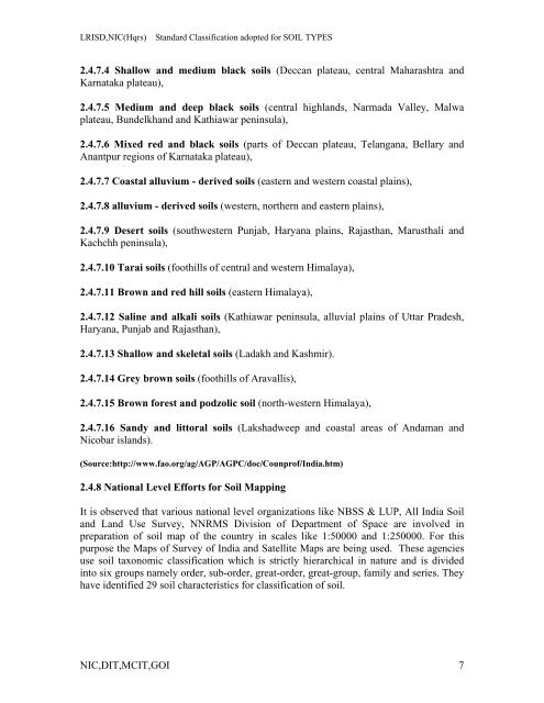
<strong>2.4</strong>.7.4 Shallow and medium black soils (Deccan plateau, central Maharashtra and<br />
Karnataka plateau),<br />
<strong>2.4</strong>.7.5 Medium and deep black soils (central highlands, Narmada Valley, Malwa<br />
plateau, Bundelkhand and Kathiawar peninsula),<br />
<strong>2.4</strong>.7.6 Mixed red and black soils (parts of Deccan plateau, Telangana, Bellary and<br />
Anantpur regions of Karnataka plateau),<br />
<strong>2.4</strong>.7.7 Coastal alluvium - derived soils (eastern and western coastal plains),<br />
<strong>2.4</strong>.7.8 alluvium - derived soils (western, northern and eastern plains),<br />
<strong>2.4</strong>.7.9 Desert soils (southwestern Punjab, Haryana plains, Rajasthan, Marusthali and<br />
Kachchh peninsula),<br />
<strong>2.4</strong>.7.10 Tarai soils (foothills of central and western Himalaya),<br />
<strong>2.4</strong>.7.11 Brown and red hill soils (eastern Himalaya),<br />
<strong>2.4</strong>.7.12 Saline and alkali soils (Kathiawar peninsula, alluvial plains of Uttar Pradesh,<br />
Haryana, Punjab and Rajasthan),<br />
<strong>2.4</strong>.7.13 Shallow and skeletal soils (Ladakh and Kashmir).<br />
<strong>2.4</strong>.7.14 Grey brown soils (foothills of Aravallis),<br />
<strong>2.4</strong>.7.15 Brown <strong>for</strong>est and podzolic soil (north-western Himalaya),<br />
<strong>2.4</strong>.7.16 Sandy and littoral soils (Lakshadweep and coastal areas of Andaman and<br />
Nicobar islands).<br />
(Source:http://www.fao.org/ag/AGP/AGPC/doc/Counprof/India.htm)<br />
<strong>2.4</strong>.8 National Level Ef<strong>for</strong>ts <strong>for</strong> Soil Mapping<br />
It is observed that various national level organizations like NBSS & LUP, All India Soil<br />
and Land Use Survey, NNRMS Division of Department of Space are involved in<br />
preparation of soil map of the country in scales like 1:50000 and 1:250000. For this<br />
purpose the Maps of Survey of India and Satellite Maps are being used. These agencies<br />
use soil taxonomic classification which is strictly hierarchical in nature and is divided<br />
into six groups namely order, sub-order, great-order, great-group, family and series. They<br />
have identified 29 soil characteristics <strong>for</strong> classification of soil.<br />
NIC,DIT,MCIT,GOI 7


