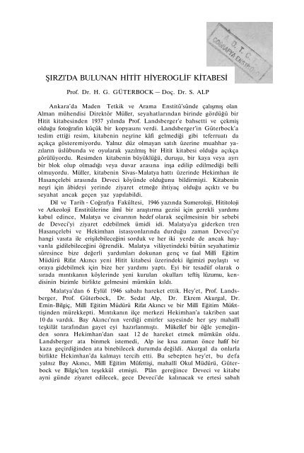
ŞIRZl'DA BULUNAN HİTİT HİYEROGLİF KİTABESİ
ŞIRZl'DA BULUNAN HİTİT HİYEROGLİF KİTABESİ
ŞIRZl'DA BULUNAN HİTİT HİYEROGLİF KİTABESİ

You also want an ePaper? Increase the reach of your titles
YUMPU automatically turns print PDFs into web optimized ePapers that Google loves.
<strong>ŞIRZl'DA</strong> <strong>BULUNAN</strong> <strong>HİTİT</strong> <strong>HİYEROGLİF</strong> <strong>KİTABESİ</strong><br />
Prof. Dr. H. G. GÜTERBOCK — Doç. Dr. S. ALP<br />
Ankara'da Maden Tetkik ve Arama Enstitü'sünde çalışmış olan<br />
Alman mühendisi Direktör Müller, seyahatlarından birinde gördüğü bir<br />
Hitit kitabesinden 1937 yılında Prof. Landsberger'e bahsetti ve çekmiş<br />
olduğu fotoğrafın küçük bir kopyasını verdi. Landsberger'in Güterbock'a<br />
teslim ettiği resim, kitabenin neşrine kâfi gelmediği gibi teferruatı da<br />
açıkça gösteremiyordu. Yalnız düz olmayan satıh üzerine muahhar yazıların<br />
üslûbunda ve oyularak yazılmış bir Hitit kitabesi olduğu açıkça<br />
görülüyordu. Resimden kitabenin büyüklüğü, duruşu, bir kaya veya ayrı<br />
bir blok olup olmadığı veya duvar arasına inşa edilip edilmediği belli<br />
olmuyordu. Müller, kitabenin Sivas-Malatya hattı üzerinde Hekimhan ile<br />
Hasançelebi arasında Deveci köyünde olduğunu bildirmişti. Kitabenin<br />
neşri için âbideyi yerinde ziyaret etmeğe ihtiyaç olduğu açıktı ve bu<br />
seyahat ancak geçen yaz yapılabildi.<br />
Dil ve Tarih - Coğrafya Fakültesi, 1946 yazında Sumeroloji, Hititoloji<br />
ve Arkeoloji Enstitülerine ilmî bir araştırma gezisi için gerekli yardımı<br />
kabul edince, Malatya ve civarının hedef olarak seçilmesinin bir sebebi<br />
de Deveci'yi ziyaret edebilmek ümidi idi. Malatya'ya giderken tren<br />
Hasançelebi ve Hekimhan istasyonlarında durduğu zaman Deveci'ye<br />
hangi vasıta ile erişilebileceğini sorduk ve her iki yerde de ancak hayvanla<br />
gidilebileceğini öğrendik. Malatya vilâyetindeki bütün seyahatimiz<br />
süresince bize değerli yardımları dokunan genç ve faal Millî Eğitim<br />
Müdürü Rifat Akıncı yeni Hitit kitabesi üzerindeki ilgimizi paylaştı ve<br />
oraya gidebilmek için bize her yardımı yaptı. Eyi bir tesadüf olarak o<br />
sırada mıntıkanın köylerinde yeni kurulan okulları teftiş lüzumu, kendisinin<br />
bizimle birlikte gelmesini mümkün kıldı.<br />
Malatya'dan 6 Eylül 1946 sabahı hareket ettik. Hey'et, Prof. Landsberger,<br />
Prof. Güterbock, Dr. Sedat Alp, Dr. Ekrem Akurgal, Dr.<br />
Emin-Bilgiç, Millî Eğitim Müdürü Rifat Akıncı ve bir Millî Eğitim Müfettişinden<br />
mürekkepti. Mıntıkanın ilçe merkezi Hekimhan'a takriben saat<br />
10 da vardık. Bay Akıncı'nın verdiği emirler sayesinde her şey mahallî<br />
teşkilât tarafından gayet eyi hazırlanmıştı. Mükellef bir öğle yemeğinden<br />
sonra Hekimhan'dan saat 12 de hareket etmek mümkün oldu.<br />
Landsberger ata binmek istemedi, Alp ise kısa zaman önce hafif bir<br />
kaza geçirdiğinden ata binebilecek durumda değildi. Akurgal da onlarla<br />
birlikte Hekimhan'da kalmayı tercih etti. Bu sebepten hey'et, bu defa<br />
yalnız Bay Akıncı, Millî Eğitim Müfettişi, mahallî Okul Müdürü, Güterbock<br />
ve Bilgiç'ten teşekkül etmişti. Plân gereğince Deveci ve kitabe<br />
ayni günde ziyaret edilecek, gece Deveci'de kalınacak ve ertesi sabah
148<br />
H. G. GÜTERBOCK-S. ALP<br />
Hekimhan'a dönülecekti. Atla iki saatta Deveci'ye gidildi. Fakat orada<br />
kimsenin herhangi bir "yazılı taştan,, haberi yoktu. Köylüler, maden<br />
mühendislerinin gelişlerini iyi hatırlıyorlar, onların gittikleri ve resim<br />
çektikleri her yeri gösterebileceklerini, fakat bir kitabeden malûmatları<br />
olmadığını söylüyorlardı. Bay Müller'in çektiği resim kendilerine<br />
gösterilince, tanımadılar. Durumun cesaret kırıcı olmasına rağmen hey'et,<br />
mühendislerin gördükleri ve resim çektikleri yerleri, Bay Müller'in<br />
kitabenin resmini aldığı yer onlar arasında olur ümidiyle, ziyaret etmeğe<br />
karar verdi. Köylüler, hey'eti kuzey-doğu istikametinde, Deveci'ye 1<br />
saat mesafede, fazla demir ihtiva ettiği anlaşılan ve eski ocak faaliyetinin<br />
izlerini gösteren Maden Dağı'na şevkettiler. Fakat kitabeye benzer<br />
bir şeyin bulunması hakkında beslenilen ümit artık kırılmıştı. Kayanın<br />
sathı bir kitabe için tamamen gayri müsaitti ve yassı parçalar halinde<br />
dağılıyordu. Bu gezinin yegâne mükâfatı, tepeyi kaplayan parçalar arasında<br />
bulunan Bizans devrine ait çanak çömlek kırıkları idi. Hayal<br />
sukutunun büyük olduğu bir sırada akşam karanlığında Landsberger'den<br />
getirilen bir haberde kendisinin ve Alp'in bir Hitit kitabesi buldukları,<br />
geceyi Şırzı'da geçirecekleri ve ertesi sabah Şırzı yakınında<br />
bir yerde Deveci'ye giden arkadaşları bekliyecekleri bildiriliyordu.<br />
Haberciye Bay Müller'in çektiği fotoğraf gösterilince, Landsberger ve<br />
Alp ile birlikte gördüğü kitabeyi derhal tanıdı.<br />
Mühendisler 1937 yılında Şırzı'yı ve Deveci'yi ziyaret etmişlerdi 1.<br />
Deveci, Maden Dağında çalıştıkları yer olduğundan Bay Müller'in hafızasında<br />
Şırzı yerine Deveci kalmış olacaktır. Böylece Şırzı kitabesi<br />
Landsberger ile Alp tarafından yeniden keşf edilmiş oldu. Onlar, kitabeyi<br />
gördükleri zaman, Müller'in gördüğü kitabenin ayni olduğunu bilemediler;<br />
çünkü fotoğraf, hey'etin Deveci'de bulunan azası yanında idi.<br />
Kitabe nasıl bulundu ?<br />
Anadolunun bütün küçük kasabalarında olduğu gibi Hekimhan'da<br />
da halk mütecessistir. Gelen mütehassısların kimler olduğunu ve ne<br />
maksatla geldiklerini öğrenmek ve onlara elden geldiği kadar yardım<br />
etmek ister.<br />
Hekimhan'da kalan Landsberger, Alp ve Akurgal halkın yardımından<br />
faydalanarak muhitteki antikiteler hakkında malûmat toplamayı Ve<br />
mümkünse yeni hedefler tespitini düşündüler. Bu maksatla çarşıya<br />
çıktıkları zaman halk ve civardan alış-veriş için gelen köylüler derhal<br />
etraflarını aldılar. Konuşma esnasında birbirinden uzak mesafelerde<br />
bulunan muhtelif noktalar hakkında o kadar çok malûmat veriliyordu<br />
ki, bunlar arasında bir seçim yapmak ve eldeki zamanın azlığını göz<br />
önünde tutarak en ehemmiyetli istikamette harekete geçmek cidden<br />
güçtü. Bilgimize göre Hekimhan mıntıkası şimdiye kadar diğer sey-<br />
1 Krş. V. Kovenko, Hasan Çelebi Mıntıkası Demir yatakları, Maden Tetkik ve<br />
Arama Enstitüsü Mecmuası, sene 5, 1940, sayı 1/18, s. 75 v. d.
ŞIRZI'DA <strong>BULUNAN</strong> <strong>HİTİT</strong> <strong>HİYEROGLİF</strong> <strong>KİTABESİ</strong> 149<br />
yahlar tarafından incelenmemiş olduğundan burasının bazı kıymetli<br />
buluntulara sahne olabileceği evvelden tahmin edilebilirdi. Mektep<br />
binasında ve çarşıda hey'etin yanına gelen kimseler şu noktalar hakkında<br />
malûmat verdiler: I- Girmana, Alahisar Tepesi; II- İbocuk (üç<br />
tepe, mabetler ve heykel) 2 ; III- Kızılhisar (Hekimhan'a 3,5 saatlik mesafede)<br />
3 ; IV- Hasan Çelebi istasyonu (Maltepe); V- Cüzüngüt asarı<br />
(Hekimhan istasyonuna 1 saatlik mesafede); VI- Saz köyü (altın sikkeler,<br />
Deveci civarında); VII- Salacak 4 (büyük höyük, Hekimhan'ın doğusunda<br />
1,5 saatlik mesafede) ; VIII- Mal mağarası (Hekimhan'a 1 saatlik<br />
mesafede); IX- Şırzı (kitabe); X- Akpınar (kitabe). Bu arada Şırzı<br />
köyü muhtarı Vahap Durmuş'un ve ayni köy halkından Mustafa Ulaş'ın,<br />
sonuncusunun tarlasında bulunan kitabe hakkında söyledikleri en<br />
çok dikkati çekti. Kitabenin tasvirinden bir Hitit hiyeroglif kitabesi<br />
bahis mevzuu olduğunu istihrac etmek kolay değildi. Hele bunun Deveci'de<br />
olduğu bildirilen kitabe olabileceği tabii akla gelmemişti. Verilen<br />
malûmat daha ziyade bir Yunan kitabesi lehinde idi. Sorulan muhtelif<br />
sorulardan nihayet bir Hitit hiyeroglif kitabesi olabileceği anlaşılınca,<br />
Landsberger ve Alp, kitabenin bulunduğu yere gitmeğe karar verdiler.<br />
Akurgal, daha bazı malûmat toplamak üzere Hekimhan'da kaldı ve<br />
ertesi gün kendisine gönderilen haber üzerine Şırzı'da hey'ete iltihak etti.<br />
Hey'et, muhtar Vahap Durmuş, Mustafa Ulaş ve tüccardan Rüştü<br />
Önder'in refakatinde Hekimhan'dan saat 14 te yola çıktı. Şırzı için, Kuruçay<br />
vadisinde demiryoluna muvazi giden ve son yıllarda pek kullanılmayan<br />
Malatya - Sivas şosesi kısmen yol olarak kullanılıyor. Köye<br />
tahminen 4 kilometre kala şoseden kuzey doğu istikametinde yamaca<br />
tırmanan patika yoluna sapmak mecburiyeti vardır.<br />
Üç buçuk saat kadar süren yolu kısmen yaya olarak, kısmen<br />
eşek üzerinde kat'ettikten sonra meyilli bir düzlükte bulunan ve dağdan<br />
kopmuş bir kaya bloku üzerine hakkedilmiş olan kitabenin yanına<br />
varınca bir Hitit hiyeroglif kitabesi ile karşılaşıldı. Bunun üzerine<br />
Landsberger ile Alp derhal kitabeyi kopya etmeğe başladılar. Akşam<br />
olduğu zaman köyde misafir edildikleri yeni okul binasında geceyi<br />
geçirmek üzere Şırzı'ya gittiler.<br />
Şırzı köyü 1: 800 000 mikyaslı Türkiye haritasının Sivas paftasında<br />
H 29 murabbaında kuzeyde Hasançelebi ile güneyde Hekimhan<br />
arasında gösterilmiştir. Sivas - Malatya şosesinin ve demiryolunun<br />
2 I ve II'nin bir günde ziyaret edilebilecekleri söylenilmiştir. İlk yer, Hekimhan'ın<br />
takriben 18-20 km. güney doğusunda ve Kuruçay vadisinin güney batısındaki etekte,<br />
Türkiye haritasında (1 : 800 000) «Girmane» diye gösterilmiştir. Kiepert'in haritasında<br />
ise «Kirmane» diye iki yer adı vardır ; bunlardan biri daha batıdaki dağlardadır. İkinci<br />
yer, yalnız Kiepert'in haritasında Kirmanâ'nın batısında işaret edilmiştir (orada:<br />
Ibudjuk).<br />
3 Türkiye haritasında Hekimhan'ın takriben 16 km. batısında bir köy ve bir dağ<br />
adı olarak gösterilmiştir.<br />
4 Türkiye haritasında Hekimhan'ın kuzey doğusunda : Salıcık. Kiepert haritasın<br />
da «Devedji» ve «Saldjyk»'ın yerleri yanlışlıkla değişmişe benziyor.
150 H. G. GÜTERBOCK - S. ALP<br />
geçtiği Kuruçay vadisinin hemen üstündedir. Deveci, Şırzı'nın doğusundaki<br />
dağlık arazidedir ve haritada işaret edilmiştir 5 .<br />
Şırzı'ya takriben yarım saat mesafede "Ören,, denilen büyük bir<br />
şehir harabesi bize gösterildi. Harabede taş duvarların bakiyeleri<br />
kolayca görülmektedir. Toplanılan çanak çömlek parçaları Romalılar<br />
devrine ait olduğunu gösteriyor. Bu yerin evvelce malûm olup olmadığını<br />
ve Kiepert'in haritasındaki "ad Praetorium,, ifadesi ile ilgisinin<br />
derecesini bilemiyoruz.<br />
Hiyeroglif kitabesi, köyün tahminen 2 kilometre güney - batısında<br />
ve "Ören,, den ise bir saatlik mesafededir, "Ören,,, Romalılar devrine<br />
ait olduğuna ve zaten aradaki mesafenin uzaklığına göre, kitabenin<br />
"Ören,, ile münasebeti yoktur. Kitabe, dağ silsilesinin batı yamacında,<br />
vadiye manzarayı kapayan küçük ve tabiî bir sed üzerinde bulunuyor.<br />
Bununla beraber toptan konuşulursa, Şırzı'nın ve kitabenin bulunduğu<br />
dağlar Kuruçay vadisine hâkimdirler. Yalnız kitabenin bulunduğu<br />
noktadan vadi görülememektedir. Kitabe, meyilli toprakta müstakil<br />
olarak duran 2,5 m. eninde ve 1,5 m. boyunda büyük bir kaya bloku<br />
üzerine hakkedilmiştir. Yamacın üstünde görünen kayalardan kopmuş<br />
ve yuvarlanmış olması muhtemeldir. Akurgal, Bilgiç ve Bay Akıncı bu<br />
kayalara atla gittilerse de orada ilgi çeker bir şey bulamadılar. Kitabeyi<br />
ihtiva eden kayanın aşağıya yuvarlanmadan evvel mi, yoksa şimdi<br />
bulunduğu yerde mi hakkedildiği sorusu orada hemen ortaya çıktı ve<br />
münakaşa edildi. Kitabenin kayanın meyilli duruşuna uyması, ikinci<br />
ihtimalin lehindedir. Satırlar sağdan sola aşağıya doğru meyilli gittikleri<br />
halde işaretler tamamen amudî olarak sıralanmıştır. Bu tanzime göre<br />
kitabe hakkedildiği zaman kaya, şimdiki yerinde durmuş olsa gerektir.<br />
Kaya civarında hiç bir bina veya tapınak izine rastlanmadığından<br />
kayanın belki Hititler devrinde aşağıya düştüğü ve kitabenin bu hadiseyi<br />
veya herhangi bir hadiseyi canlandırmak ve hatırlatmak maksadıyle<br />
yazıldığı akla gelebilir.<br />
İşaretler kayanın sathına oyulmuştur ve son devirde umumiyetle<br />
kullanılan uslûptadır. İlk üç satırdan her birinin ortalama yüksekliği<br />
20 sm'dir, dördüncü satır ise daha geniş bir sathı kaplıyor ve satırın<br />
altına çizgi çizilmemiştir. Satıh, pek düzeltilmemiş ve bir dereceye kadar<br />
olduğu gibi pürüzlü bırakılmıştır. Kitabenin büyük bir kısmı ve daha<br />
ziyade sol tarafı, işaretleri örten ve uzaklaştıramadığımız açık renkli<br />
yosunla kaplıdır. Birinci satır, bir kaç işaret müstesna, maalesef tamamen<br />
haraptır.<br />
Bir gün önce Landsberger ile Alp'in kopya etttikleri parçayı, Güterbock<br />
ile Alp, 7 Eylül 1946 günü orijinal ile karşılaştırdıktan sonra<br />
kitabenin kalan kısmını kopya ettiler. Güterbock'un çektiği fotoğraflar<br />
5 Şırzı, Kiepert'in haritasına alınmamıştır. O civarda bir dağ adı olarak «Bally<br />
Kaja» (Ballı Kaya) gösterilmiştir. Deveci için bk. not 4.
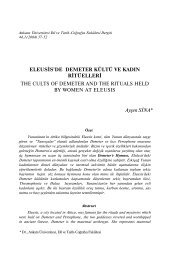
Güterbock — Alp<br />
Şırzı kitabesinin sağ kısmı.<br />
Right part of the Şırzı inscription.<br />
Şırzı kitabesi
Şırzı Kitabesi<br />
Güterbock — Alp
ŞIRZI'DA <strong>BULUNAN</strong> <strong>HİTİT</strong> <strong>HİYEROGLİF</strong> <strong>KİTABESİ</strong> 151<br />
iyi çıktı ve işe yarar bir şekilde büyültülebildi. Burada neşredilen metin,<br />
fotoğraf üzerine çizilmiş ve fotoğrafın rengi yedirilmek usulü ile<br />
elde edilmiştir. Makalenin müellifleri hem el kopyasına hem de muhtelif<br />
resimlerdeki izlere müracaat ederek her bir işaret üzerinde-durmuşlar<br />
ve münakaşa etmişlerdir. Böyle olduğu halde bazı sorular kalmakta<br />
ve çözümleri orijinalin yeniden muayenesine bağlı bulunmaktadır.<br />
Fakat bu gibi sorular çok değildir ve kopyamızın ilk defa olarak<br />
yayım için oldukça şayanı itimat olduğunu sanıyoruz. Kitabenin üst ve<br />
sol taraflarından daha fazla bir şey kazanılabileceği şüphelidir.<br />
Metnin tercümesini vermekten çekiniyoruz. Diğer metinlerden tanınan<br />
ve muhtelif araştırıcılar tarafından şu veya bu şekilde tercüme edilen<br />
sözlerle bazı işaret gruplarını tanıyabiliyoruz. Fakat Hitit hiyerogliflerini<br />
çözümlemenin şimdiki durumunda metnin tamamını tercüme etmek şöyle<br />
dursun, transkripsiyonu bile vermeye cür'et edemiyoruz. Metnin okunabilen<br />
kısmında ne şahıs ne de coğrafya adı geçmediği anlaşılıyor.<br />
Eğer kitabede herhangi bir şehrin hükümdarının adı mevcut ise, bunun<br />
metnin ümitsiz bir durumda olan başında yazılmış olması beklenir.<br />
"Geyik boynuzu,, işareti (Meriggi'nin listesinde No. 120) ile yazılan ve<br />
umumiyetle "Ruta„ (veya benzeri) diye okunan tanrı adının metnin<br />
muhtelif yerlerinde geçtiği açıkça görülüyor ve metinde adı geçen<br />
yegâne tanrı olduğu anlaşılıyor.<br />
Metnimize en yakın hiyeroglif kitabeleri, Tohmaçayı vadisinde<br />
Kötükale, Ispekçür, Darende ve Gürün'dedir. Şırzı, coğrafya bakımından<br />
bu mıntıkadan ayrıdır. Metinde hiç bir coğrafya adı bulunmadığından<br />
bu grupla ilgisi açıkça tespit edilemiyor. Diğer taraftan Malatya'da<br />
muhtelif hiyeroglif kitabeleri bulunan Arslantepe'ye gelince, bu<br />
şehrin adı Gürün'e kadar bütün kitabelerde geçtiğine göre Tohmaçayı<br />
vadisi Malatya mıntıkasına aitti. Kuruçay vadisi de Malatya ovasına<br />
doğru açıldığına göre Şırzı'nın da Malatya kırallığına bağlı olması<br />
muhtemeldir.<br />
Hekimhan'dan hareket ederek Çetinkaya istasyonuna geldikten<br />
sonra, orada Şırzı köyü halkından Ahmet Şahin adında bir kimseye<br />
rast geldik. Bu yurddaşın ifadesine göre Şırzı ve Deveci yanında Başak<br />
denilen yerde Şırzı'daki kitabeye benzer bir kitabe daha vardır.<br />
Hekimhana dönerek bu kitabeyi ziyaret etmek ve bir hiyeroglif kitabesi<br />
olduğunu teyid etmek maalesef mümkün olmamıştır.
THE HITTITE HIEROGLYPHIC INSCRIPTION OF ŞIRZI.<br />
BY H. G. GÜTERBOCK and S. ALP<br />
In 1937, Director Müller, a German engineer who worked with the<br />
Maden Tetkik ve Arama Enstitüsü (Institute for the Study and Investigation<br />
of Mines) at Ankara, mentioned a Hittite inscription he had seen<br />
on one of his journeys. He had taken a small photograph of the inscription<br />
of which he kiadly gave a copy to Prof. Landsberger, who turned<br />
it over to Güterbock. The picture was too small to show the<br />
detail clearly and was not suitable for publication; but it made it sufficiently<br />
clear that there was a new Hittite inscription in late incised<br />
writing on an uneven surface of stone. The size and position of the<br />
monument, whether it was a rock, an isolated block or a stone built<br />
into a wall, could not be made out from the picture. As îocation of<br />
the inscription Mr. Müller mentioned a village called Deveci, not far<br />
from the railway stations of Hekimhan and Hasançelebi on the Sivas-<br />
Malatya line. it was clear that only by visiting the place would it be<br />
possible to make a copy of the inscription, but this visit could not be<br />
made until last summer.<br />
When the Faculty of Letters of the University of Ankara kindly granted<br />
the funds for a scientific excursion to the İnstitutes of Sumerology, Hittitology<br />
and Archaeology in the summer of 1946, one of the reasons for<br />
choosing the environs of Malatya as our goal was our hope to be<br />
able to visit Deveci. When the train stopped at the stations of Hasançelebi<br />
and Hekimhan on our way to Malatya, we asked how we<br />
could reach that village. At both places. we were told that it could be<br />
done only on horseback. At Malatya, the young and very active Director<br />
of Public Instructi'on, Mr. Rıfat Akıncı, to whom we are much indebted<br />
for valuable help during the whole of our journey, immediately<br />
shared our interest in the new Hittite inscription and did everything to<br />
help us to reach the place. Moreover, as it happe'ned that he had to<br />
inspect the recently organized primary schools in the villages of that<br />
region, he made it possible to gq with us.<br />
Thus, we left Malatya by train on the morning of September<br />
6th, 1946. The members of the expedition were Professors Landsberger<br />
and Güterbock, Dr. Sedat Alp, Dr. Ekrem Akurgal, Dr. Emin Bilgiç,<br />
Director Akıncı and an inspector in the department of Public Instruction<br />
at Malatya. We arrived at Hekimhan, center of a district (ilçe or<br />
kaza), at about 10 a. m. Thanks to the orders given by Mr. Akıncı,<br />
everything had been very well prepared by the local authorities, so<br />
that, after a copious lunch, we were able to leave Hekimhan at 12
154 H. G. GÜTERBOCK and S. ALP<br />
o'clock. Landsberger did not want to ride a horse, Alp who just before<br />
had had a slight accident was not able to do so either, and<br />
Akurgal chose to stay with them at Hekimhan. Therefore, the expedition,<br />
this time, consisted of Mr. Akıncı, the Inspector, the local School<br />
Director, Güterbock and Bilgiç, it wa? lanned that these should visit<br />
Deveci and the inscription on the same day, spend the night at Deveci,<br />
ând come back to Hekimhan the next morning. Deveci was<br />
reached after two hours' ride, but nobody there had ever heard of<br />
an „inscribed stone". Ali the villagers very well remembered the visit<br />
of the mining engineers, they said they were able to show ali the<br />
places which the engineers had visited and where they had taken<br />
pictures, but they knew nothing of an inscription and could not identify<br />
Mr. Müllers photograph when it was shown to them. in spite of<br />
these discouraging prospects the expedition decided to visit the places<br />
the engineers had seen and photographed, hoping the place where<br />
Mr. Müller had taken the picture of the inscription would be among<br />
hem. The villagers led the way to the so-called Maden Dağı („Mine<br />
Mountain"), about one hour north-east of Deveci, a mountain apparently<br />
containing much iron, with traces of old mining activities. But the<br />
party was disappointed in its hope of finding anything there like an<br />
inscription; moreover, the surface of the rock was completely unfit for<br />
an inscription as it crumbled off in flat splinters. The only reward of<br />
this frip were some byzantine potsherds collected on the hill, among<br />
the splinters which covered its whole surface. The disappointment<br />
was great until, late in the evening, a man brought a message from<br />
Landsberger saying that he and Alp had found a Hittite inscription,<br />
that they were going to spend the night at Şırzı, and that they would<br />
wait at a place near that village for their comrades next morning.<br />
When the messenger was shown Mr. Müller's photograph, he at önce<br />
recognized the inscription seen by him with Landsberger and Alp.<br />
The engineers had, in 1937, visited both Şırzı and Deveci, 1 and as<br />
Deveci was the place where they worked on the »Maden Dağı",<br />
apparently its name had stayed in Mr. Müller's memory rather than<br />
that of Şırzı. The Şırzı inscription, therefore, had to be re-discovered<br />
by Landsberger and Alp who, when they saw it, did not know that<br />
it was the same as had been seen by Mr, Müller, his photograph<br />
being with the other members of the staff at Deveci. How had they<br />
found it?<br />
As in most small Anatolian places the people of Hekimhan were<br />
eager to know who the newly arrived'specialists were, and to help<br />
them as far as possible. Landsberger, Alp and Akurgal who stayed at<br />
1 Cp. V. Kovenko, Hasan Çelebi Mıntıkası Demir Yatakları = Les gîtes de fer<br />
de la region de Hasançelebi, in : Maden Tetkik ve Arama Enstitüsü Mecmuası, sene<br />
5, 1940, No. 1/18, p. 75-93.
THE HITTİTE HIEROGLYPHIC INSCRIPTION OF ŞIRZI 155<br />
Hekimhan vvanted to obtain some indications about the antiquities of<br />
the region and, if possible, with the help of the people, to determine<br />
new goals for scientific research. When they came to the<br />
market they were immediately surrounded by the inhabitants<br />
of the place and by the villagers who had come there for trade.<br />
While talking to them they heard of so many different places at such<br />
seattered intervals, that it was really difficult to choose the most<br />
important, especially in view of the short time available. Since the environs<br />
of Hekimhan, as far as we can see, have not yet been thoroughly<br />
investigated, one could expect a certain amount of new information.<br />
From the information given to the expedition by different persons<br />
during its stay'at the school house and on the market, the following<br />
items were noted:<br />
1) Girmana, Akhisar tepesi („hill" or „mound").<br />
2) Ibocuk (three „hills" or „mounds", „temples" and a »statue (?)");<br />
it vvas said that points 1 and 2 together could be visited in one day,<br />
which gives an idea of their approximate distance from Hekimhan 2 .<br />
3) Kızılhisar (3 1/2 hours on foot from Hekimhan 3 )<br />
4) A mound called Maltepe („Treasure Mound") near the railvvay<br />
station of Hasançeîebi.<br />
5) The ancient remains (asar) of Cüzüngüt ( 1 hour from the station<br />
of Hekimhan).<br />
6) Sazköyü near Deveci .(gold coins reported).<br />
7) Salacak (big mound; 1 1/2 hours from Hekimhan 4 ).<br />
8) A cave called Mal Mağarası (1 hour from Hekimhan).<br />
9) Şırzı (inscription).<br />
10) Akpınar (inscription).<br />
Among these, the information given by the muhtar (village mayor)<br />
of Şırzı, Vahap Dursun, and a man called Mustafa Ulaş from the same<br />
village, in whose field the inscription was said to be situated, seemedthe<br />
most interesting. it was not easy, though, to make out vvhether the inscription<br />
mentioned was Hittite, and of course there was no reaşon to<br />
think that it was the one reported from Deveci. The description given<br />
by the villagers first seemed rather to point to a Greek inscription,<br />
but on further questions it seemed possible that a Hittite inscription<br />
2<br />
The first plaee is marked Girmane on the Turkish Map (1: 800000), on the<br />
S. W. slope of the Kuruçay valley, about 18-20 km S. E. of Hekimhan (Kiepert's<br />
map has twö «Kirmane», one farther down in the valley, the other farther W.<br />
in the mountains). The second place is indicated only on Kiepert's map, W. of the<br />
lower Kirmana (spelled Ibudjuk).<br />
3<br />
Marked on the Turkish map<br />
16 km W. of Hehimhan.<br />
as the name of a village and a mountain, about<br />
4<br />
Salıcık, N. E. of Hekimhan, on the Turkish map. On Kiepert's map, the posi-<br />
tions of «Devedji» and «Saldjik» seem to have been changed by mistake.
156 H. G. GÜTERBOCK and S. ALP<br />
might be meant; thereupon Landsberger and Alp decided to go there.<br />
Akurgal stayed in Hekimhan to collect more information and went to<br />
Şırzı only the next day on receipt of a message.,<br />
Landsberger and Alp left Hekimhan at 2 p. m. with the mayor<br />
Vahap Durmuş, Mustafa Ulaş and a merchant from Hekimhan called<br />
Rüştü Önder. They followed the road running parallel to the railroad<br />
in the Kuruçay valley to the North. About 4 km before reaching Şırzı<br />
they had to leave the road and had to take a path climbing the<br />
mountain slope to to the Northeast. Af ter a march of 3 1/2 hours,<br />
partly on foot, partly on a donkey, they reached a block lying on<br />
the slope. As they approached, they saw that it bore an inscription<br />
in Hittite hieroglyphs. Landsberger and Alp immediately started copying<br />
it. in the evening they went to the vilkge of Şırzı whe/e they<br />
passed the night as guests in the new school - house.<br />
The village of Şırzı is mârked on the 1: 800 000 map of Turkey,<br />
section of Sivas, square H 29, betvveen Hasan Çelebi in the North<br />
and Hekimhan in the South, it is just above the Kuruçay valley in<br />
which both the road and the railvvay from Sivas to Malatya run. Deveci<br />
is situatad east of Şırzı, in the mountains, and also marked on<br />
the Türkish map 5 .<br />
About half-an-hour's walk north-east of Şırzı we were shown some<br />
ruins, a large „ören" with many stone walls easily traceable in the<br />
ground. The potsherds collected there proved to belong to the Roman<br />
period. We are not able to say vvhether this place is already known<br />
and whether the ancient name „ad Praetorium" which appears on Kiepert's<br />
map in the vicinity has anything to do with it.<br />
The inscription lies about 2 km south - west of the village and<br />
about one hour from the ören; this distance, taken with the difference<br />
of periods, shöws that there can be no connection betvveen the ruins<br />
and the inscription. The inscription is situated on the west slope of<br />
the mountain fange, above a small natural terrace which bars the<br />
view of the valley. Although, roughly speaking, the mountains on<br />
which the village of Şırzı as well as the inscription are situated, dominate<br />
the Kuruçay valley, the individual spot of the inscription does<br />
not really overlook the valley. The inscription itself is incised on a<br />
huge block, about 1.5 m high and 2.5 m wide, which lies loose on<br />
the sloping ground. Apparently it has rolled down from a group of<br />
rocks visible at the top of the slope. Akurgal, Bilgiç and Mr. Akıncı<br />
rode up to these rocks but could not find anything of interest there.<br />
The question arose, and was discussed on the spot, vvhether the<br />
block had been inscribed when it was stili up there and had rolled<br />
5 Şırası does not appear on Kiepert's map which gives «Bally Kaja» (Ballı Kaya)<br />
as the name of a mountain in the vicinity. For Deveci see n. 4.
THE HITTITE HIEROGLYPHIC INSCRIPTION OF ŞIRZI 157<br />
down in historical times, or whether it had been inscribed in its<br />
present position. The fact that the inscription follows the oblique<br />
situation of the block is in favour of the second alternative. The vertical<br />
rows of signs are really perpendicular now, although the Iines<br />
are slanting downward from right to left; this arrangement suggests<br />
that the block was in its present position when the inscription was<br />
made. Since no traces of buildings or worship are visible near the<br />
block, one might even imagine that the block rolled down in Hittite<br />
times and that the inscription was meant to commemorate this very<br />
incident.<br />
The signs are incised and show the current style of the late period.<br />
The average height of the first three lines is 20 cm, whereas the fourth<br />
line covers a broader part of the, surface and its bottom is not marked<br />
by a stroke. The surface has not been smoothed artificially but left<br />
more or less uneven as it was. it is covered by spots of light - coloured<br />
lichen vvhich we could not remove and which obliterate some parts<br />
of the inscription, especially toward its left end. The first line, unfortunately,<br />
is almost illegible.<br />
When Landsberger and Alp arrived there in the afternoon of<br />
September 6 th, they started copying the inscription immediately. The<br />
next day, Güterbock and Alp collated the part of the copy made the<br />
first day and copied the rest of the inscription. Güterbock took some<br />
photographs which came out rather well, allowing considerable enlarging.<br />
The copy published here was drawn at home on a photograph<br />
vvhich aftervvards vvas bleached out, and for each sign both the handcopy<br />
and the traces visible on several photographs were consulted<br />
and discussed by both of the authors of this article. Even so, there<br />
remain some questions, vvhich can be solved only by a new examination<br />
of the original; but these are not many, and we hope that our<br />
copy is fairly reliable for a first edition. There is little hope that<br />
anything can be made out of the top and left part of the inscription.<br />
We abstain from an interpretation of the text. Some groups of<br />
signs we were able to identify with words known from other inscriptions<br />
and interpreted in some way or other by different scholars. But<br />
at the present state of the decipherment of the Hittite hieroglyphs it seems<br />
inadvisable to give a full transliteration, not to speak of a translation.<br />
No personal or geographical names seem to occur in the legible part of<br />
the inscription; if the name of the ruler of a certain city had been<br />
there, it would have been expected at the beginning vvhich is in a<br />
hopeless state. The occurrence of the divine name vvritten vvith the<br />
„antler" sign (nr. 120 of Meriggi's sign list) and read „Ruta" (or the<br />
like) generally, is clear in several places, and this seems to be the<br />
only deity mentioned in the text.
158 H. G. GÜTERBOCK and S. ALP<br />
The nearest group of hieroglyphic inscriptions is that in the Tohmaçayı<br />
valley: Kötükale, Ispekçür, Darende and Gürün. Geographically,<br />
Şırzı is separated from that region, and since no geographical<br />
name can be found in the Şırzı inscription, it is not clear whether it<br />
has anything to do with that group. On the other hand, there is Arslantepe,<br />
the ancient site of Malatya, vvhere several inscriptions have<br />
been found; and the Tohmaçayı valley belonged to the territory of<br />
Malatya as shown by the occurence of the name of that city in ali of<br />
the inscriptions as far up as Gürün. Since the Kuruçay valley, too,<br />
opens towards the Malatya plain, it is very probable that Şırzı belonged<br />
to the kingdom of Malatya as well.<br />
When, on our way home, we stopped at the station of Çetinkaya,<br />
we met a man from Şırzı called Ahmet Şahin. According to him, there<br />
is another inscription, resembling that of Şırzı, at a place called Başak<br />
near Şırzı and Deveci. Unfortunately we hat no time to go back to<br />
Hekimhan and visit that inscription.