Dufton Round Try a Trail[Size: 462.95Kb - National Trails
Dufton Round Try a Trail[Size: 462.95Kb - National Trails
Dufton Round Try a Trail[Size: 462.95Kb - National Trails

You also want an ePaper? Increase the reach of your titles
YUMPU automatically turns print PDFs into web optimized ePapers that Google loves.
<strong>Try</strong> a <strong>Trail</strong> ...<br />
–<br />
<strong>Dufton</strong> round<br />
16 km (10 miles) – challenging circular walk<br />
Walking from <strong>Dufton</strong><br />
1 The walk starts in the car park in<br />
<strong>Dufton</strong>. Leaving the car park, turn<br />
right along the road and then take<br />
the track to the left of <strong>Dufton</strong> Hall<br />
signposted Pennine Way Garrigill.<br />
2 Take the left turn off the track<br />
signposted Pennine Way. Follow the<br />
path until it joins the access track<br />
to Coatsike Farm.<br />
3 Follow the track through the farm<br />
and continue along the tree-lined<br />
lane that eventually descends to<br />
Great Rundale Beck.<br />
4 Cross the stile and stone bridge<br />
across the beck and continue to<br />
follow the track as it becomes a<br />
wide straight enclosed track<br />
bounded by dry stone walls.<br />
5 At the end of the enclosed track<br />
follow the obvious green track up<br />
the hill and turn left onto the path<br />
signposted Pennine Way that leads<br />
to the bridge over Swindale Beck.<br />
6 Cross the footbridge and climb<br />
past the Moor House <strong>National</strong><br />
Nature Reserve sign uphill towards<br />
Knock Old Man. There are<br />
occasional waymarker stones<br />
with carved arrows.<br />
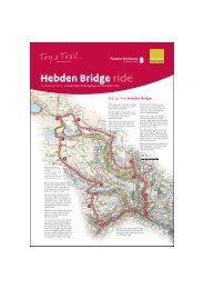
<strong>Dufton</strong> round<br />
11<br />
Start <strong>Dufton</strong> (grid ref NY 690252)<br />
Distance 16km (10 miles)<br />
Height Gain 692 m (2270 ft) with<br />
some steep slopes<br />
Terrain Tracks, natural hillside and fields<br />
Time 5 hours<br />
Refreshment & public toilets<br />
Public toilets and car parking at <strong>Dufton</strong>.<br />
There is also the Stag Inn<br />
How to get there Car or bike<br />
12<br />
7 At the cairn at Knock Old Man<br />
follow the path heading towards<br />
Great Dunn Fell with its golf ball<br />
radar station on top. The path can<br />
be indistinct but is stone flagged in<br />
parts.<br />
8 Turn left leaving the Pennine Way<br />
and descend downhill on the<br />
tarmac access road for the radar<br />
station. Follow the road to the final<br />
right hand corner<br />
before the road crosses<br />
a cattle grid and into a<br />
walled lane.<br />
13<br />
10<br />
3<br />
4<br />
1<br />
2<br />
5<br />
6<br />
Pennine Way<br />
9<br />
NATIONAL TRAIL<br />
9 At this corner a path goes straight<br />
ahead and heads for a large ladder<br />
stile in the fell wall below. Cross the<br />
stile and head across the enclosure<br />
ahead aiming to the left of Knock<br />
Pike. Pass through the small gate<br />
next to another ladder stile and<br />
follow the green track around the<br />
hillside.<br />
10 As the track comes into a field<br />
bear right slightly towards a walled<br />
track leaving the opposite side of<br />
the field. Follow the track to the<br />
minor road at Knock village.<br />
11 Turn left along the road until the<br />
metal public footpath sign on the<br />
left of the road.<br />
12 Cross the stile and via the<br />
footbridge walk to St Cuthbert’s<br />
Church.<br />
13 Follow the church access track<br />
back to the minor road to return to<br />
<strong>Dufton</strong> village.<br />
8<br />
0 1km (0.6mile)<br />
Map reproduced from Ordnance<br />
Survey digital map data<br />
© Crown Copyright 2007<br />
All rights reserved<br />
Licence number 100031673<br />
© Natural England 2007<br />
7
<strong>Try</strong> a <strong>Trail</strong> ...<br />
–<br />
<strong>Dufton</strong> round<br />
16 km (10 miles) – challenging circular walk<br />
A great walk from the floor of the Eden Valley near<br />
Appleby-in-Westmorland to the tops of the North<br />
Pennines. The view from Knock Old Man across the<br />
Vale of Eden to the Lake District fells is worth the climb<br />
<strong>Dufton</strong> is a small village nestling on<br />
the slopes of the northern Pennines<br />
below <strong>Dufton</strong> Pike and Great Dun<br />
Fell. It is 12 miles from Penrith and<br />
3 miles north of Appleby-in-<br />
Westmorland, and both the<br />
Pennine Way and the Pennine<br />
Cycleway pass through the village.<br />
At about 180m above sea level, the<br />
village is aligned roughly east-west<br />
round a rectangular shaped green<br />
bisected diagonally by an avenue<br />
of lime trees. The main feature of<br />
which is the fountain.<br />
This fountain was provided by Mr.<br />
Wallace of the London Lead Mining<br />
Company, which formally worked<br />
the many mines in the area. On it<br />
there is a Latin inscription which<br />
when translated reads:<br />
The Mountain Code<br />
Know how to use a map and<br />
compass<br />
Know the weather signs and local<br />
forecast; plan within your abilities<br />
Know simple first aid and the<br />
symptoms of exposure<br />
Take waterproofs and fleece<br />
Ensure someone knows your plans<br />
Keep alert all day<br />
‘There is a clear pool, whose waters<br />
gleam like silver. It is not tainted by<br />
shepherds, or by their she-goats<br />
grazing on the mountain. Nor is it<br />
muddied by cattle, or by birds or wild<br />
animals, or by a branch fallen from<br />
a tree’<br />
Moor House <strong>National</strong> Nature<br />
Reserve - Upper Teesdale is one of<br />
England’s largest <strong>National</strong> Nature<br />
Reserves. It is particularly well<br />
known for the plants that originally<br />
colonised the high Pennines after<br />
the last Ice Age. You can also see<br />
rare rock formations such as<br />
outcropping sugar limestone and<br />
the Great Whin Sill. The reserve<br />
encompasses an almost complete<br />
range of upland habitats typical of<br />
the North Pennines, from lower<br />
lying hay meadows, rough grazing<br />
and juniper wood to limestone<br />
grassland, blanket bogs and<br />
summit heaths of the high fells.<br />
Route profile<br />
Pennine Way<br />
NATIONAL TRAIL<br />
Great Dun Fell (848 m) in the North<br />
Pennines is home to the Civil<br />
Aviation Authority's air traffic<br />
control radar. The summit radar<br />
domes are visible for a good forty<br />
miles around and many see them<br />
as a visual intrusion, but of course<br />
installations like this have to be<br />
built somewhere.<br />
The abandoned Silverband mine,<br />
worked originally for lead and later<br />
for barite, lie at an altitude of about<br />
701 m on the west side of the ridge<br />
of Great Dun Fell, overlooking the<br />
Vale of Eden. They were worked by<br />
the London Lead Mining Company<br />
during the first half of the<br />
nineteenth century.<br />
www.nationaltrail.co.uk/pennineway