4. description of the environment - Gujarat Pollution Control Board
4. description of the environment - Gujarat Pollution Control Board 4. description of the environment - Gujarat Pollution Control Board
Final Feasibility Report Preparation of Feasibility– cum-Preliminary Design for 4/6 Laning of Jetpur-Somnath section of NH 8D, Package No: NHAI/DBFOII/DPR/02 GEOLOGY ROCKS Recent: Alluvium, Blown Sand & Miliolite Sand. Sub-Recent Pleistocene: Limestones, Sandstones, Shales and Laterite & Bauxite Upper Cretaceous to Palaeocene: Diorites, Basic Intrusives. Deccan Trap: Felsite, Rhyolite & Pitchstone Flows,Basalts Andesite, Trachyte Flows. Holocene Deposits Mesozolcs Sea Porbandar Ranavav Buffer Zone (Upto 15 km from corridor) Taluka boundry MINERALS Mangrol Bauxite Chalk Lead / Zinc / Copper Calcite Ochre Sandstone & Other building stone Gypsum Salt Quartz and silica sand Limestone Agate Fire Clay Nepheline Syenite 5 0 5 Kilometre 10 15 4.3.3 Soil Project Corridor Arabian Sea VOLUME III: ENVIRONMENTAL IMPACT ASSESSMENT Upleta Vanthli Manavadar Padadhari Lodhika Somnath Jetpur Rajkot Wankaner Kotda Sangani Gondal Jam Kandorna chorwad Figure 4-2: Geology of the Project Area The geographical formation of Saurashtra region is of volcanic origin, hence the soils of Rajkot district are derived from trap rock. The land of the project region that falls in Rajkot district is mainly divided into two types: Salty land is mainly the type of land in Morbi and Maliya and black, loamy soil is mainly present in Jetpur and Dhoraji talukas. The soil of the project region that falls in Jetpur taluka is red soil. In Junagadh district, the soils are formed partly from sedimentary rocks and partly from igneous rocks. They are calcareous in nature, rich in potassium content but deficient in nitrogen and humus. The main types of soils in the district are black, medium black, alluvial soil in the lowlying area, calcareous and brackish. The black soil is found in parts of Vanthali, Manavdar and Keshod talukas excepting the Ghed area. Most of the villages in Junagadh, Malia talukas have medium black soil. The alluvial soil in the low-lying area, known as ‘Ghed’, comprises parts of Keshod, Mangrol and remains inundated during monsoon. The brackish soils are mostly found near the coastal belt of Mangrol, Malia and Veraval talukas and represent the degeneration of Dhoraji Junagarh Maliya Talala Malia Miyana Morbi Una Jasdan 4-4
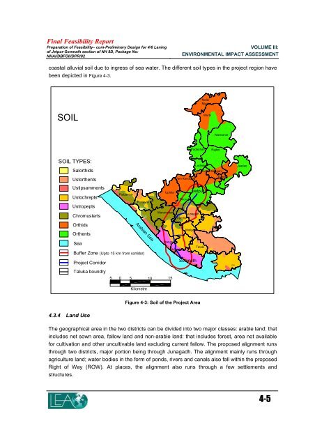
Final Feasibility Report Preparation of Feasibility– cum-Preliminary Design for 4/6 Laning of Jetpur-Somnath section of NH 8D, Package No: NHAI/DBFOII/DPR/02 VOLUME III: ENVIRONMENTAL IMPACT ASSESSMENT coastal alluvial soil due to ingress of sea water. The different soil types in the project region have been depicted in Figure 4-3. SOIL SOIL TYPES: Salorthids Ustorthents Ustipsamments Ustochrepts Ustropepts Chromusterts Orthids Orthents Sea Porbandar Ranavav Buffer Zone (Upto 15 km from corridor) Project Corridor Taluka boundry 4.3.4 Land Use Arabian Sea 5 0 5 10 15 Kilometre Upleta Manavadar Mangrol Jam Kandorna Dhoraji Somnath Malia Miyana Padadhari Rajkot Wankaner Lodhika Kotda Sangani Jetpur Junagarh Vanthli chorwad Maliya Talala Figure 4-3: Soil of the Project Area The geographical area in the two districts can be divided into two major classes: arable land: that includes net sown area, fallow land and non-arable land: that includes forest, area not available for cultivation and other uncultivable land excluding current fallow. The proposed alignment runs through two districts, major portion being through Junagadh. The alignment mainly runs through agriculture land; water bodies in the form of ponds, rivers and canals also fall within the proposed Right of Way (ROW). At places, the alignment also runs through a few settlements and structures. Morbi Gondal Una Jasdan 4-5
- Page 1 and 2: 4. DESCRIPTION OF THE ENVIRONMENT T
- Page 3: Final Feasibility Report Preparatio
- Page 7 and 8: Final Feasibility Report Preparatio
- Page 9 and 10: Final Feasibility Report Preparatio
- Page 11 and 12: Final Feasibility Report Preparatio
- Page 13 and 14: Final Feasibility Report Preparatio
- Page 15 and 16: Final Feasibility Report Preparatio
- Page 17 and 18: Final Feasibility Report Preparatio
- Page 19 and 20: Final Feasibility Report Preparatio
- Page 21 and 22: Final Feasibility Report Preparatio
- Page 23 and 24: Final Feasibility Report Preparatio
- Page 25 and 26: Final Feasibility Report Preparatio
- Page 27 and 28: Final Feasibility Report Preparatio
- Page 29 and 30: Final Feasibility Report Preparatio
- Page 31 and 32: Final Feasibility Report Preparatio
- Page 33 and 34: Final Feasibility Report Preparatio
- Page 35 and 36: Final Feasibility Report Preparatio
- Page 37 and 38: Final Feasibility Report Preparatio
- Page 39 and 40: 5. PUBLIC CONSULTATION Public consu
- Page 41 and 42: Final Feasibility Report Preparatio
- Page 43 and 44: Final Feasibility Report Preparatio
- Page 45 and 46: Final Feasibility Report Preparatio
- Page 47 and 48: Final Feasibility Report Preparatio
- Page 49 and 50: Final Feasibility Report Preparatio
Final Feasibility Report<br />
Preparation <strong>of</strong> Feasibility– cum-Preliminary Design for 4/6 Laning<br />
<strong>of</strong> Jetpur-Somnath section <strong>of</strong> NH 8D, Package No:<br />
NHAI/DBFOII/DPR/02<br />
VOLUME III:<br />
ENVIRONMENTAL IMPACT ASSESSMENT<br />
coastal alluvial soil due to ingress <strong>of</strong> sea water. The different soil types in <strong>the</strong> project region have<br />
been depicted in Figure 4-3.<br />
SOIL<br />
SOIL TYPES:<br />
Salorthids<br />
Ustor<strong>the</strong>nts<br />
Ustipsamments<br />
Ustochrepts<br />
Ustropepts<br />
Chromusterts<br />
Orthids<br />
Or<strong>the</strong>nts<br />
Sea<br />
Porbandar<br />
Ranavav<br />
Buffer Zone (Upto 15 km from corridor)<br />
Project Corridor<br />
Taluka boundry<br />
<strong>4.</strong>3.4 Land Use<br />
Arabian Sea<br />
5 0 5 10 15<br />
Kilometre<br />
Upleta<br />
Manavadar<br />
Mangrol<br />
Jam Kandorna<br />
Dhoraji<br />
Somnath<br />
Malia<br />
Miyana<br />
Padadhari Rajkot<br />
Wankaner<br />
Lodhika<br />
Kotda Sangani<br />
Jetpur<br />
Junagarh<br />
Vanthli<br />
chorwad<br />
Maliya<br />
Talala<br />
Figure 4-3: Soil <strong>of</strong> <strong>the</strong> Project Area<br />
The geographical area in <strong>the</strong> two districts can be divided into two major classes: arable land: that<br />
includes net sown area, fallow land and non-arable land: that includes forest, area not available<br />
for cultivation and o<strong>the</strong>r uncultivable land excluding current fallow. The proposed alignment runs<br />
through two districts, major portion being through Junagadh. The alignment mainly runs through<br />
agriculture land; water bodies in <strong>the</strong> form <strong>of</strong> ponds, rivers and canals also fall within <strong>the</strong> proposed<br />
Right <strong>of</strong> Way (ROW). At places, <strong>the</strong> alignment also runs through a few settlements and<br />
structures.<br />
Morbi<br />
Gondal<br />
Una<br />
Jasdan<br />
4-5


