4. description of the environment - Gujarat Pollution Control Board
4. description of the environment - Gujarat Pollution Control Board 4. description of the environment - Gujarat Pollution Control Board
Final Feasibility Report Preparation of Feasibility– cum-Preliminary Design for 4/6 Laning of Jetpur-Somnath section of NH 8D, Package No: NHAI/DBFOII/DPR/02 Figure 4-16: Literacy Rate VOLUME III: ENVIRONMENTAL IMPACT ASSESSMENT 4-34
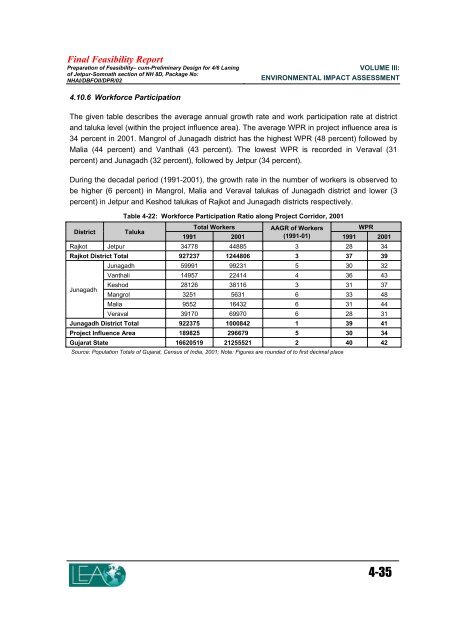
Final Feasibility Report Preparation of Feasibility– cum-Preliminary Design for 4/6 Laning of Jetpur-Somnath section of NH 8D, Package No: NHAI/DBFOII/DPR/02 4.10.6 Workforce Participation VOLUME III: ENVIRONMENTAL IMPACT ASSESSMENT The given table describes the average annual growth rate and work participation rate at district and taluka level (within the project influence area). The average WPR in project influence area is 34 percent in 2001. Mangrol of Junagadh district has the highest WPR (48 percent) followed by Malia (44 percent) and Vanthali (43 percent). The lowest WPR is recorded in Veraval (31 percent) and Junagadh (32 percent), followed by Jetpur (34 percent). During the decadal period (1991-2001), the growth rate in the number of workers is observed to be higher (6 percent) in Mangrol, Malia and Veraval talukas of Junagadh district and lower (3 percent) in Jetpur and Keshod talukas of Rajkot and Junagadh districts respectively. Table 4-22: Workforce Participation Ratio along Project Corridor, 2001 District Taluka Total Workers 1991 2001 AAGR of Workers (1991-01) WPR 1991 2001 Rajkot Jetpur 34778 44885 3 28 34 Rajkot District Total 927237 1244806 3 37 39 Junagadh Junagadh 59991 99231 5 30 32 Vanthali 14957 22414 4 36 43 Keshod 28126 38116 3 31 37 Mangrol 3251 5631 6 33 48 Malia 9552 16432 6 31 44 Veraval 39170 69970 6 28 31 Junagadh District Total 922375 1000842 1 39 41 Project Influence Area 189825 296679 5 30 34 Gujarat State 16620519 21255521 2 40 42 Source: Population Totals of Gujarat, Census of India, 2001; Note: Figures are rounded of to first decimal place 4-35
- Page 1 and 2: 4. DESCRIPTION OF THE ENVIRONMENT T
- Page 3 and 4: Final Feasibility Report Preparatio
- Page 5 and 6: Final Feasibility Report Preparatio
- Page 7 and 8: Final Feasibility Report Preparatio
- Page 9 and 10: Final Feasibility Report Preparatio
- Page 11 and 12: Final Feasibility Report Preparatio
- Page 13 and 14: Final Feasibility Report Preparatio
- Page 15 and 16: Final Feasibility Report Preparatio
- Page 17 and 18: Final Feasibility Report Preparatio
- Page 19 and 20: Final Feasibility Report Preparatio
- Page 21 and 22: Final Feasibility Report Preparatio
- Page 23 and 24: Final Feasibility Report Preparatio
- Page 25 and 26: Final Feasibility Report Preparatio
- Page 27 and 28: Final Feasibility Report Preparatio
- Page 29 and 30: Final Feasibility Report Preparatio
- Page 31 and 32: Final Feasibility Report Preparatio
- Page 33: Final Feasibility Report Preparatio
- Page 37 and 38: Final Feasibility Report Preparatio
- Page 39 and 40: 5. PUBLIC CONSULTATION Public consu
- Page 41 and 42: Final Feasibility Report Preparatio
- Page 43 and 44: Final Feasibility Report Preparatio
- Page 45 and 46: Final Feasibility Report Preparatio
- Page 47 and 48: Final Feasibility Report Preparatio
- Page 49 and 50: Final Feasibility Report Preparatio
Final Feasibility Report<br />
Preparation <strong>of</strong> Feasibility– cum-Preliminary Design for 4/6 Laning<br />
<strong>of</strong> Jetpur-Somnath section <strong>of</strong> NH 8D, Package No:<br />
NHAI/DBFOII/DPR/02<br />
<strong>4.</strong>10.6 Workforce Participation<br />
VOLUME III:<br />
ENVIRONMENTAL IMPACT ASSESSMENT<br />
The given table describes <strong>the</strong> average annual growth rate and work participation rate at district<br />
and taluka level (within <strong>the</strong> project influence area). The average WPR in project influence area is<br />
34 percent in 2001. Mangrol <strong>of</strong> Junagadh district has <strong>the</strong> highest WPR (48 percent) followed by<br />
Malia (44 percent) and Vanthali (43 percent). The lowest WPR is recorded in Veraval (31<br />
percent) and Junagadh (32 percent), followed by Jetpur (34 percent).<br />
During <strong>the</strong> decadal period (1991-2001), <strong>the</strong> growth rate in <strong>the</strong> number <strong>of</strong> workers is observed to<br />
be higher (6 percent) in Mangrol, Malia and Veraval talukas <strong>of</strong> Junagadh district and lower (3<br />
percent) in Jetpur and Keshod talukas <strong>of</strong> Rajkot and Junagadh districts respectively.<br />
Table 4-22: Workforce Participation Ratio along Project Corridor, 2001<br />
District Taluka<br />
Total Workers<br />
1991 2001<br />
AAGR <strong>of</strong> Workers<br />
(1991-01)<br />
WPR<br />
1991 2001<br />
Rajkot Jetpur 34778 44885 3 28 34<br />
Rajkot District Total 927237 1244806 3 37 39<br />
Junagadh<br />
Junagadh 59991 99231 5 30 32<br />
Vanthali 14957 22414 4 36 43<br />
Keshod 28126 38116 3 31 37<br />
Mangrol 3251 5631 6 33 48<br />
Malia 9552 16432 6 31 44<br />
Veraval 39170 69970 6 28 31<br />
Junagadh District Total 922375 1000842 1 39 41<br />
Project Influence Area 189825 296679 5 30 34<br />
<strong>Gujarat</strong> State 16620519 21255521 2 40 42<br />
Source: Population Totals <strong>of</strong> <strong>Gujarat</strong>, Census <strong>of</strong> India, 2001; Note: Figures are rounded <strong>of</strong> to first decimal place<br />
4-35


