PDF (Lo-Res) - Smithsonian Institution Libraries
PDF (Lo-Res) - Smithsonian Institution Libraries
PDF (Lo-Res) - Smithsonian Institution Libraries

You also want an ePaper? Increase the reach of your titles
YUMPU automatically turns print PDFs into web optimized ePapers that Google loves.
NUMBER 89<br />
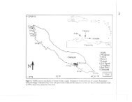
<strong>Lo</strong>cality 9, Western Maunganui Dunes<br />
(Cape Pattison E-Maunganui)<br />
NZA 1950: Paphies subtriangulatum, MNZ S27830; GR<br />
277761; Maunganui, Midden Site, 50 m E of Moravian Mission<br />
Stone Cottage. Marine midden shell from uppermost 10<br />
cm of chocolate brown soil horizon (-35 cm thick) overlying<br />
natural dune sequence; 760 ± 140 yrs BP; 395 CAL BP;<br />
634-121 CAL BP.<br />
NZA 1949: Gallirallus dieffenbachii, MNZ S27831; GR<br />
277761; Maunganui, Midden Site, 50 m E of Moravian Mission<br />
Stone Cottage. From brown, humic-stained dune sand,<br />
-40 cm below NZA 1950; 1340 ± 150 yrs BP; ca. 1200<br />
CAL BP; 1501-931 CAL BP.<br />
NZA 1981: Gallirallus dieffenbachii, MNZ S27832; GR<br />
277761; Maunganui, Midden Site, 50 m E of Moravian Mission<br />
Stone Cottage. From pale brown/gray, consolidated<br />
dune sand, -70 cm below NZA 1950; 1830 ± 150 yrs BP;<br />
1702 CAL BP; 2008-1353 CAL BP.<br />
<strong>Lo</strong>cality 10, Mid-Maunganui Dunes<br />
(Maunganui E-Washout Creek)<br />
NZA 1947: Diaphorapteryx hawkinsi, MNZ S27828; GR<br />
286760; Maunganui, in situ in pale brown, semiconsolidated<br />
foredune sand, 150 m E of Maunganui Bluff, -3 m<br />
a.s.l.; 1860 ± 150 yrs BP; 1734 CAL BP; 2102-1400 CAL<br />
BP.<br />
NZA 3608: Gallirallus dieffenbachii, MNZ S32892; GR<br />
288760; Maunganui, -4 m a.s.l., in back-beach dune face,<br />
from upper level of -2 m thick, black brown (humicstained)<br />
dune sand, here overlain by 50 cm thick layer of occupation-midden<br />
shell; 677 ± 60 yrs BP; ca. 600 CAL BP;<br />
667-535 CAL BP.<br />
NZA 2585: Gallirallus dieffenbachii, MNZ S29026; GR<br />
289758; Maunganui, in brown sand of inland dune series,<br />
-6 m a.sl, -300 m W of distinctive Basalt Knob; 4282 ± 89<br />
yrs BP; ca. 4750 CAL BP; 5024-4523 CAL BP.<br />
NZA 3189: Hemiphaga chathamensis, MNZ S32846; GR<br />
289758; Maunganui, in brown sand of inland dune series,<br />
-6 m a.s.l., -300 m W of Basalt Knob. From fine, pale<br />
brown sand that seen laterally is overlain by thin (-10 cm)<br />
orange-colored sand layer (iron-stained) then 50 cm thick<br />
stratum of gray/black sandy soil. This sand/soil sequence<br />
here overlain by compact, 20 cm thick midden-shell layer,<br />
topped by recent drift sand; 4113 ± 67 yrs BP; ca. 4600 CAL<br />
BP; 4820^1411 CAL BP.<br />
NZA 3191: Diaphor apteryx hawkinsi, MNZ S32834; GR<br />
292758; Maunganui, immediately E of Basalt Knob, within<br />
inland dune series, from brown sand near base of N wall of<br />
-8 m deep, nearly circular, steep-sided deflation hollow;<br />
3857 ± 65 yrs BP; ca. 4200 CAL BP; 4406-3991 CAL BP.<br />
NZA 3190: Tadorna, species undescribed, MNZ S32830; GR<br />
292758; Maunganui, immediately E of Basalt Knob, from<br />
pale brown sand layer, 2 m below (stratigraphically) brown<br />
sand from which NZA 3191 was obtained; 5291 ± 66 yrs<br />
BP; ca. 6030 CAL BP; 6187-5902 CAL BP.<br />
<strong>Lo</strong>cality 11, Eastern Maunganui Dunes<br />
(Washout Creek E-Tahatika Creek)<br />
105<br />
NZA 1982: Hemiphaga chathamensis, MNZ S27832; GR<br />
307758; Maunganui, in inland dune series, -1.2 km E of<br />
Washout Creek (50 m W of Big Midden Site). From brown<br />
sand on south-facing deflation surface, -5-6 m a.s.l. (stratigraphic<br />
equivalent of NZA 3189, NZA 3287); 3760 ± 160<br />
yrs BP; 4067 CAL BP; 4510-3635 CAL BP.<br />
NZA 2614: Gallirallus dieffenbachii, MNZ S32031; GR<br />
308758; Maunganui, in inland dune series, -1.25 km E of<br />
Washout Creek (Big Midden Site). From dark-stained sand<br />
-30 cm beneath compact, 20 cm thick midden-shell horizon;<br />
1390 ± 80 yrs BP; 1247 CAL BP; 1386-1069 CAL BP.<br />
NZA 3287: Diaphorapteryx hawkinsi, MNZ S (uncataloged);<br />
GR 308758; Maunganui, in inland dune series, -1.25 km E<br />
of Washout Creek (Big Midden Site). In situ in brown sand<br />
on south-sloping deflation surface, -5-6 m a.s.l. (stratigraphic<br />
equivalent of NZA 1982, NZA 3189); 3966 ± 60 yrs<br />
BP; 4350 CAL BP; 4517^152 CAL BP.<br />
NZA 2609: Hemiphaga chathamensis, MNZ S30778; GR<br />
347771; Maunganui, on ridge crest of inland dune series,<br />
-500 m W of Tahatika Creek. In situ skeleton from pale<br />
brown sand at -1.2 m, beneath -10 cm thick, orange,<br />
iron-stained zone and brown black sandy soil, 30 cm thick,<br />
with rounded lag pebbles on surface; 3264 ± 84 yrs BP; ca.<br />
3450 CAL BP; 3631-3218 CAL BP.<br />
NZA 3286: Pachyanas chathamica, MNZ S32634; GR<br />
349773; Tahatika, in situ in pale, gray brown sand, on low<br />
foredune (-2 m a.s.l.), -250 m W of Tahatika Creek; 1529 ±<br />
57 yrs BP; 1373 CAL BP; 1502-1293 CAL BP.<br />
NZA 3284: Fulica chathamensis, MNZ S (uncataloged); GR<br />
351772; Tahatika, from gullied, older red brown<br />
(iron-stained) sand, -4 m a.s.l., on seaward (N) slopes of inland<br />
dune series, -150 m W of Tahatika Creek; 3296 ± 59<br />
yrs BP; ca. 3450 CAL BP; 3621-3361 CAL BP.<br />
NZA 796: Cygnus sumnerensis, MNZ S26482; GR 354773;<br />
Tahatika, from seaward foredune slope, -2 m a.s.l., 250 m E<br />
of Tahatika Creek (stratigraphic equivalent of NZA 3286);<br />
1490 ± 130 yrs BP; 1351 CAL BP; 1606-1068 CAL BP.<br />
NZA 1937: Cygnus sumnerensis, MNZ S27827; GR 354773;<br />
Tahatika, from brown sand forming nearly level deflation<br />
surface inland of foredune slope (cf. NZA 796), -3 m a.s.l.,<br />
250 m E of Tahatika Creek; 1420 ± 140 yrs BP; 1276 CAL<br />
BP; 1533-985 CAL BP.<br />
NZA 2603: Cygnus sumnerensis, MNZ S30709; GR<br />
354773; Tahatika, from brown sand ridge upon main deflation<br />
surface (cf. NZA 1937), -3 m a.s.l., -300 m E of Tahatika<br />
Creek ; 792 ± 77 yrs BP; ca. 700 CAL BP; 891-549<br />
CAL BP.